
PROPERTY-INSURANCE CLAIM HELP · FL & SC FL CITIESSC CITIESGUIDESTATESNEWSSITE MAPABOUT
HurricaneLaw.Pro HURRICANELAW.PRO
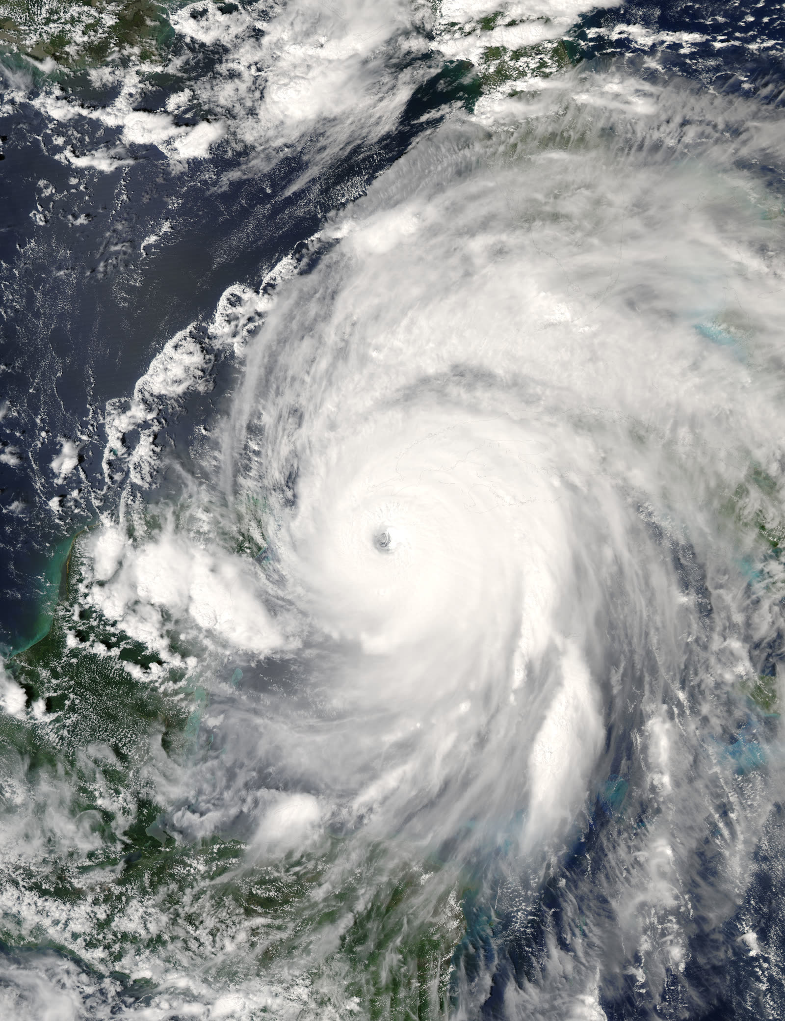
Ivan near Category 5 peak intensity in the western Caribbean, September 13, 2004
STORM ARCHIVE / 2004 LANDFALL 30.2°N 87.9°W
CAT 3 AT LANDFALL PEAK CAT 5 FL · 2004 · 165 mph

Hurricane Ivan

Landfall: Gulf Shores, AL (core impact Pensacola / Perdido Key) · 2004-09-16. Beachfront slabs from Perdido Key to Orange Beach previewed Katrina's wind-vs-flood fight a year early

NASA / NOAA (MODIS)
AT LANDFALL
CAT 3
PEAK INTENSITY
CAT 5 · 165 mph
PRESSURE
946 mb
STORM SURGE
10–15 ft
DAMAGE
$18.8B
DEATHS
25
01 THE PATH

Where it hit, start to finish

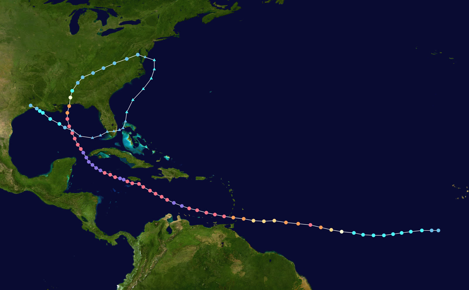
TRACK · HURRICANE IVANNOAA / NHC (best-track data)
Best track of Hurricane Ivan, September 2–24, 2004 — including the loop and second Gulf landfall
Grenada / Caribbean
CAT 5 THREE TIMES

Ivan reached Category 5 three times, peaking at 165 mph and 910 mb. It wrecked Grenada, then swept Grand Cayman with 8–10 ft of surge and 20–30 ft waves — 95% of buildings there damaged or destroyed.

Northern Gulf
EXTREME WAVES

Approaching the coast, Ivan generated some of the largest waves ever measured in the Gulf. Wave action on top of surge — not wind alone — would do much of the coastal structural damage.

Gulf Shores, AL
CAT 3 LANDFALL — 0650 UTC SEPT 16

Landfall just west of Gulf Shores at 120 mph and 946 mb, with the strongest winds in the eastern eyewall over Perdido Key and Perdido Bay — west of Pensacola. Surge ran 10–15 ft from Destin to Mobile Bay.

Pensacola / Escambia Bay, FL
I-10 BRIDGE DOWN

Waves atop the surge knocked as much as a quarter-mile of the Interstate 10 bridge into Escambia Bay and heavily damaged the US 90 causeway. Perdido Key was essentially leveled; thousands of homes in Escambia, Santa Rosa, and Baldwin counties were damaged or destroyed.

Southeast US
117 TORNADOES, INLAND FLOODS

Ivan's remnants spawned 117 tornadoes over three days and flooding rain to the Mid-Atlantic. Direct US deaths: 25. US damage: $18.8 billion nominal — 2004's costliest storm.

Gulf of Mexico (again)
THE LOOP

Ivan's remnant low looped back across Florida into the Gulf, regenerated, and made a second landfall in southwest Louisiana September 24 as a tropical depression — a meteorological oddity that bookended a 22-day track.

02 THE RECORD IN IMAGES
ALL IMAGERY U.S. GOV / PUBLIC DOMAIN
DAMAGE Public domain via Wikimedia Commons
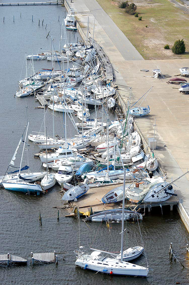
Boats piled ashore at the Naval Air Station Pensacola marina — the base sustained $800–900 million in damage
SURGE US Fish & Wildlife Service
Surge destruction at Bon Secour National Wildlife Refuge on the Alabama coast, west of the landfall point
MAP NOAA / WPC (David Roth)
US rainfall from Ivan and its remnants — flooding rains ran from the Gulf Coast to the Mid-Atlantic

The storm

Ivan was the 2004 season's monster — a classical Cape Verde hurricane that reached Category 5 three times, peaking at 165 mph and 910 mb. It devastated Grenada, then buried Grand Cayman under 8–10 feet of surge topped by 20–30-foot waves.

Weakening slowly over cooler shelf water, Ivan made its first US landfall at 0650 UTC on September 16, 2004, just west of Gulf Shores, Alabama, as a Category 3 — 120 mph, 946 mb. The geometry mattered: the strongest winds rode the eastern eyewall across Perdido Key and Perdido Bay, putting the worst of the storm on the Florida side of the line, over greater Pensacola. Surge of 10 to 15 feet ran from Destin westward to Mobile Bay, driven by some of the largest waves ever measured in the Gulf. Ivan then produced a 117-tornado outbreak and flooding rain across the Southeast — and, in a final oddity, its remnant low looped back over Florida into the Gulf, regenerated, and hit Louisiana as a depression on September 24. Direct US deaths: 25. US damage: $18.8 billion nominal.
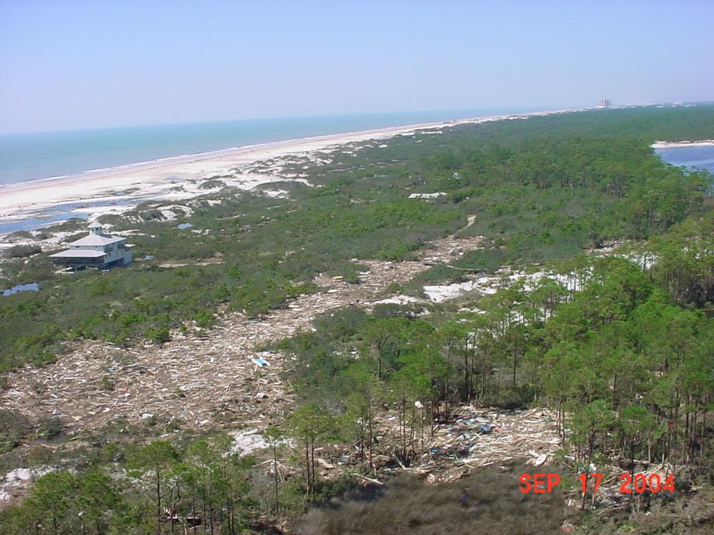
Surge destruction at Bon Secour National Wildlife Refuge on the Alabama coast, west of the landfall point
Surge destruction at Bon Secour National Wildlife Refuge on the Alabama coast, west of the landfall point US Fish & Wildlife Service

The damage

Escambia Bay's Interstate 10 bridge lost as much as a quarter-mile of roadway to wave action on top of surge; the US 90 causeway was heavily damaged too. Perdido Key was essentially leveled — beachfront houses, condos, and apartment buildings reduced in places to pilings and slabs. Innerarity Point and Orange Beach took severe surf and wind damage; thousands of homes across Escambia, Santa Rosa, and Baldwin counties were damaged or destroyed. Naval Air Station Pensacola sustained $800–900 million in damage. Inland, Ivan flattened timber — the Alabama Forestry Commission valued damaged timber at about $610 million across 2.7 million acres — and shut down a quarter of Gulf oil production for weeks.
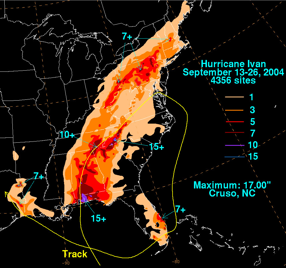
US rainfall from Ivan and its remnants — flooding rains ran from the Gulf Coast to the Mid-Atlantic
US rainfall from Ivan and its remnants — flooding rains ran from the Gulf Coast to the Mid-Atlantic NOAA / WPC (David Roth)

The insurance aftermath

Insured US losses reached $7.11 billion, more than $4 billion of it in Florida — and Ivan produced the claim type that would dominate Gulf Coast insurance law for the next decade: the slab case. Where a beachfront home was reduced to its foundation, wind carriers argued surge (excluded flood) destroyed it; NFIP flood limits were often far below rebuild cost; and the policyholder was left to prove which force struck first. These wind-versus-flood allocation fights along Perdido Key and Orange Beach ran a full year before Katrina made "slab litigation" a national story — same arguments, same anti-concurrent-causation policy language.

Florida total losses carried an extra twist: under the Valued Policy Law as read by Mierzwa (decided months earlier), a total loss with any covered wind contribution arguably obligated the wind carrier for full policy limits. Carriers' Ivan exposure was part of what pushed the Legislature to amend § 627.702 in 2005 — the fight is detailed in the Charley dossier.

Ivan was also the third Florida landfall in five weeks. Panhandle policyholders joined the multi-deductible pool that produced the December 2004 reimbursement program and the 2005 single-season deductible law (see Frances). And the rebuild was slow enough that when Dennis arrived ten months later, much of the coast was still under blue tarps — turning Dennis claims into arguments about pre-existing Ivan damage.
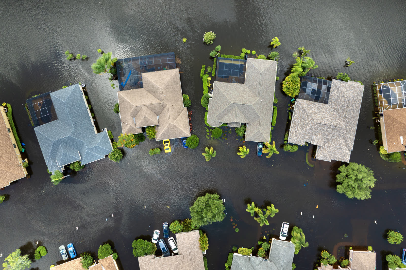
Tropical-storm flooding, Florida
Tropical-storm flooding, Florida HURRICANELAW.PRO FIELD FOOTAGE

What policyholders learned

  • The wind/flood line is drawn by evidence. Owners with time-stamped photos, video, stopped clocks, and neighbor accounts establishing wind damage before the surge arrived preserved the wind portion of slab claims; those without often recovered only NFIP limits.
  • Two policies, two claims, always. Households with both wind and flood coverage who filed and documented both claims separately — rather than letting one adjuster characterize the whole loss — recovered more.
  • Wave damage is still flood. Courts treated wave action atop surge as excluded water damage under homeowners policies; the coverage answer was an NFIP or excess flood policy bought before the storm.
  • Engineering reports cut both ways. Carrier-hired engineers who attributed everything to surge were rebuttable; policyholders who commissioned independent structural assessments changed outcomes.
  • Document the tarp era. With Dennis ten months out, owners who photographed completed repairs — and kept receipts — could defeat later "pre-existing damage" denials.

Independent informational resource — not legal advice. Damage figures are nominal (not inflation-adjusted) unless noted. Insurance-law summaries are drafted for education; consult an attorney about your specific claim.

AT LANDFALL · HURRICANE IVAN · 2004
10–15 ft
OF STORM SURGE · DESTIN TO MOBILE BAY
HURRICANELAW.PRO FIELD FOOTAGE
03 THE FULL RECORD

Every official record of Ivan

Reports, imagery archives, flood data, and claims records — straight from the agencies.

OUR LAW FIRM PARTNER · HALVERSEN LAW
Ivan claim denied?
CALL FL941-390-3233CALL SC843-542-0454FREE CLAIM REVIEW
RELATED GUIDES
HurricaneLaw.Pro HURRICANELAW.PRO

The independent policyholder resource for Florida & South Carolina — storm archive, coverage law, denials, bad faith, and the complete claims playbook. 51 storms · 46 carriers · 97 public-adjuster firms · 37 city guides.

▸ SEE THE FULL SITE MAP — EVERY PAGE →
STORM ALERTS SOURCED FROM NOAA / NHC
SOUTH CAROLINA
496 Bramson Court, Suite 100
Mount Pleasant, SC 29464
CALL OR TEXT
FLORIDA
Tampa, FL
CALL OR TEXT
CLAIMS 9
DENIALS 8
BAD FAITH 7
COVERAGE 12
COMMERCIAL 8
ROOFS 8
TREES 5
DIRECTORIES
STORMS 51
WEATHER
NEWS & SITE 19
STORM ARCHIVE, CITIES & NEWS
Most recent below. Every storm dossier, city resource, and article is on its hub (linked at each heading) or the grouped site map →. All 46 carriers and 97 public-adjuster firms are in the Directories column above.
STORM ARCHIVE · 51 →
Hurricane Debby 2024Hurricane Helene 2024Hurricane Milton 2024Hurricane Idalia 2023Hurricane Ian 2022Hurricane Nicole 2022Hurricane Ida 2021Hurricane Laura 2020 View all 51 →
FLORIDA CITY RESOURCES · 29 →
Boca RatonBradentonCape CoralClearwaterDaytona BeachDestinFort LauderdaleFort Myers View all 29 →
SOUTH CAROLINA CITY RESOURCES · 8 →
BeaufortCharlestonColumbiaFlorenceGreenvilleHilton Head IslandMount PleasantMyrtle Beach
NEWS & UPDATES · 19 →

HurricaneLaw.Pro is an independent informational resource, not a law firm. Coverage summaries, policy-language quotations, dollar figures, deadlines, and chart examples throughout this site are general information based on typical or standard policy forms and are illustrative only — they are not a quote, a guarantee of coverage, or a promise of any outcome. Every insurance policy is different: your own policy, endorsements, and state law control, so read your policy and confirm current statutes. Weather imagery courtesy of NOAA, the National Hurricane Center, and the National Weather Service. Legal services are provided by our law firm partner, Halversen Law. Nothing on this site is legal advice; consult an attorney about your specific claim.

PrivacyTermsDisclaimerAboutContact
© 2026 HURRICANELAW.PRO — ALL RIGHTS RESERVED 27.9°N 82.5°W · ATLANTIC BASIN MONITOR
OUR LAW FIRM PARTNER
Halversen Law LICENSED · FLORIDA & SOUTH CAROLINA

All legal matters on this site are referred to and handled by our law firm partner, Halversen Law, a licensed law firm in Florida and South Carolina. HurricaneLaw.Pro is an informational resource and is not itself a law firm.

FREE CASE REVIEW