

PROPERTY-INSURANCE CLAIM HELP · FL & SC FL CITIESSC CITIESGUIDESTATESNEWSSITE MAPABOUT
HurricaneLaw.Pro HURRICANELAW.PRO
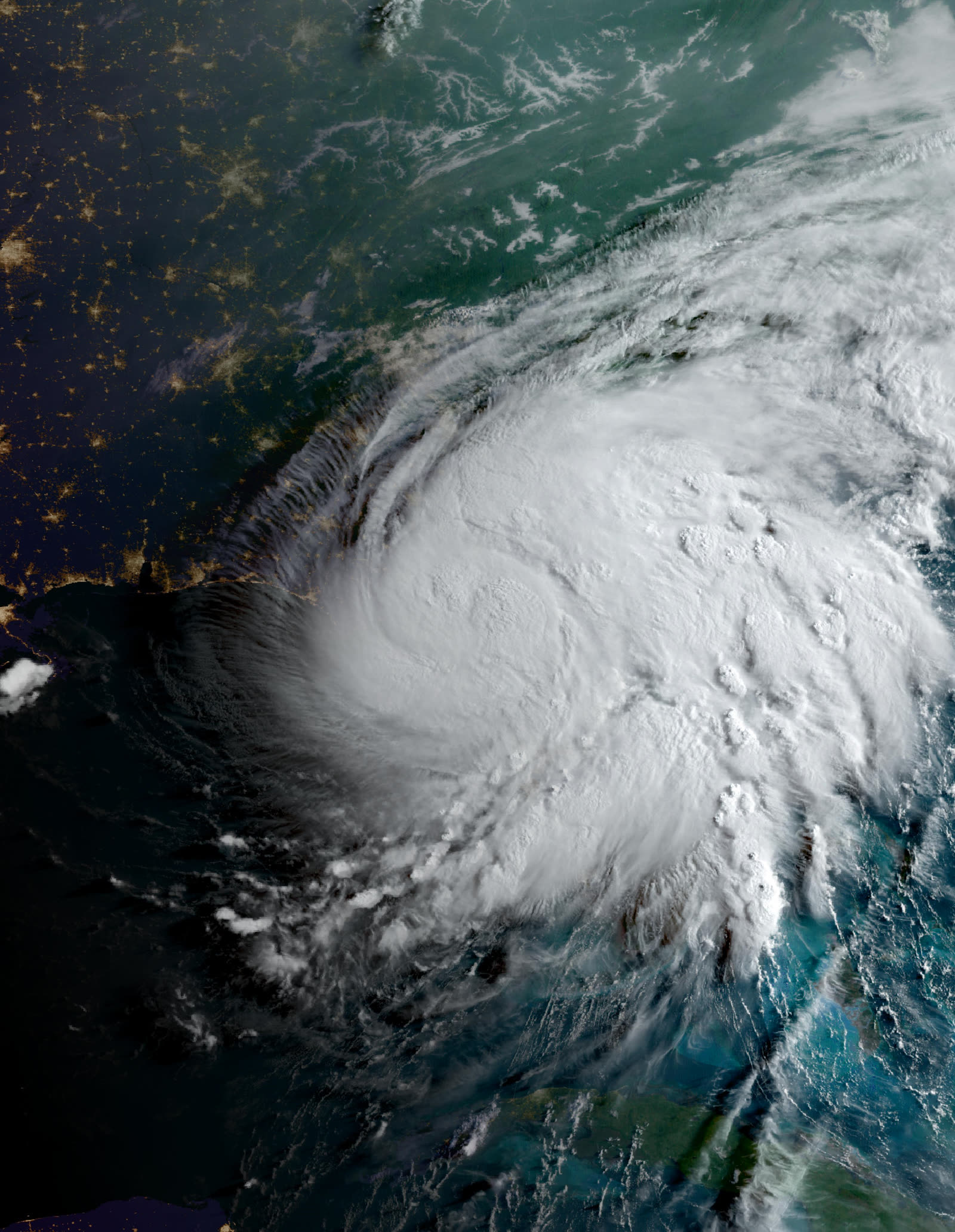
Debby at its Category 1 landfall near Steinhatchee on the morning of August 5, 2024
STORM ARCHIVE / 2024 LANDFALL 29.7°N 83.4°W
CAT 1 FL & SC · 2024 · 80 mph

Hurricane Debby

Landfall: Steinhatchee, FL; second landfall near Bulls Bay, SC · 2024-08-05. Debby's wind was a footnote — its stalled rain flooded Sarasota, Savannah, and the SC Lowcountry, and most of that water hit homes with no flood policy

NOAA / NESDIS (GOES-16)
AT LANDFALL
CAT 1
PEAK WIND
80 mph
PRESSURE
979 mb
STORM SURGE
3-6 ft
DAMAGE
~$2.5B
DEATHS
10
01 THE PATH

Where it hit, start to finish

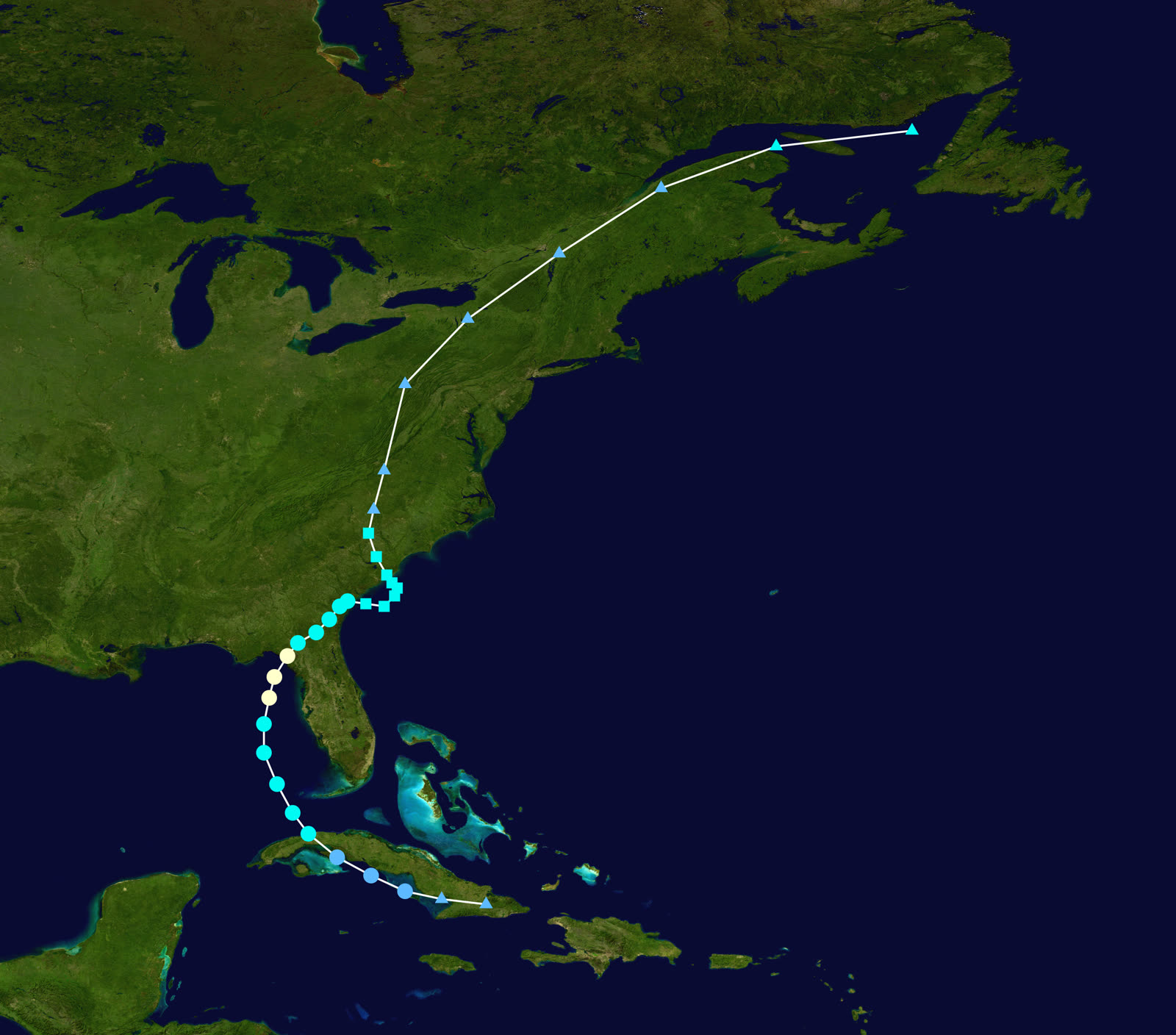
TRACK · HURRICANE DEBBYNOAA / NHC (best-track data)
Best track of Hurricane Debby, August 3-9, 2024 — the stall off the Georgia-Carolina coast drove the flood disaster
Eastern Gulf of Mexico
QUICK SPIN-UP OVER HOT WATER

Debby crossed Cuba as a wave, organized August 3-4 over a record-warm Gulf, and reached hurricane strength the night before landfall.

Steinhatchee, FL
CAT 1 LANDFALL - 80 MPH

Landfall 7 a.m. EDT August 5 near Steinhatchee at 80 mph and 979 mb — the second hurricane to strike the Big Bend in under a year, with 3-6 ft of surge across the same Idalia-scarred coast and a near-record tide at Cedar Key.

Sarasota / Manatee counties, FL
RAIN FLOOD FAR FROM THE CENTER

Debby's eastern bands trained over the Sarasota area, dropping 15+ inches; neighborhoods like Laurel Meadows flooded from rainfall runoff alone, 150 miles from landfall.

Savannah, GA / SC Lowcountry
THE STALL

Debby crawled to the Atlantic and stalled August 6-7, pinwheeling rain bands into Savannah, Charleston, and Huger; tornado warnings and flash flooding ran for days.

Bulls Bay, SC
SECOND LANDFALL - AUGUST 8

Debby looped back ashore as a 50-mph tropical storm near Bulls Bay. Horry County recorded 19.03 inches of rain; the Waccamaw and Lowcountry rivers stayed in flood for weeks.

Eastern seaboard
DISSIPATION NORTH

The remnants ran the Appalachians and Northeast with flash flooding through August 9. Toll: 10 deaths and roughly $2.5 billion — most of it freshwater flood.

02 THE RECORD IN IMAGES
ALL IMAGERY U.S. GOV / PUBLIC DOMAIN
SATELLITE NASA (MODIS)
Debby organizing in the eastern Gulf on August 4, the day before landfall
RADAR NOAA / NWS
Radar loop of Debby's Big Bend landfall, August 5, 2024
CONE NOAA / NHC
NHC forecast cone showing the slow crawl up the Southeast coast
AERIAL NOAA / NGS
NOAA damage-assessment aerial of Cedar Key after Debby's surge
FLOOD Wikimedia Commons (CC0)
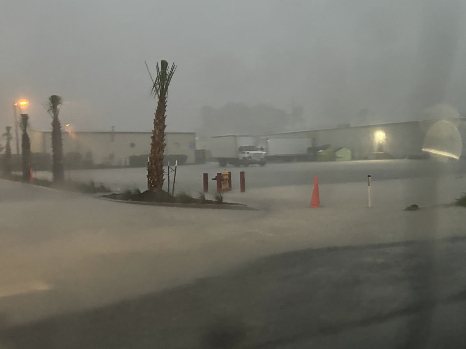
Street flooding in North Myrtle Beach, SC, as Debby stalled offshore
MAP NOAA / WPC
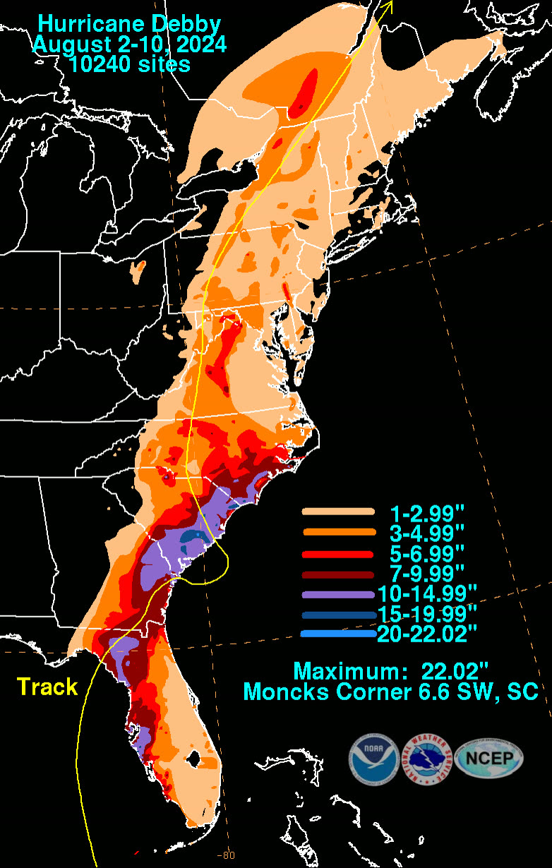
Storm-total rainfall along Debby's track — nearly 20 inches in Horry County, SC

The storm

Debby organized fast over a record-warm Gulf and made landfall near Steinhatchee at 7 a.m. EDT on August 5, 2024, as a Category 1 — 80 mph, 979 mb — the second hurricane to strike Florida's Big Bend in under a year, crossing the same coast Idalia had wrecked eleven months earlier. Surge ran 3-6 feet, with a near-record tide at Cedar Key.

Then the storm slowed to a walk, and the walk was the disaster. Debby crossed north Florida, drifted to the Atlantic, and stalled off the Georgia-South Carolina coast for two days, pinwheeling rain bands into Savannah and the Lowcountry before looping back ashore near Bulls Bay, South Carolina, on August 8 as a tropical storm. Rain totals told the story: 15+ inches around Sarasota — 150 miles from landfall — double-digit totals across southeast Georgia, and 19.03 inches in Horry County, South Carolina. Ten deaths and roughly $2.5 billion in damage, the overwhelming share of it freshwater flooding.
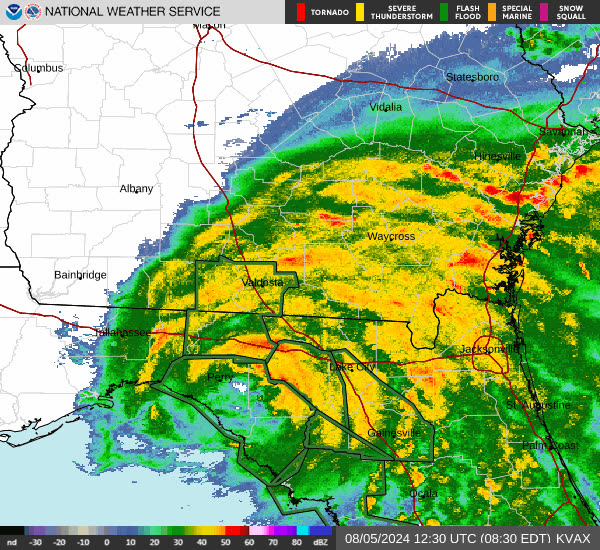
Radar loop of Debby's Big Bend landfall, August 5, 2024
Radar loop of Debby's Big Bend landfall, August 5, 2024 NOAA / NWS

The damage

The Big Bend took a repeat hit it hadn't finished repairing: surge into Steinhatchee, Horseshoe Beach, and Cedar Key, where NOAA's post-storm aerials showed water lines through the same streets Idalia flooded. Wind damage was modest and localized.

The bigger losses were nowhere near the center. In Sarasota and Manatee counties, rainfall runoff flooded inland subdivisions — Laurel Meadows became the emblem — where homeowners watched water rise out of retention ponds and into living rooms under sunny-day forecasts of a "Gulf coast brush." In South Carolina and Georgia, flash flooding hit Savannah, Charleston, Huger, and North Myrtle Beach, and then the slow disaster followed: the Waccamaw, Edisto, and Lowcountry rivers stayed at flood stage for weeks after Debby's second landfall.
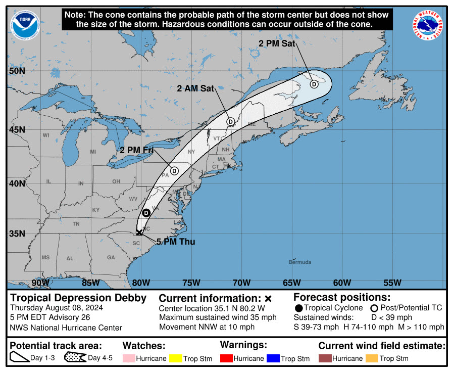
NHC forecast cone showing the slow crawl up the Southeast coast
NHC forecast cone showing the slow crawl up the Southeast coast NOAA / NHC

The insurance aftermath

FLOIR's Debby data call (September 2024) counted 19,973 Florida claims and $121.5 million in estimated insured losses — small numbers that hide the storm's real insurance story, because Debby's dominant peril was excluded from almost every policy that could have responded.

Rain-driven flooding from the ground up is flood, not wind, under standard homeowners forms. In Sarasota's flooded subdivisions — inland, outside mapped high-risk zones — NFIP take-up was thin, and carriers reported just 105 private flood claims statewide. The characteristic Debby dispute was a homeowner with wet floors and a wind policy: carriers denied under the flood exclusion, and policyholders argued for covered causes — wind-created openings, wind-driven rain, or sewer/drain backup where endorsed. The same fight ran through the Lowcountry, where South Carolina's weeks-long river flooding fell to NFIP policies that most inland households didn't carry. FEMA declarations (DR-4806 Florida, DR-4835 South Carolina) and SBA loans became the default recovery route.

Debby also set up the season's cruelest sequencing problem. Seven weeks later, Helene's surge swept the same Big Bend towns, and Milton followed into Sarasota; adjusters spent the fall allocating damage among three storms — three deductibles, three claim files — on houses that never got dry between them. Big Bend owners still awaiting Debby repairs saw those claims absorbed into far larger Helene files.

NOAA damage-assessment aerial of Cedar Key after Debby's surge
NOAA damage-assessment aerial of Cedar Key after Debby's surge NOAA / NGS

What policyholders learned

  • Inland rain flooding is excluded from homeowners policies — everywhere. Sarasota and Lowcountry losses turned almost entirely on whether a flood policy existed before the storm. "Not in a flood zone" is a lending category, not a physics category.
  • Named-storm deductibles applied even where damage was pure water. Debby triggered hurricane deductibles in Florida; small wind claims closed below threshold while the water loss went unpaid — a double gap.
  • Covered-cause arguments needed evidence. Policyholders who documented wind-created openings, backed-up drains (where endorsed), or sudden interior leaks before floodwater rose preserved the covered portion of mixed claims.
  • River crests weeks later are still Debby claims. SC owners documented high-water marks and dates as rivers peaked long after the storm — critical for NFIP proof-of-loss deadlines.
  • Photograph everything before the next storm. Debby-then-Helene allocation disputes were decided by dated documentation; owners with none defaulted to whichever storm's deductible the carrier preferred.

Independent informational resource — not legal advice. Damage figures are nominal (not inflation-adjusted) unless noted. Insurance-law summaries are drafted for education; consult an attorney about your specific claim.

AT LANDFALL · HURRICANE DEBBY · 2024
3-6 ft
OF STORM SURGE · BIG BEND COAST
HURRICANELAW.PRO FIELD FOOTAGE
03 THE FULL RECORD

Every official record of Debby

Reports, imagery archives, flood data, and claims records — straight from the agencies.

OUR LAW FIRM PARTNER · HALVERSEN LAW
Debby claim denied?
CALL FL941-390-3233CALL SC843-542-0454FREE CLAIM REVIEW
RELATED GUIDES
HurricaneLaw.Pro HURRICANELAW.PRO

The independent policyholder resource for Florida & South Carolina — storm archive, coverage law, denials, bad faith, and the complete claims playbook. 51 storms · 46 carriers · 97 public-adjuster firms · 37 city guides.

▸ SEE THE FULL SITE MAP — EVERY PAGE →
STORM ALERTS SOURCED FROM NOAA / NHC
SOUTH CAROLINA
496 Bramson Court, Suite 100
Mount Pleasant, SC 29464
CALL OR TEXT
FLORIDA
Tampa, FL
CALL OR TEXT
CLAIMS 9
DENIALS 8
BAD FAITH 7
COVERAGE 12
COMMERCIAL 8
ROOFS 8
TREES 5
DIRECTORIES
STORMS 51
WEATHER
NEWS & SITE 19
STORM ARCHIVE, CITIES & NEWS
Most recent below. Every storm dossier, city resource, and article is on its hub (linked at each heading) or the grouped site map →. All 46 carriers and 97 public-adjuster firms are in the Directories column above.
STORM ARCHIVE · 51 →
Hurricane Debby 2024Hurricane Helene 2024Hurricane Milton 2024Hurricane Idalia 2023Hurricane Ian 2022Hurricane Nicole 2022Hurricane Ida 2021Hurricane Laura 2020 View all 51 →
FLORIDA CITY RESOURCES · 29 →
Boca RatonBradentonCape CoralClearwaterDaytona BeachDestinFort LauderdaleFort Myers View all 29 →
SOUTH CAROLINA CITY RESOURCES · 8 →
BeaufortCharlestonColumbiaFlorenceGreenvilleHilton Head IslandMount PleasantMyrtle Beach
NEWS & UPDATES · 19 →

HurricaneLaw.Pro is an independent informational resource, not a law firm. Coverage summaries, policy-language quotations, dollar figures, deadlines, and chart examples throughout this site are general information based on typical or standard policy forms and are illustrative only — they are not a quote, a guarantee of coverage, or a promise of any outcome. Every insurance policy is different: your own policy, endorsements, and state law control, so read your policy and confirm current statutes. Weather imagery courtesy of NOAA, the National Hurricane Center, and the National Weather Service. Legal services are provided by our law firm partner, Halversen Law. Nothing on this site is legal advice; consult an attorney about your specific claim.

PrivacyTermsDisclaimerAboutContact
© 2026 HURRICANELAW.PRO — ALL RIGHTS RESERVED 27.9°N 82.5°W · ATLANTIC BASIN MONITOR
OUR LAW FIRM PARTNER
Halversen Law LICENSED · FLORIDA & SOUTH CAROLINA

All legal matters on this site are referred to and handled by our law firm partner, Halversen Law, a licensed law firm in Florida and South Carolina. HurricaneLaw.Pro is an informational resource and is not itself a law firm.

FREE CASE REVIEW