
PROPERTY-INSURANCE CLAIM HELP · FL & SC FL CITIESSC CITIESGUIDESTATESNEWSSITE MAPABOUT
HurricaneLaw.Pro HURRICANELAW.PRO
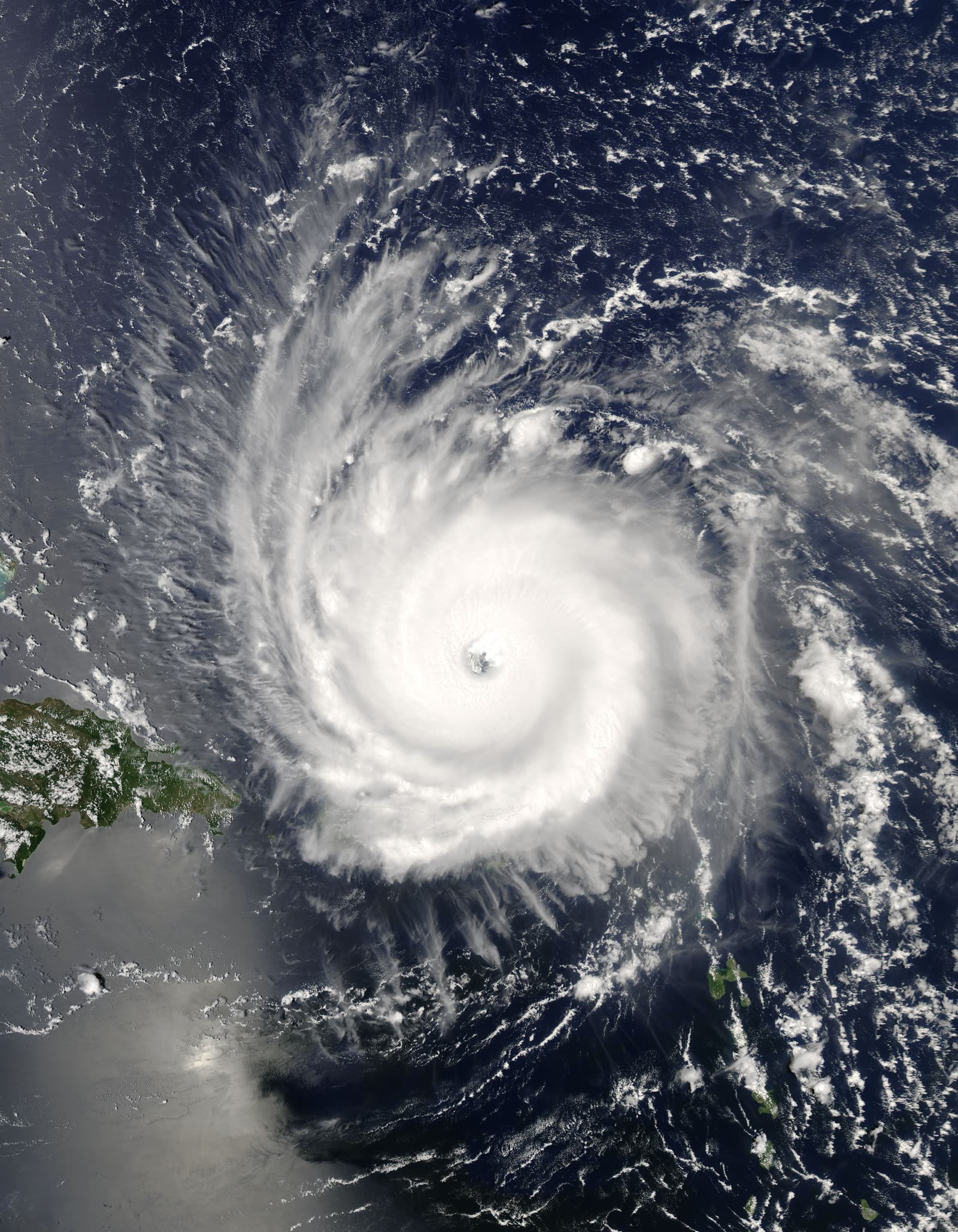
Frances at Category 4 peak intensity north of Puerto Rico, August 31, 2004
STORM ARCHIVE / 2004 LANDFALL 27.2°N 80.2°W
CAT 2 AT LANDFALL PEAK CAT 4 FL & SC · 2004 · 145 mph

Hurricane Frances

Landfall: Hutchinson Island, FL (near Stuart); 2nd landfall Big Bend near Aucilla River · 2004-09-05. Thousands of Charley-hit homes owed a second hurricane deductible three weeks later — the outcry produced Florida's single-season deductible law

NASA / GSFC (MODIS Rapid Response)
AT LANDFALL
CAT 2
PEAK INTENSITY
CAT 4 · 145 mph
PRESSURE
960 mb
STORM SURGE
5.89 ft
DAMAGE
~$9.5B
DEATHS
7
01 THE PATH

Where it hit, start to finish

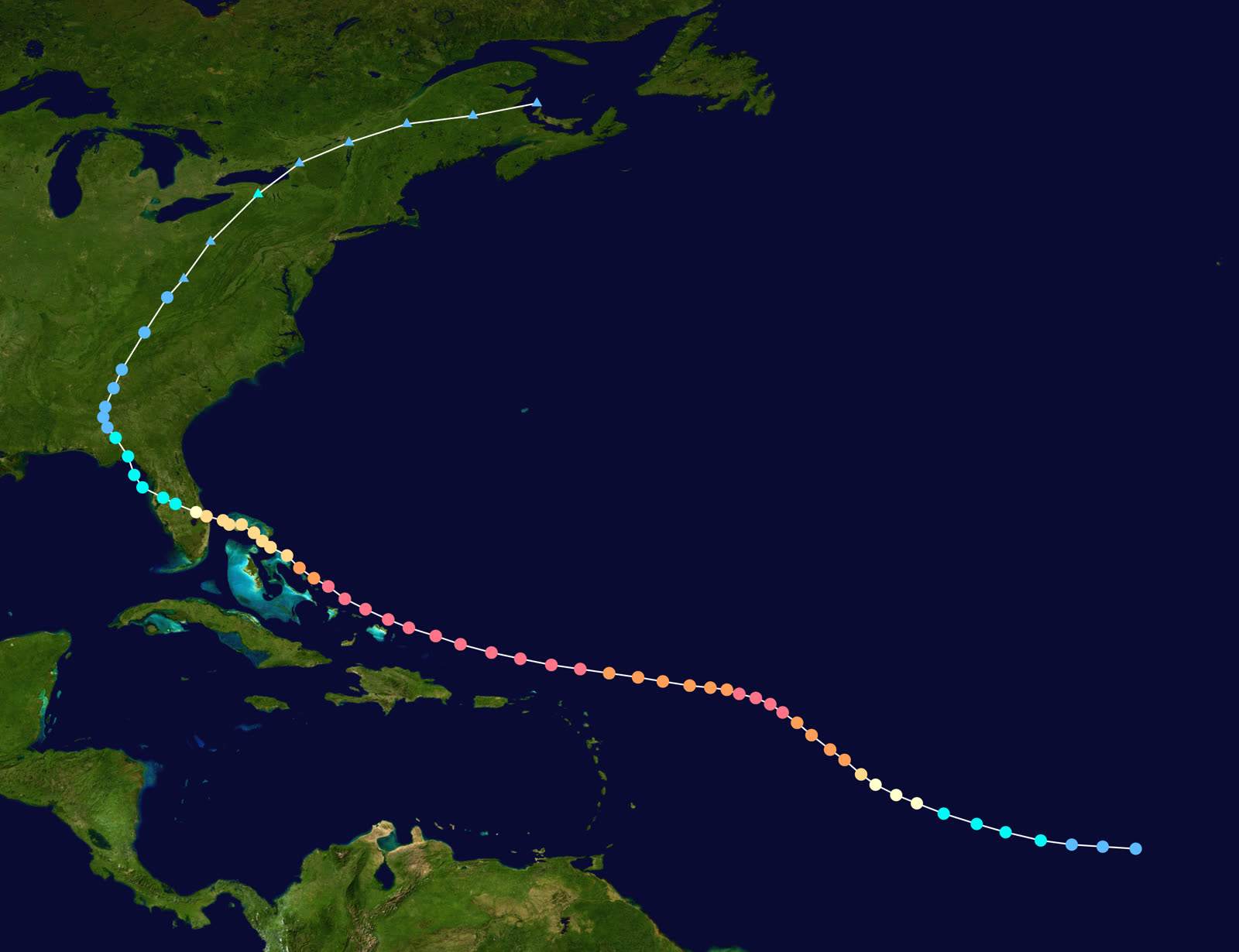
TRACK · HURRICANE FRANCESNOAA / NHC (best-track data)
Best track and Saffir-Simpson intensity of Hurricane Frances, August 24 – September 8, 2004
Bahamas
CAT 4 PEAK, THEN A CRAWL

Frances peaked at 145 mph and 935 mb, raked the Bahamas — surge flooded the airports at Freeport and Marsh Harbour — then slowed to a crawl as shear weakened it approaching Florida.

Treasure Coast, FL
LARGEST FL EVACUATION TO DATE

With a wind field vastly larger than Charley's, 2.8 million people across 41 counties were ordered out — at the time the largest evacuation in Florida history.

Hutchinson Island, FL
CAT 2 LANDFALL — HOURS OF POUNDING

Landfall at 0430 UTC September 5 at the island's southern end near Stuart: 105 mph, 960 mb. Moving at barely walking speed, Frances battered Martin, St. Lucie, Indian River, and Palm Beach counties for the better part of a day. Measured surge reached 5.89 ft at the St. Lucie Lock; NWS estimated 8 ft near Vero Beach.

Central Florida
4.2 MILLION WITHOUT POWER

Frances crossed the peninsula as a weakening, rain-heavy storm; over 73,000 Florida homes were damaged and 4.2 million customers lost power — many for a week or more, stacking spoilage and living-expense losses on top of wind claims.

Big Bend, FL
SECOND LANDFALL

After exiting into the Gulf, Frances made a final landfall near the Aucilla River mouth about 1800 UTC September 6 as a tropical storm, spreading rain across the Panhandle.

Carolinas / Appalachians
TORNADOES AND MOUNTAIN FLOODS

Frances spawned 101 US tornadoes — 45 in South Carolina on September 7, a state daily record — and dumped up to 23.57 in of rain at Mount Mitchell, NC. US total: ~$9.5B damage, 7 direct deaths.

02 THE RECORD IN IMAGES
ALL IMAGERY U.S. GOV / PUBLIC DOMAIN
DAMAGE FEMA / Mark Wolfe
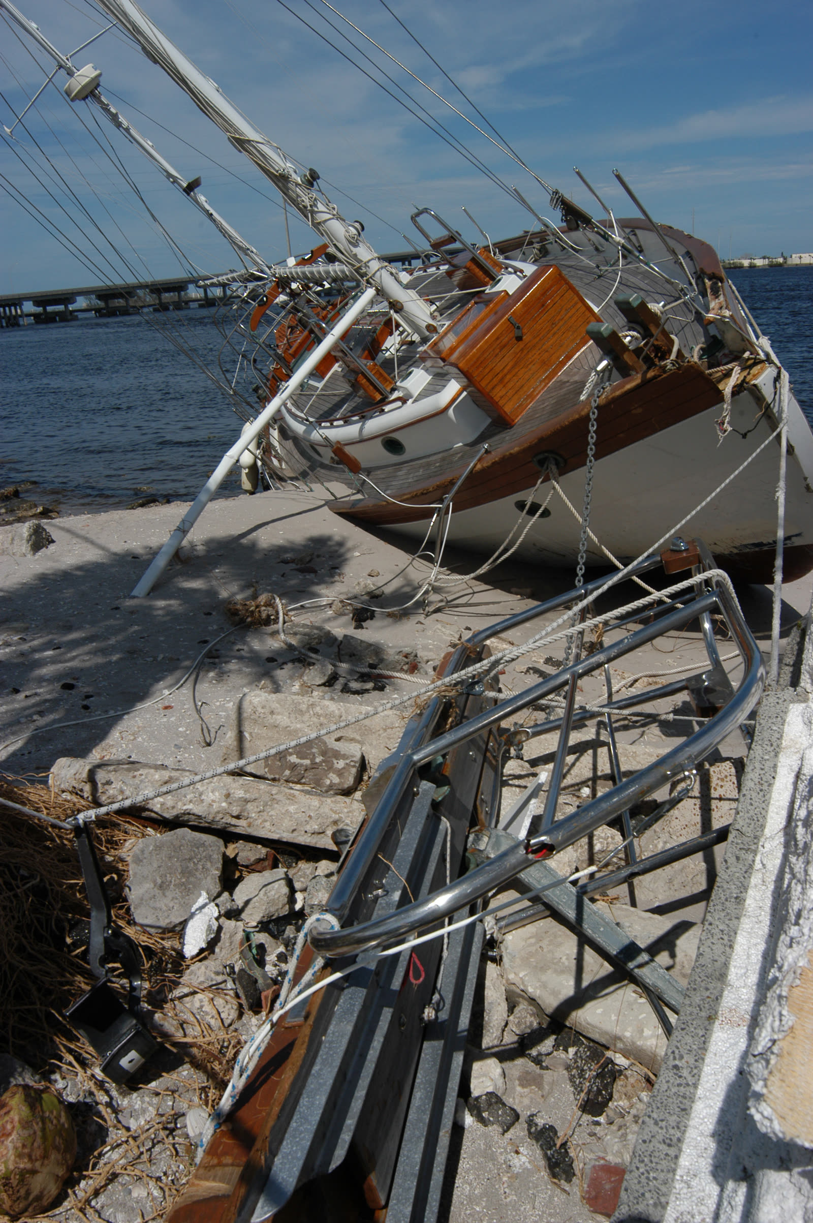
Ship wrecked by Frances at Fort Pierce, just north of the Hutchinson Island landfall point
DAMAGE FEMA / Andrea Booher
Church destroyed by Frances in Sebastian, on the Treasure Coast
DAMAGE NASA
Kennedy Space Center's Vehicle Assembly Building stripped of exterior panels — the space center reported over $100 million in damage
MAP NOAA / WPC (David Roth)
US rainfall from Frances — up to 23.57 in fell at Mount Mitchell, NC, driving inland flooding

The storm

Frances was everything Charley was not: huge, slow, and wet. A Cape Verde hurricane, it peaked at Category 4 — 145 mph, 935 mb — north of Puerto Rico at the end of August 2004, then plowed through the Bahamas, where surge inundated the airports at Freeport and Marsh Harbour.

Shear took the edge off before Florida. Frances made landfall at the southern end of Hutchinson Island near Stuart at 0430 UTC on September 5 as a Category 2 — 105 mph, 960 mb — just three weeks after Charley and, it would turn out, three weeks before Jeanne hit the same island. Its forward speed was the story: barely 5 mph at the coast, which meant the Treasure Coast took tropical-storm and hurricane-force winds for the better part of a day. The highest measured surge was 5.89 feet at the St. Lucie Lock, with NWS estimates near 8 feet at Vero Beach. Frances crossed the peninsula, re-emerged in the Gulf, and made a second landfall near the Aucilla River in the Big Bend on September 6 as a tropical storm. It then spawned 101 tornadoes on the way north — 45 in South Carolina on September 7 alone, a state daily record — and dropped up to 23.57 inches of rain at Mount Mitchell, North Carolina.
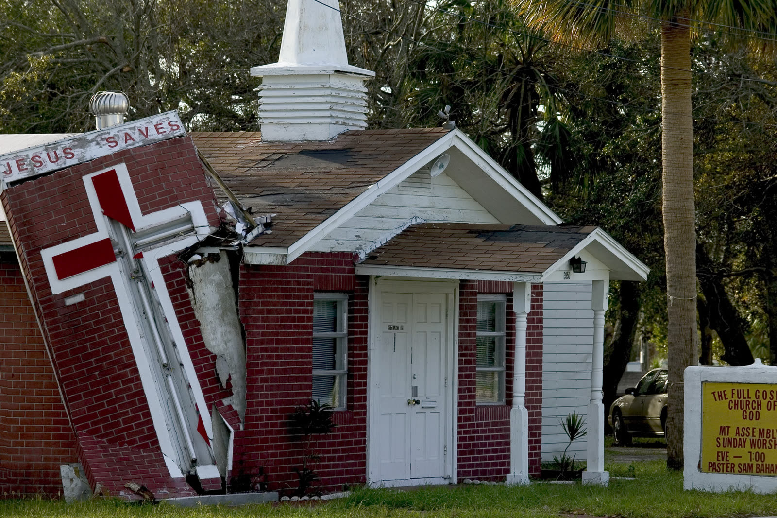
Church destroyed by Frances in Sebastian, on the Treasure Coast
Church destroyed by Frances in Sebastian, on the Treasure Coast FEMA / Andrea Booher

The damage

Duration, not peak wind, drove the losses. Hours of pounding worked shingles loose, then let wind-driven rain into attics and interiors — the classic Frances claim was a roof that "survived" but a house that soaked. More than 73,000 Florida homes were damaged and 4.2 million customers lost power. Kennedy Space Center reported over $100 million in damage, including hundreds of panels stripped from the Vehicle Assembly Building. Total US damage: about $9.5 billion nominal, with insured losses of $4.43 billion ($4.11 billion in Florida). Seven direct US deaths.
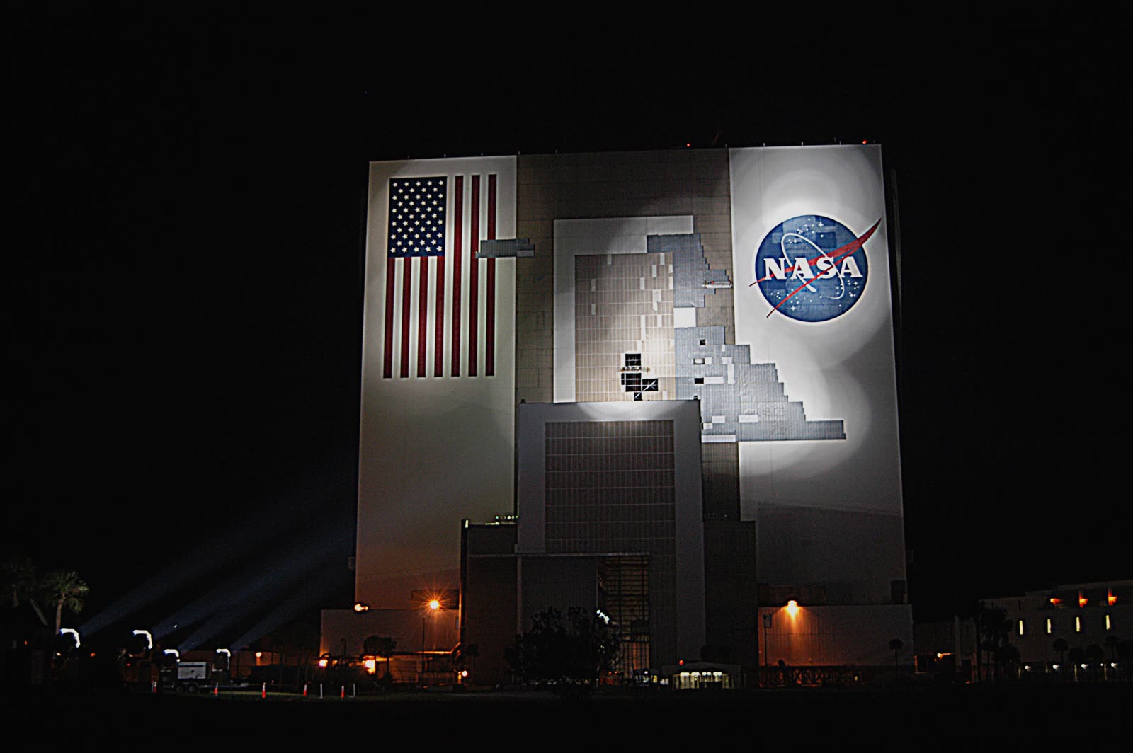
Kennedy Space Center's Vehicle Assembly Building stripped of exterior panels — the space center reported over $100 million in damage
Kennedy Space Center's Vehicle Assembly Building stripped of exterior panels — the space center reported over $100 million in damage NASA

The insurance aftermath

Frances turned the 2004 season from a disaster into a policy crisis, because it was the second storm. Percentage-based hurricane deductibles — typically 2 to 5 percent of dwelling coverage — applied per occurrence. A Central Florida home clipped by Charley and soaked by Frances owed two deductibles; after Jeanne, many owed three. Thousands of families absorbed five figures in uncovered loss before their coverage paid a dollar.

The backlash was immediate. In a December 2004 special session, the Legislature passed chapter 2004-480, directing the Department of Financial Services to reimburse policyholders whose insurers applied more than one 2004 hurricane deductible — the amount unpaid due to the second or subsequent deductible, on application by March 1, 2005. In 2005 the fix was made permanent and prospective: Florida law moved to a single calendar-year hurricane deductible, so a policyholder hit by multiple storms in one season pays the hurricane deductible once (later storms in the season apply the smaller all-perils deductible).

Frances also produced a distinctive denial pattern: with wind speeds "only" Category 2, carriers attributed interior water damage to wear, deteriorated seals, or excluded flood rather than storm-created openings. Wind-driven-rain disputes from Frances previewed arguments that returned in every large Florida storm since. And because Jeanne re-crossed the same counties 21 days later, adjusters spent 2005 allocating damage between two storms on one roof — see the Jeanne dossier for how those comparative-causation fights ran.
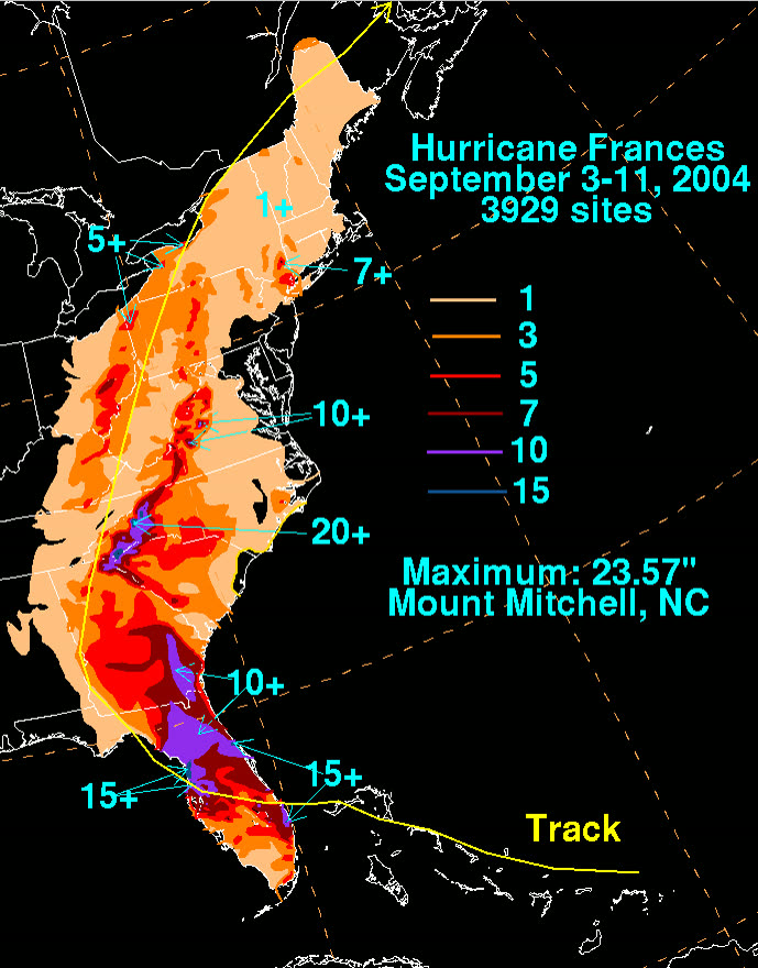
US rainfall from Frances — up to 23.57 in fell at Mount Mitchell, NC, driving inland flooding
US rainfall from Frances — up to 23.57 in fell at Mount Mitchell, NC, driving inland flooding NOAA / WPC (David Roth)

What policyholders learned

  • The season deductible rule exists because of this storm. Multi-storm homeowners who kept per-storm records — dates of loss, per-claim payments, deductible applications — recovered under the 2004 reimbursement program; the paperwork habit paid again in later seasons.
  • Duration damage is real damage. Long-duration Category 2 winds destroy roofs incrementally; owners who documented pre-storm roof condition beat "wear and tear" denials more often.
  • Interior water needs an opening story. Claims that identified the wind-created opening — lifted shingles, failed flashing, broken soffits — were paid; undifferentiated "water damage" claims were denied as flood or maintenance.
  • Power-out losses count. Food spoilage and additional living expenses during week-long outages were routinely under-claimed; policy sublimits applied but seldom zero.
  • Photograph between storms. Owners with dated photos after Frances but before Jeanne could prove which storm did what — the single most valuable piece of evidence in two-storm allocation disputes.

Independent informational resource — not legal advice. Damage figures are nominal (not inflation-adjusted) unless noted. Insurance-law summaries are drafted for education; consult an attorney about your specific claim.

AT LANDFALL · HURRICANE FRANCES · 2004
5.89 ft; est. 8 ft near Vero Beach
OF STORM SURGE · ST. LUCIE LOCK
HURRICANELAW.PRO FIELD FOOTAGE
03 THE FULL RECORD

Every official record of Frances

Reports, imagery archives, flood data, and claims records — straight from the agencies.

OUR LAW FIRM PARTNER · HALVERSEN LAW
Frances claim denied?
CALL FL941-390-3233CALL SC843-542-0454FREE CLAIM REVIEW
RELATED GUIDES
HurricaneLaw.Pro HURRICANELAW.PRO

The independent policyholder resource for Florida & South Carolina — storm archive, coverage law, denials, bad faith, and the complete claims playbook. 51 storms · 46 carriers · 97 public-adjuster firms · 37 city guides.

▸ SEE THE FULL SITE MAP — EVERY PAGE →
STORM ALERTS SOURCED FROM NOAA / NHC
SOUTH CAROLINA
496 Bramson Court, Suite 100
Mount Pleasant, SC 29464
CALL OR TEXT
FLORIDA
Tampa, FL
CALL OR TEXT
CLAIMS 9
DENIALS 8
BAD FAITH 7
COVERAGE 12
COMMERCIAL 8
ROOFS 8
TREES 5
DIRECTORIES
STORMS 51
WEATHER
NEWS & SITE 19
STORM ARCHIVE, CITIES & NEWS
Most recent below. Every storm dossier, city resource, and article is on its hub (linked at each heading) or the grouped site map →. All 46 carriers and 97 public-adjuster firms are in the Directories column above.
STORM ARCHIVE · 51 →
Hurricane Debby 2024Hurricane Helene 2024Hurricane Milton 2024Hurricane Idalia 2023Hurricane Ian 2022Hurricane Nicole 2022Hurricane Ida 2021Hurricane Laura 2020 View all 51 →
FLORIDA CITY RESOURCES · 29 →
Boca RatonBradentonCape CoralClearwaterDaytona BeachDestinFort LauderdaleFort Myers View all 29 →
SOUTH CAROLINA CITY RESOURCES · 8 →
BeaufortCharlestonColumbiaFlorenceGreenvilleHilton Head IslandMount PleasantMyrtle Beach
NEWS & UPDATES · 19 →

HurricaneLaw.Pro is an independent informational resource, not a law firm. Coverage summaries, policy-language quotations, dollar figures, deadlines, and chart examples throughout this site are general information based on typical or standard policy forms and are illustrative only — they are not a quote, a guarantee of coverage, or a promise of any outcome. Every insurance policy is different: your own policy, endorsements, and state law control, so read your policy and confirm current statutes. Weather imagery courtesy of NOAA, the National Hurricane Center, and the National Weather Service. Legal services are provided by our law firm partner, Halversen Law. Nothing on this site is legal advice; consult an attorney about your specific claim.

PrivacyTermsDisclaimerAboutContact
© 2026 HURRICANELAW.PRO — ALL RIGHTS RESERVED 27.9°N 82.5°W · ATLANTIC BASIN MONITOR
OUR LAW FIRM PARTNER
Halversen Law LICENSED · FLORIDA & SOUTH CAROLINA

All legal matters on this site are referred to and handled by our law firm partner, Halversen Law, a licensed law firm in Florida and South Carolina. HurricaneLaw.Pro is an informational resource and is not itself a law firm.

FREE CASE REVIEW