- •Homeowners insurance: no. Surge is "flood" under the water-damage exclusion, even though the wind pushed it.
- •Flood insurance: yes. NFIP covers surge, capped at $250K building / $100K contents, no living expenses, federal deadlines.
- •Private flood can go higher, replacement-cost contents, ALE, limits above the federal caps.
- •No flood policy = no coverage. FEMA grants and SBA loans are the only backstop, and they are not insurance.
- •Your surge risk is a public record: NOAA's SLOSH-based risk maps show how deep the water can get at your address.
What storm surge actually is
Storm surge is ocean water pushed ashore by a hurricane's wind field, stacked higher by low pressure and shaped by the shallow shelf it crosses. It is not a wall of water arriving once. It is the sea level itself rising, sometimes ten feet or more, with battering waves riding on top of the elevated surface. NHC treats it as the deadliest hazard a hurricane carries: roughly half of U.S. tropical-cyclone deaths historically come from surge, including most of Ian's 66 direct fatalities.
Surge behaves differently from every other hurricane peril. It is violently fast, Helene's water rose to rooftop level in minutes along the Big Bend. It is geographically merciless, a few blocks or a few feet of elevation separate a total loss from a dry floor. And its destructive power is not linear: water weighs 1,700 pounds per cubic yard, and moving water loads a wall like a slow-motion car crash. That physics is why the surge ladder below escalates so quickly from wet carpet to bare slab.
For insurance purposes, though, none of that matters. What matters is a single classification: rising water. The moment the ocean crosses your threshold, every policy in America calls it flood.
Why your homeowners policy will never cover it
The homeowners water-damage exclusion was drafted with surge specifically in mind. It does not stop at the word "flood". It enumerates every form the ocean can take on its way into your house, then adds the clause that closes the door on the "but the wind caused it" argument:
STANDARD HOMEOWNERS WATER-DAMAGE EXCLUSION (ISO HO-3 FORM, TYPICAL WORDING)"Water Damage means: Flood, surface water, waves, including tidal wave and tsunami, tides, tidal water, overflow of any body of water, or spray from any of these, all whether or not driven by wind…"
"Whether or not driven by wind" is the load-bearing phrase. Storm surge is, physically, wind-driven ocean, and the exclusion anticipates exactly that argument and forecloses it. The Fifth Circuit confirmed the reading in Leonard v. Nationwide after Katrina, and no court has seriously reopened it since. There is no endorsement, rider, or premium that puts surge back into a standard homeowners policy. The only instrument that covers rising ocean water is a flood policy.
Note what the exclusion does not reach: damage the wind did before the water arrived, and rain that entered through wind-created openings. A coastal house hit by both perils has two claims under two policies, and an allocation fight this site covers in its own guide to the causation war.
What does cover surge: NFIP vs. private flood
Flood insurance comes in two forms, and for surge losses the differences are not cosmetic. They decide whether a destroyed house is a covered loss or a capped one.
For a modest inland flood, the NFIP's caps rarely bind. For coastal surge they bind constantly: a waterfront home worth $600,000, used here only as an example. That takes six feet of water recovers the NFIP's $250,000 building cap and hunts for the rest, excess private flood if it was bought, the wind policy for any wind-caused share of the loss, and FEMA/SBA programs after that. The 30-day NFIP waiting period is the other structural trap: flood coverage cannot be bought when a storm is already on the map. The decision is made in May or not at all. Our flood coverage guide walks the full purchase decision.
The surge ladder: what each foot of water does
Damage from surge escalates by the foot, not by the storm category, which is why NHC abandoned tying surge forecasts to the Saffir-Simpson scale. Read the ladder bottom-up, the way the water arrives:
The surge ladder
Read bottom-up, the way the water arrives. Every rung includes everything below it, and waves riding on top multiply the damage. Bar length is peak depth above ground.
Every rung of this ladder is excluded from homeowners coverage. The only question is which flood policy, if any, responds.
Depth-damage progression drawn from NOAA/NHC surge guidance and FEMA depth-damage relationships. Storm anchors: NHC TCRs, Ian (10-15 ft peak inundation), Katrina (24-28 ft MS coast).
Look up your surge zone before the season does it for you
NOAA models surge with SLOSH: Sea, Lake and Overland Surges from Hurricanes, running thousands of hypothetical storms against each coastal basin's actual bathymetry. The composite "maximum of maximums" runs are published as the National Storm Surge Risk Maps: for any address on the Gulf or Atlantic coast, they show how deep the water could get, in feet above ground, for each hurricane category. Fifteen minutes with three free maps answers the question this whole page turns on:
- NHC surge risk map, open nhc.noaa.gov/nationalsurge ↗, zoom to your address, and step through categories 1-5. The color at your roof is your potential inundation depth. Compare it to the ladder above.
- Your evacuation zone, surge-based zones (A, F in most Florida counties) at Know Your Zone (FL) ↗ or SCEMD (SC) ↗. This is the map officials will use to order you out.
- Your FEMA flood zone, msc.fema.gov ↗ for the zone that drives flood-insurance pricing and mortgage requirements.
The three maps answer three different questions, how deep, when to leave, and what insurance costs, and they disagree constantly. The most expensive misreading in hurricane country is treating a FEMA "X zone" as proof of safety: FEMA maps statistical riverine and coastal flood frequency, not SLOSH surge reach. Whole neighborhoods flooded by Ian and Helene sat outside mapped high-risk flood zones, and most had declined flood insurance for exactly that reason. If the surge map shows water at your address at any category, the flood-policy decision is already made.
When wind and surge hit the same house
Everything above assumes the damage is cleanly surge. On a real coastline it rarely is: hurricane-force wind arrives hours before peak water, and by the time the surge recedes, one house holds two intertwined losses, one covered by the wind policy, one by the flood policy, each carrier pointing at the other. Anti-concurrent- causation clauses, burden-of-proof rules from the Katrina cases, slab-case reconstruction, the Ian jury verdicts. That is the causation war, and it has its own full guide: Surge vs. flood, who pays for the water?
The coverage takeaway belongs here: file both claims, immediately, regardless of what any adjuster says about which peril "really" caused the loss. The wind claim preserves the covered-peril side of the house; the flood claim preserves the capped-but-certain side. Letting either file close because "the other policy handles it" is how insured losses become uninsured ones.
Documenting a surge loss
A surge claim is documentation-driven twice over: NFIP claims have no bad-faith backstop. They are won on the file or not at all, and any wind-allocation argument depends on evidence gathered before cleanup destroys it. The sequence:
- Photograph the waterline first, every exterior wall, every interior room, with a tape measure in frame. The line establishes maximum water depth; damage above it belongs to the wind claim.
- Shoot before you gut, flooded drywall and flooring must come out fast to control mold, but the NFIP adjuster needs to see the loss. Wide-mid-close coverage of every room per the photo protocol, then cut. Keep material samples (flooring, carpet, drywall) if removal can't wait.
- Inventory contents as you carry them out, photograph each item, note make/model, don't discard anything an adjuster hasn't seen or you haven't photographed.
- Capture the sequence evidence, timestamps on security-camera and phone footage, when power failed, when water rose. If wind damage preceded the water, this is the allocation case.
- Hit the federal deadlines, NFIP: sworn proof of loss within 60 days; appeal within 60 days of denial; federal suit within 1 year of first denial. Calendar all three the week of the loss.
Katrina, Ian, Helene: three storms, one lesson
Katrina, 2005, the exclusion stress-tested. Surge of 24-28 feet on the Mississippi coast, the U.S. record, scraped blocks to their slabs and produced the largest NFIP payout in history: $16.3 billion, a debt the program has carried since. Katrina's litigation confirmed the surge exclusion (Leonard), created the modern causation doctrines, and exposed the structural conflict of carriers adjusting both the wind policy and the federally backed flood policy on the same house.
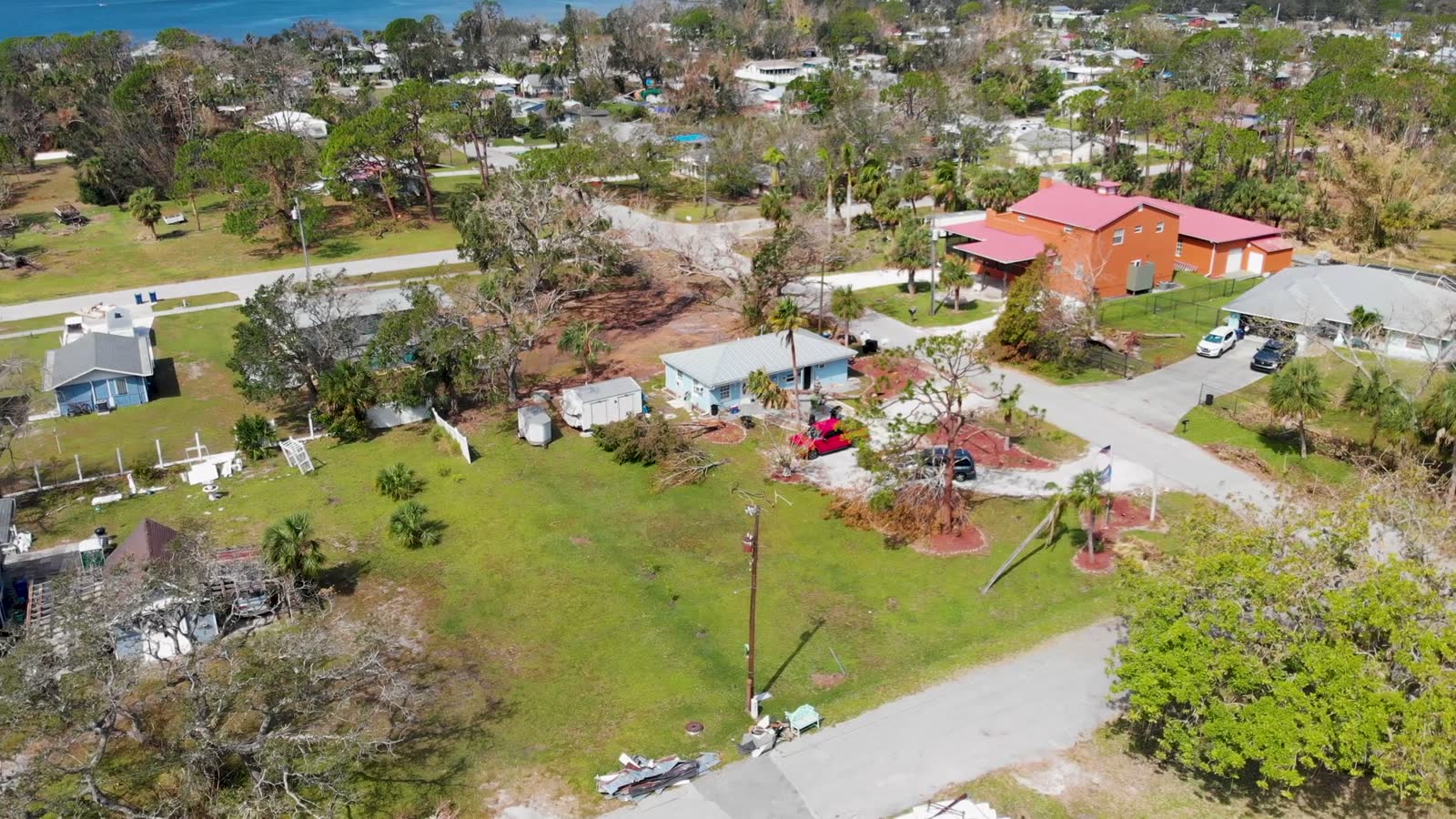
Ian, 2022, the caps stress-tested. 10-15 feet of inundation across Fort Myers Beach, Sanibel, and Estero Island; $112.9 billion in damage; most of the storm's 66 direct deaths by surge drowning. On the barrier islands, NFIP-insured owners collected their $250,000 and faced rebuild costs multiples higher; uninsured owners faced the exclusion with nothing behind it. Roughly 28 percent of residential claims closed without payment, and the wind-vs-surge allocation fights went to Lee County juries.
Helene, 2024, the gap stress-tested. Up to 15 feet of surge into the Big Bend, record water in Tampa Bay neighborhoods that hadn't flooded in living memory, and a flood-insurance take-up rate that collapsed inland. Of the Helene, Milton claim wave, 42 percent of residential claims closed without payment, with damage below the deductible and uncovered flood damage the leading cited reasons. Helene is the current, definitive argument for reading the SLOSH map before the season instead of the denial letter after it.
Florida vs. South Carolina
- Surge exposure: the nation's largest, shallow shelves on both coasts amplify surge from the Keys to the Big Bend; Ian, Helene, and Milton all fought surge allocation here within three seasons.
- Zone lookups: statewide "Know Your Zone" evacuation zones (A, F, surge-based); NHC risk maps cover both coasts.
- Flood market: largest NFIP book in the nation plus a fast-growing admitted private flood market, comparison shopping is realistic here.
- Wind-side deadlines (for the allocation fight): 1 year notice / 18 months supplemental (§ 627.70132); pay-or-deny in 60 days (§ 627.70131). NFIP deadlines are federal and unchanged by state law.
- Surge exposure: Hugo's 19.8 ft at Bulls Bay (1989) remains the state benchmark; Ian's third landfall at Georgetown pushed surge into the Charleston-to-Myrtle Beach coast in 2022.
- Zone lookups: SCEMD "Know Your Zone" evacuation zones for the eight coastal counties; NHC risk maps cover the coast.
- Flood market: NFIP-dominated; coastal households often stack three policies, homeowners (wind excluded), wind pool, flood, and surge losses land on the third.
- Wind-side deadlines: "prompt" notice per policy; 3-year contract suit period; § 38-59-20 improper-claims-practices law as the conduct backstop. NFIP deadlines are federal.
Statutes and deadlines summarized as of July 2026. NFIP rules are federal and identical in both states. Verify against your policy and current statute.
Storm surge coverage, the questions everyone asks
Is storm surge covered by homeowners insurance?
No. Every standard homeowners policy excludes water damage from flood, and the exclusion defines flood to include waves, tidal water, storm surge, and overflow of any body of water, whether or not driven by wind. Courts, including the Fifth Circuit in Leonard v. Nationwide, have upheld that reading. It does not matter that a hurricane, a covered wind event, pushed the water.
What insurance does cover storm surge?
Flood insurance. An NFIP policy covers surge as flood, up to $250,000 for the building and $100,000 for contents, with no additional-living-expense coverage. Private flood policies, a growing market, especially in Florida, can offer higher limits, replacement-cost contents, and ALE. If you carry neither, surge damage is uninsured, and recovery is limited to FEMA grants and SBA disaster loans.
Is storm surge the same thing as flood for insurance purposes?
Yes. That is the whole trick. Meteorologically, surge is ocean water driven ashore by a hurricane’s wind and pressure; a river flood is rainfall runoff. Insurance policies collapse the distinction: both are "flood," excluded from homeowners coverage and covered by flood policies. The NFIP does not care whether the water came from the Gulf or the river, only that it was general, temporary inundation of normally dry land.
How do I find out my storm surge risk?
Three lookups, all free. First, NOAA’s National Storm Surge Risk Maps, built from thousands of SLOSH model runs, show potential inundation depth at your address by hurricane category. Second, your county’s evacuation zone map (surge-based zones A through F in most of Florida) tells you when officials expect the water to reach you. Third, FEMA’s flood map service center gives your flood zone, which drives insurance pricing. The critical point: these are three different maps. Being outside a FEMA flood zone does not mean you are outside the surge zone.
I’m not in a FEMA flood zone. Can I skip flood insurance?
You can, nothing requires it without a federally backed mortgage in a Special Flood Hazard Area, but the surge record argues against it. FEMA flood zones map long-term statistical risk, not hurricane surge reach; large shares of the homes flooded by Ian’s surge and Helene’s inundation sat outside mapped high-risk zones, and most carried no flood policy. NFIP policies are available in almost every community regardless of zone, are cheaper outside high-risk zones, and carry a 30-day waiting period, the reason to decide before a storm has a name.
Both wind and surge hit my house. Which policy pays?
Potentially both, the homeowners policy for what the wind did, the flood policy for what the water did. Allocation between them is the "causation war": each carrier has an incentive to attribute damage to the other policy’s peril, anti-concurrent-causation clauses complicate mixed damage, and sequence evidence decides. File both claims immediately and read our surge-vs-flood fight guide. It is the deepest page on this site for a reason.
What deadlines apply to an NFIP surge claim?
Federal ones, strictly enforced: a signed, sworn proof of loss within 60 days of the loss (FEMA sometimes extends after major storms), an appeal to FEMA within 60 days of a written denial, and suit in federal district court within one year of the first written denial. State deadlines and bad-faith remedies do not apply to NFIP claims.
- NOAA / NHC National Storm Surge Risk Maps (SLOSH MOMs) ↗
- NOAA / NHC Introduction to storm surge (PDF) ↗
- NOAA / NHC SLOSH model overview ↗
- NOAA / NHC NHC Tropical Cyclone Report, Hurricane Katrina (PDF) ↗
- NOAA / NHC NHC Tropical Cyclone Report, Hurricane Ian (PDF) ↗
- NOAA / NHC NHC Tropical Cyclone Report, Hurricane Helene (PDF) ↗
- FINDLAW Leonard v. Nationwide Mut. Ins. Co., 499 F.3d 419 (5th Cir. 2007) ↗
- FEMA NFIP Claims Handbook (PDF) ↗
- FEMA FEMA Flood Map Service Center ↗
- FDEM Florida Division of Emergency Management, Know Your Zone ↗
- SCEMD SC Emergency Management Division, hurricane evacuation zones ↗
- USGS USGS Flood Event Viewer, high-water marks ↗
- FLOIR FLOIR Hurricane Ian catastrophe claims data ↗
Not legal advice; consult an attorney about your specific claim. Surge figures from NHC Tropical Cyclone Reports; claim statistics as reported in FLOIR catastrophe data releases.
Surge is water, and water is a separate policy
Storm surge is ocean water driven inland by hurricane wind. Standard homeowners policies exclude flood, and the policy language defines flood to include surge from a named storm. That water is covered only by a separate flood policy, through the NFIP or a private carrier. A home with no flood policy collects nothing for surge, no matter how high the water rose. The homeowners policy still answers for wind: torn roofs, broken windows, and the wind-driven rain that entered through those openings before the water reached the structure.
Most disputes turn on which force did the damage. Carriers routinely assign the entire loss to surge, because surge sits outside the policy they wrote, then deny. The counter is sequence and elevation: what the wind opened first, how high the water reached, and which items sat above the surge line, the exact ground covered in surge versus flood denials. Separating the wind and water claims early keeps the wind loss from being folded into a denied flood file; the split is laid out on wind and hurricane coverage, and the weather center ties wind field and surge data to the storm that hit your address. If your surge claim was denied or paid short, document photos, elevation notes, and water lines, work the claims steps, and let a licensed public adjuster price the loss. Start with the free review below.
Surge loss bigger than the check? Find out what's left.
Upload the flood adjuster's estimate and your photos. You'll get a straight answer on whether the NFIP payout is right, whether a wind claim is being left on the table, and what deadlines are already running.

 HURRICANELAW.PRO
 A comprehensive property-insurance claim resource for policyholders: denied and underpaid claims, coverage and bad-faith law, storm dossiers, carrier profiles, city guides, and the complete claims playbook. Florida and South Carolina.
▸ SEE THE FULL SITE MAP →Coverage summaries, policy-language quotations, dollar figures, deadlines, and chart examples throughout this site are general information based on typical or standard policy forms and are illustrative only: they are not a quote, a guarantee of coverage, or a promise of any outcome. Every insurance policy is different: your own policy, endorsements, and state law control, so read your policy and confirm current statutes. Weather imagery courtesy of NOAA, the National Hurricane Center, and the National Weather Service. Legal services are provided by Halversen Law. Nothing on this site is legal advice; consult an attorney about your specific claim.
Legal matters are handled by Halversen Law, a law firm licensed in Florida and South Carolina.