
PROPERTY-INSURANCE CLAIM HELP · FL & SC FL CITIESSC CITIESGUIDESTATESNEWSSITE MAPABOUT
HurricaneLaw.Pro HURRICANELAW.PRO
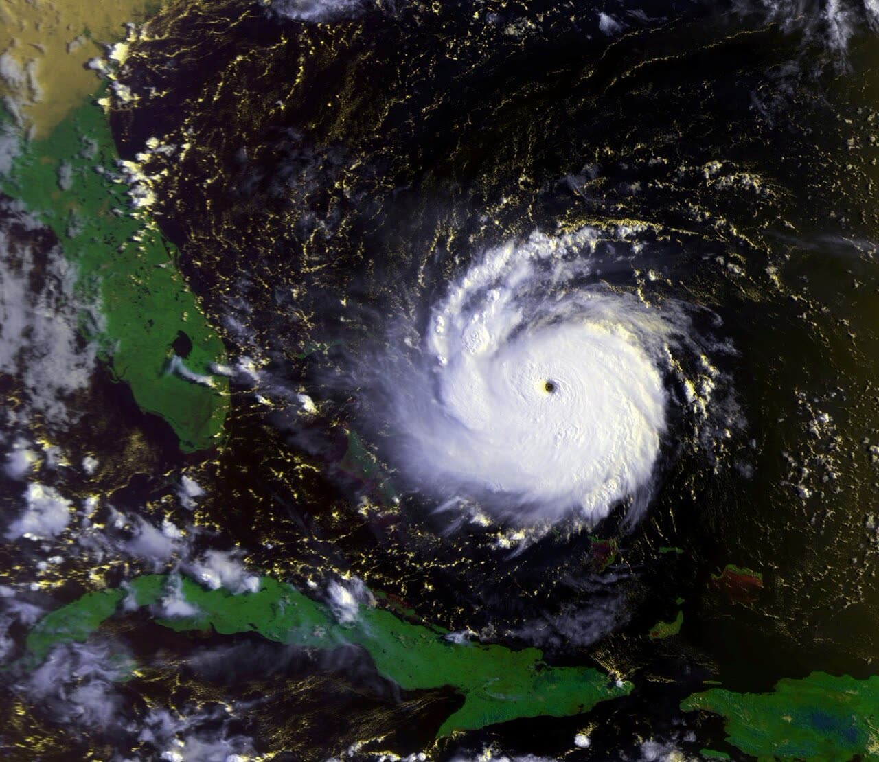
Andrew bearing down on the Bahamas at Category 5 strength, August 23, 1992
STORM ARCHIVE / 1992 LANDFALL 25.5°N 80.3°W
CAT 5 FL · 1992 · 175 mph

Hurricane Andrew

Landfall: Homestead / Florida City, FL · 1992-08-24. Bankrupted at least 8 insurers and forced Florida to invent its modern insurance system — the Cat Fund, the state-run insurer that became Citizens, and the statewide building code.

NOAA / NESDIS
AT LANDFALL
CAT 5
PEAK WIND
175 mph
PRESSURE
922 mb
STORM SURGE
16.9 ft
DAMAGE
$27.3B
DEATHS
65
01 THE PATH

Where it hit, start to finish

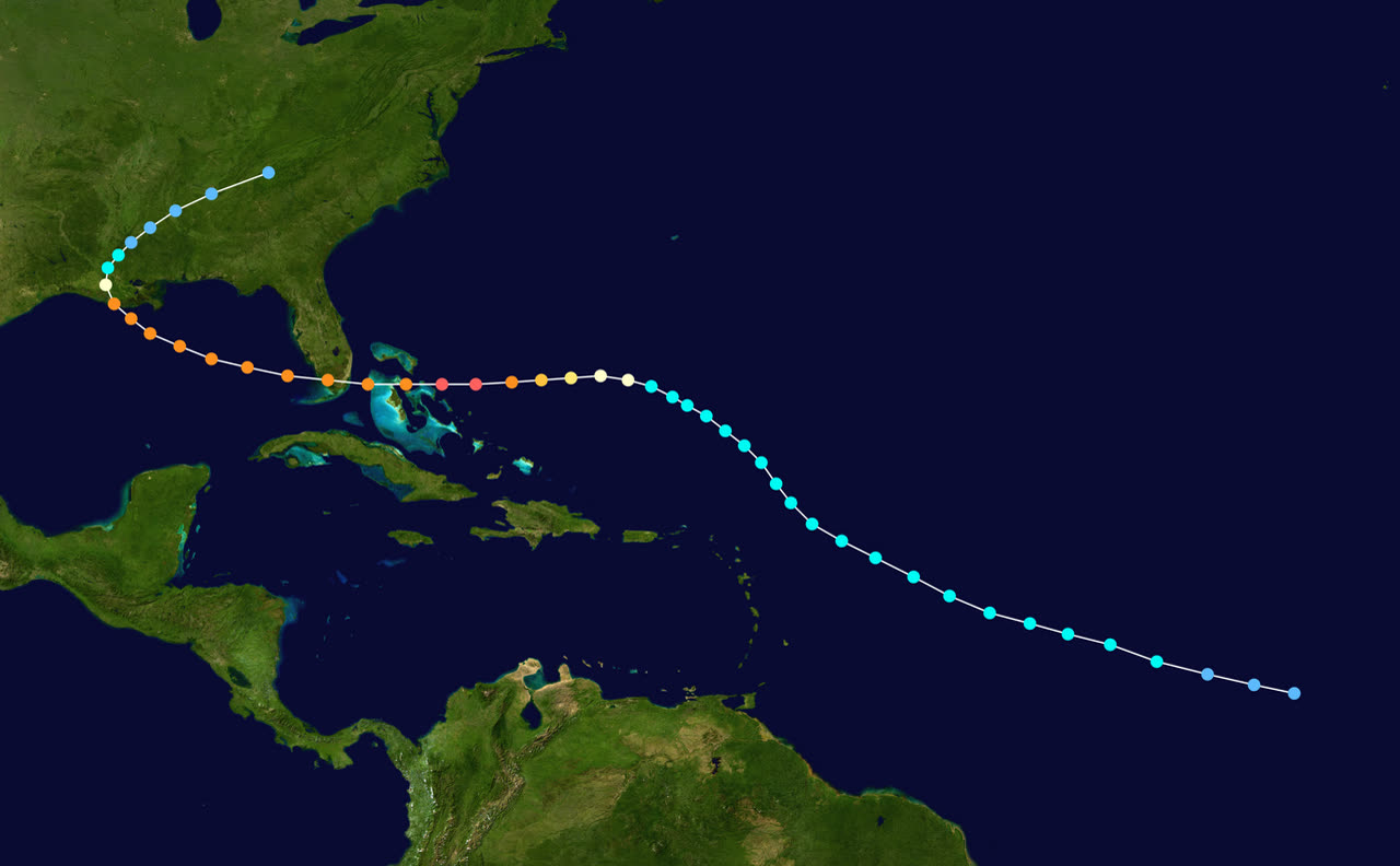
TRACK · HURRICANE ANDREWNOAA / NHC best-track data
Best track of Hurricane Andrew, August 16-28, 1992 — Bahamas, South Florida, and Louisiana landfalls
Eleuthera, Bahamas
CAT 5 STRIKE · AUG 23

Andrew crossed Eleuthera and the Berry Islands near peak intensity with winds around 160 mph — four deaths and roughly $250 million in damage in the Bahamas.

Homestead / Florida City, FL
CAT 5 LANDFALL · 165 MPH · AUG 24

Landfall at 922 mb, the third-lowest U.S. landfall pressure then on record. About 25,500 houses destroyed and 101,000+ damaged in Dade County; 1.4 million customers lost power.

Biscayne Bay, FL
16.9 FT SURGE — FLORIDA RECORD

Surge peaked at 16.9 ft at the head of Biscayne Bay. The destructive core was only 25-30 miles wide and crossed the peninsula in about four hours.

Gulf of Mexico
RE-INTENSIFICATION · AUG 25

Andrew regained Category 4 intensity over the warm Gulf and damaged offshore oil-and-gas platforms on its way to a second U.S. landfall.

South-central Louisiana
2ND LANDFALL · CAT 3 · 115 MPH · AUG 26

Came ashore in the sparsely populated Atchafalaya marsh region; roughly $1 billion in Louisiana damage, heavy crop losses, and a tornado in LaPlace that killed two.

Mid-South / Mid-Atlantic
DISSIPATION · AUG 27-28

Weakened rapidly inland, spawning tornadoes across the Gulf states before merging with a frontal system over the mid-Atlantic.

02 THE RECORD IN IMAGES
ALL IMAGERY U.S. GOV / PUBLIC DOMAIN
SATELLITE NOAA
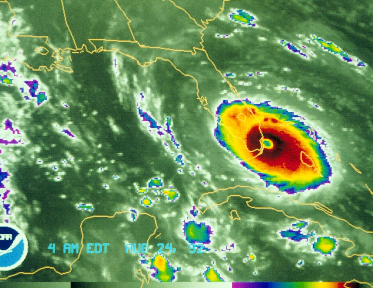
Satellite view of Andrew making landfall south of Miami, about 5 a.m. August 24, 1992
SATELLITE NASA
Three-frame composite of Andrew: over the Bahamas, at Florida landfall, and in the Gulf, August 23-25, 1992
SATELLITE NOAA / GOES-7
Andrew re-intensifying in the Gulf of Mexico en route to Louisiana, August 25, 1992
AERIAL FEMA
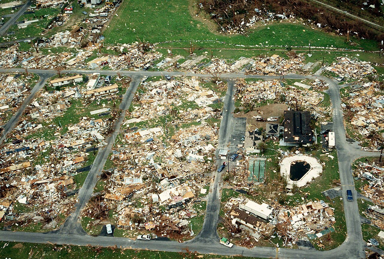
Aerial of flattened homes in southern Dade County — roughly 25,500 houses destroyed, 101,000+ damaged
DAMAGE FEMA
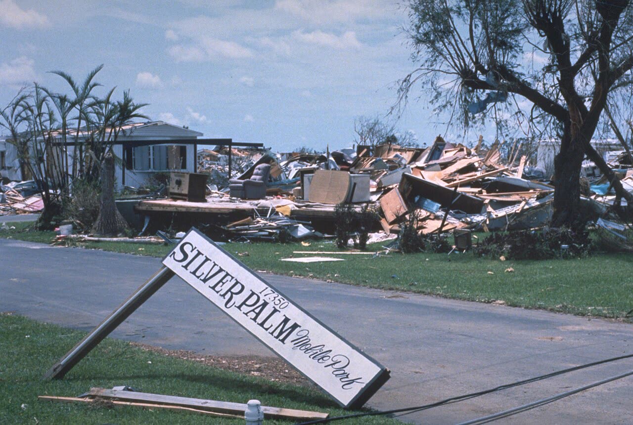
Silver Palm mobile home park, Miami-Dade — about 99 percent of Homestead's mobile homes were destroyed
DAMAGE FEMA
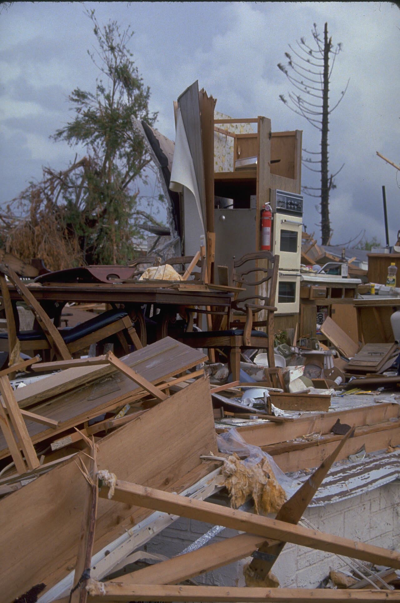
Wind-destroyed homes in the Homestead area — stapled roof sheathing failed first, then wind-driven rain gutted interiors
AERIAL U.S. DoD / National Archives
DoD aerial survey of a flattened neighborhood in the Homestead area — block after block reduced to debris fields

The storm

Andrew left the African coast as a tropical wave on August 14, 1992, and nearly died twice crossing a hostile Atlantic. On August 22 it found warm water and low shear east of the Bahamas and intensified from tropical storm to Category 4 in 36 hours.

It crossed the northern Bahamas, then struck the Florida coast near Homestead at about 5 a.m. on August 24. NOAA's 2004 reanalysis upgraded the landfall to Category 5 — sustained winds near 165 mph, gusts higher, central pressure 922 mb, the third-lowest U.S. landfall pressure on record at the time. Peak intensity was about 175 mph.

Andrew was compact and fast-moving. The destructive core was roughly 25–30 miles wide, and the storm crossed the peninsula in about four hours. Storm surge reached 16.9 ft at the head of Biscayne Bay — a Florida record at the time — but wind, not water, did most of the damage. Rainfall was modest for a major hurricane (generally under 8 inches) because of the storm's speed. Andrew went on to a second U.S. landfall in south-central Louisiana on August 26 as a Category 3.
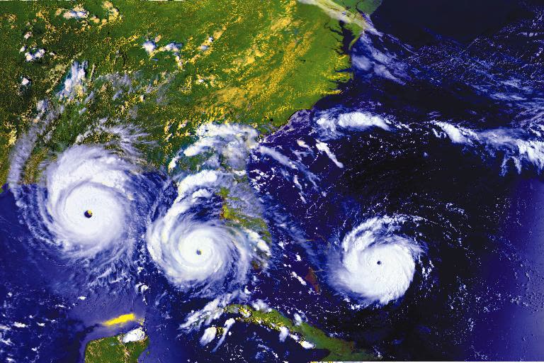
Three-frame composite of Andrew: over the Bahamas, at Florida landfall, and in the Gulf, August 23-25, 1992
Three-frame composite of Andrew: over the Bahamas, at Florida landfall, and in the Gulf, August 23-25, 1992 NASA

The damage

The wind field centered on Homestead, Florida City, and the Country Walk and Naranja areas of southern Dade County. Per the NHC preliminary report, roughly 25,500 houses were destroyed and more than 101,000 damaged in Dade County. About 99 percent of the mobile homes in Homestead were destroyed. Homestead Air Force Base was effectively leveled. Some 1.4 million customers lost power. Sixty-five deaths were attributed to the storm (26 direct).

The failure pattern became a national case study. Roof sheathing attached with staples instead of nails peeled off first; once the roof deck opened, wind-driven rain destroyed interiors and internal pressurization blew out gable ends and garage doors. Post-storm engineering surveys found widespread construction that did not meet the South Florida Building Code then on the books — a code-enforcement failure, not just a code failure. Unprotected windows and doors turned into breach points for debris.

Total damage: $27.3 billion nominal — the costliest U.S. natural disaster to that date.
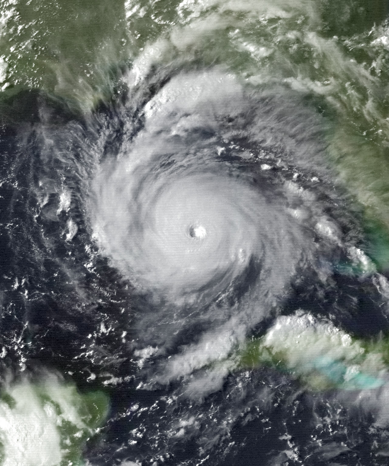
Andrew re-intensifying in the Gulf of Mexico en route to Louisiana, August 25, 1992
Andrew re-intensifying in the Gulf of Mexico en route to Louisiana, August 25, 1992 NOAA / GOES-7

The insurance aftermath

Insured losses reached $15.5 billion (Property Claim Services, nominal) on more than 650,000 claims — roughly four times what most insurers had modeled as their worst-case Florida hurricane. Before Andrew, no U.S. catastrophe had exceeded $5 billion insured.

The market broke. At least eight insurers became insolvent as a direct result — seven Florida-domiciled companies and one foreign insurer — and others survived only through capital transfers from parent companies. (Counts in later retrospectives range as high as eleven; the count depends on how "technically insolvent" carriers are treated.) The failed carriers left more than $400 million in unpaid claims to the Florida Insurance Guaranty Association, which had to double its assessment rate on surviving insurers to cover them.

Surviving carriers then tried to leave. Insurers announced plans to cancel or non-renew hundreds of thousands of Florida policies, and the state answered with a moratorium on mass cancellations. The structural fixes followed in rapid sequence:

  • 1993 — Florida Hurricane Catastrophe Fund (Fla. Stat. 215.555): state-run reinsurance backstop so carriers could buy hurricane cover the private reinsurance market was no longer willing to sell at pre-Andrew prices.
  • 1993 — residual market: the Florida Residential Property and Casualty Joint Underwriting Association was created for homeowners who could not find coverage; in 2002 it merged with the wind pool to form Citizens Property Insurance Corporation, still the state's insurer of last resort.
  • 2002 — statewide Florida Building Code, replacing the patchwork of local codes, with the strongest wind provisions in the country for the High-Velocity Hurricane Zone (Miami-Dade and Broward).

Andrew also created the modern catastrophe-modeling industry. Rating agencies and regulators began requiring model-based hurricane exposure management, and Florida established a state commission to certify the models used in rate filings.

For policyholders on the ground, the claims experience previewed every large Florida storm since: a shortage of adjusters, months-long waits, disputes over scope (full roof replacement vs. repair), and carriers that failed mid-claim, converting insurance claims into guaranty-association claims with statutory caps.
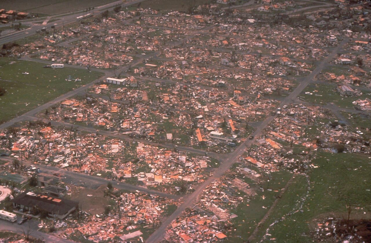
Aerial of flattened homes in southern Dade County — roughly 25,500 houses destroyed, 101,000+ damaged
Aerial of flattened homes in southern Dade County — roughly 25,500 houses destroyed, 101,000+ damaged FEMA

What policyholders learned

  • Insolvency risk is real. Policyholders of the eight failed carriers recovered through the guaranty association — slower, capped, and paperwork-heavy. Financial strength ratings became something Florida homeowners actually checked.
  • Code-upgrade costs were a fight. Rebuilding to current code cost more than like-for-like repair; policyholders without ordinance-or-law coverage absorbed the gap. The dispute pushed ordinance/law coverage into standard Florida policy discussions.
  • Scope disputes decided payouts. The recurring argument was repair vs. replace on roofs and interiors. Policyholders who obtained independent contractor estimates and engineering opinions — rather than accepting the carrier adjuster's scope — documented the larger losses.
  • Photo-and-inventory documentation won claims. With whole neighborhoods flattened, contents claims turned on pre-storm proof. Households with photos, receipts, or video of the home's contents settled faster and fuller than those reconstructing inventories from memory.
  • Underinsurance surfaced at the worst moment. Dwelling limits set years earlier didn't match 1992 reconstruction costs, and post-storm demand surge inflated those costs further. Replacement-cost adequacy became a standard annual policy-review item.
  • Adjuster churn hurt continuity. Files passed between out-of-state catastrophe adjusters. Policyholders who kept their own written log — every call, name, date, and promised action — could enforce commitments that otherwise disappeared between adjuster handoffs.

Independent informational resource — not legal advice. Damage figures are nominal (not inflation-adjusted) unless noted. Insurance-law summaries are drafted for education; consult an attorney about your specific claim.

AT LANDFALL · HURRICANE ANDREW · 1992
16.9 ft
OF STORM SURGE
HURRICANELAW.PRO FIELD FOOTAGE
03 THE FULL RECORD

Every official record of Andrew

Reports, imagery archives, flood data, and claims records — straight from the agencies.

OUR LAW FIRM PARTNER · HALVERSEN LAW
Andrew claim denied?
CALL FL941-390-3233CALL SC843-542-0454FREE CLAIM REVIEW
RELATED GUIDES
HurricaneLaw.Pro HURRICANELAW.PRO

The independent policyholder resource for Florida & South Carolina — storm archive, coverage law, denials, bad faith, and the complete claims playbook. 51 storms · 46 carriers · 97 public-adjuster firms · 37 city guides.

▸ SEE THE FULL SITE MAP — EVERY PAGE →
STORM ALERTS SOURCED FROM NOAA / NHC
SOUTH CAROLINA
496 Bramson Court, Suite 100
Mount Pleasant, SC 29464
CALL OR TEXT
FLORIDA
Tampa, FL
CALL OR TEXT
CLAIMS 9
DENIALS 8
BAD FAITH 7
COVERAGE 12
COMMERCIAL 8
ROOFS 8
TREES 5
DIRECTORIES
STORMS 51
WEATHER
NEWS & SITE 19
STORM ARCHIVE, CITIES & NEWS
Most recent below. Every storm dossier, city resource, and article is on its hub (linked at each heading) or the grouped site map →. All 46 carriers and 97 public-adjuster firms are in the Directories column above.
STORM ARCHIVE · 51 →
Hurricane Debby 2024Hurricane Helene 2024Hurricane Milton 2024Hurricane Idalia 2023Hurricane Ian 2022Hurricane Nicole 2022Hurricane Ida 2021Hurricane Laura 2020 View all 51 →
FLORIDA CITY RESOURCES · 29 →
Boca RatonBradentonCape CoralClearwaterDaytona BeachDestinFort LauderdaleFort Myers View all 29 →
SOUTH CAROLINA CITY RESOURCES · 8 →
BeaufortCharlestonColumbiaFlorenceGreenvilleHilton Head IslandMount PleasantMyrtle Beach
NEWS & UPDATES · 19 →

HurricaneLaw.Pro is an independent informational resource, not a law firm. Coverage summaries, policy-language quotations, dollar figures, deadlines, and chart examples throughout this site are general information based on typical or standard policy forms and are illustrative only — they are not a quote, a guarantee of coverage, or a promise of any outcome. Every insurance policy is different: your own policy, endorsements, and state law control, so read your policy and confirm current statutes. Weather imagery courtesy of NOAA, the National Hurricane Center, and the National Weather Service. Legal services are provided by our law firm partner, Halversen Law. Nothing on this site is legal advice; consult an attorney about your specific claim.

PrivacyTermsDisclaimerAboutContact
© 2026 HURRICANELAW.PRO — ALL RIGHTS RESERVED 27.9°N 82.5°W · ATLANTIC BASIN MONITOR
OUR LAW FIRM PARTNER
Halversen Law LICENSED · FLORIDA & SOUTH CAROLINA

All legal matters on this site are referred to and handled by our law firm partner, Halversen Law, a licensed law firm in Florida and South Carolina. HurricaneLaw.Pro is an informational resource and is not itself a law firm.

FREE CASE REVIEW