

PROPERTY-INSURANCE CLAIM HELP · FL & SC FL CITIESSC CITIESGUIDESTATESNEWSSITE MAPABOUT
HurricaneLaw.Pro HURRICANELAW.PRO
STORM ARCHIVE / 2024
CAT 3 AT LANDFALL PEAK CAT 5 FL · 2024 · 180 mph

Hurricane Milton

Landfall: Siesta Key, FL · 2024-10-09. Landed 13 days after Helene — insurers fought over which storm, and which policy, owed for the same house

STORM FOOTAGE
AT LANDFALL
CAT 3
PEAK INTENSITY
CAT 5 · 180 mph
DAMAGE
$34B
DEATHS
42
01 THE PATH

Where it hit, start to finish

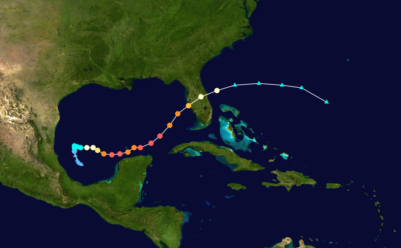
TRACK · HURRICANE MILTONNOAA / NHC best-track data
Best track of Hurricane Milton: southwestern Gulf → Siesta Key, FL → Atlantic exit
Southwestern Gulf of Mexico
RECORD INTENSIFICATION · 897 MB · 180 MPH

Milton spun up from formation on October 5 to a 180 mph Category 5 by October 7 — roughly a 90 mph jump in about a day, with an 897 mb central pressure among the lowest ever measured in the Atlantic basin.

St. Lucie County / Treasure Coast, FL
DEADLY TORNADO OUTBREAK · 45+ TORNADOES

Hours before landfall, Milton's outer bands spawned one of Florida's worst tornado outbreaks — 45+ confirmed tornadoes, including an EF3 that leveled homes at Spanish Lakes Country Club Village near Fort Pierce and killed six people on the coast opposite the landfall.

Siesta Key, FL
CAT 3 LANDFALL · 120 MPH · OCT 9

Wind shear weakened Milton on final approach; it came ashore at 8:30 PM EDT as a Category 3, driving 5–10 ft of surge into Sarasota and Charlotte county beach towns — 13 days after Helene, with flood debris still piled at the curb.

St. Petersburg / Tampa Bay, FL
100+ MPH GUSTS · 18+ IN RAIN

Milton shredded the roof of Tropicana Field, collapsed a construction crane, and dropped more than 18 inches of rain on St. Petersburg — while offshore winds blew the water out of Tampa Bay instead of into it.

Lakeland / Polk County, FL
INLAND FRESHWATER FLOODING

Rain-driven flooding inundated the Lake Bonny neighborhoods of Lakeland — outside FEMA-designated flood zones, where most homeowners carried no flood insurance.

Cape Canaveral / Atlantic exit
EXIT TO ATLANTIC · OCT 10

Still a hurricane, Milton raked the Space Coast at Category 1 strength and moved into the Atlantic. Totals: roughly $34 billion in damage and 42 deaths.

02 THE RECORD IN IMAGES
ALL IMAGERY U.S. GOV / PUBLIC DOMAIN
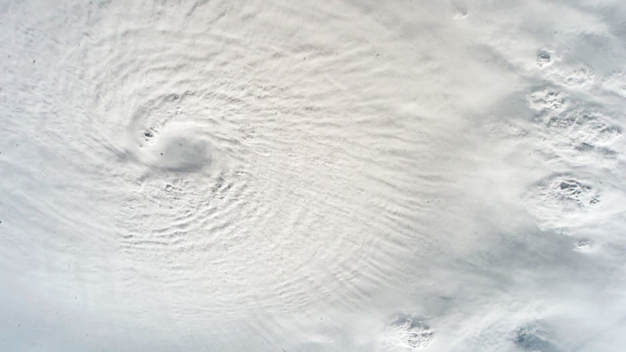
SATELLITE NASA
The eye of Category 5 Milton photographed from the International Space Station, October 7, 2024
CONE NOAA / NHC
NHC forecast cone, Advisory 19 — 5 PM EDT October 9, hours before Siesta Key landfall
RADAR NOAA / NWS
NWS Tampa Bay radar loop of Milton's Category 3 landfall near Siesta Key, night of October 9, 2024
MAP NOAA / SPC
SPC storm reports for October 9, 2024 — the deadly pre-landfall tornado outbreak across the peninsula
DAMAGE NOAA / NWS Miami
EF3 tornado damage in The Acreage, Palm Beach County — 100+ miles from Milton's landfall point
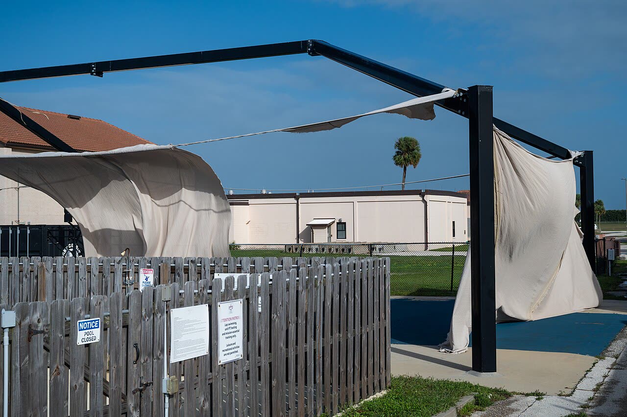
DAMAGE U.S. Space Force
Milton raking Patrick Space Force Base at Category 1 strength on its way out to the Atlantic, October 10, 2024
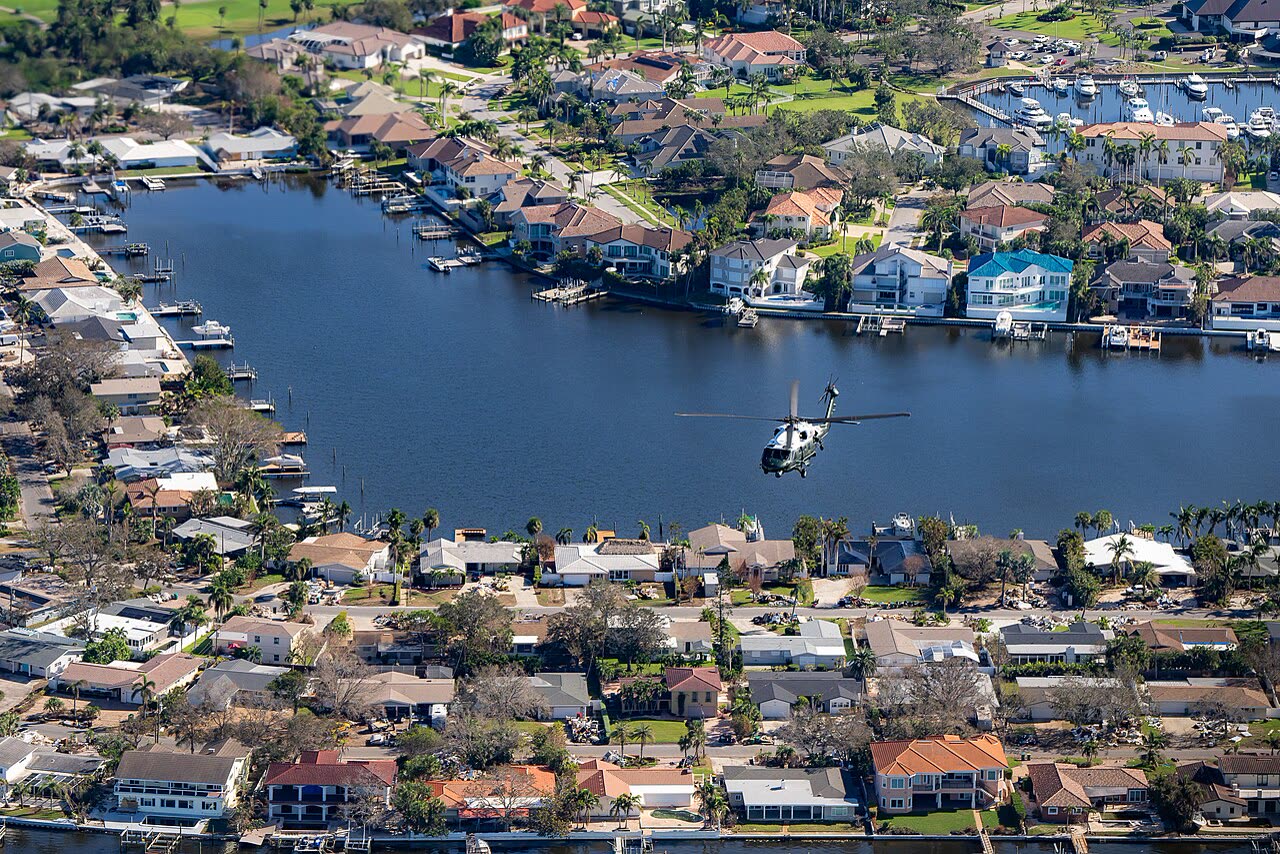
AERIAL The White House
Aerial view of St. Petersburg-area canal neighborhoods during the October 13 presidential damage survey — debris piles line the streets

The storm

Milton formed in the southwestern Gulf on October 5, 2024, and produced one of the most extreme rapid-intensification episodes ever observed in the Atlantic basin: by October 7 it was a Category 5 with 180 mph winds and a central pressure of 897 mb — among the lowest pressures on record in the basin.

It was aimed at Tampa Bay, 13 days after Helene's surge had already flooded the region's coastline. Wind shear weakened Milton on approach, and it made landfall near Siesta Key, south of Sarasota, on October 9, 2024, as a Category 3 with 120 mph winds.

The southward wobble spared Tampa Bay the worst surge — winds there actually blew water out of the bay — and sent the onshore surge into Sarasota, Manatee, and Charlotte counties instead. Milton crossed the peninsula overnight, dropping more than a foot of rain on the St. Petersburg area and spawning a destructive tornado outbreak across South Florida, including deadly tornadoes in St. Lucie County on the east coast.

Total: roughly $34 billion in damage and 42 deaths.

NHC forecast cone, Advisory 19 — 5 PM EDT October 9, hours before Siesta Key landfall
NHC forecast cone, Advisory 19 — 5 PM EDT October 9, hours before Siesta Key landfall NOAA / NHC

The damage

Milton's damage came in four distinct modes, often to the same counties.

Wind: roof damage across Sarasota, Manatee, Hillsborough, and Pinellas counties, including the shredded roof of Tropicana Field in St. Petersburg. Surge: coastal flooding from Siesta Key south through Venice and Manasota Key. Rain: urban freshwater flooding far from the coast — the Lake Bonny neighborhoods of Lakeland flooded despite sitting outside FEMA-designated flood risk zones, and most affected homeowners there carried no flood insurance. Tornadoes: the east-coast outbreak destroyed homes in counties that saw little of the hurricane itself.

The compounding factor was Helene. Barrier-island neighborhoods in Pinellas and Sarasota counties still had Helene's flood debris piled at the curb when Milton's wind arrived. Thousands of properties entered Milton with existing, unrepaired, and in many cases undocumented Helene damage.
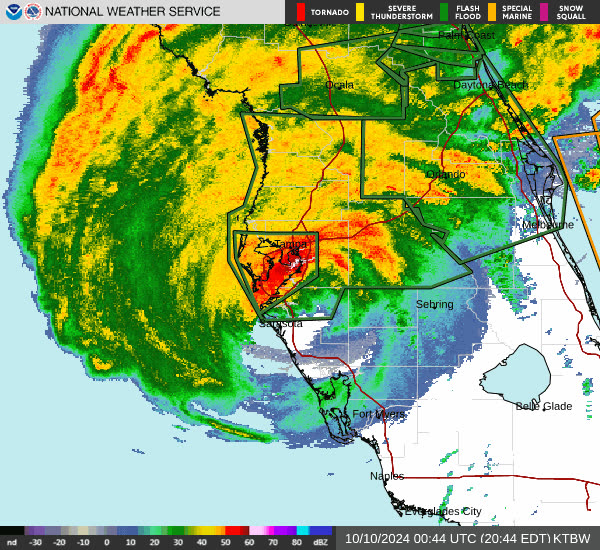
NWS Tampa Bay radar loop of Milton's Category 3 landfall near Siesta Key, night of October 9, 2024
NWS Tampa Bay radar loop of Milton's Category 3 landfall near Siesta Key, night of October 9, 2024 NOAA / NWS

The insurance aftermath

Milton generated the larger claim volume of the 2024 pair: 202,989 residential claims in FLOIR's November 2024 data, against Helene's 57,415. Of those Milton claims, 27,834 had already been closed without payment. Across both storms, 42% of the 329,000+ residential claims were closed without payment; FLOIR cited below-deductible losses and uncovered flood damage as the leading reasons. Combined insured losses for the two storms passed $4.1 billion within weeks and kept climbing.

The defining dispute was allocation. For a home that took Helene surge on September 26 and Milton wind on October 9, three questions controlled the payout: which storm caused which damage, which policy (homeowners vs. flood) responds to each, and how many hurricane deductibles apply. Florida's percentage hurricane deductible applies per season in some policy forms and per storm in others — a distinction many policyholders learned for the first time. Flood carriers pointed at wind; wind carriers pointed at Helene's water. Properties with no flood policy saw carriers attribute damage to surge, echoing the anti-concurrent-causation fights from Katrina.

Lakeland's Lake Bonny flooding became the season's example of the inland flood gap: rain-driven flooding in a non-mapped zone, excluded from homeowners policies, and largely uninsured because lenders never required flood coverage there.

FLOIR's emergency orders (issued for Helene, amended October 16, 2024 to cover Milton) froze cancellations and nonrenewals and extended claim-filing windows. Milton was also the first full test of Florida's post-2022 reform regime (SB 2-A) at catastrophe scale: shorter claim deadlines, no one-way attorney fees, and mandatory pre-suit notice — meaning disputed claims moved through appraisal and pre-suit processes rather than the litigation wave that followed Michael and Irma.
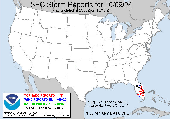
SPC storm reports for October 9, 2024 — the deadly pre-landfall tornado outbreak across the peninsula
SPC storm reports for October 9, 2024 — the deadly pre-landfall tornado outbreak across the peninsula NOAA / SPC

What policyholders learned

  • Two storms meant two files. Policyholders who filed separate, clearly dated claims for Helene and Milton damage — rather than one merged claim — kept allocation disputes from collapsing into a single denial.
  • The between-storms photo record was decisive. Documentation of property condition after Helene but before Milton (photos, adjuster reports, contractor estimates dated in the 13-day gap) was the single strongest evidence in wind-vs-flood and storm-allocation disputes.
  • "Flood, not wind" denials were contested with sequence evidence. Wind arrives before surge; policyholders used weather data, video, and engineering reports to establish wind-created openings and interior wind-driven rain damage independent of later flooding.
  • Non-mapped zones flood. Lake Bonny homeowners outside FEMA flood zones had no flood coverage and no homeowners coverage for rising water. Zone designation predicts lender requirements, not water.
  • Deductible math needed checking. Whether the hurricane deductible applied once per season or once per storm changed recoveries by thousands of dollars; policyholders who read the deductible clause caught carrier misapplication.
  • Post-reform deadlines were short. Under Florida's post-2022 rules, notice and supplement windows are far tighter than in the Michael era; late documentation forfeited otherwise valid claims.

Independent informational resource — not legal advice. Damage figures are nominal (not inflation-adjusted) unless noted. Insurance-law summaries are drafted for education; consult an attorney about your specific claim.

AT LANDFALL · HURRICANE MILTON · 2024
180 mph
SUSTAINED WINDS
HURRICANELAW.PRO FIELD FOOTAGE
03 THE FULL RECORD

Every official record of Milton

Reports, imagery archives, flood data, and claims records — straight from the agencies.

OUR LAW FIRM PARTNER · HALVERSEN LAW
Milton claim denied?
CALL FL941-390-3233CALL SC843-542-0454FREE CLAIM REVIEW
RELATED GUIDES
HurricaneLaw.Pro HURRICANELAW.PRO

The independent policyholder resource for Florida & South Carolina — storm archive, coverage law, denials, bad faith, and the complete claims playbook. 51 storms · 46 carriers · 97 public-adjuster firms · 37 city guides.

▸ SEE THE FULL SITE MAP — EVERY PAGE →
STORM ALERTS SOURCED FROM NOAA / NHC
SOUTH CAROLINA
496 Bramson Court, Suite 100
Mount Pleasant, SC 29464
CALL OR TEXT
FLORIDA
Tampa, FL
CALL OR TEXT
CLAIMS 9
DENIALS 8
BAD FAITH 7
COVERAGE 12
COMMERCIAL 8
ROOFS 8
TREES 5
DIRECTORIES
STORMS 51
WEATHER
NEWS & SITE 19
STORM ARCHIVE, CITIES & NEWS
Most recent below. Every storm dossier, city resource, and article is on its hub (linked at each heading) or the grouped site map →. All 46 carriers and 97 public-adjuster firms are in the Directories column above.
STORM ARCHIVE · 51 →
Hurricane Debby 2024Hurricane Helene 2024Hurricane Milton 2024Hurricane Idalia 2023Hurricane Ian 2022Hurricane Nicole 2022Hurricane Ida 2021Hurricane Laura 2020 View all 51 →
FLORIDA CITY RESOURCES · 29 →
Boca RatonBradentonCape CoralClearwaterDaytona BeachDestinFort LauderdaleFort Myers View all 29 →
SOUTH CAROLINA CITY RESOURCES · 8 →
BeaufortCharlestonColumbiaFlorenceGreenvilleHilton Head IslandMount PleasantMyrtle Beach
NEWS & UPDATES · 19 →

HurricaneLaw.Pro is an independent informational resource, not a law firm. Coverage summaries, policy-language quotations, dollar figures, deadlines, and chart examples throughout this site are general information based on typical or standard policy forms and are illustrative only — they are not a quote, a guarantee of coverage, or a promise of any outcome. Every insurance policy is different: your own policy, endorsements, and state law control, so read your policy and confirm current statutes. Weather imagery courtesy of NOAA, the National Hurricane Center, and the National Weather Service. Legal services are provided by our law firm partner, Halversen Law. Nothing on this site is legal advice; consult an attorney about your specific claim.

PrivacyTermsDisclaimerAboutContact
© 2026 HURRICANELAW.PRO — ALL RIGHTS RESERVED 27.9°N 82.5°W · ATLANTIC BASIN MONITOR
OUR LAW FIRM PARTNER
Halversen Law LICENSED · FLORIDA & SOUTH CAROLINA

All legal matters on this site are referred to and handled by our law firm partner, Halversen Law, a licensed law firm in Florida and South Carolina. HurricaneLaw.Pro is an informational resource and is not itself a law firm.

FREE CASE REVIEW