
PROPERTY-INSURANCE CLAIM HELP · FL & SC FL CITIESSC CITIESGUIDESTATESNEWSSITE MAPABOUT
HurricaneLaw.Pro HURRICANELAW.PRO
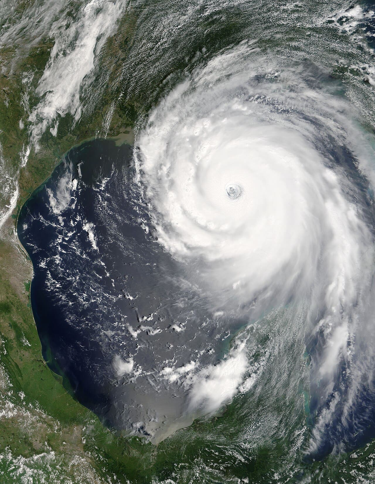
Katrina at Category 5 peak in the Gulf — 175 mph, 902 mb — August 28, 2005
STORM ARCHIVE / 2005
CAT 3 AT LANDFALL PEAK CAT 5 FL · 2005 · 175 mph

Hurricane Katrina

Landfall: Buras, LA · 2005-08-29. Largest NFIP payout in history ($16.3B) — and the wind-vs-water litigation that still defines hurricane claim denials

NASA (MODIS)
AT LANDFALL
CAT 3
PEAK INTENSITY
CAT 5 · 175 mph
PRESSURE
920 mb
STORM SURGE
24–28 ft
DAMAGE
$125B
DEATHS
1,392
01 THE PATH

Where it hit, start to finish

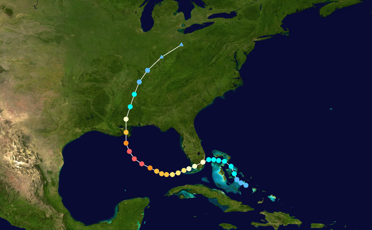
TRACK · HURRICANE KATRINANOAA / NHC best-track data
Best track of Hurricane Katrina, August 23-31, 2005 — the Florida Category 1 landfall, Gulf Category 5 peak, and Buras landfall
Hallandale Beach / Aventura, FL
CAT 1 LANDFALL · 80 MPH · AUG 25

Katrina's forgotten first strike: 14 Florida deaths and roughly $630 million in damage across Miami-Dade and Broward counties.

Central Gulf of Mexico
CAT 5 PEAK · 175 MPH · 902 MB · AUG 28

Explosive intensification over the Gulf loop current built an exceptionally large wind field — and piled up an ocean of surge that did not subside when the winds weakened.

Buras, LA
CAT 3 LANDFALL · 125 MPH · AUG 29

Second landfall at 920 mb on the morning of August 29; a third landfall followed hours later at the Louisiana-Mississippi border.

New Orleans, LA
LEVEE FAILURES · 80% FLOODED

Surge-driven levee and floodwall failures — including the 17th Street Canal — flooded about 80 percent of the city for weeks. Most of the storm's 1,392 deaths came here.

Pass Christian / Waveland / Bay St. Louis, MS
24-28 FT SURGE — U.S. RECORD

The highest storm surge ever recorded in the U.S. scraped the coast clean for blocks inland, leaving the slab cases that defined the wind-vs-water claims war.

Biloxi / Gulfport, MS
CASINO BARGES ASHORE

Surge carried floating casinos across US 90 and pushed 6-12 miles inland along bays and rivers on the Mississippi coast.

Tennessee Valley
INLAND DECAY · AUG 30

Hurricane-force gusts reached well into Mississippi; Katrina weakened to a tropical storm over the Tennessee Valley and merged with a frontal system on August 31.

02 THE RECORD IN IMAGES
ALL IMAGERY U.S. GOV / PUBLIC DOMAIN
SATELLITE NASA (MODIS/Terra)
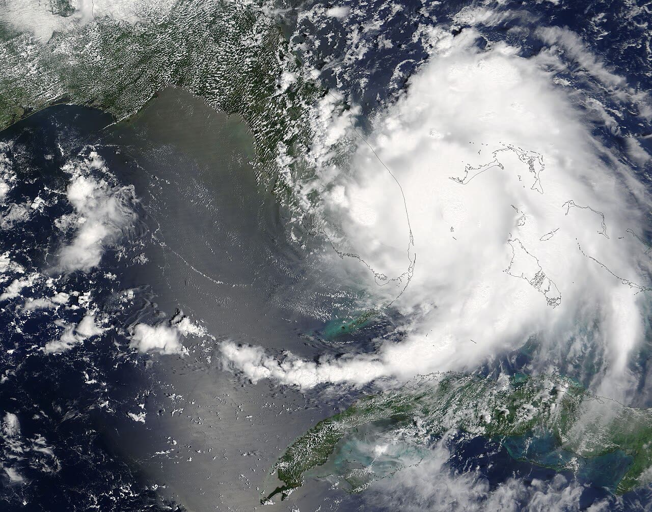
Katrina as a new Category 1 approaching southeast Florida, August 25, 2005 — the landfall Florida forgets
CONE NOAA / NHC
NHC advisory 15 — the first forecast cone to put Katrina's center over the New Orleans metro area
RADAR NOAA / NWS New Orleans
NWS New Orleans radar loop of Katrina's Louisiana landfall, August 29, 2005
AERIAL NOAA / NGS
17th Street Canal floodwall breach, August 31 — levee failures flooded about 80 percent of New Orleans
FLOOD NOAA
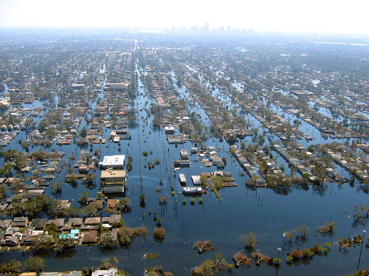
Flooded New Orleans from a NOAA helicopter — neighborhoods stood under water for weeks
FLOOD FEMA
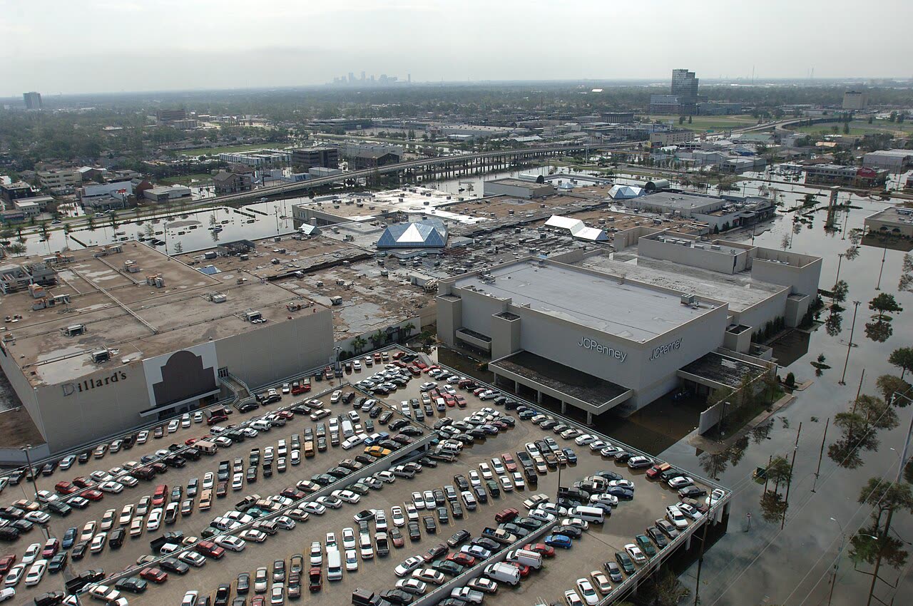
Flooded Metairie near Lakeside Mall, the New Orleans skyline in the distance
DAMAGE FEMA
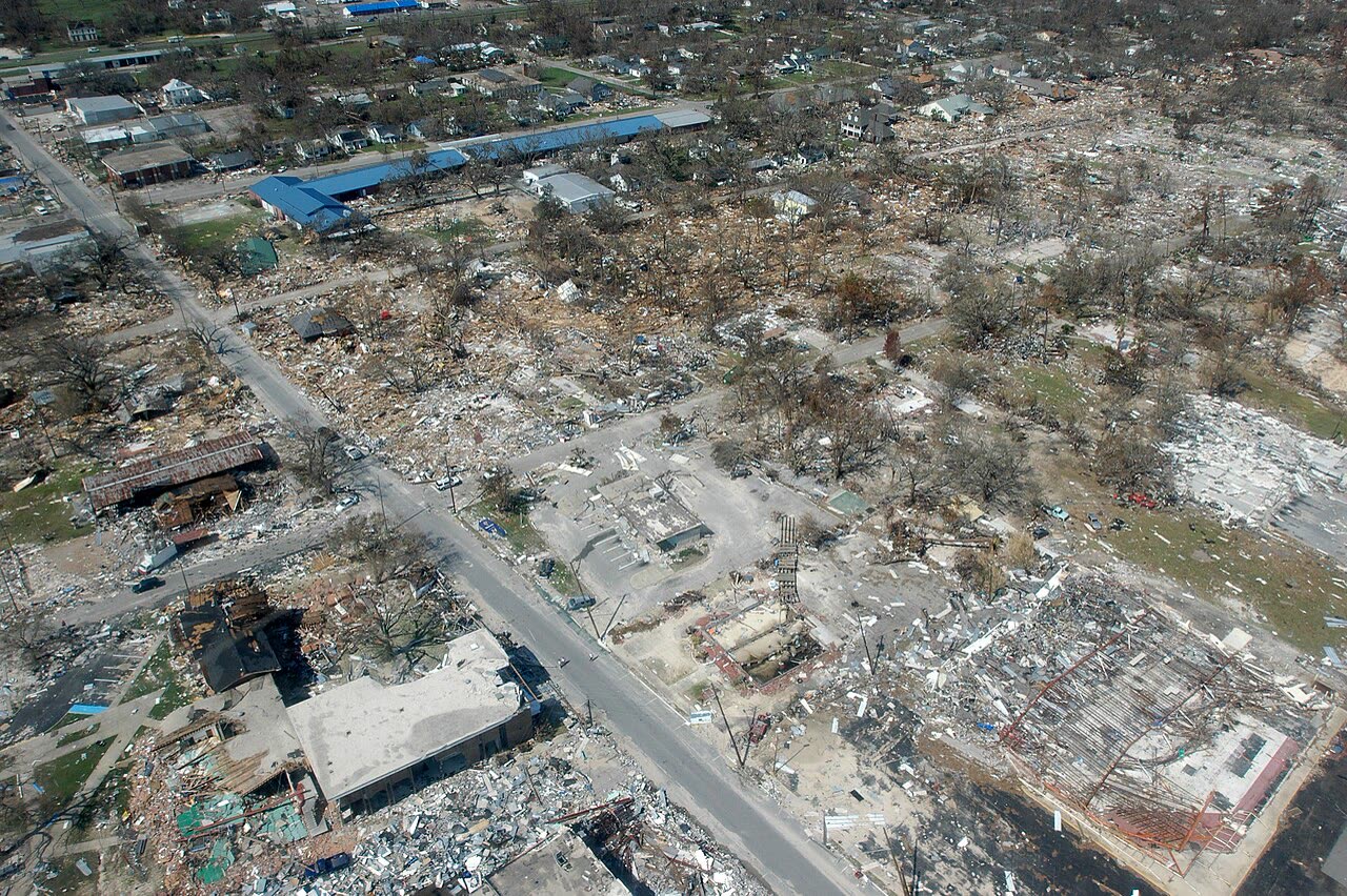
Destroyed businesses in Long Beach, Mississippi — between Pass Christian and Gulfport, where surge ran 24-28 ft
AERIAL U.S. Navy
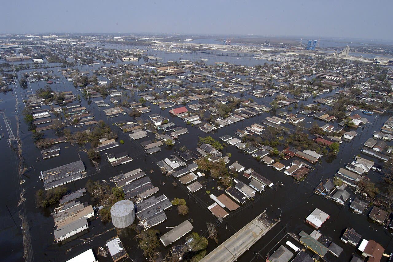
U.S. Navy aerial of flooded New Orleans neighborhoods, September 2, 2005 — four days after landfall

The storm

Katrina's first landfall is the one Florida forgets. On August 25, 2005, it came ashore between Hallandale Beach and Aventura as a Category 1 with 80 mph winds, crossed the peninsula, killed 14 people in Florida, and caused roughly $630 million in Florida damage — a real hurricane strike that was reduced to a footnote four days later.

Over the Gulf's warm loop current, Katrina exploded. By August 28 it was a Category 5 with 175 mph winds and a 902 mb central pressure, one of the strongest Atlantic hurricanes on record, with a wind field of exceptional size.

It weakened before the coast but the ocean it had piled up did not. Katrina made its second landfall near Buras, Louisiana, on the morning of August 29 as a Category 3 with 125 mph winds and a 920 mb pressure, then a third at the Louisiana–Mississippi border. Storm surge reached 24–28 feet along the Mississippi coast — the highest ever recorded in the U.S. In New Orleans, surge-driven levee and floodwall failures flooded about 80% of the city.

The National Hurricane Center's current accounting: 1,392 deaths and $125 billion in damage, the costliest U.S. hurricane on record at the time.
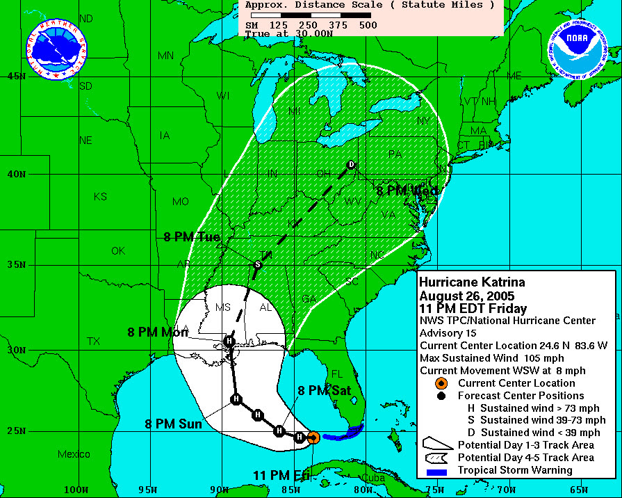
NHC advisory 15 — the first forecast cone to put Katrina's center over the New Orleans metro area
NHC advisory 15 — the first forecast cone to put Katrina's center over the New Orleans metro area NOAA / NHC

The damage

The Mississippi coast — Waveland, Bay St. Louis, Pass Christian, Gulfport, Biloxi — was effectively scraped clean for blocks inland. The signature Katrina damage scene was a concrete slab: house gone, no roof to inspect, no walls to read for wind-versus-water evidence. That absence of physical evidence became the central problem of the claims war that followed.

New Orleans flooded slowly rather than violently — levee failures put neighborhoods under water for weeks, destroying contents, drywall, and structures through prolonged inundation. Wind damage extended across Louisiana, Mississippi, and Alabama; surge damage reached Mobile Bay.

In Florida, the earlier Category 1 landfall left wind and flood damage across Miami-Dade and Broward counties — claims that were processed while the national attention, and the industry's adjusting capacity, moved to the Gulf.
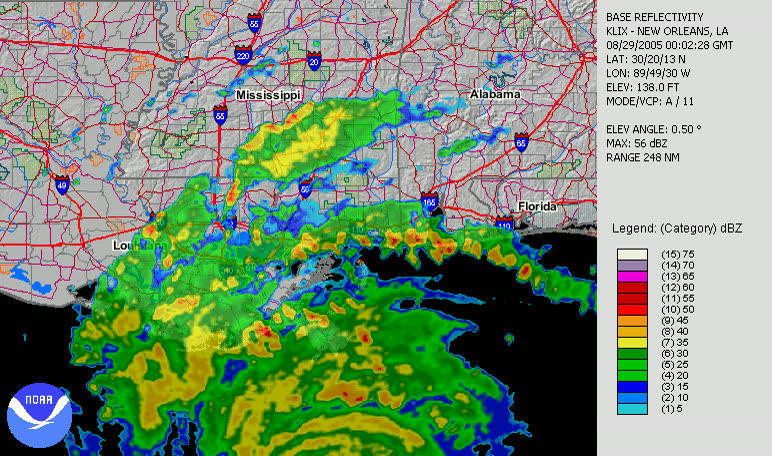
NWS New Orleans radar loop of Katrina's Louisiana landfall, August 29, 2005
NWS New Orleans radar loop of Katrina's Louisiana landfall, August 29, 2005 NOAA / NWS New Orleans

The insurance aftermath

Katrina generated about 1.7 million property claims across six states and roughly $41 billion in insured losses (2005 dollars) — at the time the largest insured loss event in U.S. history. The National Flood Insurance Program paid a record $16.3 billion, its largest payout ever, and Congress had to raise NFIP's borrowing authority from $1.5 billion to $20.8 billion to cover it. The NFIP has carried debt ever since.

The defining fight was wind versus water. Homeowners policies covered wind but excluded flood — and defined flood to include storm surge. On the Mississippi coast, where houses were reduced to slabs, carriers attributed the loss to excluded surge; policyholders argued wind destroyed their homes before the water arrived. With no structure left to examine, the burden of proof decided cases.

Two rulings still frame every hurricane denial today. In Leonard v. Nationwide (5th Cir. 2007), the court held that the flood exclusion encompasses wind-driven storm surge, and upheld anti-concurrent-causation (ACC) clauses — language providing that when an excluded peril (flood) and a covered peril (wind) combine to cause damage, the exclusion controls. In Corban v. USAA (Miss. 2009), the Mississippi Supreme Court pushed back: the insurer bears the burden of proving that excluded water, rather than covered wind, caused the loss, and the ACC clause applies only where wind and water act contemporaneously and in conjunction — wind damage that occurred before the surge arrived remains covered.

The litigation ran for years: mass actions, the Mississippi Attorney General's suits against carriers, State Farm's mass re-evaluation of Mississippi claims, and allegations that carriers steered damage attribution toward the federally funded NFIP (which paid full limits with no litigation risk to the carrier) and away from their own wind policies. Congress investigated; the "wind-water" conflict of interest — the same company adjusting both the wind policy and the NFIP flood policy on one house — became a permanent policyholder-side argument.

Every storm on this site inherits Katrina's legal architecture. The surge-vs-flood denials after Helene and the allocation fights after Milton run on ACC clauses and burden-of-proof rules written into law by Katrina litigation.
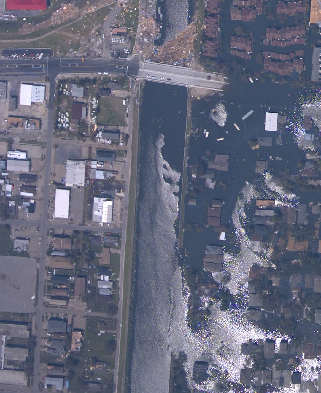
17th Street Canal floodwall breach, August 31 — levee failures flooded about 80 percent of New Orleans
17th Street Canal floodwall breach, August 31 — levee failures flooded about 80 percent of New Orleans NOAA / NGS

What policyholders learned

  • The flood exclusion includes storm surge. Leonard settled it: "flood" in a homeowners policy is not just rising rivers. Coastal owners without NFIP or private flood coverage bear surge losses themselves.
  • Burden of proof can win a slab case. Under Corban-line reasoning, policyholders argued the insurer must prove excluded water caused the loss; where evidence was destroyed, carriers could not simply presume surge.
  • Sequence evidence was everything. Policyholders who prevailed used timing: recorded wind speeds before surge arrival, neighbor testimony, debris patterns, and engineering analysis showing wind failure preceded inundation.
  • The dual-adjuster conflict was worth naming. Where one carrier handled both wind and NFIP flood policies, policyholders scrutinized whether damage was steered to the flood side, and demanded the wind file's engineering reports.
  • ACC language varies by policy. Post-Katrina, courts enforced ACC clauses as written — and read ambiguities against the insurer. Policyholders who obtained and read the actual exclusion language, rather than accepting a denial letter's summary, found policies without ACC wording or with narrower exclusions.
  • Contents and ALE documentation paid off. Prolonged-flooding losses in New Orleans showed the value of pre-loss home inventories and receipts for additional living expenses — categories carriers underpaid when records were thin.

Independent informational resource — not legal advice. Damage figures are nominal (not inflation-adjusted) unless noted. Insurance-law summaries are drafted for education; consult an attorney about your specific claim.

AT LANDFALL · HURRICANE KATRINA · 2005
24–28 ft
OF STORM SURGE · MS COAST
HURRICANELAW.PRO FIELD FOOTAGE
03 THE FULL RECORD

Every official record of Katrina

Reports, imagery archives, flood data, and claims records — straight from the agencies.

OUR LAW FIRM PARTNER · HALVERSEN LAW
Katrina claim denied?
CALL FL941-390-3233CALL SC843-542-0454FREE CLAIM REVIEW
RELATED GUIDES
HurricaneLaw.Pro HURRICANELAW.PRO

The independent policyholder resource for Florida & South Carolina — storm archive, coverage law, denials, bad faith, and the complete claims playbook. 51 storms · 46 carriers · 97 public-adjuster firms · 37 city guides.

▸ SEE THE FULL SITE MAP — EVERY PAGE →
STORM ALERTS SOURCED FROM NOAA / NHC
SOUTH CAROLINA
496 Bramson Court, Suite 100
Mount Pleasant, SC 29464
CALL OR TEXT
FLORIDA
Tampa, FL
CALL OR TEXT
CLAIMS 9
DENIALS 8
BAD FAITH 7
COVERAGE 12
COMMERCIAL 8
ROOFS 8
TREES 5
DIRECTORIES
STORMS 51
WEATHER
NEWS & SITE 19
STORM ARCHIVE, CITIES & NEWS
Most recent below. Every storm dossier, city resource, and article is on its hub (linked at each heading) or the grouped site map →. All 46 carriers and 97 public-adjuster firms are in the Directories column above.
STORM ARCHIVE · 51 →
Hurricane Debby 2024Hurricane Helene 2024Hurricane Milton 2024Hurricane Idalia 2023Hurricane Ian 2022Hurricane Nicole 2022Hurricane Ida 2021Hurricane Laura 2020 View all 51 →
FLORIDA CITY RESOURCES · 29 →
Boca RatonBradentonCape CoralClearwaterDaytona BeachDestinFort LauderdaleFort Myers View all 29 →
SOUTH CAROLINA CITY RESOURCES · 8 →
BeaufortCharlestonColumbiaFlorenceGreenvilleHilton Head IslandMount PleasantMyrtle Beach
NEWS & UPDATES · 19 →

HurricaneLaw.Pro is an independent informational resource, not a law firm. Coverage summaries, policy-language quotations, dollar figures, deadlines, and chart examples throughout this site are general information based on typical or standard policy forms and are illustrative only — they are not a quote, a guarantee of coverage, or a promise of any outcome. Every insurance policy is different: your own policy, endorsements, and state law control, so read your policy and confirm current statutes. Weather imagery courtesy of NOAA, the National Hurricane Center, and the National Weather Service. Legal services are provided by our law firm partner, Halversen Law. Nothing on this site is legal advice; consult an attorney about your specific claim.

PrivacyTermsDisclaimerAboutContact
© 2026 HURRICANELAW.PRO — ALL RIGHTS RESERVED 27.9°N 82.5°W · ATLANTIC BASIN MONITOR
OUR LAW FIRM PARTNER
Halversen Law LICENSED · FLORIDA & SOUTH CAROLINA

All legal matters on this site are referred to and handled by our law firm partner, Halversen Law, a licensed law firm in Florida and South Carolina. HurricaneLaw.Pro is an informational resource and is not itself a law firm.

FREE CASE REVIEW