PROPERTY-INSURANCE CLAIM HELP · FL & SC FL CITIESSC CITIESGUIDESTATESNEWSSITE MAPABOUT
HurricaneLaw.Pro HURRICANELAW.PRO
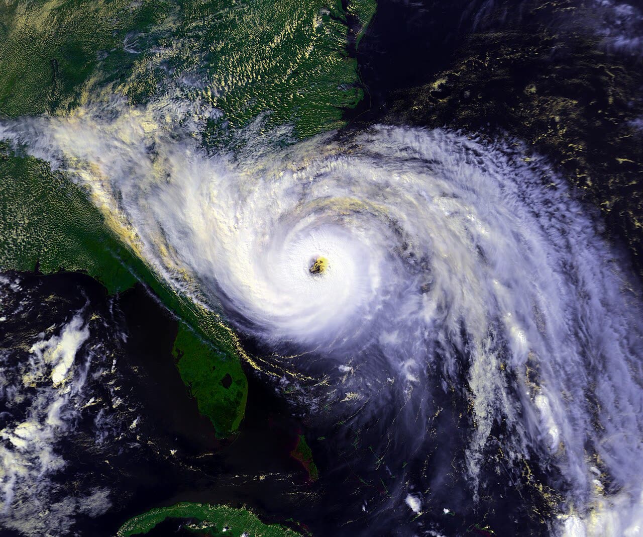
Hugo at Category 4 hours before South Carolina landfall, September 21, 1989 (NOAA-11 satellite)
STORM ARCHIVE / 1989 LANDFALL 32.8°N 79.8°W
CAT 4 AT LANDFALL PEAK CAT 5 SC · 1989 · 160 mph

Hurricane Hugo

Landfall: Sullivan's Island / Charleston, SC · 1989-09-22. The first US catastrophe to top $4 billion in insured claims — it exposed how unprepared insurers and coastal South Carolina were, and pushed the SC wind pool into its modern role.

NOAA / NESDIS
AT LANDFALL
CAT 4
PEAK INTENSITY
CAT 5 · 160 mph
PRESSURE
934 mb
STORM SURGE
19.8 ft
DAMAGE
$7B US
DEATHS
49 direct (US/Caribbean)
01 THE PATH

Where it hit, start to finish

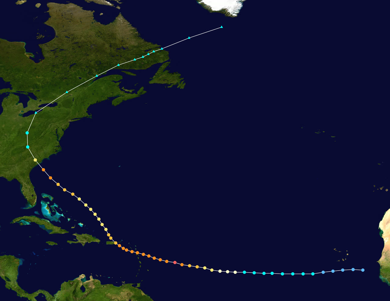
TRACK · HURRICANE HUGONOAA / NHC best-track data
Best track of Hurricane Hugo, September 9-25, 1989 — Caribbean crossings and the Sullivan's Island landfall
Guadeloupe
CAT 4 STRIKE · SEPT 17

Hugo's eye crossed Guadeloupe with winds near 140 mph — 11 deaths and thousands left homeless.

St. Croix, USVI
DIRECT HIT · CAT 4 · SEPT 17-18

The eye passed directly over St. Croix; roughly 90 percent of buildings were damaged or destroyed and the island lost power and water for weeks.

Eastern Puerto Rico
125 MPH · SEPT 18

Hugo raked Vieques, Culebra, and eastern Puerto Rico — about $1 billion in damage and tens of thousands homeless.

Sullivan's Island / Charleston, SC
CAT 4 LANDFALL · 135-140 MPH · SEPT 22

Landfall near midnight at 934 mb after re-intensifying on final approach; 13 ft of surge on Sullivan's Island and 10.4 ft in downtown Charleston.

Bulls Bay / McClellanville, SC
19.8 FT SURGE — EAST COAST RECORD

The right-front quadrant drove 19.8 ft of surge into Bulls Bay; the shrimp fleet was carried into McClellanville and surge flooded the Lincoln High School shelter.

Sumter / Columbia, SC
HURRICANE WINDS 100+ MI INLAND

Shaw AFB in Sumter gusted to 109 mph; roughly 4.5 million acres of South Carolina timber went down and 80 percent of the state lost power.

Charlotte, NC
~100 MPH GUSTS · 175 MI INLAND

Hugo's 25+ mph forward speed carried hurricane-force gusts 200 miles inland — Charlotte saw gusts near 100 mph, massive tree loss, and outages lasting up to two weeks before Hugo raced on toward Canada.

02 THE RECORD IN IMAGES
ALL IMAGERY U.S. GOV / PUBLIC DOMAIN
SATELLITE NOAA
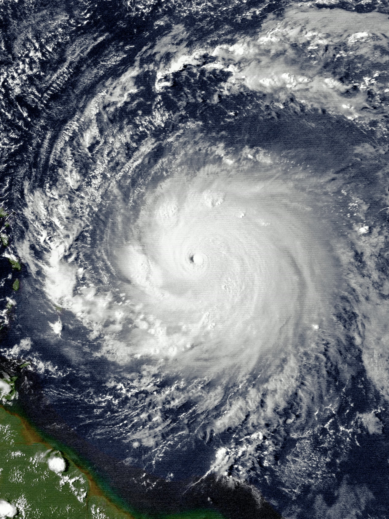
Hugo near Category 5 peak intensity east of the Leeward Islands, September 15, 1989
SATELLITE NOAA / NWS
Hugo making landfall near Charleston, September 22, 1989
DAMAGE NOAA / NWS
Devastation on Culebra Island, Puerto Rico, after Hugo's Category 4 Caribbean crossing
DAMAGE U.S. Army Corps of Engineers
Damage in Christiansted, St. Croix — roughly 90 percent of the island's buildings were damaged or destroyed
SURGE NOAA
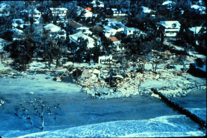
Beachfront property destroyed by Hugo's storm surge on the South Carolina coast
AERIAL U.S. DoD / National Archives
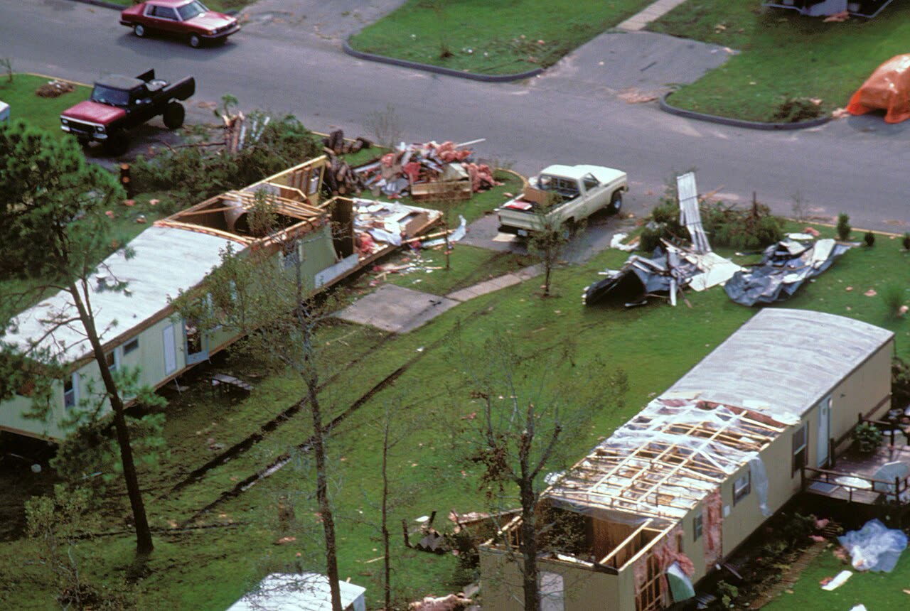
Aerial of a destroyed trailer park in the Charleston area
MAP NOAA / WPC
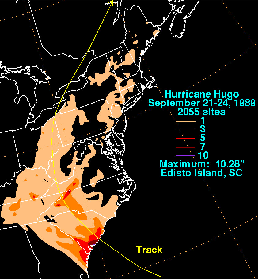
Rainfall totals along Hugo's track from the Carolinas into the Northeast

The storm

Hugo was a classic Cape Verde hurricane. It left Africa as a tropical wave on September 9, 1989, became a hurricane on the 13th, and peaked at Category 5 — about 160 mph — east of the Leeward Islands. It tore through Guadeloupe, St. Croix, and Puerto Rico as a Category 4, then turned northwest toward the Carolinas.

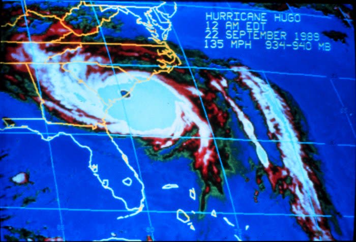
Instead of weakening over cooler shelf water, Hugo re-intensified on final approach. It crossed the South Carolina coast at Sullivan's Island, just north of Charleston, around midnight on September 21–22 as a Category 4: sustained winds estimated at 135–140 mph and central pressure of 934 mb (NWS Charleston).

Two things made Hugo's footprint unusual. First, the surge: the right-front quadrant drove water into the shallow bight north of Charleston, producing 19.8 ft at Bulls Bay — among the highest storm-surge values ever recorded on the U.S. East Coast — with 13 ft at Sullivan's Island and 10.4 ft in downtown Charleston. Second, the speed: Hugo accelerated inland at more than 25 mph, carrying hurricane-force wind gusts over 200 miles from the coast. Charlotte, North Carolina — 175 miles inland — recorded gusts near 100 mph.

Hugo making landfall near Charleston, September 22, 1989
Hugo making landfall near Charleston, September 22, 1989 NOAA / NWS

The damage

The barrier islands took the surge. Houses on Sullivan's Island, Isle of Palms, Folly Beach, and at Garden City were washed off foundations or removed entirely; the fishing fleet at McClellanville was carried into the town. In McClellanville, residents sheltering at Lincoln High School climbed onto tables as surge flooded the designated shelter.

Inland, wind did the work. Roof coverings failed across the Charleston area, and rain entering opened roofs soaked interiors — the same wind-plus-water damage chain that would repeat in Andrew three years later. About 79,000 homes were damaged in South Carolina (III). Eighty percent of the state lost power. Timber losses were enormous: roughly 4.5 million acres of trees down, and fallen trees accounted for a large share of structure damage far inland along the Hugo corridor through Sumter, Camden, and into North Carolina.

NWS Charleston attributes 49 direct deaths to Hugo overall, 26 of them in the U.S., Puerto Rico, and the U.S. Virgin Islands. South Carolina death counts vary by source and by direct/indirect definition — figures from 13 to 35 appear in official and press accounts. U.S. damage was approximately $7 billion nominal, the nation's costliest disaster to that date.
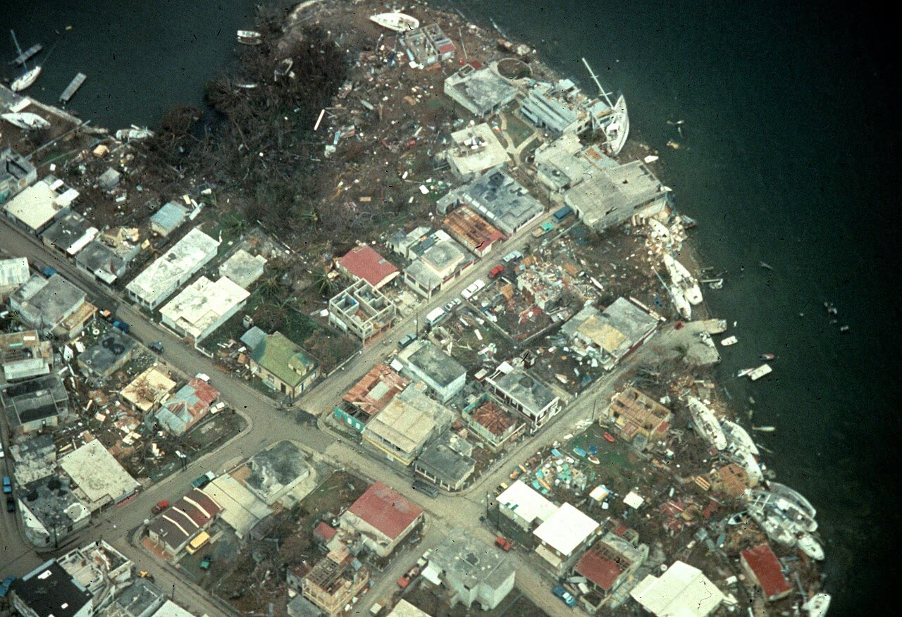
Devastation on Culebra Island, Puerto Rico, after Hugo's Category 4 Caribbean crossing
Devastation on Culebra Island, Puerto Rico, after Hugo's Category 4 Caribbean crossing NOAA / NWS

The insurance aftermath

Hugo was the insurance industry's wake-up call before the wake-up call. Insurers paid nearly $4.2 billion in claims (III) — the most expensive single event in the history of U.S. insurance at the time, and the first U.S. catastrophe to break the billion-dollar-plus scale that models of the era treated as remote. Three years later Andrew nearly quadrupled it; the two storms together launched the modern catastrophe-modeling and reinsurance-pricing era.

On the ground, the claims infrastructure was overwhelmed. Insurers airlifted adjusters into a region with no power, no phones, and blocked roads; claims backlogs stretched for months. Recurring disputes:

  • Wind vs. water. Surge-destroyed slab-only properties on the barrier islands produced the classic fight: homeowners' policies excluded flood (including storm surge), and NFIP flood policies — where they existed — carried lower limits. Many island owners carried no flood coverage at all. A National Academies post-storm study found roughly 15 percent of surveyed households had no insurance of any kind.
  • Wind-driven rain. Where roofs opened, carriers generally paid; where water entered around intact openings, coverage was contested — a denial pattern that has never left coastal claims.
  • Tree and debris losses. Millions of downed trees produced volume disputes over removal costs, fence and outbuilding damage, and what a policy actually pays for a tree that hits nothing.

Structurally, Hugo cemented the South Carolina Wind and Hail Underwriting Association — the coastal "wind pool" — as the market of last resort for wind coverage in the designated beach zone, as private carriers repriced and restricted coastal wind exposure. Coastal property owners increasingly ended up with split coverage: a standard homeowners policy excluding wind, a wind-pool policy for wind/hail, and a separate NFIP policy for flood — three policies, three deductibles, and built-in coverage-boundary disputes for every future storm.

Hugo's legal echo reached the U.S. Supreme Court. South Carolina's Beachfront Management Act (1988) barred rebuilding seaward of setback lines; after Hugo, lot owner David Lucas challenged the ban, and Lucas v. South Carolina Coastal Council, 505 U.S. 1003 (1992), became a landmark regulatory-takings decision — a reminder that post-storm rebuilding rules, not just insurance proceeds, determine what a coastal owner recovers.
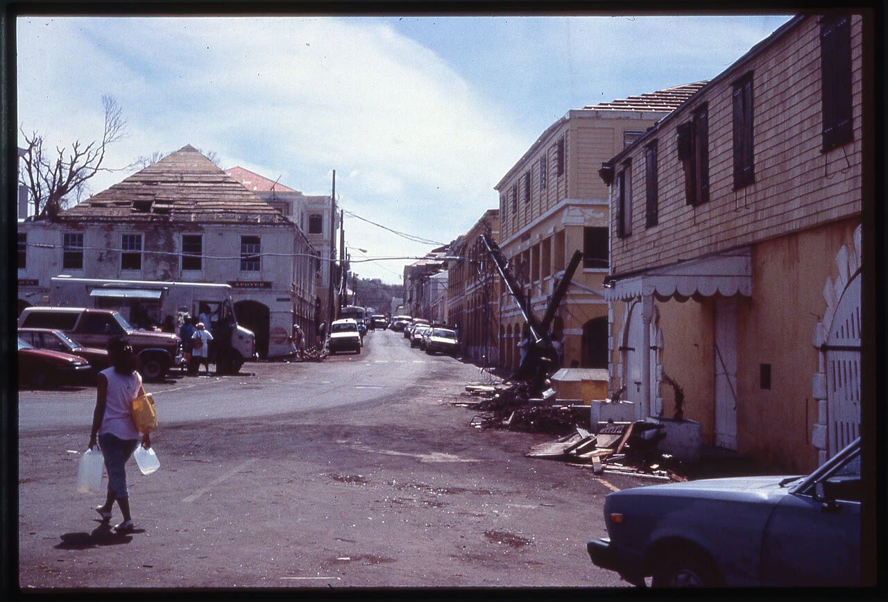
Damage in Christiansted, St. Croix — roughly 90 percent of the island's buildings were damaged or destroyed
Damage in Christiansted, St. Croix — roughly 90 percent of the island's buildings were damaged or destroyed U.S. Army Corps of Engineers

What policyholders learned

  • The flood exclusion decides barrier-island claims. Owners without NFIP coverage recovered little for surge-destroyed homes. The documented lesson: surge is "flood" under a homeowners policy, no matter that a hurricane caused it.
  • Proving wind-before-water won contested claims. Where owners could show wind breached the roof or walls before surge arrived — neighbor accounts, timing of wind vs. tide, debris patterns — carriers paid wind claims on properties that also flooded.
  • Roof-opening evidence beat "wind-driven rain" denials. Interior water claims succeeded when tied to a documented exterior breach. Photographs of the roof and envelope, taken before tarping and repairs, made that link.
  • Inland owners were surprised to be hurricane claimants. Hugo put hurricane-force gusts in Charlotte. Policyholders 200 miles from the coast learned their wind claims and (where applicable) special deductibles worked the same as coastal ones.
  • Adjuster scarcity rewarded documentation. With adjusters handling extreme volume, files with dated photos, itemized damage lists, and repair estimates settled first and fullest; undocumented claims sat.
  • Rebuilding rules are part of recovery. Setback and permitting law — litigated in Lucas — determined whether beachfront owners could rebuild at all. Insurance proceeds and rebuild entitlement are separate questions.

Independent informational resource — not legal advice. Damage figures are nominal (not inflation-adjusted) unless noted. Insurance-law summaries are drafted for education; consult an attorney about your specific claim.

AT LANDFALL · HURRICANE HUGO · 1989
19.8 ft
OF STORM SURGE · BULLS BAY
HURRICANELAW.PRO FIELD FOOTAGE
03 THE FULL RECORD

Every official record of Hugo

Reports, imagery archives, flood data, and claims records — straight from the agencies.

OUR LAW FIRM PARTNER · HALVERSEN LAW
Hugo claim denied?
CALL FL941-390-3233CALL SC843-542-0454FREE CLAIM REVIEW
RELATED GUIDES
HurricaneLaw.Pro HURRICANELAW.PRO

The independent policyholder resource for Florida & South Carolina — storm archive, coverage law, denials, bad faith, and the complete claims playbook. 51 storms · 46 carriers · 97 public-adjuster firms · 37 city guides.

▸ SEE THE FULL SITE MAP — EVERY PAGE →
STORM ALERTS SOURCED FROM NOAA / NHC
SOUTH CAROLINA
496 Bramson Court, Suite 100
Mount Pleasant, SC 29464
CALL OR TEXT
FLORIDA
Tampa, FL
CALL OR TEXT
CLAIMS 9
DENIALS 8
BAD FAITH 7
COVERAGE 12
COMMERCIAL 8
ROOFS 8
TREES 5
DIRECTORIES
STORMS 51
WEATHER
NEWS & SITE 19
STORM ARCHIVE, CITIES & NEWS
Most recent below. Every storm dossier, city resource, and article is on its hub (linked at each heading) or the grouped site map →. All 46 carriers and 97 public-adjuster firms are in the Directories column above.
STORM ARCHIVE · 51 →
Hurricane Debby 2024Hurricane Helene 2024Hurricane Milton 2024Hurricane Idalia 2023Hurricane Ian 2022Hurricane Nicole 2022Hurricane Ida 2021Hurricane Laura 2020 View all 51 →
FLORIDA CITY RESOURCES · 29 →
Boca RatonBradentonCape CoralClearwaterDaytona BeachDestinFort LauderdaleFort Myers View all 29 →
SOUTH CAROLINA CITY RESOURCES · 8 →
BeaufortCharlestonColumbiaFlorenceGreenvilleHilton Head IslandMount PleasantMyrtle Beach
NEWS & UPDATES · 19 →

HurricaneLaw.Pro is an independent informational resource, not a law firm. Coverage summaries, policy-language quotations, dollar figures, deadlines, and chart examples throughout this site are general information based on typical or standard policy forms and are illustrative only — they are not a quote, a guarantee of coverage, or a promise of any outcome. Every insurance policy is different: your own policy, endorsements, and state law control, so read your policy and confirm current statutes. Weather imagery courtesy of NOAA, the National Hurricane Center, and the National Weather Service. Legal services are provided by our law firm partner, Halversen Law. Nothing on this site is legal advice; consult an attorney about your specific claim.

PrivacyTermsDisclaimerAboutContact
© 2026 HURRICANELAW.PRO — ALL RIGHTS RESERVED 27.9°N 82.5°W · ATLANTIC BASIN MONITOR
OUR LAW FIRM PARTNER
Halversen Law LICENSED · FLORIDA & SOUTH CAROLINA

All legal matters on this site are referred to and handled by our law firm partner, Halversen Law, a licensed law firm in Florida and South Carolina. HurricaneLaw.Pro is an informational resource and is not itself a law firm.

FREE CASE REVIEW