PROPERTY-INSURANCE CLAIM HELP · FL & SC FL CITIESSC CITIESGUIDESTATESNEWSSITE MAPABOUT
HurricaneLaw.Pro HURRICANELAW.PRO
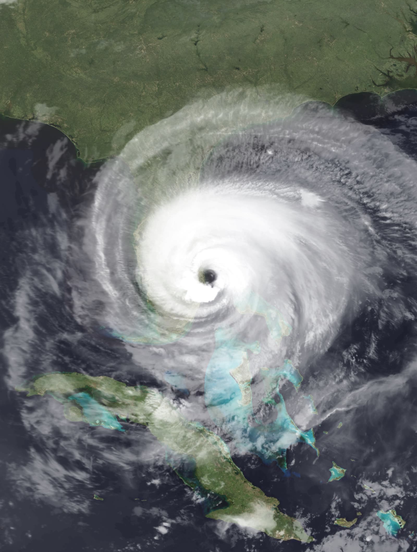
Jeanne's 50-nautical-mile-wide eye approaching the Florida east coast, 45 minutes before landfall, September 26, 2004
STORM ARCHIVE / 2004 LANDFALL 27.2°N 80.3°W
CAT 3 FL · 2004 · 120 mph

Hurricane Jeanne

Landfall: Hutchinson Island, FL (east of Stuart) — same island Frances struck 21 days earlier · 2004-09-26. Struck the same island as Frances three weeks later — adjusters split single wrecked roofs between two storms, two claims, two deductibles

NOAA
AT LANDFALL
CAT 3
PEAK WIND
120 mph
PRESSURE
950 mb
STORM SURGE
3.8 ft
DAMAGE
~$7.5B
DEATHS
5
01 THE PATH

Where it hit, start to finish

TRACK · HURRICANE JEANNENOAA / NHC (best-track data)
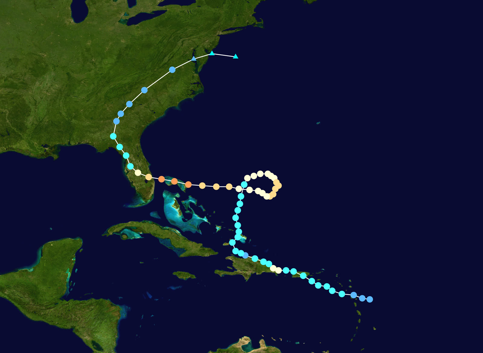
Best track of Hurricane Jeanne, September 13–28, 2004 — including the clockwise Atlantic loop
Haiti
CATASTROPHIC FLOODING — 3,000+ DEAD

As a tropical storm, Jeanne's rains triggered flooding and mudslides that killed more than 3,000 people, nearly 2,900 in Gonaïves alone — one of the deadliest Atlantic storms of the modern era.

Open Atlantic
THE LOOP

Written off as it drifted out to sea, Jeanne executed a large clockwise loop, crossed its own track September 23, and re-intensified to 100 kt while crossing Abaco and Grand Bahama.

Hutchinson Island, FL
CAT 3 LANDFALL — SAME SPOT AS FRANCES

Landfall at 0400 UTC September 26: 120 mph, 950 mb, with a 50-n-mi-wide eye crossing the southern end of Hutchinson Island near Stuart — essentially the same point Frances hit 21 days earlier. Surge ran up to 6 ft from Melbourne to Ft. Pierce.

Treasure Coast / Central FL
FOURTH STORM IN SIX WEEKS

Jeanne re-crossed Frances's damage footprint: tarped roofs failed, weakened structures went down, and up to 11.97 in of rain at Kenansville fell on saturated ground. Florida's fourth hurricane of 2004 made it the first state hit four times since Texas in 1886.

Georgia / Carolinas / Virginia
DISSIPATION

Jeanne weakened inland, spreading rain and tornadoes through the Southeast — including a fatal September 27 tornado in Fairfield County, SC. US damage: ~$7.5B nominal; 5 direct US deaths.

02 THE RECORD IN IMAGES
ALL IMAGERY U.S. GOV / PUBLIC DOMAIN
CONE NOAA / NHC
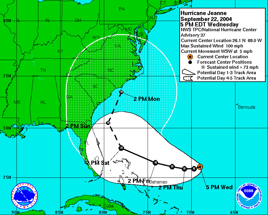
NHC five-day forecast from September 22, as Jeanne finished its loop and turned back toward Florida
SURGE FEMA / Mark Wolfe
Surge and erosion damage at Vero Beach two days after landfall — Jeanne finished what Frances started
MAP NOAA / WPC (David Roth)
US rainfall from Jeanne — up to 11.97 in at Kenansville, FL, on ground already saturated by three prior storms

The storm

Jeanne killed more than 3,000 people in Haiti as a mere tropical storm, its rains drowning the city of Gonaïves in mud. Then it appeared to leave — drifting into the open Atlantic, where forecasts initially carried it out to sea. Instead, Jeanne executed a large clockwise loop, crossed its own track on September 23, and came back west, strengthening to Category 3 as it crossed Abaco and Grand Bahama.

Landfall came at 0400 UTC on September 26, 2004: 120 mph and 950 mb, with the center of a 50-nautical-mile-wide eye crossing the southern end of Hutchinson Island just east of Stuart — for practical purposes the same landfall point as Frances, 21 days earlier. Surge reached 3.8 feet at Port Canaveral's Trident Pier, with up to 6 feet from Melbourne south to Ft. Pierce. Rainfall topped out at 11.97 inches at Kenansville on ground already saturated by three prior storms. Jeanne was Florida's fourth hurricane in six weeks — the first four-hurricane state season since Texas in 1886. Five direct US deaths; about $7.5 billion in US damage.
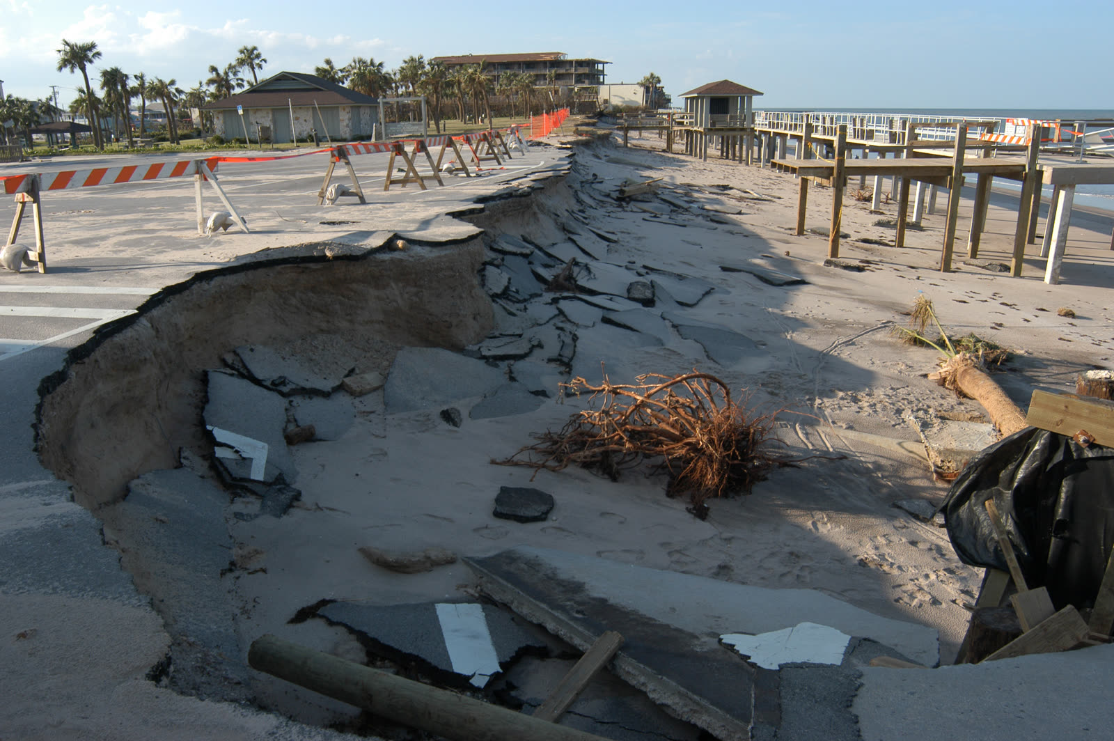
Surge and erosion damage at Vero Beach two days after landfall — Jeanne finished what Frances started
Surge and erosion damage at Vero Beach two days after landfall — Jeanne finished what Frances started FEMA / Mark Wolfe

The damage

Jeanne's footprint was Frances's footprint, hit harder. Roofs opened by Frances and covered in blue tarps were stripped again; structures weakened in early September failed outright in late September. Beach erosion at Vero Beach and along the Treasure Coast compounded — dunes and seawalls that had absorbed Frances had nothing left for Jeanne. Wind damage spread across the same Central Florida counties Charley and Frances had crossed, and tornadoes followed the storm into the Carolinas, killing one man in Fairfield County, South Carolina.
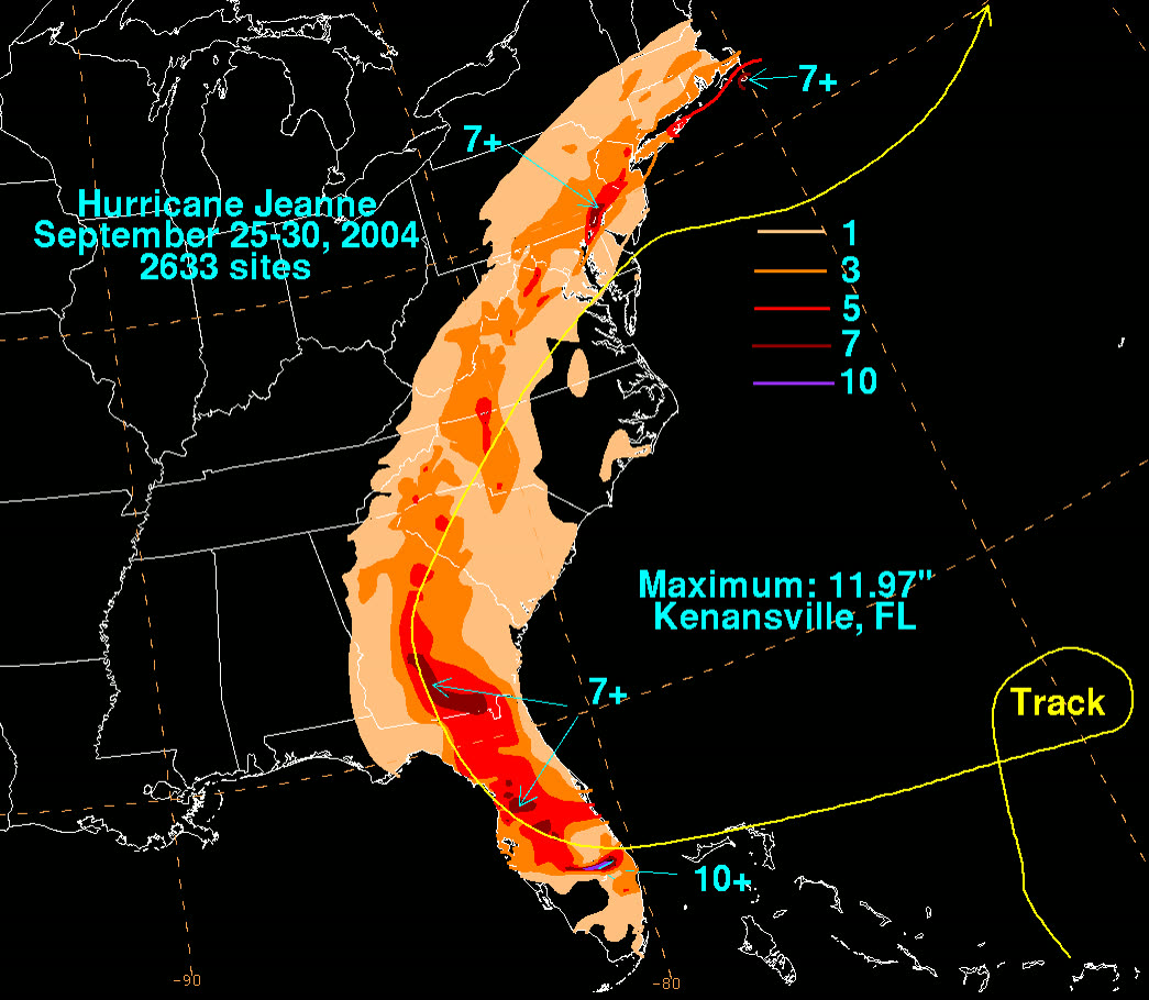
US rainfall from Jeanne — up to 11.97 in at Kenansville, FL, on ground already saturated by three prior storms
US rainfall from Jeanne — up to 11.97 in at Kenansville, FL, on ground already saturated by three prior storms NOAA / WPC (David Roth)

The insurance aftermath

Insured US losses were $3.44 billion — but Jeanne's real legacy was the allocation problem. Hundreds of thousands of properties had open, unresolved Frances claims when Jeanne hit. Every one of those files became a comparative-causation exercise: which storm broke the roof, which storm soaked the interior, how much erosion belonged to each event. The answer determined whose deductible applied and whether a carrier could attribute damage to an earlier, under-documented event.

The stacking was brutal. A Stuart-area home could owe hurricane deductibles for Frances and Jeanne — each 2 to 5 percent of dwelling coverage — before either claim paid. Jeanne pushed the 2004 multi-deductible problem past the political breaking point: the December 2004 special session created a state reimbursement program (chapter 2004-480) for second and subsequent 2004 deductibles, and the 2005 Legislature converted Florida to a single calendar-year hurricane deductible going forward. The full legislative arc is in the Frances dossier.

Jeanne also fed the season's cumulative market damage: roughly 2.2 million claims and $21 billion insured across the four storms, a Citizens Property Insurance deficit assessed against policyholders statewide, and carrier balance sheets weak enough that the 2005 season — Dennis, Katrina, Wilma — tipped several Florida insurers, including the Poe Financial Group companies, into insolvency and triggered the 2006–07 reform wave.

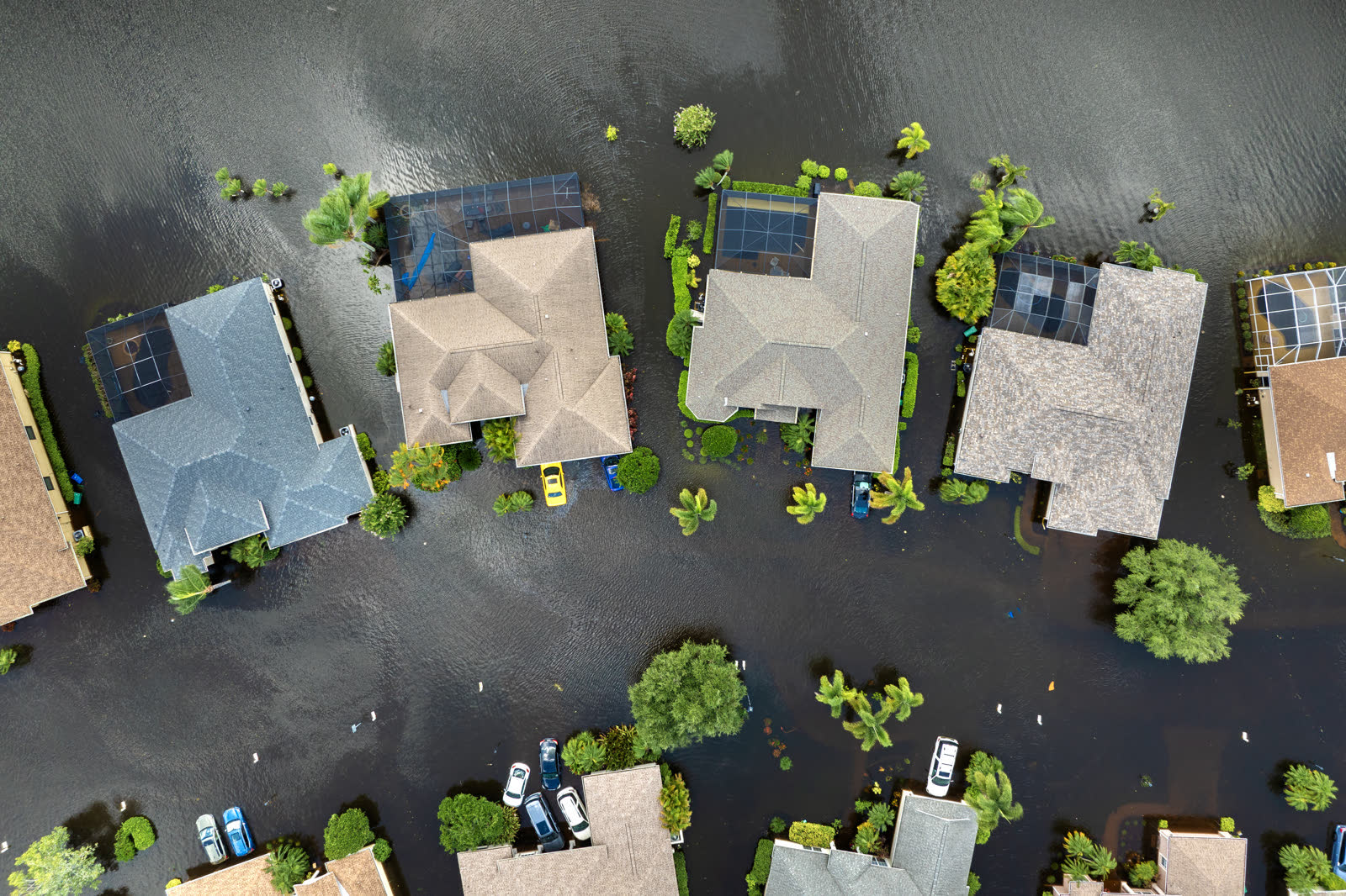
Tropical-storm flooding, Florida
Tropical-storm flooding, Florida HURRICANELAW.PRO FIELD FOOTAGE

What policyholders learned

  • Between-storm documentation decided claims. Owners with dated photos of Frances damage — and of temporary repairs — could prove what Jeanne added. Without them, carriers allocated damage to whichever file was cheaper to close.
  • Report every storm separately, fast. Waiting to file "one claim for the season" gave carriers grounds to dispute dates of loss; separate, prompt notices for Frances and Jeanne protected both claims.
  • Tarp failures were still covered. Damage through a properly tarped opening was generally compensable as storm damage; carriers that blamed "inadequate temporary repairs" typically retreated when owners produced receipts and photos of mitigation efforts.
  • Mitigation is a policy duty with a paper trail. The tarps, plywood, and water extraction after Frances weren't optional — and their costs were reimbursable. Owners who kept receipts recovered them.
  • Deductible reimbursement required applying. The 2004 program paid only policyholders who applied to DFS by March 1, 2005, with proof of multiple applied deductibles — a reminder that relief programs reward the documented.

Independent informational resource — not legal advice. Damage figures are nominal (not inflation-adjusted) unless noted. Insurance-law summaries are drafted for education; consult an attorney about your specific claim.

AT LANDFALL · HURRICANE JEANNE · 2004
3.8 ft; up to 6 ft Melbourne–Ft. Pierce
OF STORM SURGE · TRIDENT PIER, PORT CANAVERAL
HURRICANELAW.PRO FIELD FOOTAGE
03 THE FULL RECORD

Every official record of Jeanne

Reports, imagery archives, flood data, and claims records — straight from the agencies.

OUR LAW FIRM PARTNER · HALVERSEN LAW
Jeanne claim denied?
CALL FL941-390-3233CALL SC843-542-0454FREE CLAIM REVIEW
RELATED GUIDES
HurricaneLaw.Pro HURRICANELAW.PRO

The independent policyholder resource for Florida & South Carolina — storm archive, coverage law, denials, bad faith, and the complete claims playbook. 51 storms · 46 carriers · 97 public-adjuster firms · 37 city guides.

▸ SEE THE FULL SITE MAP — EVERY PAGE →
STORM ALERTS SOURCED FROM NOAA / NHC
SOUTH CAROLINA
496 Bramson Court, Suite 100
Mount Pleasant, SC 29464
CALL OR TEXT
FLORIDA
Tampa, FL
CALL OR TEXT
CLAIMS 9
DENIALS 8
BAD FAITH 7
COVERAGE 12
COMMERCIAL 8
ROOFS 8
TREES 5
DIRECTORIES
STORMS 51
WEATHER
NEWS & SITE 19
STORM ARCHIVE, CITIES & NEWS
Most recent below. Every storm dossier, city resource, and article is on its hub (linked at each heading) or the grouped site map →. All 46 carriers and 97 public-adjuster firms are in the Directories column above.
STORM ARCHIVE · 51 →
Hurricane Debby 2024Hurricane Helene 2024Hurricane Milton 2024Hurricane Idalia 2023Hurricane Ian 2022Hurricane Nicole 2022Hurricane Ida 2021Hurricane Laura 2020 View all 51 →
FLORIDA CITY RESOURCES · 29 →
Boca RatonBradentonCape CoralClearwaterDaytona BeachDestinFort LauderdaleFort Myers View all 29 →
SOUTH CAROLINA CITY RESOURCES · 8 →
BeaufortCharlestonColumbiaFlorenceGreenvilleHilton Head IslandMount PleasantMyrtle Beach
NEWS & UPDATES · 19 →

HurricaneLaw.Pro is an independent informational resource, not a law firm. Coverage summaries, policy-language quotations, dollar figures, deadlines, and chart examples throughout this site are general information based on typical or standard policy forms and are illustrative only — they are not a quote, a guarantee of coverage, or a promise of any outcome. Every insurance policy is different: your own policy, endorsements, and state law control, so read your policy and confirm current statutes. Weather imagery courtesy of NOAA, the National Hurricane Center, and the National Weather Service. Legal services are provided by our law firm partner, Halversen Law. Nothing on this site is legal advice; consult an attorney about your specific claim.

PrivacyTermsDisclaimerAboutContact
© 2026 HURRICANELAW.PRO — ALL RIGHTS RESERVED 27.9°N 82.5°W · ATLANTIC BASIN MONITOR
OUR LAW FIRM PARTNER
Halversen Law LICENSED · FLORIDA & SOUTH CAROLINA

All legal matters on this site are referred to and handled by our law firm partner, Halversen Law, a licensed law firm in Florida and South Carolina. HurricaneLaw.Pro is an informational resource and is not itself a law firm.

FREE CASE REVIEW