
PROPERTY-INSURANCE CLAIM HELP · FL & SC FL CITIESSC CITIESGUIDESTATESNEWSSITE MAPABOUT
HurricaneLaw.Pro HURRICANELAW.PRO
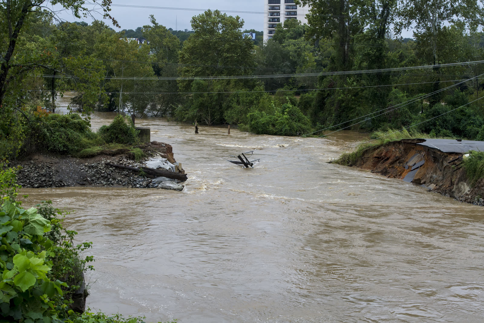
Breach in the Columbia Canal levee, Columbia, SC, October 5, 2015 — the flood that took out the capital's water supply
STORM ARCHIVE / 2015
OFFSHORE SC · 2015 · 155 mph

The 2015 South Carolina Floods

No landfall — 1,000-year rain event, Columbia to Charleston (Hurricane Joaquin offshore). NFIP take-up in the declared counties averaged about 5% — South Carolina's costliest flood hit the inland counties where almost no one had flood insurance

U.S. Army National Guard
CLASSIFICATION
OFFSHORE
PEAK WIND
155 mph
PRESSURE
931 mb (Joaquin peak, offshore)
DAMAGE
~$2B+ SC
DEATHS
19 SC
01 THE PATH

Where it hit, start to finish

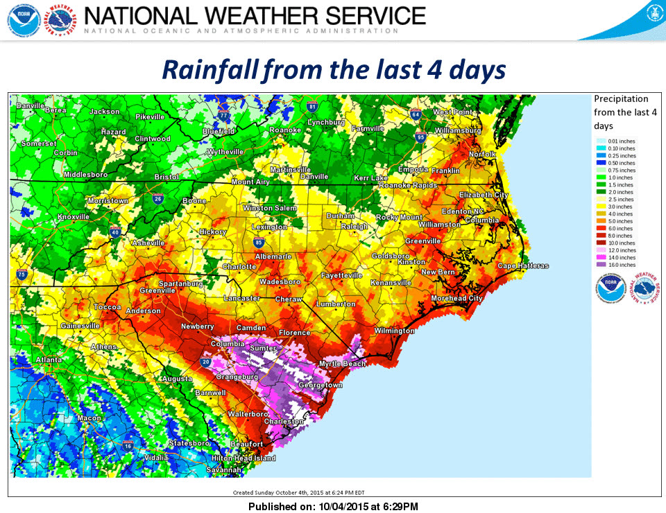
RAINFALL · OCT 1-5 · THE 2015 SOUTH CAROLINA FLOODSNOAA / WPC
October 1-5, 2015 rainfall across the Carolinas. The white core over the Midlands and Lowcountry topped 20 inches; Mount Pleasant recorded 26.88 inches. This is where the storm actually landed, on South Carolina, as rain.
Atlantic, near the Bahamas
JOAQUIN OFFSHORE - THE FIREHOSE

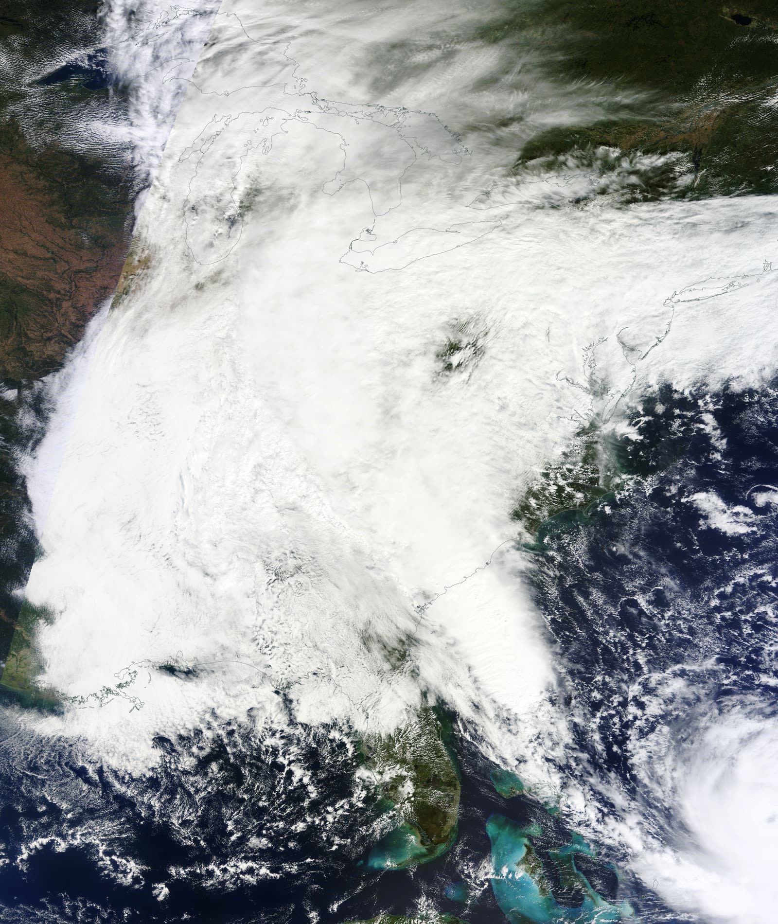
Hurricane Joaquin peaked at 155 mph over the Bahamas and never approached the US coast. But a stalled upper low over the Southeast tapped Joaquin's tropical moisture and aimed it — a 'firehose' of deep tropical air — at South Carolina for five straight days, October 1-5.

Columbia / Gills Creek
1,000-YEAR RAIN, DAMS DOWN THE CHAIN

Rain rates near Columbia exceeded the 1-in-1,000-year event. Gills Creek hit 17.08 feet — nearly double its 1997 record — and the chain of private dams along it failed in sequence. Statewide, several dozen dams breached or failed, including Semmes Lake Dam at Fort Jackson, where the dam-failure toll turned deadly.

Columbia, SC
CAPITAL LOSES ITS WATER

A breach in the Columbia Canal levee crippled the city's water system; Columbia went under a boil-water advisory and National Guard helicopters dropped sandbags into the canal. Forest Acres and the Gills Creek corridor took house-by-house losses.

I-95 corridor, Clarendon/Williamsburg counties
70 MILES OF INTERSTATE CLOSED

Rivers crossing the coastal plain shut I-95 for 70 miles between I-20 and I-26 for ten days. Road repairs eventually totaled $137 million, with 221 bridges affected and 18 needing replacement.

Lowcountry rivers
THE CREST MOVES DOWNSTREAM

For two weeks after the rain stopped, record crests rolled down the Black, Edisto, Santee, and Waccamaw basins, flooding towns like Kingstree and Givhans that had seen little rain damage — a second, slower disaster with its own claim dates.

Charleston / Mount Pleasant
26.88 INCHES AND A BLOCKED TIDE

Mount Pleasant recorded the event maximum, 26.88 inches; Charleston airport logged 11.5 inches in 24 hours on October 3. Rain falling on king-tide harbor levels left downtown Charleston's drainage nowhere to send the water. SC toll: 19 dead, about $2 billion-plus in damage.

02 THE RECORD IN IMAGES
ALL IMAGERY U.S. GOV / PUBLIC DOMAIN
SATELLITE NOAA / NASA
October 3, 2015: the stalled East Coast low with Hurricane Joaquin at lower right, firehosing tropical moisture into South Carolina
FLOOD U.S. Army National Guard
Levee breach near Columbia, October 5, 2015 — one of dozens of embankment and dam failures across the Midlands
AERIAL U.S. Army National Guard
SC and NC National Guard Black Hawks running rescue and levee-repair missions over the flood zone, October 6, 2015
DAMAGE FEMA / Patsy Lynch
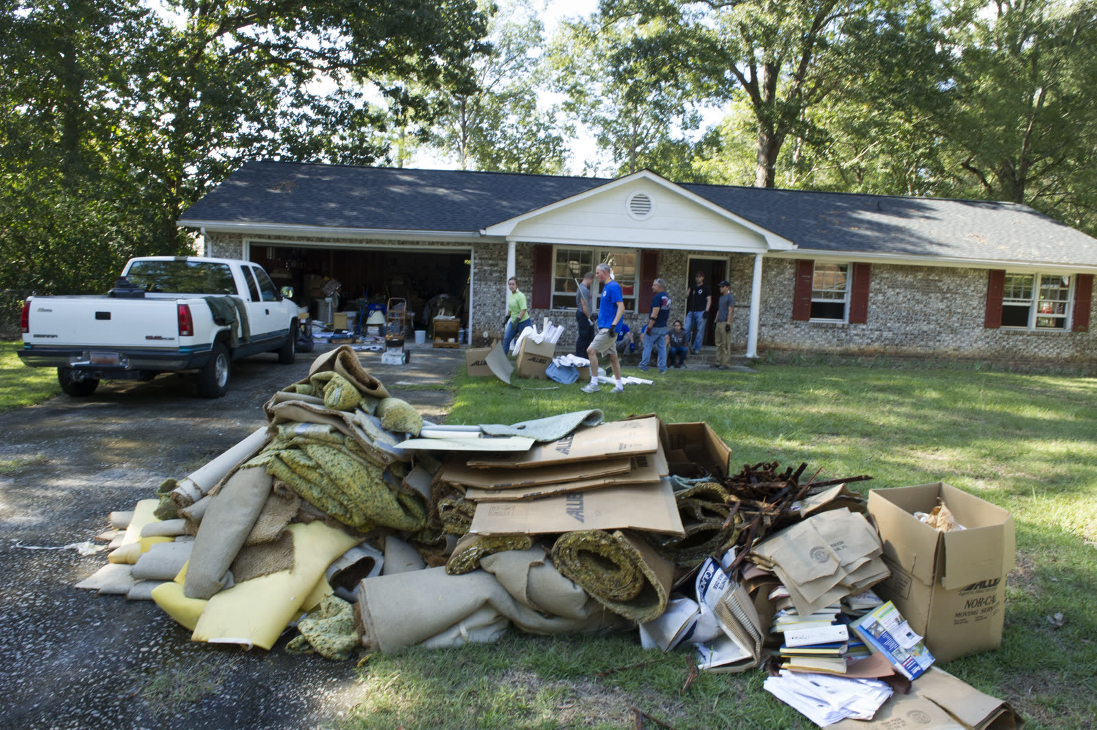
Residents of southeast Columbia gut flooded homes, October 11, 2015 — most had no flood policy behind the loss
FLOOD U.S. Air National Guard
SC Air National Guard members and volunteers help residents clear flood-ruined belongings, October 8, 2015

The storm

South Carolina's costliest flood came from a hurricane that never made landfall. In early October 2015, Hurricane Joaquin — a 155-mph Category 4 pounding the Bahamas — sat offshore while a cutoff upper-level low stalled over the Southeast. The low tapped Joaquin's tropical moisture plume and aimed it at South Carolina like a firehose. Training rain bands ran over the same ground for five days, October 1-5.

The totals broke the state's records: 26.88 inches at Mount Pleasant, 11.5 inches in 24 hours at Charleston airport on October 3, and rainfall around Columbia that exceeded the 1-in-1,000-year probability. This dossier treats the event page-style: the "storm" is the rain machine, and the track map shows Joaquin — the offshore engine that supplied it. Nineteen South Carolinians died, most in vehicles and in dam-failure flood waves, and damage reached roughly $2 billion or more statewide.
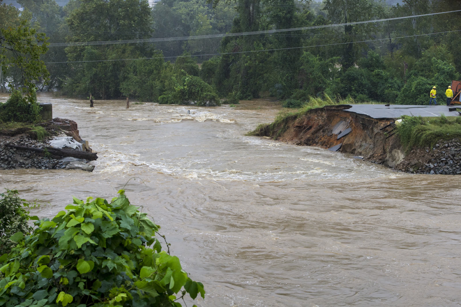
Levee breach near Columbia, October 5, 2015 — one of dozens of embankment and dam failures across the Midlands
Levee breach near Columbia, October 5, 2015 — one of dozens of embankment and dam failures across the Midlands U.S. Army National Guard

The damage

The Midlands failed first. Gills Creek in Columbia rose to 17.08 feet — almost double its previous record — and the chain of small private dams along the creek failed one after another. Statewide, dozens of regulated dams breached or collapsed (case studies count 30-plus, with later tallies higher), including federally owned Semmes Lake Dam at Fort Jackson. A breach in the Columbia Canal levee knocked out the capital's water supply; the city boiled water for days while Guard helicopters dropped sandbags into the canal. Forest Acres and the Gills Creek corridor lost homes by the street.

The disaster then moved downstream. I-95 closed for 70 miles between I-20 and I-26. Record crests rolled through the Black, Edisto, Santee, and Waccamaw basins for two weeks, flooding Lowcountry towns well after skies cleared. In Charleston, the event maximum rain fell onto king-tide harbor levels that blocked the city's drainage. Infrastructure alone was staggering: 221 bridges affected, 18 replaced, $137 million in road repairs.

SC and NC National Guard Black Hawks running rescue and levee-repair missions over the flood zone, October 6, 2015
SC and NC National Guard Black Hawks running rescue and levee-repair missions over the flood zone, October 6, 2015 U.S. Army National Guard

The insurance aftermath

The 2015 flood is the defining data point for South Carolina's inland flood-insurance gap. NFIP penetration in the counties under the federal declaration (DR-4241) averaged about 5%, and nearly 90% of the state's flood policies sat in coastal counties — but the water fell on Columbia, Sumter, Kingstree, and the inland river basins. Aon Benfield put economic losses above $1 billion early on, noting a large share was uninsured homeowners; homeowners policies denied the losses under the standard flood exclusion, exactly as written. For most flooded households, the recovery stack was FEMA Individual Assistance grants (capped in the low tens of thousands) and SBA loans — debt, not indemnity.

Fault lines opened around the dams. Because much of the destruction arrived as dam-failure waves rather than rising rain water, litigation followed within weeks: negligence suits in Richland County against dam owners and entities controlling drainage, and federal claims over Semmes Lake Dam at Fort Jackson — including a wrongful-death suit and downstream property claims seeking $20 million-plus. The suits highlighted a policyholder-relevant distinction: a flood exclusion bars the first-party claim, but a negligent dam owner can be a third-party recovery route.

Regulatory fallout ran two directions. The state's dam-safety program — exposed as one of the nation's thinnest — got new funding and inspections, and thousands of repetitive-loss and newly mapped properties entered the NFIP conversation. When Matthew (2016) and Florence (2018) flooded many of the same basins, repetitive-loss dynamics and slightly higher take-up were the direct legacy of 2015.
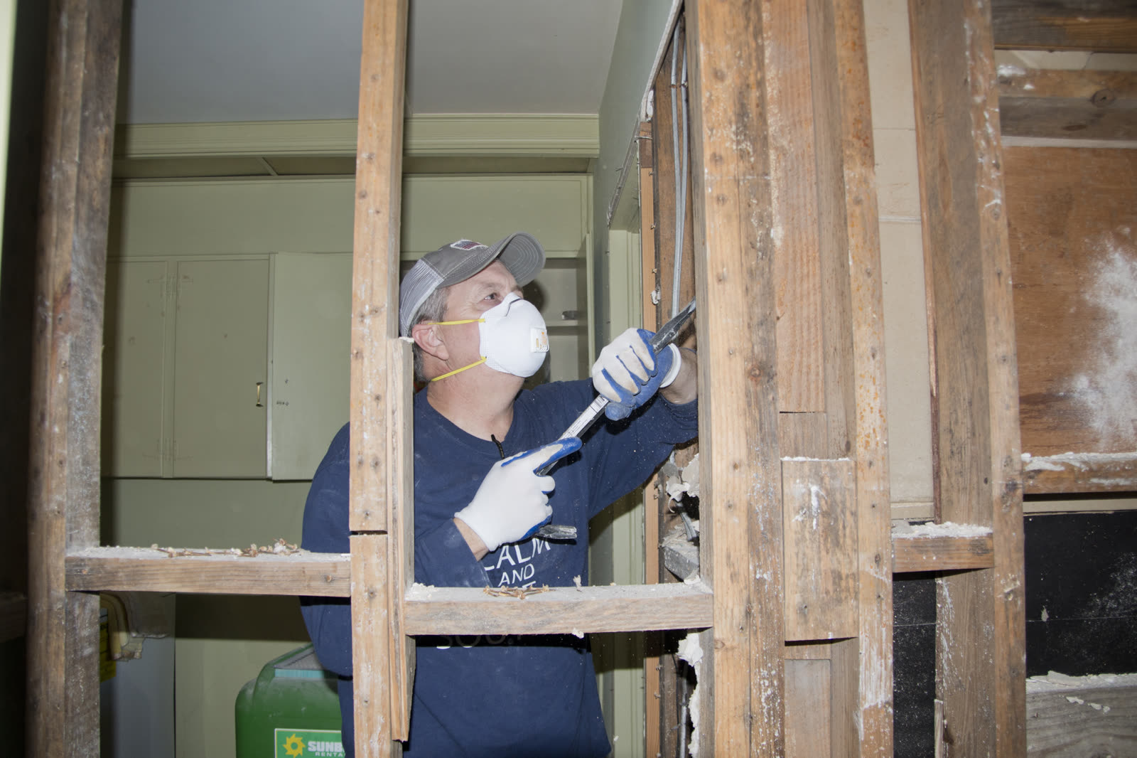
Residents of southeast Columbia gut flooded homes, October 11, 2015 — most had no flood policy behind the loss
Residents of southeast Columbia gut flooded homes, October 11, 2015 — most had no flood policy behind the loss FEMA / Patsy Lynch

What policyholders learned

  • The flood exclusion does not care where the water came from. Rain, dam failure, canal breach, blocked drainage — all denied as flood under homeowners policies. Only a flood policy responded, and 95% of affected households had none.
  • Inland ZIP codes were the uninsured core. Flood insurance concentrated at the beach; the loss concentrated in Columbia. Low-cost preferred-risk NFIP policies were available in most flooded areas for a few hundred dollars a year.
  • Dam-failure losses opened a second recovery path. Owners downstream of failed private dams pursued the dam owners in tort — slower than insurance, but it was the only route to full indemnity for the uninsured.
  • FEMA grants are a floor, not a settlement. IA checks covered emergency repairs, not rebuilding; households that treated the grant as the final number abandoned recoverable amounts from SBA appeals, charity programs, and litigation.
  • Delayed downstream crests reset claim clocks. Lowcountry homes flooded up to two weeks after the rain; documentation tying the loss date to the crest — not the storm — kept those claims and assistance applications clean.

Independent informational resource — not legal advice. Damage figures are nominal (not inflation-adjusted) unless noted. Insurance-law summaries are drafted for education; consult an attorney about your specific claim.

EVENT-MAXIMUM RAINFALL · THE 2015 SOUTH CAROLINA FLOODS · 2015
26.88 in
AT MOUNT PLEASANT, SC
HURRICANELAW.PRO FIELD FOOTAGE
03 THE FULL RECORD

Every official record of The 2015 South Carolina Floods

Reports, imagery archives, flood data, and claims records — straight from the agencies.

OUR LAW FIRM PARTNER · HALVERSEN LAW
The 2015 South Carolina Floods claim denied?
CALL FL941-390-3233CALL SC843-542-0454FREE CLAIM REVIEW
RELATED GUIDES
HurricaneLaw.Pro HURRICANELAW.PRO

The independent policyholder resource for Florida & South Carolina — storm archive, coverage law, denials, bad faith, and the complete claims playbook. 51 storms · 46 carriers · 97 public-adjuster firms · 37 city guides.

▸ SEE THE FULL SITE MAP — EVERY PAGE →
STORM ALERTS SOURCED FROM NOAA / NHC
SOUTH CAROLINA
496 Bramson Court, Suite 100
Mount Pleasant, SC 29464
CALL OR TEXT
FLORIDA
Tampa, FL
CALL OR TEXT
CLAIMS 9
DENIALS 8
BAD FAITH 7
COVERAGE 12
COMMERCIAL 8
ROOFS 8
TREES 5
DIRECTORIES
STORMS 51
WEATHER
NEWS & SITE 19
STORM ARCHIVE, CITIES & NEWS
Most recent below. Every storm dossier, city resource, and article is on its hub (linked at each heading) or the grouped site map →. All 46 carriers and 97 public-adjuster firms are in the Directories column above.
STORM ARCHIVE · 51 →
Hurricane Debby 2024Hurricane Helene 2024Hurricane Milton 2024Hurricane Idalia 2023Hurricane Ian 2022Hurricane Nicole 2022Hurricane Ida 2021Hurricane Laura 2020 View all 51 →
FLORIDA CITY RESOURCES · 29 →
Boca RatonBradentonCape CoralClearwaterDaytona BeachDestinFort LauderdaleFort Myers View all 29 →
SOUTH CAROLINA CITY RESOURCES · 8 →
BeaufortCharlestonColumbiaFlorenceGreenvilleHilton Head IslandMount PleasantMyrtle Beach
NEWS & UPDATES · 19 →

HurricaneLaw.Pro is an independent informational resource, not a law firm. Coverage summaries, policy-language quotations, dollar figures, deadlines, and chart examples throughout this site are general information based on typical or standard policy forms and are illustrative only — they are not a quote, a guarantee of coverage, or a promise of any outcome. Every insurance policy is different: your own policy, endorsements, and state law control, so read your policy and confirm current statutes. Weather imagery courtesy of NOAA, the National Hurricane Center, and the National Weather Service. Legal services are provided by our law firm partner, Halversen Law. Nothing on this site is legal advice; consult an attorney about your specific claim.

PrivacyTermsDisclaimerAboutContact
© 2026 HURRICANELAW.PRO — ALL RIGHTS RESERVED 27.9°N 82.5°W · ATLANTIC BASIN MONITOR
OUR LAW FIRM PARTNER
Halversen Law LICENSED · FLORIDA & SOUTH CAROLINA

All legal matters on this site are referred to and handled by our law firm partner, Halversen Law, a licensed law firm in Florida and South Carolina. HurricaneLaw.Pro is an informational resource and is not itself a law firm.

FREE CASE REVIEW