
PROPERTY-INSURANCE CLAIM HELP · FL & SC FL CITIESSC CITIESGUIDESTATESNEWSSITE MAPABOUT
HurricaneLaw.Pro HURRICANELAW.PRO
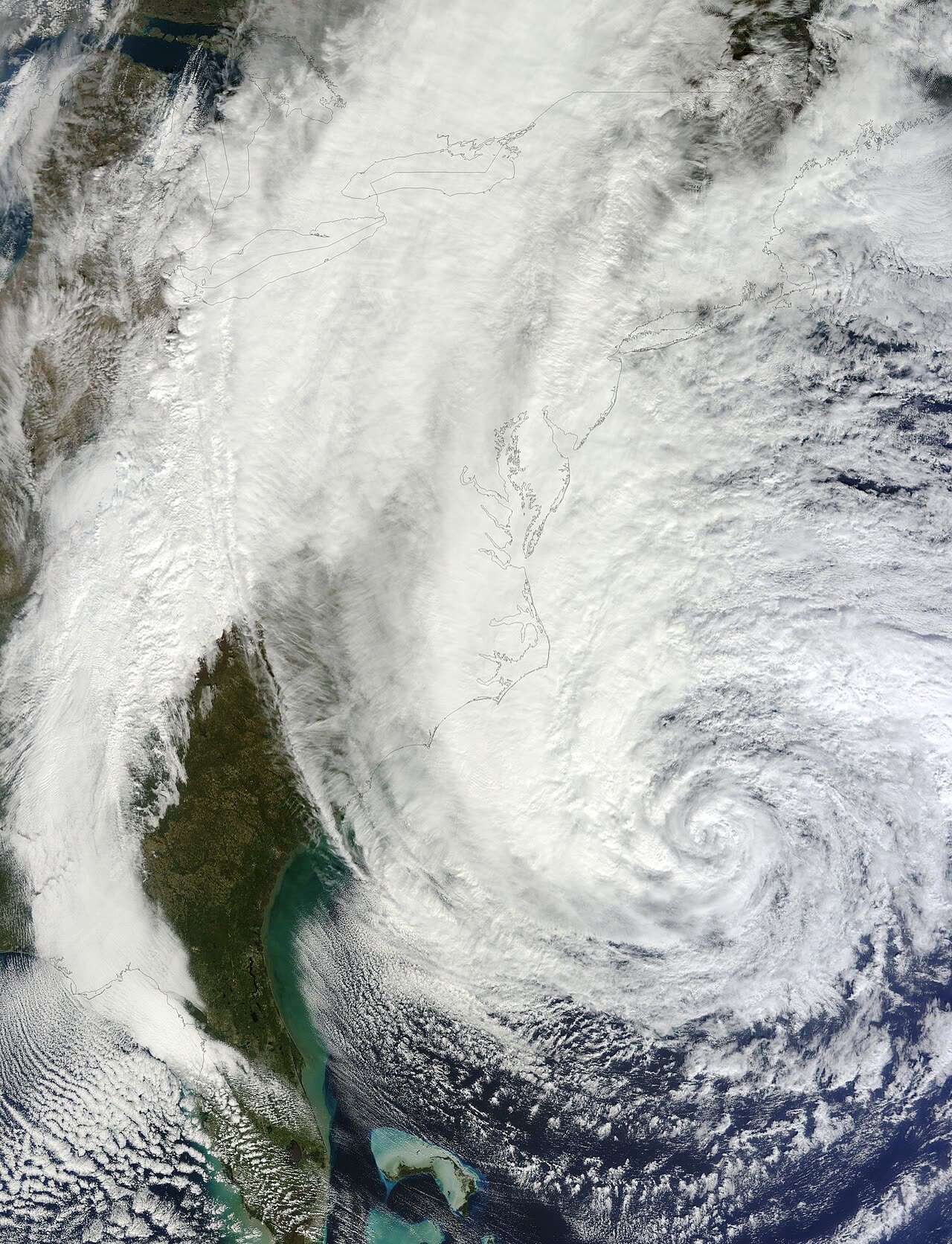
Sandy spanning the western Atlantic the day before landfall, October 28, 2012 — tropical-storm-force winds covered nearly 1,000 miles
STORM ARCHIVE / 2012 LANDFALL 39.4°N 74.4°W
POST-TROPICAL US · 2012 · 115 mph

Hurricane Sandy

Brigantine, NJ · 2012-10-29. Post-tropical at landfall, so hurricane deductibles were voided — then FEMA reopened ~142,000 NFIP claims over altered engineering reports

NOAA / NASA (GOES-13)
CLASSIFICATION
POST-TROPICAL
PEAK WIND
115 mph
PRESSURE
945 mb (landfall)
STORM SURGE
12.65 ft
DAMAGE
$65B
DEATHS
159
01 THE PATH

Where it hit, start to finish

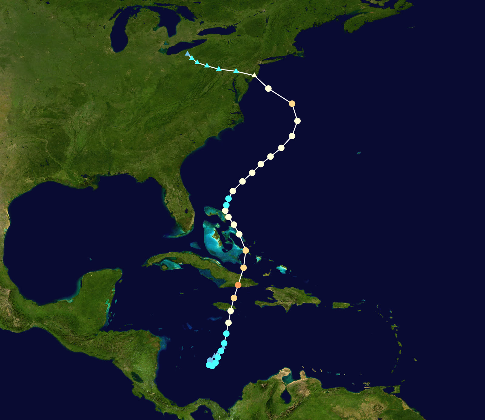
OFFSHORE TRACK · HURRICANE SANDYNOAA / NHC (best-track data)
Best track of Hurricane Sandy, October 22-29, 2012, including the unprecedented left turn into New Jersey
Jamaica / Cuba
CARIBBEAN HURRICANE — PEAK 115 MPH

Sandy formed October 22, crossed Jamaica as a Category 1, then hit Santiago de Cuba October 25 at peak intensity — a 115 mph Category 3.

Western Atlantic
THE HYBRID GIANT

Interacting with a trough, Sandy grew into the largest Atlantic hurricane on record by wind-field diameter — tropical-storm-force winds spanning roughly 1,000 miles — while turning left toward New Jersey, a track without modern precedent.

Brigantine, NJ
POST-TROPICAL LANDFALL — 945 MB

Declared post-tropical about 2.5 hours before landfall, Sandy came ashore near Brigantine at 7:30 p.m. EDT October 29 with 80 mph winds and 945 mb — the lowest pressure ever recorded at landfall north of Cape Hatteras.

Jersey Shore
BARRIER ISLANDS BREACHED

Surge and battering waves breached barrier islands, buried towns in sand, and put the Seaside Heights roller coaster in the ocean. Mantoloking, Ortley Beach, Union Beach, and the back-bay towns took catastrophic structural loss.

New York City / Long Island
RECORD SURGE — SUBWAYS DROWNED

Storm surge reached 12.65 ft at Kings Point and drove record water levels at The Battery. Lower Manhattan, Red Hook, Staten Island's east shore, and the Rockaways flooded; a fire leveled 100+ homes in Breezy Point; subway and road tunnels filled with seawater.

Northeast / Appalachians
8.5M WITHOUT POWER — BLIZZARD INLAND

Sandy's circulation dumped feet of snow in West Virginia and cut power to 8.5 million customers across 21 states. U.S. toll: 159 deaths and about $65 billion in damage.

02 THE RECORD IN IMAGES
ALL IMAGERY U.S. GOV / PUBLIC DOMAIN
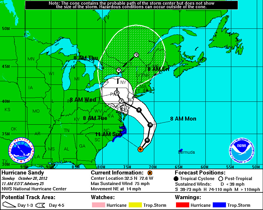
CONE NOAA / NHC
NHC forecast cone showing Sandy's forecast bend into the mid-Atlantic coast
AERIAL U.S. Air Force / Master Sgt. Mark C. Olsen
The Casino Pier roller coaster in the Atlantic at Seaside Heights, NJ — shot during a National Guard search-and-rescue flight, October 30, 2012
AERIAL U.S. Air Force
Breached and buried New Jersey shore neighborhoods seen from an Army search-and-rescue flight, October 30, 2012
OTHER U.S. Coast Guard
Coast Guard rescue of the HMS Bounty crew, abandoned ship in Sandy's seas off North Carolina, October 29, 2012
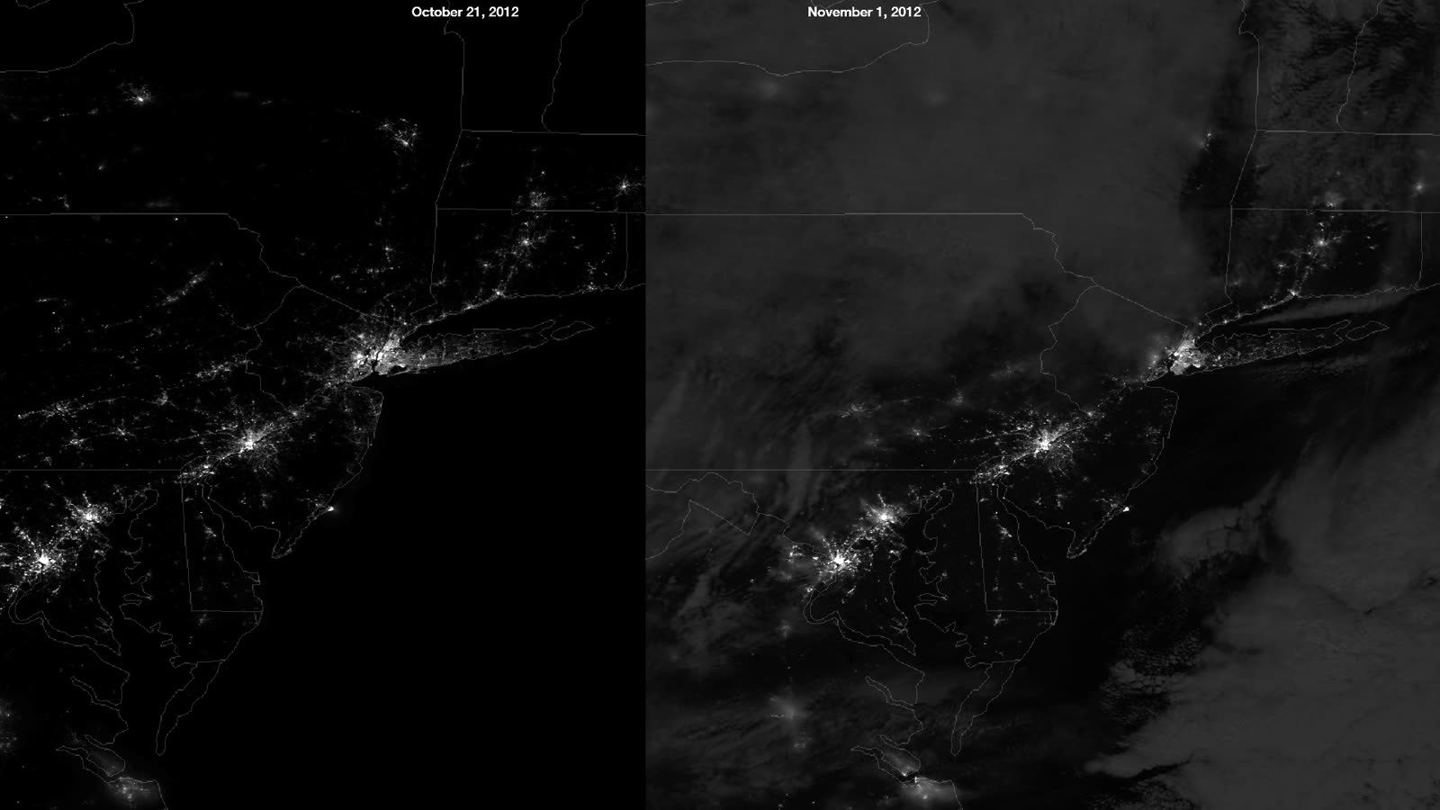
MAP NASA
Satellite night-lights comparison of the New York-New Jersey blackout after Sandy — 8.5 million customers lost power

The storm

Sandy formed in the Caribbean on October 22, 2012, crossed Jamaica, and hit Santiago de Cuba as a 115 mph Category 3 — its lifetime peak. What happened next had no modern precedent. Interacting with a deep trough, Sandy ballooned into the largest Atlantic hurricane on record by wind-field diameter — tropical-storm-force winds spanning roughly 1,000 miles — and turned left, west, into the mid-Atlantic coast.

About 2.5 hours before landfall, the National Hurricane Center reclassified Sandy as a post-tropical cyclone. It came ashore near Brigantine, New Jersey at 7:30 p.m. EDT on October 29 with 80 mph winds and a 945 mb pressure — the lowest landfall pressure on record north of Cape Hatteras. The wind field pushed a record surge into the New York-New Jersey coast: 12.65 feet of surge at Kings Point, record water levels at The Battery. The U.S. toll: 159 deaths, about $65 billion in damage, 8.5 million customers without power across 21 states.
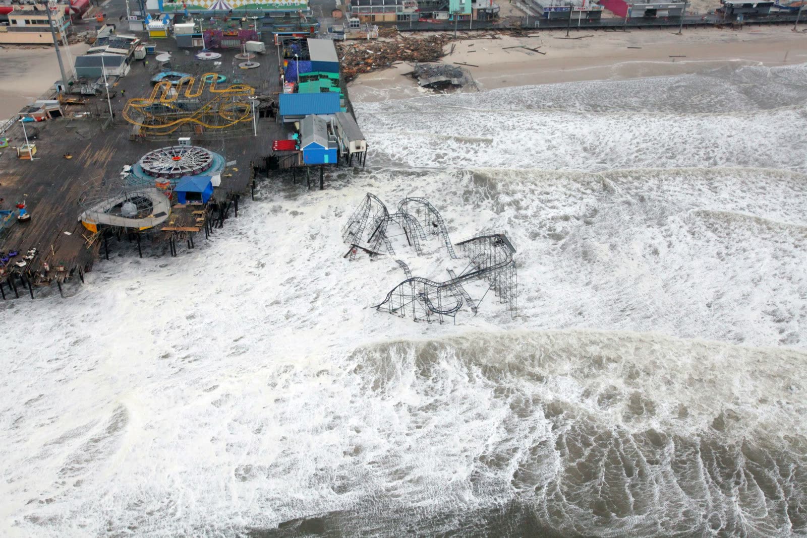
The Casino Pier roller coaster in the Atlantic at Seaside Heights, NJ — shot during a National Guard search-and-rescue flight, October 30, 2012
The Casino Pier roller coaster in the Atlantic at Seaside Heights, NJ — shot during a National Guard search-and-rescue flight, October 30, 2012 U.S. Air Force / Master Sgt. Mark C. Olsen

The damage

The Jersey Shore took structural catastrophe: barrier islands breached at Mantoloking, ocean-front blocks gutted at Ortley Beach and Union Beach, the Seaside Heights roller coaster standing in the Atlantic. In New York City, seawater filled subway tunnels, road tunnels, and electrical substations; Staten Island's east shore and the Rockaways flooded to rooflines in places, and a wind-driven fire during the flood destroyed more than 100 homes in Breezy Point. Back-bay flooding damaged tens of thousands of homes across Long Island, coastal Connecticut, and the New Jersey bayshore. Inland, Sandy's circulation dropped feet of snow on West Virginia.
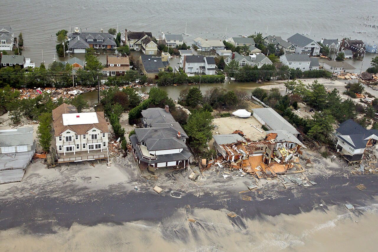
Breached and buried New Jersey shore neighborhoods seen from an Army search-and-rescue flight, October 30, 2012
Breached and buried New Jersey shore neighborhoods seen from an Army search-and-rescue flight, October 30, 2012 U.S. Air Force

The insurance aftermath

Sandy's timing — reclassified post-tropical minutes before landfall, in insurance terms — moved billions of dollars. Hurricane deductibles in the Northeast (typically 1-5% of dwelling limits) trigger only for a named hurricane at landfall. Because NWS said Sandy wasn't one, governors and insurance regulators in New York, New Jersey, Connecticut, and other states barred carriers from applying hurricane deductibles. Homeowners paid flat dollar deductibles instead, often saving five figures per claim.

Flood did the most damage, and flood meant the NFIP. Policyholders filed roughly 144,000 Sandy flood claims; the program paid on the order of $8 billion. Then the program's credibility broke. In Raimey v. Wright National Flood (E.D.N.Y. 2014), a federal magistrate judge found that an engineering firm's field report — which attributed a Long Beach home's structural damage to Sandy — had been secretly rewritten to blame long-term settlement, and called the practice "concealed by design." Discovery in other cases surfaced the same pattern: altered engineer reports used to deny structural claims, drafted by firms working for the NFIP's Write-Your-Own carriers. A 60 Minutes investigation put the scheme on national television in early 2015.

FEMA's response was unprecedented: it settled the pending federal litigation and in May 2015 opened a review offering every Sandy NFIP claimant — letters went to roughly 142,000 policyholders — the chance to have their claim re-examined. The review ultimately paid out hundreds of millions of additional dollars, and a later DHS Inspector General audit criticized the review's own controls in both directions. Congressional reforms of WYO engineer-report handling followed.

Sandy also drove the two-year runout of claim fights over "earth movement" exclusions, proof-of-loss deadlines (the NFIP's strict 60-day requirement, repeatedly extended by FEMA for Sandy), and New York's creation of a mandatory claims-handling timeline for storm claims.
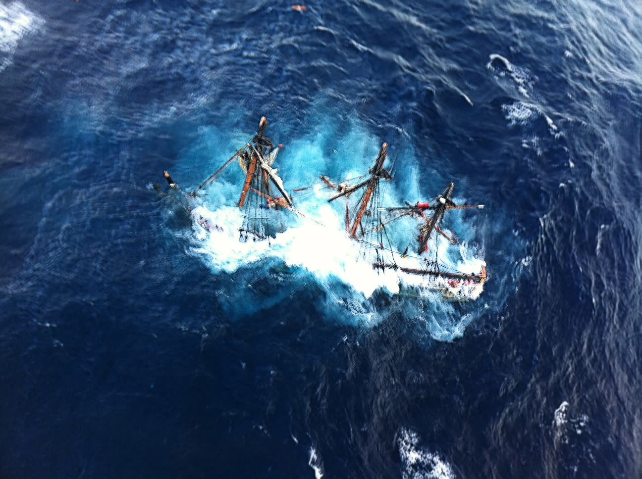
Coast Guard rescue of the HMS Bounty crew, abandoned ship in Sandy's seas off North Carolina, October 29, 2012
Coast Guard rescue of the HMS Bounty crew, abandoned ship in Sandy's seas off North Carolina, October 29, 2012 U.S. Coast Guard

What policyholders learned

  • Storm classification is a coverage term. Post-tropical status voided hurricane deductibles across three states — the label on the storm, not the damage, set what policyholders owed out of pocket.
  • Expert reports can be challenged. The engineer-report scandal proved that a denial letter's "structural damage pre-existed the storm" conclusion is evidence, not fact. Policyholders who obtained their full claim file and the draft reports found the alterations.
  • NFIP deadlines are unforgiving. The 60-day proof-of-loss rule barred claims even where damage was undisputed; extensions came only because FEMA formally granted them.
  • Reopened is not repaid. Only a fraction of eligible policyholders entered FEMA's Sandy review; those who did routinely recovered more. Declining to re-open a shorted claim left money unclaimed.
  • Flood policies never covered what owners assumed. NFIP dwelling limits ($250,000 max), basement exclusions, and no additional-living-expense coverage surprised thousands of Northeast policyholders who had never read the policy before 2012.

Independent informational resource — not legal advice. Damage figures are nominal (not inflation-adjusted) unless noted. Insurance-law summaries are drafted for education; consult an attorney about your specific claim.

AT LANDFALL · HURRICANE SANDY · 2012
12.65 ft
OF STORM SURGE · KINGS POINT, NY
HURRICANELAW.PRO FIELD FOOTAGE
03 THE FULL RECORD

Every official record of Sandy

Reports, imagery archives, flood data, and claims records — straight from the agencies.

OUR LAW FIRM PARTNER · HALVERSEN LAW
Sandy claim denied?
CALL FL941-390-3233CALL SC843-542-0454FREE CLAIM REVIEW
RELATED GUIDES
HurricaneLaw.Pro HURRICANELAW.PRO

The independent policyholder resource for Florida & South Carolina — storm archive, coverage law, denials, bad faith, and the complete claims playbook. 51 storms · 46 carriers · 97 public-adjuster firms · 37 city guides.

▸ SEE THE FULL SITE MAP — EVERY PAGE →
STORM ALERTS SOURCED FROM NOAA / NHC
SOUTH CAROLINA
496 Bramson Court, Suite 100
Mount Pleasant, SC 29464
CALL OR TEXT
FLORIDA
Tampa, FL
CALL OR TEXT
CLAIMS 9
DENIALS 8
BAD FAITH 7
COVERAGE 12
COMMERCIAL 8
ROOFS 8
TREES 5
DIRECTORIES
STORMS 51
WEATHER
NEWS & SITE 19
STORM ARCHIVE, CITIES & NEWS
Most recent below. Every storm dossier, city resource, and article is on its hub (linked at each heading) or the grouped site map →. All 46 carriers and 97 public-adjuster firms are in the Directories column above.
STORM ARCHIVE · 51 →
Hurricane Debby 2024Hurricane Helene 2024Hurricane Milton 2024Hurricane Idalia 2023Hurricane Ian 2022Hurricane Nicole 2022Hurricane Ida 2021Hurricane Laura 2020 View all 51 →
FLORIDA CITY RESOURCES · 29 →
Boca RatonBradentonCape CoralClearwaterDaytona BeachDestinFort LauderdaleFort Myers View all 29 →
SOUTH CAROLINA CITY RESOURCES · 8 →
BeaufortCharlestonColumbiaFlorenceGreenvilleHilton Head IslandMount PleasantMyrtle Beach
NEWS & UPDATES · 19 →

HurricaneLaw.Pro is an independent informational resource, not a law firm. Coverage summaries, policy-language quotations, dollar figures, deadlines, and chart examples throughout this site are general information based on typical or standard policy forms and are illustrative only — they are not a quote, a guarantee of coverage, or a promise of any outcome. Every insurance policy is different: your own policy, endorsements, and state law control, so read your policy and confirm current statutes. Weather imagery courtesy of NOAA, the National Hurricane Center, and the National Weather Service. Legal services are provided by our law firm partner, Halversen Law. Nothing on this site is legal advice; consult an attorney about your specific claim.

PrivacyTermsDisclaimerAboutContact
© 2026 HURRICANELAW.PRO — ALL RIGHTS RESERVED 27.9°N 82.5°W · ATLANTIC BASIN MONITOR
OUR LAW FIRM PARTNER
Halversen Law LICENSED · FLORIDA & SOUTH CAROLINA

All legal matters on this site are referred to and handled by our law firm partner, Halversen Law, a licensed law firm in Florida and South Carolina. HurricaneLaw.Pro is an informational resource and is not itself a law firm.

FREE CASE REVIEW