PROPERTY-INSURANCE CLAIM HELP · FL & SC FL CITIESSC CITIESGUIDESTATESNEWSSITE MAPABOUT
HurricaneLaw.Pro HURRICANELAW.PRO
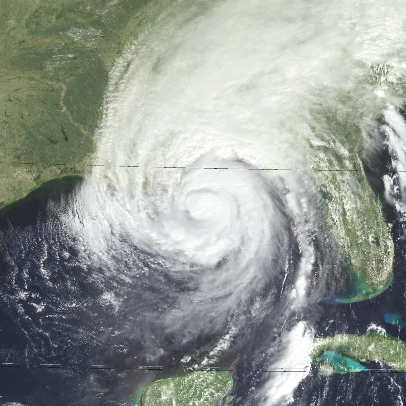
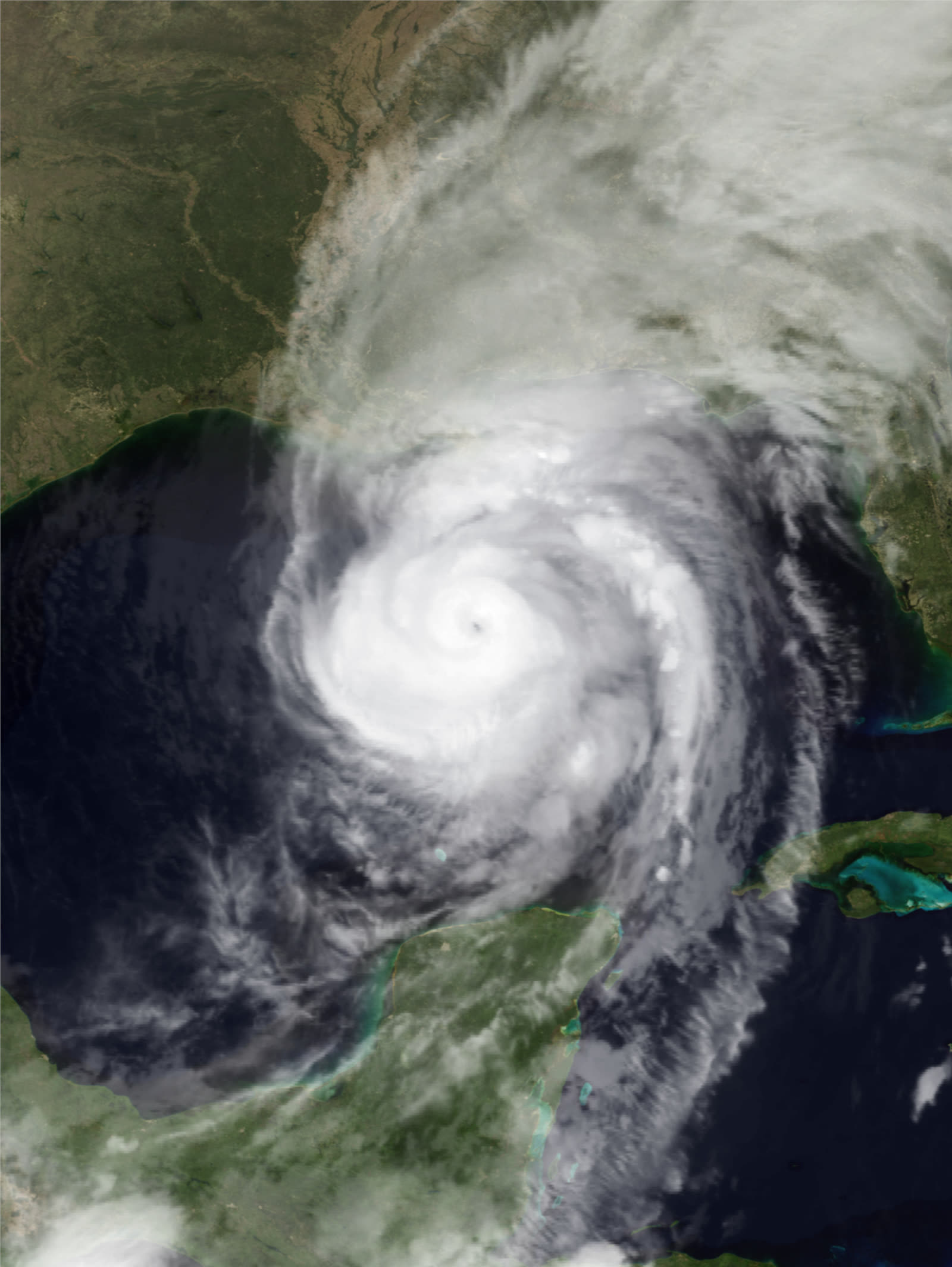
Opal near Category 4 peak intensity (150 mph, 916 mb) in the central Gulf, hours before its run at the Panhandle, October 4, 1995
STORM ARCHIVE / 1995 LANDFALL 30.3°N 87.1°W
CAT 3 AT LANDFALL PEAK CAT 4 FL · 1995 · 150 mph

Hurricane Opal

Landfall: Pensacola Beach, FL · 1995-10-04. $2.1B in insured losses three years after Andrew — Opal's claims drove $117M in wind-pool assessments and swelled the FWUA

NOAA / NESDIS
AT LANDFALL
CAT 3
PEAK INTENSITY
CAT 4 · 150 mph
PRESSURE
916 mb (peak)
STORM SURGE
8-15 ft
DAMAGE
$5.1B US
DEATHS
9 US
01 THE PATH

Where it hit, start to finish

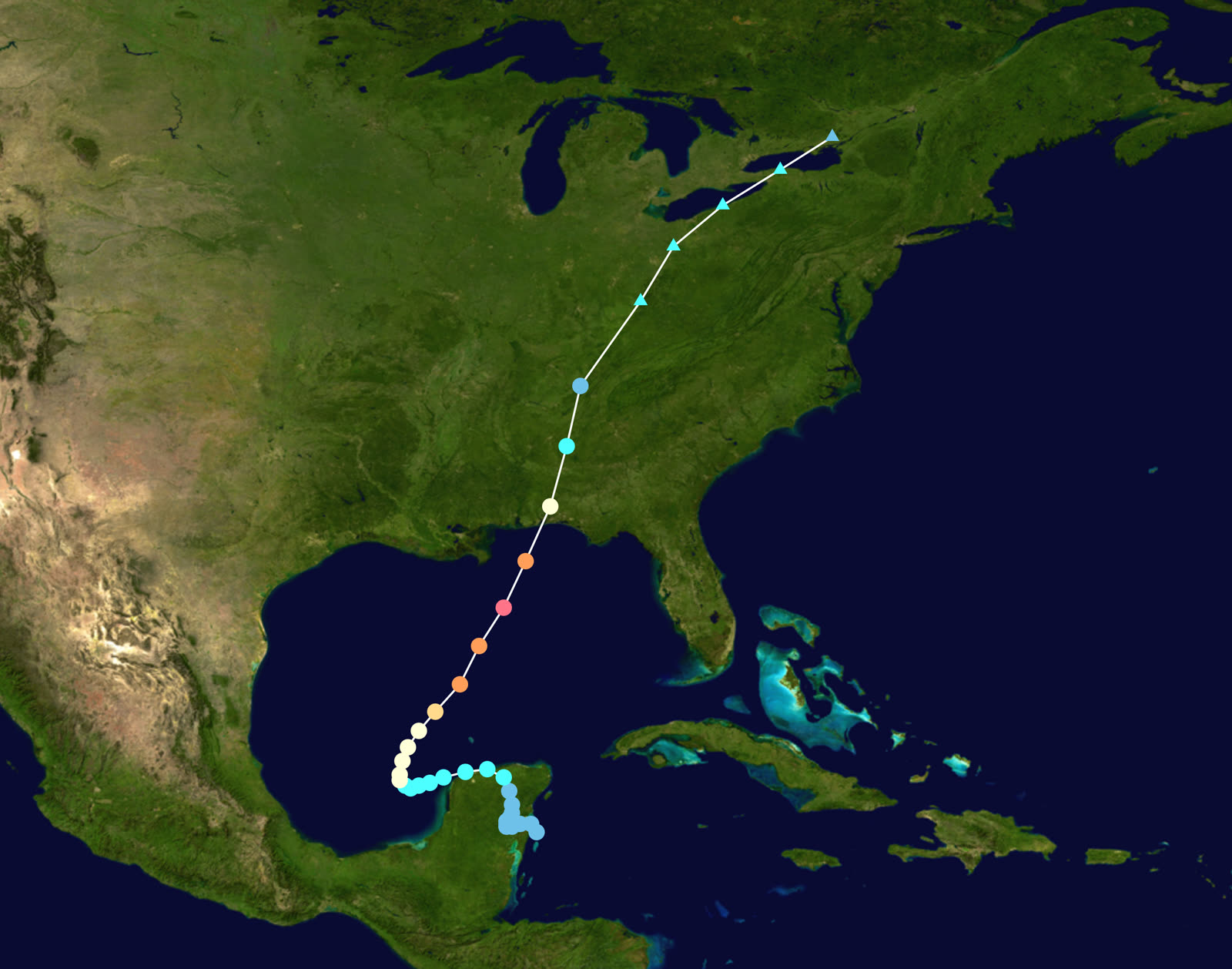
TRACK · HURRICANE OPALNOAA / NHC (best-track data)
Best track of Hurricane Opal, September 27 - October 6, 1995 - from the Yucatan to the Panhandle to Ontario
Yucatan Peninsula
SLOW START, DEADLY RAIN

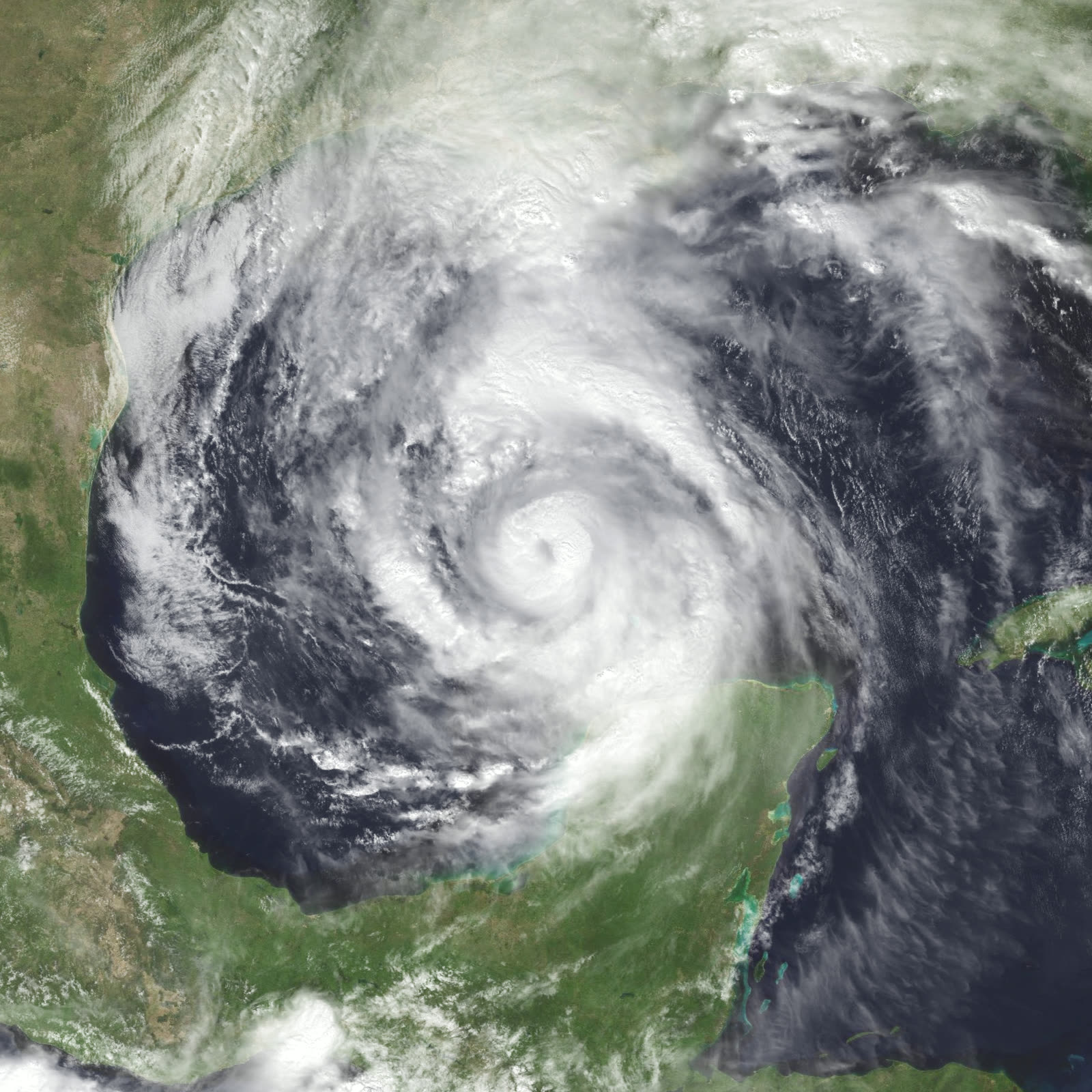
Opal formed near the Yucatan on September 27, 1995, and drifted for days, flooding Guatemala and Mexico - 50 deaths - before moving into the Gulf.

Central Gulf of Mexico
916 MB - RAPID INTENSIFICATION

Over a warm eddy on October 3-4, Opal exploded from Category 1 to Category 4, peaking at 150 mph and 916 mb - at the time the most intense Category 4 Atlantic hurricane on record by pressure. The overnight jump caught the coast mid-evacuation.

US 98 corridor
EVACUATION GRIDLOCK

An estimated 100,000 people evacuated the Gulf Coast; pre-dawn traffic jammed US 98 and I-10 as Opal accelerated north at over 20 mph. Many residents rode out the storm in traffic or turned back.

Pensacola Beach / Navarre Beach, FL
CAT 3 LANDFALL - CAT 4 SURGE

Landfall about 6 p.m. CDT October 4 between Pensacola Beach and Navarre Beach at 115 mph. An eyewall replacement cycle had weakened the wind, but the surge built at Category 4 strength arrived intact: 8-15 feet along the Panhandle, sweeping away nearly a mile of US 98 near Eglin AFB.

Escambia-Bay counties, FL
300 HOMES DESTROYED

Across Escambia, Santa Rosa, Okaloosa, and Bay counties, nearly 300 homes were destroyed and 1,000 more suffered major damage. Florida damage alone reached $2.1 billion; US total damage ran to about $5.1 billion with 9 direct US deaths.

Alabama / Georgia / inland
INLAND WIND TO ONTARIO

A then-record 476,000 Alabama customers lost power; Atlanta lost over 4,000 trees and $50 million in pecan crops. Opal stayed a hurricane well inland, went extratropical October 5, and dissipated over Ontario October 6.

02 THE RECORD IN IMAGES
ALL IMAGERY U.S. GOV / PUBLIC DOMAIN
SATELLITE NOAA / NESDIS
Opal beginning rapid intensification over the warm Gulf, October 3, 1995 - it deepened to 916 mb within a day
SATELLITE NOAA / NESDIS
Opal near landfall as a weakening Category 3, late afternoon October 4 - the surge it built at Category 4 strength arrived anyway
DAMAGE NOAA
Gulf-front buildings wrecked by Opal's surge; nearly 300 Panhandle homes were destroyed and 1,000 more took major damage
MAP NOAA / WPC
Rainfall totals from Opal across the eastern US as it raced inland to Ontario

The storm

Opal formed near the Yucatan on September 27, 1995, and spent days as a disorganized rainmaker, killing 50 people in Guatemala and Mexico. Then it moved over a warm eddy in the central Gulf and became a different storm.

Overnight on October 3–4, Opal jumped from Category 1 to Category 4, peaking at 150 mph with a 916 mb pressure — at the time the most intense Category 4 Atlantic hurricane on record by pressure. The intensification happened while the Panhandle slept; morning evacuees hit gridlock on US 98 and I-10 as the storm accelerated north at more than 20 mph.

An eyewall replacement cycle weakened Opal to Category 3 (115 mph) before landfall between Pensacola Beach and Navarre Beach around 6 p.m. CDT on October 4. The wind weakened; the surge did not. Water built during the Category 4 phase came ashore at 8 to 15 feet along the Panhandle. Opal raced inland, stayed at hurricane strength deep into Alabama, and dissipated over Ontario on October 6. US toll: 9 direct deaths, about $5.1 billion in damage — $2.1 billion of it in Florida.

Opal near landfall as a weakening Category 3, late afternoon October 4 - the surge it built at Category 4 strength arrived anyway
Opal near landfall as a weakening Category 3, late afternoon October 4 - the surge it built at Category 4 strength arrived anyway NOAA / NESDIS

The damage

Surge did the signature damage. Nearly a mile of US 98 near Eglin Air Force Base was destroyed outright. Gulf-front structures from Pensacola Beach through Navarre, Fort Walton Beach, and Destin were gutted or swept off foundations; across Escambia, Santa Rosa, Okaloosa, and Bay counties, nearly 300 homes were destroyed and 1,000 more took major damage.

The contrast with 1975 was measurable: post-Opal engineering surveys found buildings permitted under the post-Eloise Coastal Construction Control Line — elevated, pile-founded, behind the setback — survived at far higher rates than pre-CCCL construction on the same beaches. Inland, wind was the story: a then-record 476,000 customers lost power in Alabama, and Atlanta lost more than 4,000 trees.
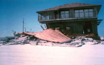
Gulf-front buildings wrecked by Opal's surge; nearly 300 Panhandle homes were destroyed and 1,000 more took major damage
Gulf-front buildings wrecked by Opal's surge; nearly 300 Panhandle homes were destroyed and 1,000 more took major damage NOAA

The insurance aftermath

Opal hit an insurance market still in triage from Andrew (1992). Insured US losses reached about $2.1 billion — at the time one of the five costliest US hurricanes for insurers — landing on carriers already shrinking their Florida coastal books.

The stress showed in the state's residual mechanisms. The Florida Windstorm Underwriting Association — the wind pool covering coastal properties private carriers refused — levied $117 million in assessments on the industry for its 1995 losses from Erin and Opal. Those assessments were passed through to policyholders statewide as surcharges, an early demonstration of how Florida socializes coastal wind losses. The FWUA then grew rapidly after 1995: eligibility expansions, continued unavailability of private windstorm coverage in the most exposed areas, and carriers' "accelerated exposure reduction" plans pushed more Panhandle and coastal risk into the pool. That growth track led to the FWUA's 2002 merger into Citizens Property Insurance Corporation — today's insurer of last resort.

Claims themselves split on the wind/water line. With surge doing the beachfront destruction and landfall winds a category below the surge's strength, carriers attributed slab-level losses to excluded flood; NFIP policies, where owners had them, capped out well below Gulf-front rebuild costs. The evacuation failure also had a paper trail: post-storm reviews of the gridlock reshaped Panhandle evacuation planning and clearance-time modeling.

Federal recovery ran through DR-1069, declared the day of landfall.
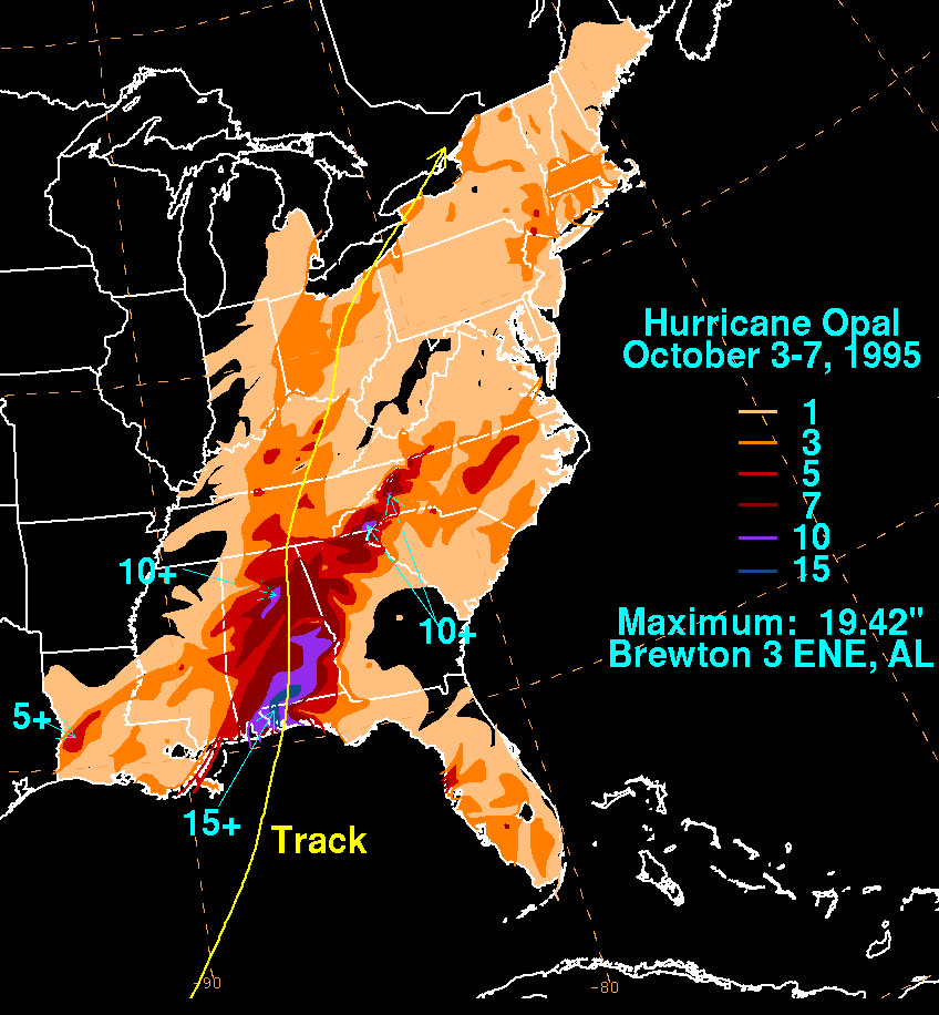
Rainfall totals from Opal across the eastern US as it raced inland to Ontario
Rainfall totals from Opal across the eastern US as it raced inland to Ontario NOAA / WPC

What policyholders learned

  • Surge follows peak strength, not landfall category. Opal's "weakened" Cat 3 label did not shrink the Cat 4 surge; owners who assumed wind-policy coverage for water damage met the flood exclusion.
  • Slab cases became causation fights. Where only a foundation remained, carriers presumed excluded surge; owners with pre-storm photos, elevation certificates, and wind-timing evidence recovered more.
  • Wind-pool coverage came with statewide strings. FWUA policyholders and every other Florida insured paid post-Opal assessments — pool coverage is real but its costs are socialized and its limits matter.
  • CCCL-era construction paid off in survival and in claims. Elevated, post-1975-code buildings both survived better and produced cleaner wind-versus-water claim files.
  • NFIP limits lag Gulf-front values. Flood policies capped at program limits left large uninsured gaps on high-value beachfront homes — a gap repeated in every Panhandle storm since.

Independent informational resource — not legal advice. Damage figures are nominal (not inflation-adjusted) unless noted. Insurance-law summaries are drafted for education; consult an attorney about your specific claim.

AT LANDFALL · HURRICANE OPAL · 1995
8-15 ft
OF STORM SURGE · PANHANDLE, NAVARRE BEACH AREA
HURRICANELAW.PRO FIELD FOOTAGE
03 THE FULL RECORD

Every official record of Opal

Reports, imagery archives, flood data, and claims records — straight from the agencies.

OUR LAW FIRM PARTNER · HALVERSEN LAW
Opal claim denied?
CALL FL941-390-3233CALL SC843-542-0454FREE CLAIM REVIEW
RELATED GUIDES
HurricaneLaw.Pro HURRICANELAW.PRO

The independent policyholder resource for Florida & South Carolina — storm archive, coverage law, denials, bad faith, and the complete claims playbook. 51 storms · 46 carriers · 97 public-adjuster firms · 37 city guides.

▸ SEE THE FULL SITE MAP — EVERY PAGE →
STORM ALERTS SOURCED FROM NOAA / NHC
SOUTH CAROLINA
496 Bramson Court, Suite 100
Mount Pleasant, SC 29464
CALL OR TEXT
FLORIDA
Tampa, FL
CALL OR TEXT
CLAIMS 9
DENIALS 8
BAD FAITH 7
COVERAGE 12
COMMERCIAL 8
ROOFS 8
TREES 5
DIRECTORIES
STORMS 51
WEATHER
NEWS & SITE 19
STORM ARCHIVE, CITIES & NEWS
Most recent below. Every storm dossier, city resource, and article is on its hub (linked at each heading) or the grouped site map →. All 46 carriers and 97 public-adjuster firms are in the Directories column above.
STORM ARCHIVE · 51 →
Hurricane Debby 2024Hurricane Helene 2024Hurricane Milton 2024Hurricane Idalia 2023Hurricane Ian 2022Hurricane Nicole 2022Hurricane Ida 2021Hurricane Laura 2020 View all 51 →
FLORIDA CITY RESOURCES · 29 →
Boca RatonBradentonCape CoralClearwaterDaytona BeachDestinFort LauderdaleFort Myers View all 29 →
SOUTH CAROLINA CITY RESOURCES · 8 →
BeaufortCharlestonColumbiaFlorenceGreenvilleHilton Head IslandMount PleasantMyrtle Beach
NEWS & UPDATES · 19 →

HurricaneLaw.Pro is an independent informational resource, not a law firm. Coverage summaries, policy-language quotations, dollar figures, deadlines, and chart examples throughout this site are general information based on typical or standard policy forms and are illustrative only — they are not a quote, a guarantee of coverage, or a promise of any outcome. Every insurance policy is different: your own policy, endorsements, and state law control, so read your policy and confirm current statutes. Weather imagery courtesy of NOAA, the National Hurricane Center, and the National Weather Service. Legal services are provided by our law firm partner, Halversen Law. Nothing on this site is legal advice; consult an attorney about your specific claim.

PrivacyTermsDisclaimerAboutContact
© 2026 HURRICANELAW.PRO — ALL RIGHTS RESERVED 27.9°N 82.5°W · ATLANTIC BASIN MONITOR
OUR LAW FIRM PARTNER
Halversen Law LICENSED · FLORIDA & SOUTH CAROLINA

All legal matters on this site are referred to and handled by our law firm partner, Halversen Law, a licensed law firm in Florida and South Carolina. HurricaneLaw.Pro is an informational resource and is not itself a law firm.

FREE CASE REVIEW