PROPERTY-INSURANCE CLAIM HELP · FL & SC FL CITIESSC CITIESGUIDESTATESNEWSSITE MAPABOUT
HurricaneLaw.Pro HURRICANELAW.PRO
Aftermath of the 1928 Okeechobee hurricane in South Florida
STORM ARCHIVE / 1928 LANDFALL 26.7°N 80.0°W
CAT 4 AT LANDFALL PEAK CAT 5 FL · 1928 · 160 mph

Okeechobee Hurricane

Landfall: West Palm Beach, FL · 1928-09-16. The lake dike failure that killed 2,500+ produced the Herbert Hoover Dike — federal flood control as the answer to an uninsurable peril, four decades before flood insurance existed

NOAA / NWS Miami
AT LANDFALL
CAT 4
PEAK INTENSITY
CAT 5 · 160 mph
PRESSURE
929 mb
STORM SURGE
Lake surge — floodwater to 20 ft deep
DAMAGE
~$25M FL (1928)
DEATHS
2,500+
01 THE PATH

Where it hit, start to finish

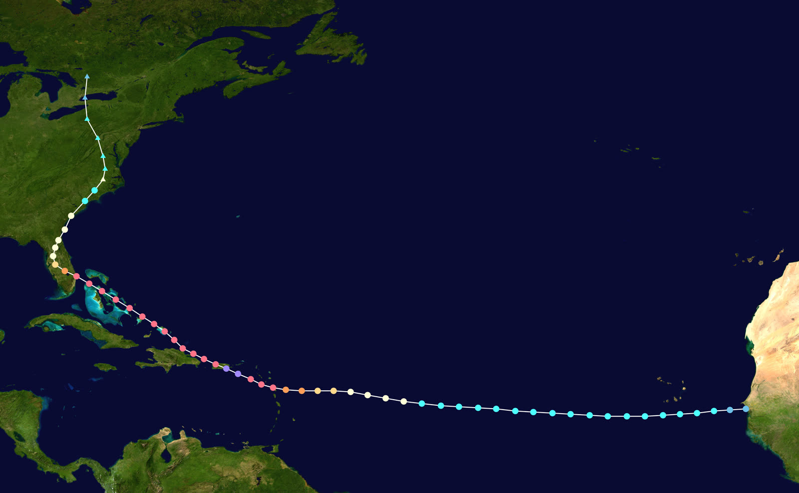
TRACK · OKEECHOBEE HURRICANENOAA / NHC (best-track data)
Best track of the 1928 Okeechobee hurricane, September 6–21, 1928
Puerto Rico
CATEGORY 5 — SAN FELIPE SEGUNDO

The hurricane struck Puerto Rico at Category 5 on September 13; 312 dead, 24,728 homes destroyed, 192,444 damaged — $50 million in losses before it ever reached Florida.

West Palm Beach, FL
CAT 4 LANDFALL — 929 MB

Landfall the evening of September 16 with ~145-mph winds. 1,711 homes destroyed in West Palm Beach; $13.8 million in damage in the city.

Belle Glade / South Bay / Pahokee
DIKE FAILURE — 2,500+ DEAD

Wind drove Lake Okeechobee over the low muck dike at its south end. Floodwater up to 20 ft deep swept farm communities into the Everglades; roughly 75% of the dead were Black migrant farmworkers, many never identified.

Port Mayaca / West Palm Beach
MASS GRAVES

1,600 victims were buried in a mass grave at Port Mayaca; 674 more in a segregated, unmarked grave in West Palm Beach that received a marker only decades later.

North Carolina / Ontario
DISSIPATION

The storm curved north over Florida, became extratropical over North Carolina on September 19, and dissipated over Ontario September 21.

02 THE RECORD IN IMAGES
ALL IMAGERY U.S. GOV / PUBLIC DOMAIN
DAMAGE State Archives of Florida (Florida Memory)
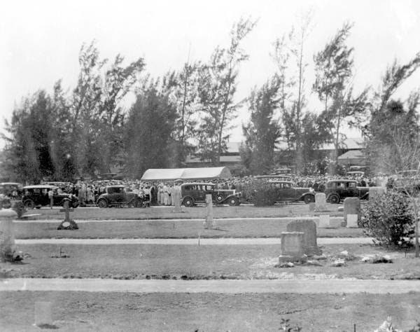
Burial of victims in West Palm Beach; 674 Black victims were interred in an unmarked mass grave
FLOOD Wikimedia Commons (public domain)
Extent of the Lake Okeechobee flood after the dike failure — hundreds of square miles inundated
MAP NOAA Central Library (U.S. Weather Bureau)
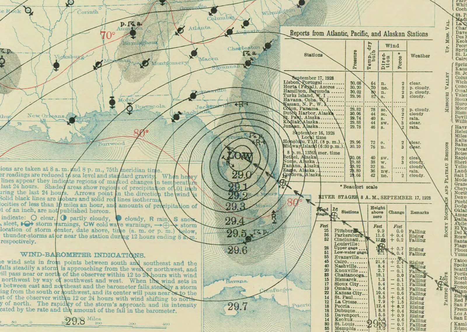
U.S. Weather Bureau surface map at Florida landfall, September 17, 1928
DAMAGE Public domain (Wikimedia Commons montage)
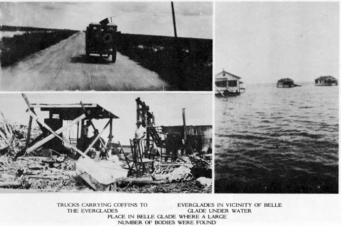
Scenes of flooding and wreckage around Lake Okeechobee's south shore

The storm

The hurricane formed off West Africa near Dakar on September 6, 1928 — a classic Cape Verde storm — and crossed the Atlantic on a nearly straight west-northwest line. It struck Guadeloupe on September 12, then hit Puerto Rico at Category 5 strength on September 13 with winds estimated near 160 mph, the storm Puerto Rico still calls San Felipe Segundo.

Florida landfall came near West Palm Beach on the evening of September 16 at Category 4, pressure 929 mb, winds around 145 mph. The center tracked directly over Lake Okeechobee. On the lake's south shore, farm towns — Belle Glade, South Bay, Pahokee — sat behind a muck dike five to eight feet high, built to hold back irrigation water, not a hurricane. Northerly winds piled the shallow lake against it. The dike failed.

Floodwater spread over hundreds of square miles, more than 20 feet deep in places. The storm curved north across Florida, went extratropical over North Carolina on September 19, and dissipated over Ontario two days later.

Extent of the Lake Okeechobee flood after the dike failure — hundreds of square miles inundated
Extent of the Lake Okeechobee flood after the dike failure — hundreds of square miles inundated Wikimedia Commons (public domain)

The damage

The official U.S. death toll stands at 2,500+ — the second-deadliest hurricane in U.S. history, behind only Galveston 1900. Roughly 75% of the dead were Black migrant farmworkers; many bodies washed into the Everglades and were never recovered, and identification was so poor the true toll is unknowable. West Palm Beach lost 1,711 homes. Florida property damage ran about $25 million in 1928 dollars; Puerto Rico's toll added $50 million, 312 dead, and nearly 25,000 homes destroyed.

The burials became their own scar: 1,600 victims in a mass grave at Port Mayaca, and 674 Black victims in a segregated, unmarked mass grave at Tamarind Avenue in West Palm Beach — unrecognized until modern times.

U.S. Weather Bureau surface map at Florida landfall, September 17, 1928
U.S. Weather Bureau surface map at Florida landfall, September 17, 1928 NOAA Central Library (U.S. Weather Bureau)

The insurance aftermath

Almost none of this loss touched an insurance company. The dead and displaced were overwhelmingly tenant farmworkers and smallholders in wooden housing — no fire policies, no windstorm endorsements, and no flood product existed anywhere in the market. Relief was the only payout system: 3,390 American Red Cross workers, nearly $5.9 million in donated funds, and food, clothing, and building-material distribution to hundreds of thousands of families across Florida and Puerto Rico.

What the storm changed was the government's role in an uninsurable peril. President-elect Herbert Hoover toured the flood zone within weeks and, in office, put the Army Corps of Engineers on the problem. Florida created the Okeechobee Flood Control District in 1929 to cost-share with the Corps. The River and Harbor Act of 1930 authorized 67.8 miles of levee on the lake's south shore and 15.7 miles on the north — the earthwork that grew into the Herbert Hoover Dike. State building codes were tightened in the same wave.

The pattern set in 1928 — catastrophic flood loss answered by federal engineering rather than private insurance — held for 40 years, through the 1947 floods and the Central & Southern Florida Project, until Congress finally created the National Flood Insurance Program in 1968. Today the Hoover Dike itself is the exposure: a dike breach is the modeled worst case behind Glades-area flood zones, and it began here.
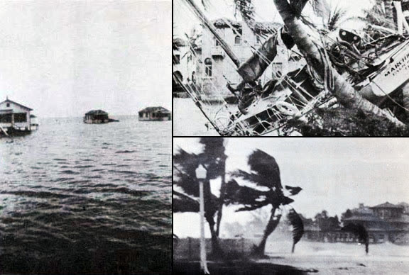
Scenes of flooding and wreckage around Lake Okeechobee's south shore
Scenes of flooding and wreckage around Lake Okeechobee's south shore Public domain (Wikimedia Commons montage)

What policyholders learned

  • Flood was, and is, the uninsured peril. In 1928 no flood coverage existed; today it exists but must be bought separately, before the storm. The households behind a levee or dike are exactly the ones who skip it.
  • Relief is not indemnity. Red Cross aid rebuilt subsistence, not property values. Modern FEMA grants are the same instrument — capped assistance, not replacement cost.
  • Undocumented losses vanish. Victims without records could not be identified, let alone compensated. An inventory, deeds, and photographs are what make a loss provable — then and now.
  • Engineering moves risk; it does not remove it. The dike ended recurring lake floods and simultaneously concentrated a low-frequency catastrophic one. Living behind flood control is a reason to carry flood insurance, not to drop it.
  • The poorest policyholders bear denial hardest. The 1928 dead were the workers with no paper protection at all — the founding case for pairing coverage access with disaster policy.

Independent informational resource — not legal advice. Damage figures are nominal (not inflation-adjusted) unless noted. Insurance-law summaries are drafted for education; consult an attorney about your specific claim.

AT LANDFALL · OKEECHOBEE HURRICANE · 1928
Lake surge — floodwater to 20 ft deep
OF STORM SURGE · BELLE GLADE / SOUTH BAY
HURRICANELAW.PRO FIELD FOOTAGE
03 THE FULL RECORD

Every official record of Okeechobee Hurricane

Reports, imagery archives, flood data, and claims records — straight from the agencies.

OUR LAW FIRM PARTNER · HALVERSEN LAW
Okeechobee Hurricane claim denied?
CALL FL941-390-3233CALL SC843-542-0454FREE CLAIM REVIEW
RELATED GUIDES
HurricaneLaw.Pro HURRICANELAW.PRO

The independent policyholder resource for Florida & South Carolina — storm archive, coverage law, denials, bad faith, and the complete claims playbook. 51 storms · 46 carriers · 97 public-adjuster firms · 37 city guides.

▸ SEE THE FULL SITE MAP — EVERY PAGE →
STORM ALERTS SOURCED FROM NOAA / NHC
SOUTH CAROLINA
496 Bramson Court, Suite 100
Mount Pleasant, SC 29464
CALL OR TEXT
FLORIDA
Tampa, FL
CALL OR TEXT
CLAIMS 9
DENIALS 8
BAD FAITH 7
COVERAGE 12
COMMERCIAL 8
ROOFS 8
TREES 5
DIRECTORIES
STORMS 51
WEATHER
NEWS & SITE 19
STORM ARCHIVE, CITIES & NEWS
Most recent below. Every storm dossier, city resource, and article is on its hub (linked at each heading) or the grouped site map →. All 46 carriers and 97 public-adjuster firms are in the Directories column above.
STORM ARCHIVE · 51 →
Hurricane Debby 2024Hurricane Helene 2024Hurricane Milton 2024Hurricane Idalia 2023Hurricane Ian 2022Hurricane Nicole 2022Hurricane Ida 2021Hurricane Laura 2020 View all 51 →
FLORIDA CITY RESOURCES · 29 →
Boca RatonBradentonCape CoralClearwaterDaytona BeachDestinFort LauderdaleFort Myers View all 29 →
SOUTH CAROLINA CITY RESOURCES · 8 →
BeaufortCharlestonColumbiaFlorenceGreenvilleHilton Head IslandMount PleasantMyrtle Beach
NEWS & UPDATES · 19 →

HurricaneLaw.Pro is an independent informational resource, not a law firm. Coverage summaries, policy-language quotations, dollar figures, deadlines, and chart examples throughout this site are general information based on typical or standard policy forms and are illustrative only — they are not a quote, a guarantee of coverage, or a promise of any outcome. Every insurance policy is different: your own policy, endorsements, and state law control, so read your policy and confirm current statutes. Weather imagery courtesy of NOAA, the National Hurricane Center, and the National Weather Service. Legal services are provided by our law firm partner, Halversen Law. Nothing on this site is legal advice; consult an attorney about your specific claim.

PrivacyTermsDisclaimerAboutContact
© 2026 HURRICANELAW.PRO — ALL RIGHTS RESERVED 27.9°N 82.5°W · ATLANTIC BASIN MONITOR
OUR LAW FIRM PARTNER
Halversen Law LICENSED · FLORIDA & SOUTH CAROLINA

All legal matters on this site are referred to and handled by our law firm partner, Halversen Law, a licensed law firm in Florida and South Carolina. HurricaneLaw.Pro is an informational resource and is not itself a law firm.

FREE CASE REVIEW