
PROPERTY-INSURANCE CLAIM HELP · FL & SC FL CITIESSC CITIESGUIDESTATESNEWSSITE MAPABOUT
HurricaneLaw.Pro HURRICANELAW.PRO
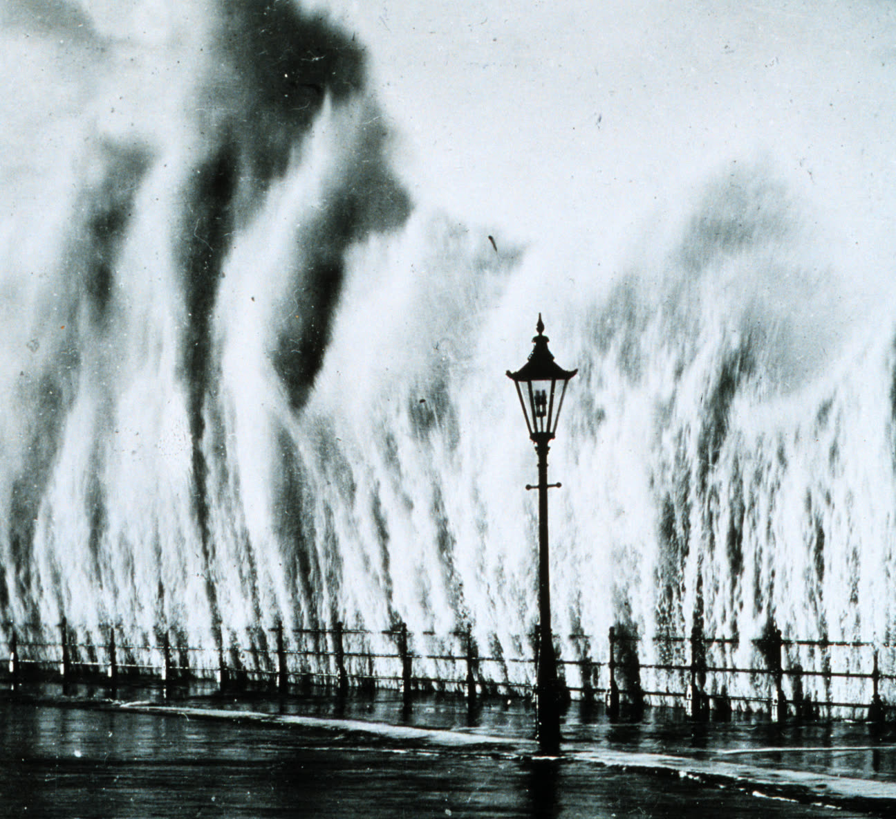
Storm surge from the September 21, 1938 hurricane breaking over the New England shore
STORM ARCHIVE / 1938 LANDFALL 40.7°N 72.9°W
CAT 3 AT LANDFALL PEAK CAT 5 US · 1938 · 160 mph

New England Hurricane

Landfall: Bellport, Long Island, NY; second landfall near Milford, CT · 1938-09-21. Windstorm coverage was so rare in 1938 that the storm drove mass adoption of the new extended-coverage endorsement — the ancestor of modern wind coverage — and it remains the return-period benchmark for Northeast catastrophe models

NOAA Photo Library
AT LANDFALL
CAT 3
PEAK INTENSITY
CAT 5 · 160 mph
PRESSURE
941 mb
STORM SURGE
12-15 ft
DAMAGE
~$306M
DEATHS
682+
01 THE PATH

Where it hit, start to finish

TRACK · NEW ENGLAND HURRICANENOAA (HURDAT best-track data)
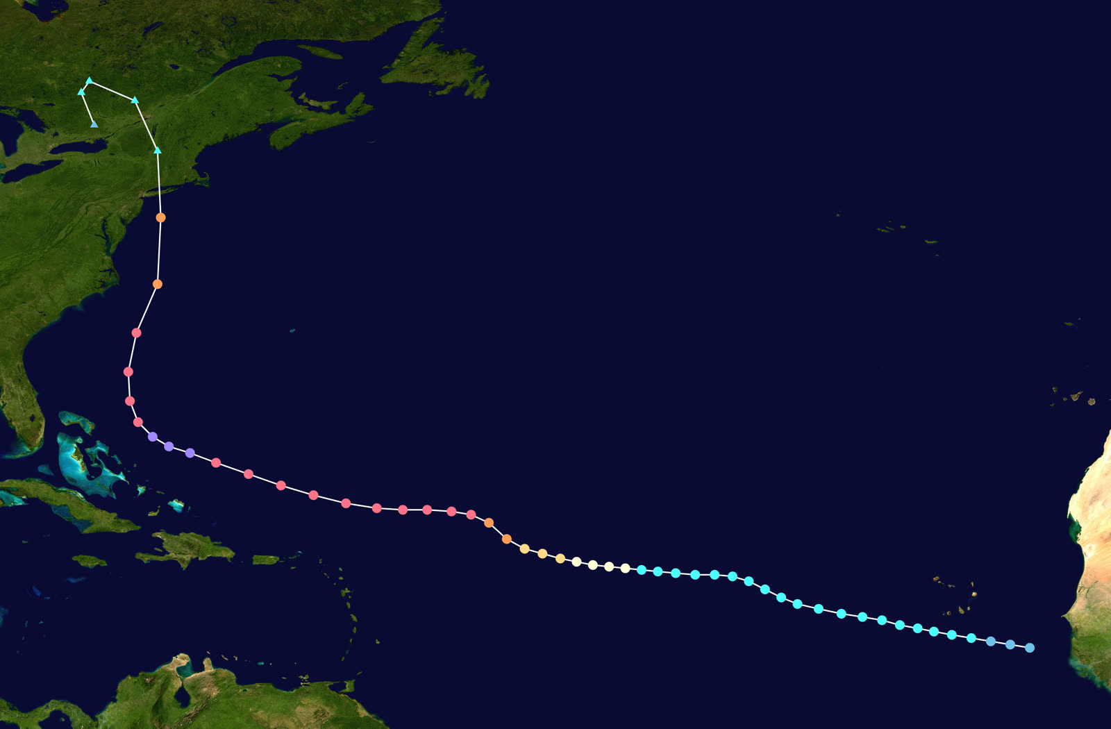
Best track of the 1938 New England hurricane — a Cape Verde storm that raced north at up to 47 mph
Cape Verde / open Atlantic
PEAK CAT 5 - 160 MPH

A classic Cape Verde hurricane, first tracked September 9, peaking near 160 mph east of the Bahamas. Forecasters expected a recurve out to sea; no hurricane warnings were posted north of New Jersey.

Offshore Mid-Atlantic
THE EXPRESS - 47+ MPH FORWARD SPEED

Trapped between a trough and the Bermuda high, the storm accelerated to a forward speed near 47 mph — reaching Long Island roughly 12 hours after passing Cape Hatteras, faster than warnings could catch up.

Bellport, Long Island, NY
FIRST LANDFALL - CAT 3

Landfall mid-afternoon September 21 with winds near 120 mph, at high tide of the autumnal equinox. Downing, Westhampton, and Fire Island communities were swept; at Westhampton Beach, 29 died.

Milford, CT / New Haven
SECOND LANDFALL

The eye crossed Long Island Sound in about an hour. Surge and river flooding inundated Connecticut shore towns; New London's waterfront burned while flooded.

Napatree Point / Providence, RI
RHODE ISLAND SURGE - 682+ DEAD REGIONWIDE

Surge of 12-15 feet swept the Rhode Island shore east of the eye. All 39 houses at Napatree Point were carried away. Downtown Providence flooded to 13 feet at rush hour. Rhode Island counted more than 400 of the storm's 682+ deaths.

Interior New England
WIND AND FOREST LOSS TO CANADA

Blue Hill Observatory (MA) measured 121 mph sustained winds with a 186 mph gust. An estimated 2 billion trees fell across New York and New England before the storm crossed into Canada that night.

02 THE RECORD IN IMAGES
ALL IMAGERY U.S. GOV / PUBLIC DOMAIN
DAMAGE NOAA Photo Library (NOS/NGS)
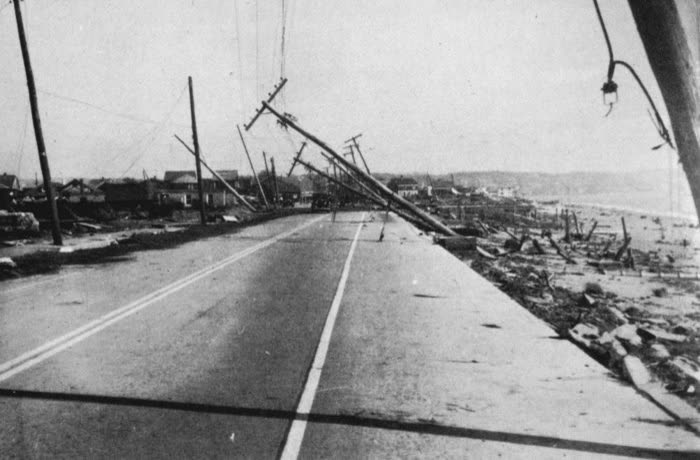
Coastal wreckage after the hurricane — some 8,900 homes and buildings were destroyed across the region
AERIAL U.S. Army Air Corps
Army Air Corps aerial of Ocean Beach, Fire Island, NY, stripped by the surge
DAMAGE Library of Congress (FSA/OWI)
Hurricane wreckage documented by the Farm Security Administration, 1938
SURGE Kenneth C. Zirkel (CC0)
High-water marks at the Old Market House, Providence — the 1938 line sits above the 1815 mark
MAP NOAA / WPC (David Roth)
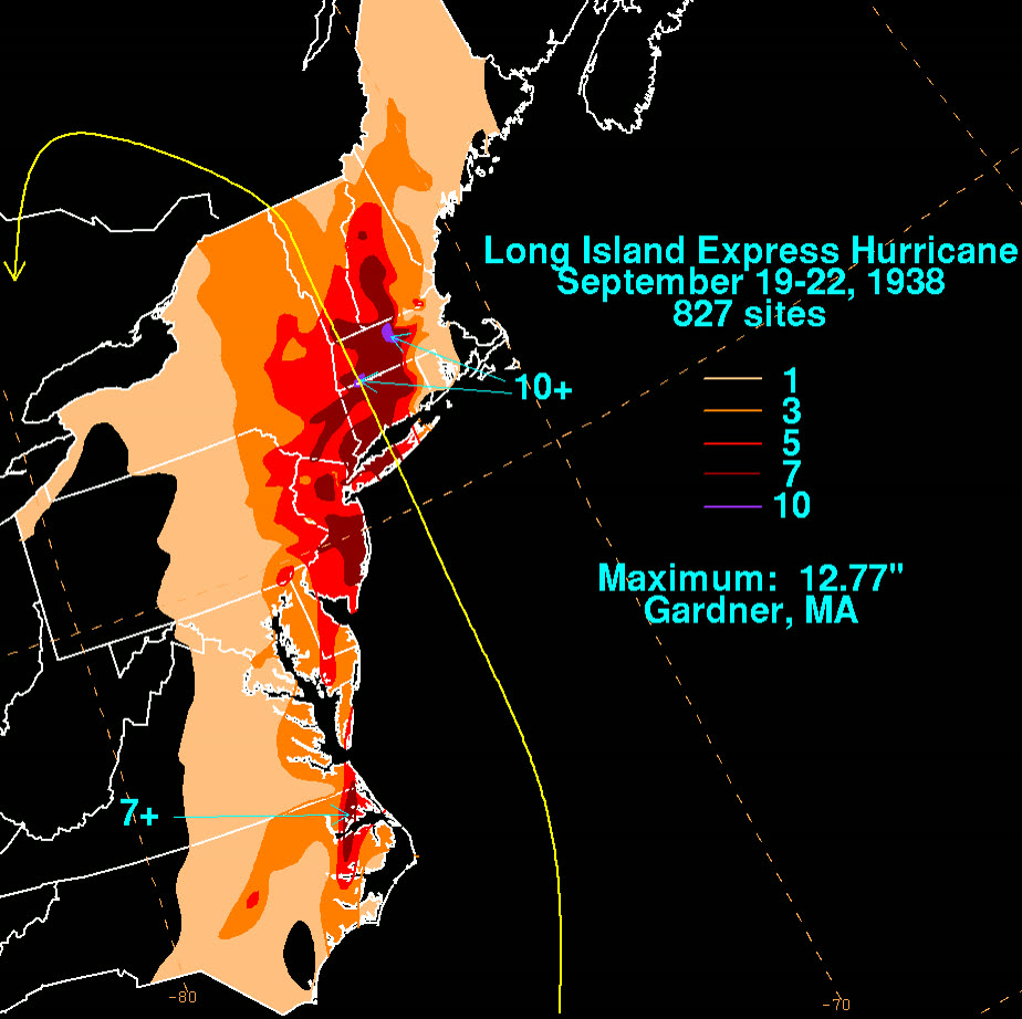
Rainfall footprint of the Long Island Express — up to 10+ inches on ground already saturated by days of rain

The storm

The 1938 New England hurricane — the "Long Island Express" — was a Cape Verde storm first tracked September 9. It peaked near 160 mph east of the Bahamas. The Weather Bureau expected it to recurve out to sea, and no hurricane warnings were posted north of New Jersey. A junior forecaster who argued the storm would run up the coast was overruled.

Caught between an approaching trough and the Bermuda high, the hurricane accelerated to a forward speed near 47 mph. It covered the distance from Cape Hatteras to Long Island in about 12 hours, striking Bellport, Long Island, mid-afternoon on September 21, 1938, as a Category 3 with roughly 120 mph sustained winds and a 941 mb pressure — at the high tide of the autumnal equinox. A second landfall near Milford, Connecticut, followed within the hour.

New England had not taken a major hurricane in over a century. It got surge of 12-15 feet on the Rhode Island shore, 121 mph sustained winds with a 186 mph gust at Blue Hill Observatory, and 10+ inches of rain on ground already saturated. At least 682 people died. Damage reached about $306 million in 1938 dollars.
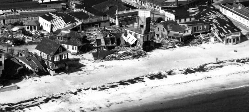
Army Air Corps aerial of Ocean Beach, Fire Island, NY, stripped by the surge
Army Air Corps aerial of Ocean Beach, Fire Island, NY, stripped by the surge U.S. Army Air Corps

The damage

The surge did the killing. All 39 houses at Napatree Point, Rhode Island, were swept into the bay. Westhampton Beach on Long Island lost 150 of 179 waterfront homes; 29 people died there. Downtown Providence went under 13 feet of water at evening rush hour — the high-water mark at the Old Market House sits above the 1815 hurricane's line. Rhode Island alone counted more than 400 dead.

The wind footprint ran to Canada. Roughly 8,900 homes and buildings were destroyed and more than 15,000 damaged. An estimated 2 billion trees came down across New York and New England, along with 26,000 automobiles crushed or drowned and 20,000 miles of power and phone lines. New London, Connecticut, flooded and then burned.
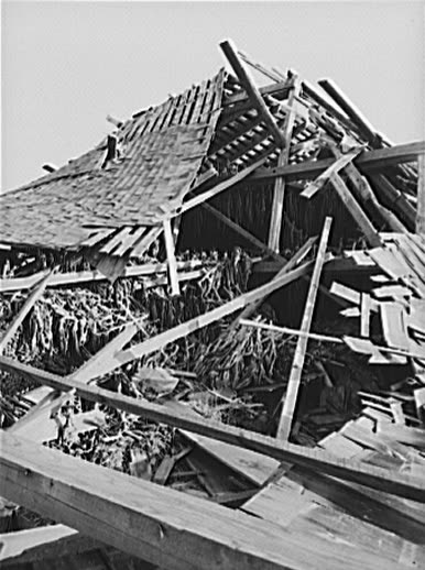
Hurricane wreckage documented by the Farm Security Administration, 1938
Hurricane wreckage documented by the Farm Security Administration, 1938 Library of Congress (FSA/OWI)

The insurance aftermath

In 1938 most Northeastern property owners carried fire policies with no wind protection at all. Windstorm coverage existed as the "Additional Hazards Supplemental Contract," renamed the Extended Coverage endorsement earlier that same year — but in the East it was viewed as a luxury and rarely purchased. Little of it had been sold in Massachusetts before the storm. So while total damage ran about $306 million, only a modest fraction was insured; most surge and wind losses fell on owners.

The market response was immediate and structural. In October 1938 — the month after landfall — the New England Insurance Exchange revised the Extended Coverage endorsement to cover all types of windstorms, not just tornadoes, plus hail and vehicle damage. Purchases of the endorsement surged across New England after the storm. That endorsement is the direct ancestor of the windstorm peril in every modern homeowners policy: the 1938 hurricane is the event that made wind coverage a standard purchase rather than a specialty rider.

The storm's second insurance legacy arrived decades later. Because it is the benchmark major hurricane for the most valuable coastline in the country, "1938 repeat" is a standard return-period scenario in catastrophe models used to price Northeast wind risk and reinsurance. Modern loss estimates for a repeat run into the tens of billions of dollars — a number that shapes coastal premiums from New Jersey to Maine, and one reason regulators and rating agencies stress-test Northeast carriers against a storm from 1938.
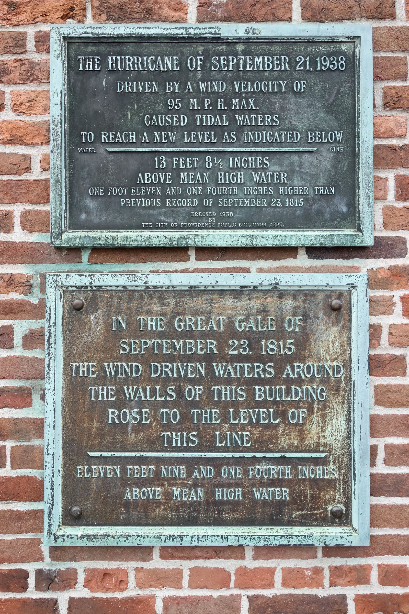
High-water marks at the Old Market House, Providence — the 1938 line sits above the 1815 mark
High-water marks at the Old Market House, Providence — the 1938 line sits above the 1815 mark Kenneth C. Zirkel (CC0)

What policyholders learned

  • The peril you skipped is the one that finds you. New England hadn't seen a major hurricane in a century, wind coverage seemed optional, and a one-day storm produced a region of uninsured totals. Low-frequency is not no-frequency.
  • Surge losses fell outside even the new wind endorsement. Wind coverage responded to wind; the tidal wave that erased Napatree Point was excluded water damage — the same wind/water line policyholders still litigate.
  • High-water marks are evidence. The surveyed 1938 water lines in Providence and along Narragansett Bay settled arguments about what was wind versus water, and still inform flood mapping today.
  • Post-storm reforms follow the loss data. The endorsement was broadened within weeks because the losses were documented and undeniable. Policyholders who documented thoroughly were part of the record that changed the product.
  • Catastrophe pricing has a memory. Northeast wind premiums still carry 1938 in their math. A storm can leave the claims system and never leave the rate filing.

Independent informational resource — not legal advice. Damage figures are nominal (not inflation-adjusted) unless noted. Insurance-law summaries are drafted for education; consult an attorney about your specific claim.

AT LANDFALL · NEW ENGLAND HURRICANE · 1938
12-15 ft; downtown Providence flooded to 13 ft
OF STORM SURGE · RI COAST
HURRICANELAW.PRO FIELD FOOTAGE
03 THE FULL RECORD

Every official record of New England Hurricane

Reports, imagery archives, flood data, and claims records — straight from the agencies.

OUR LAW FIRM PARTNER · HALVERSEN LAW
New England Hurricane claim denied?
CALL FL941-390-3233CALL SC843-542-0454FREE CLAIM REVIEW
RELATED GUIDES
HurricaneLaw.Pro HURRICANELAW.PRO

The independent policyholder resource for Florida & South Carolina — storm archive, coverage law, denials, bad faith, and the complete claims playbook. 51 storms · 46 carriers · 97 public-adjuster firms · 37 city guides.

▸ SEE THE FULL SITE MAP — EVERY PAGE →
STORM ALERTS SOURCED FROM NOAA / NHC
SOUTH CAROLINA
496 Bramson Court, Suite 100
Mount Pleasant, SC 29464
CALL OR TEXT
FLORIDA
Tampa, FL
CALL OR TEXT
CLAIMS 9
DENIALS 8
BAD FAITH 7
COVERAGE 12
COMMERCIAL 8
ROOFS 8
TREES 5
DIRECTORIES
STORMS 51
WEATHER
NEWS & SITE 19
STORM ARCHIVE, CITIES & NEWS
Most recent below. Every storm dossier, city resource, and article is on its hub (linked at each heading) or the grouped site map →. All 46 carriers and 97 public-adjuster firms are in the Directories column above.
STORM ARCHIVE · 51 →
Hurricane Debby 2024Hurricane Helene 2024Hurricane Milton 2024Hurricane Idalia 2023Hurricane Ian 2022Hurricane Nicole 2022Hurricane Ida 2021Hurricane Laura 2020 View all 51 →
FLORIDA CITY RESOURCES · 29 →
Boca RatonBradentonCape CoralClearwaterDaytona BeachDestinFort LauderdaleFort Myers View all 29 →
SOUTH CAROLINA CITY RESOURCES · 8 →
BeaufortCharlestonColumbiaFlorenceGreenvilleHilton Head IslandMount PleasantMyrtle Beach
NEWS & UPDATES · 19 →

HurricaneLaw.Pro is an independent informational resource, not a law firm. Coverage summaries, policy-language quotations, dollar figures, deadlines, and chart examples throughout this site are general information based on typical or standard policy forms and are illustrative only — they are not a quote, a guarantee of coverage, or a promise of any outcome. Every insurance policy is different: your own policy, endorsements, and state law control, so read your policy and confirm current statutes. Weather imagery courtesy of NOAA, the National Hurricane Center, and the National Weather Service. Legal services are provided by our law firm partner, Halversen Law. Nothing on this site is legal advice; consult an attorney about your specific claim.

PrivacyTermsDisclaimerAboutContact
© 2026 HURRICANELAW.PRO — ALL RIGHTS RESERVED 27.9°N 82.5°W · ATLANTIC BASIN MONITOR
OUR LAW FIRM PARTNER
Halversen Law LICENSED · FLORIDA & SOUTH CAROLINA

All legal matters on this site are referred to and handled by our law firm partner, Halversen Law, a licensed law firm in Florida and South Carolina. HurricaneLaw.Pro is an informational resource and is not itself a law firm.

FREE CASE REVIEW