PROPERTY-INSURANCE CLAIM HELP · FL & SC FL CITIESSC CITIESGUIDESTATESNEWSSITE MAPABOUT
HurricaneLaw.Pro HURRICANELAW.PRO
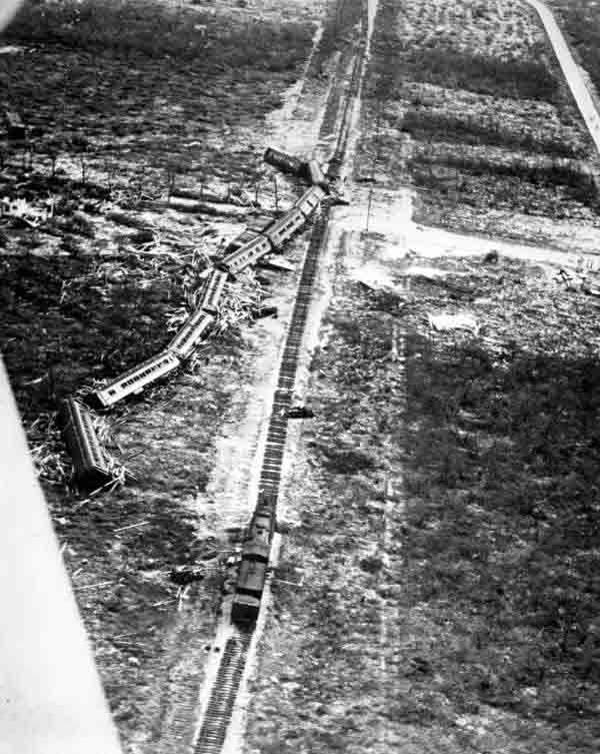
The eleven-car rescue train swept off the tracks at Islamorada by the 18-foot surge, September 2, 1935
STORM ARCHIVE / 1935 LANDFALL 24.8°N 80.8°W
CAT 5 FL · 1935 · 185 mph

Labor Day Hurricane

Landfall: Upper Florida Keys (Long Key / Islamorada) · 1935-09-02. Still the most intense U.S. landfall ever recorded — 892 mb; the dead were federal relief workers, and compensation came from Congress, not carriers

Public domain (Florida archival photo)
AT LANDFALL
CAT 5
PEAK WIND
185 mph
PRESSURE
892 mb
STORM SURGE
18–20 ft
DAMAGE
~$6M (1935)
DEATHS
408+
01 THE PATH

Where it hit, start to finish

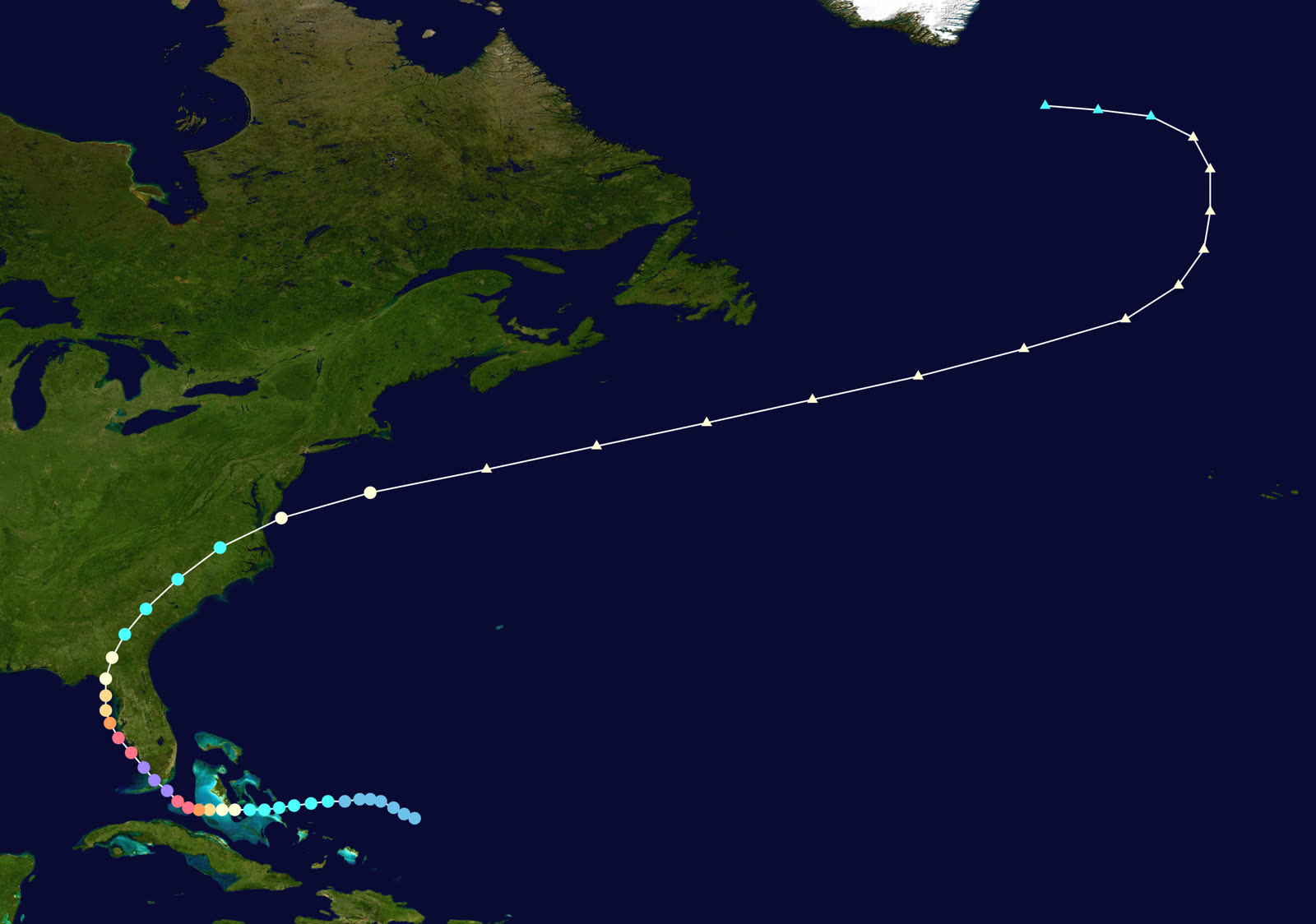
TRACK · LABOR DAY HURRICANENOAA / NHC (best-track data)
Best track of the Labor Day hurricane, August 29 – September 10, 1935
East of the Bahamas
RAPID INTENSIFICATION

First tracked August 29 near the Bahamas as a small tropical storm, it intensified explosively in the Florida Straits — from hurricane to Category 5 in roughly two days, with an eye only a few miles wide.

Long Key / Islamorada
892 MB — STRONGEST U.S. LANDFALL EVER

Landfall on Labor Day evening, September 2, with winds estimated at 185 mph and pressure of 892 mb — still the lowest ever measured at a U.S. landfall. Surge of 18–20 ft swept the islands bare.

Upper Matecumbe Key
RESCUE TRAIN SWEPT AWAY

The evacuation train sent from Miami for 400+ veterans in three federal work camps reached Islamorada at 8:20 p.m. — as the surge arrived. Every car but the locomotive was washed off the tracks.

Florida Keys
408+ DEAD

The Florida relief administration counted 423 dead by that November — about 260 of them World War I veterans employed on the Overseas Highway project; later accounting reached 485. Islamorada was effectively obliterated.

Cedar Key / Big Bend
SECOND LANDFALL

The storm recurved up the Gulf and struck near Cedar Key on September 4 as a Category 2, then weakened over the Southeast and merged with an extratropical system by September 10.

02 THE RECORD IN IMAGES
ALL IMAGERY U.S. GOV / PUBLIC DOMAIN
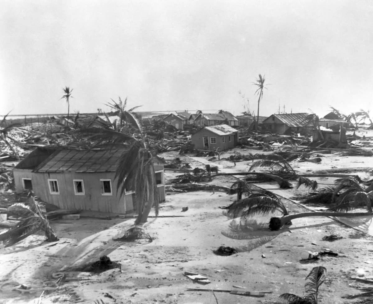
DAMAGE Public domain (1935 press photo)
Wreckage of homes in the upper Keys; whole settlements on Upper and Lower Matecumbe were leveled
MAP NOAA Central Library (U.S. Weather Bureau)
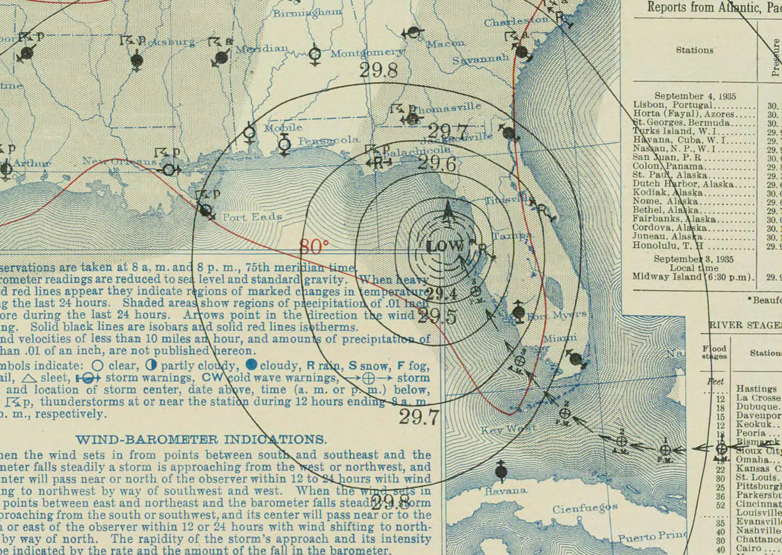
U.S. Weather Bureau surface map, September 3, 1935 — the morning after the Keys landfall
MAP NOAA Central Library (U.S. Weather Bureau)
Surface map September 4, 1935, as the storm moved up the Gulf toward a second landfall at Cedar Key

The storm

The Labor Day hurricane was first tracked on August 29, 1935, as a small, unremarkable storm near the Bahamas. In the Florida Straits it intensified faster than any forecaster of the era thought possible, reaching Category 5 with a tiny, violent core.

It struck the upper Keys near Long Key on the evening of Monday, September 2 — Labor Day — with winds estimated at 185 mph and a central pressure of 892 mb, still the lowest ever recorded at a United States landfall. Storm surge of 18 to 20 feet crossed islands that stand three to eight feet above sea level. The hurricane then ran up Florida's Gulf coast, made a second landfall near Cedar Key on September 4 as a Category 2, and faded over the Southeast, merging with an extratropical system by September 10.
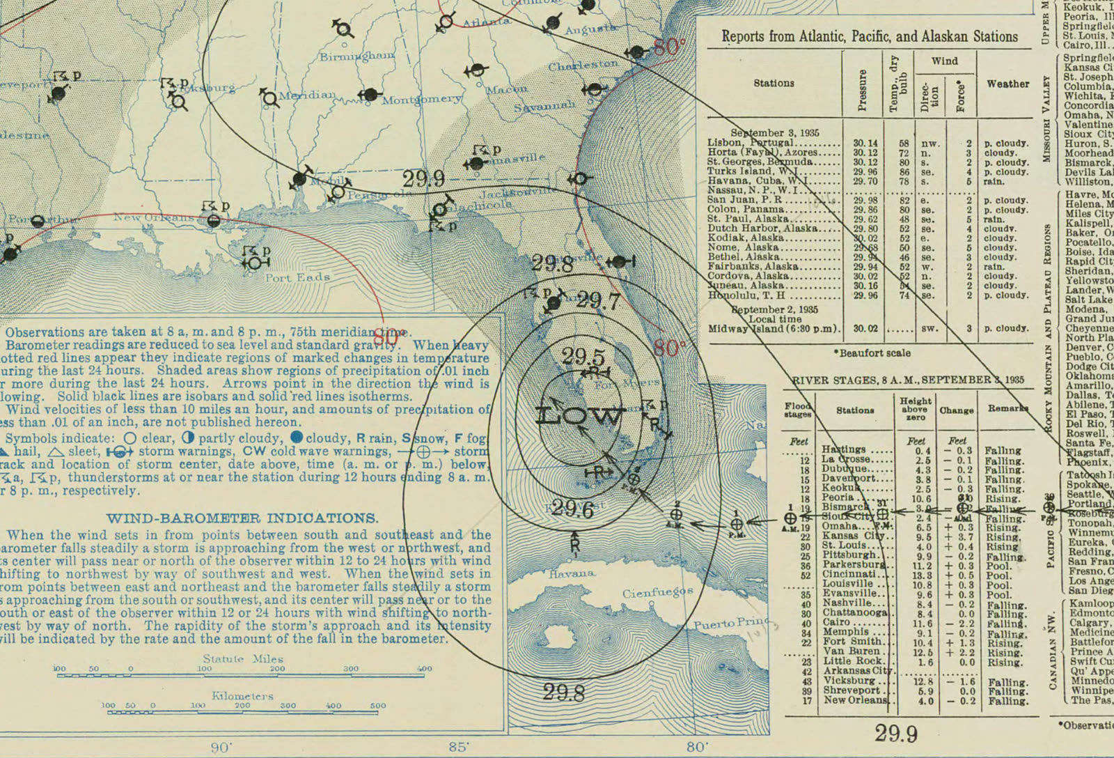
U.S. Weather Bureau surface map, September 3, 1935 — the morning after the Keys landfall
U.S. Weather Bureau surface map, September 3, 1935 — the morning after the Keys landfall NOAA Central Library (U.S. Weather Bureau)

The damage

Everything in the core's path went. Islamorada was nearly obliterated; between Tavernier and Marathon, settlements, packing houses, and the veterans' work camps were flattened or swept into Florida Bay. The Florida East Coast Railway's Overseas Railroad — Flagler's "eighth wonder" — lost 40 miles of track and embankment and never ran again.

The human toll centered on three federal work camps housing 695 men, most of them World War I veterans of the Bonus Army era, employed by the Federal Emergency Relief Administration (FERA) to build the Overseas Highway. The evacuation train sent from Miami arrived at Islamorada at 8:20 p.m., as the surge did; ten of its eleven cars were swept off the rails. Florida's relief administration counted 423 dead that November — about 260 veterans and 164 civilians — a figure that grew to 485 by 1936. Property damage was about $6 million in 1935 dollars: small in money, total in kind.

Surface map September 4, 1935, as the storm moved up the Gulf toward a second landfall at Cedar Key
Surface map September 4, 1935, as the storm moved up the Gulf toward a second landfall at Cedar Key NOAA Central Library (U.S. Weather Bureau)

The insurance aftermath

There was almost no insurance in this story — which is the story. The Keys dead were federal relief workers in government camps; the destroyed homes were conch settlements without policies. So the compensation fight went to Washington instead of a claims office. FERA director Harry Hopkins denied negligence and blamed Weather Bureau warnings; investigator David Kennamer's two-volume report cited negligence by three Florida relief officials and was suppressed for decades; the American Legion's report called it "murder at Matacombe," and Ernest Hemingway's "Who Killed the Vets?" made the scandal national. Congress held hearings in 1936 on H.R. 9486 to compensate widows and survivors — a legislative claims process standing in for the insurance the victims never had.

The corporate loss ran through a bankruptcy, not a policy. The FEC Railway had been in receivership since 1931; the storm converted a marginal line into a total write-off. The railroad abandoned the route, and the right-of-way and bridges were sold to the State of Florida, which opened the Overseas Highway to Key West in 1938 on the railbed the veterans had been building beside.

The meteorological record became an underwriting fixture: 892 mb defines the U.S. intensity ceiling, and Keys wind-loss models still use the 1935 storm as the benchmark scenario. The 1937 Islamorada memorial, holding cremated remains of hundreds of victims, marks the event Florida building and evacuation policy in the Keys is measured against.
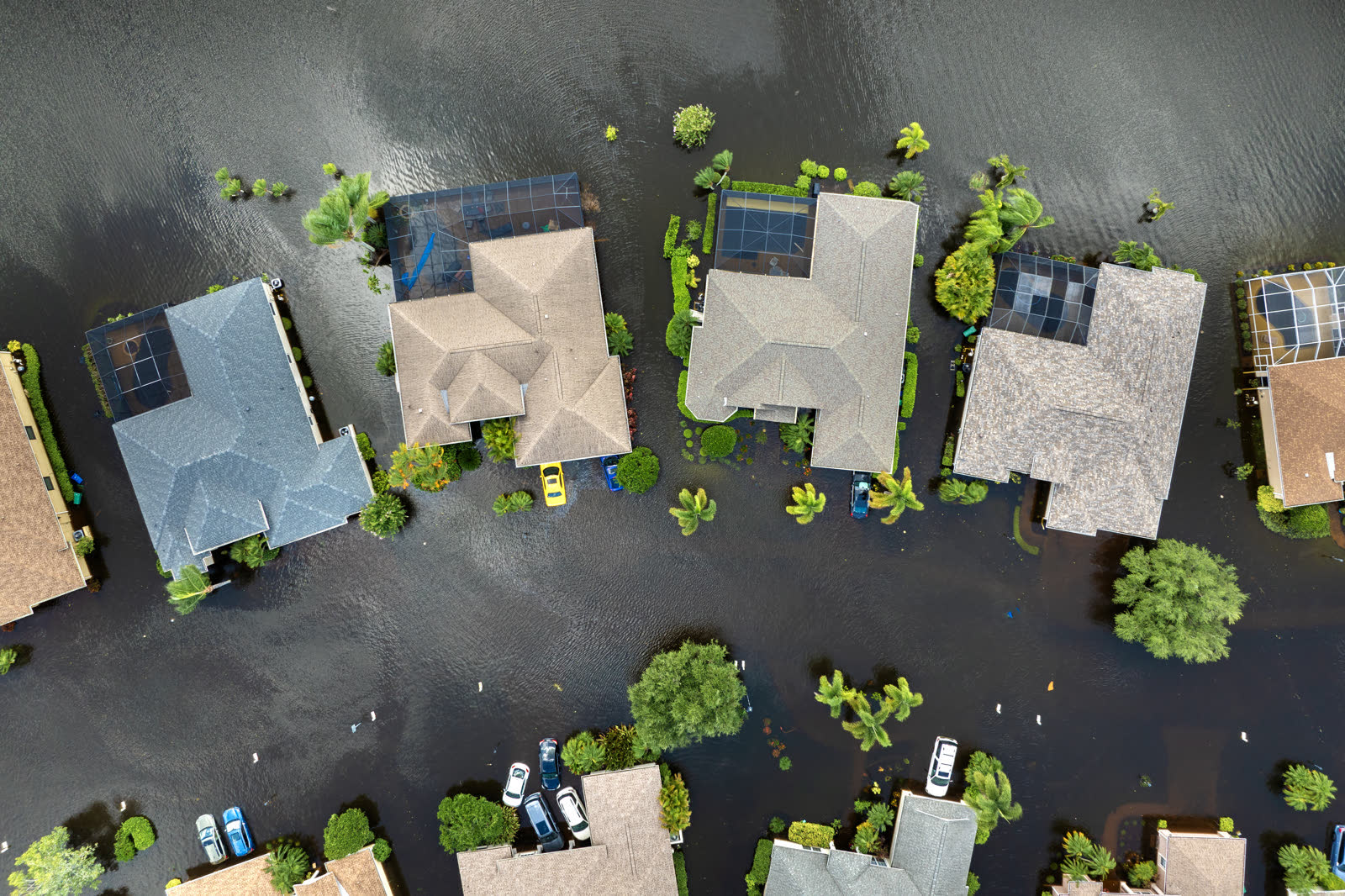
Tropical-storm flooding, Florida
Tropical-storm flooding, Florida HURRICANELAW.PRO FIELD FOOTAGE

What policyholders learned

  • Evacuation timing is a claims issue, too. The train left hours late and 400+ people died. Modern parallel: late preparation destroys both lives and the documentation that supports claims — records stored in the risk zone are lost with the property.
  • Government compensation is slow and political. Survivors waited on congressional hearings, investigations, and a suppressed report. Insurance, where it exists, pays on contract terms — not on a vote.
  • Small damage totals can hide total losses. $6 million in 1935 dollars represented 100% destruction of everything in the path. Percentage-of-value losses, not headline totals, are what a policy has to cover.
  • Employer and government housing does not mean covered property. Workers in the camps owned what they carried. Renters and workers housed on-site still need their own contents coverage.
  • Extreme-intensity records drive today's premiums. The 892-mb benchmark anchors probable-maximum-loss models for the Keys; owners there pay for 1935 in every rate filing.

Independent informational resource — not legal advice. Damage figures are nominal (not inflation-adjusted) unless noted. Insurance-law summaries are drafted for education; consult an attorney about your specific claim.

AT LANDFALL · LABOR DAY HURRICANE · 1935
18–20 ft
OF STORM SURGE · UPPER MATECUMBE KEY
HURRICANELAW.PRO FIELD FOOTAGE
03 THE FULL RECORD

Every official record of Labor Day Hurricane

Reports, imagery archives, flood data, and claims records — straight from the agencies.

OUR LAW FIRM PARTNER · HALVERSEN LAW
Labor Day Hurricane claim denied?
CALL FL941-390-3233CALL SC843-542-0454FREE CLAIM REVIEW
RELATED GUIDES
HurricaneLaw.Pro HURRICANELAW.PRO

The independent policyholder resource for Florida & South Carolina — storm archive, coverage law, denials, bad faith, and the complete claims playbook. 51 storms · 46 carriers · 97 public-adjuster firms · 37 city guides.

▸ SEE THE FULL SITE MAP — EVERY PAGE →
STORM ALERTS SOURCED FROM NOAA / NHC
SOUTH CAROLINA
496 Bramson Court, Suite 100
Mount Pleasant, SC 29464
CALL OR TEXT
FLORIDA
Tampa, FL
CALL OR TEXT
CLAIMS 9
DENIALS 8
BAD FAITH 7
COVERAGE 12
COMMERCIAL 8
ROOFS 8
TREES 5
DIRECTORIES
STORMS 51
WEATHER
NEWS & SITE 19
STORM ARCHIVE, CITIES & NEWS
Most recent below. Every storm dossier, city resource, and article is on its hub (linked at each heading) or the grouped site map →. All 46 carriers and 97 public-adjuster firms are in the Directories column above.
STORM ARCHIVE · 51 →
Hurricane Debby 2024Hurricane Helene 2024Hurricane Milton 2024Hurricane Idalia 2023Hurricane Ian 2022Hurricane Nicole 2022Hurricane Ida 2021Hurricane Laura 2020 View all 51 →
FLORIDA CITY RESOURCES · 29 →
Boca RatonBradentonCape CoralClearwaterDaytona BeachDestinFort LauderdaleFort Myers View all 29 →
SOUTH CAROLINA CITY RESOURCES · 8 →
BeaufortCharlestonColumbiaFlorenceGreenvilleHilton Head IslandMount PleasantMyrtle Beach
NEWS & UPDATES · 19 →

HurricaneLaw.Pro is an independent informational resource, not a law firm. Coverage summaries, policy-language quotations, dollar figures, deadlines, and chart examples throughout this site are general information based on typical or standard policy forms and are illustrative only — they are not a quote, a guarantee of coverage, or a promise of any outcome. Every insurance policy is different: your own policy, endorsements, and state law control, so read your policy and confirm current statutes. Weather imagery courtesy of NOAA, the National Hurricane Center, and the National Weather Service. Legal services are provided by our law firm partner, Halversen Law. Nothing on this site is legal advice; consult an attorney about your specific claim.

PrivacyTermsDisclaimerAboutContact
© 2026 HURRICANELAW.PRO — ALL RIGHTS RESERVED 27.9°N 82.5°W · ATLANTIC BASIN MONITOR
OUR LAW FIRM PARTNER
Halversen Law LICENSED · FLORIDA & SOUTH CAROLINA

All legal matters on this site are referred to and handled by our law firm partner, Halversen Law, a licensed law firm in Florida and South Carolina. HurricaneLaw.Pro is an informational resource and is not itself a law firm.

FREE CASE REVIEW