
PROPERTY-INSURANCE CLAIM HELP · FL & SC FL CITIESSC CITIESGUIDESTATESNEWSSITE MAPABOUT
HurricaneLaw.Pro HURRICANELAW.PRO
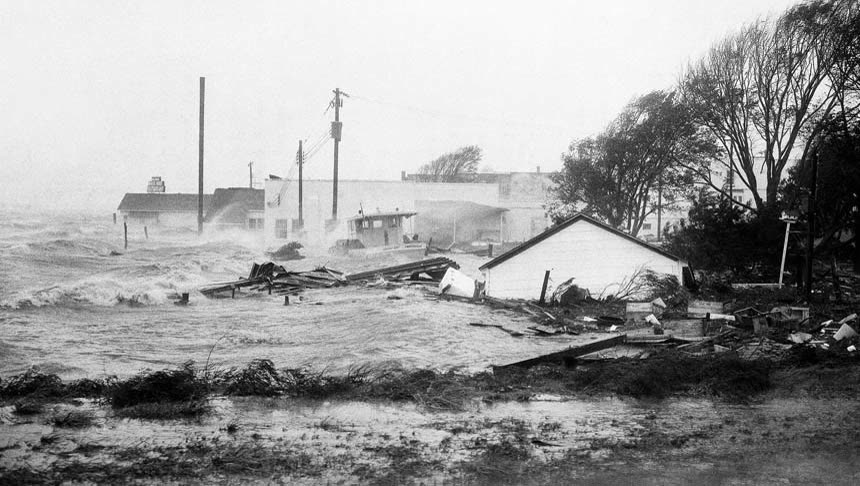
Hazel's storm surge pours through Morehead City, North Carolina, October 15, 1954
STORM ARCHIVE / 1954 LANDFALL 33.9°N 78.5°W
CAT 4 SC · 1954 · 130 mph

Hurricane Hazel

Landfall: NC/SC state line at Little River Inlet · 1954-10-15. 80% of Myrtle Beach's waterfront dwellings were destroyed on the year's highest lunar tide — 14 years before federal flood insurance existed

NOAA / NWS
AT LANDFALL
CAT 4
PEAK WIND
130 mph
PRESSURE
938 mb
STORM SURGE
up to 18 ft
DAMAGE
$281M US
DEATHS
95 US
01 THE PATH

Where it hit, start to finish

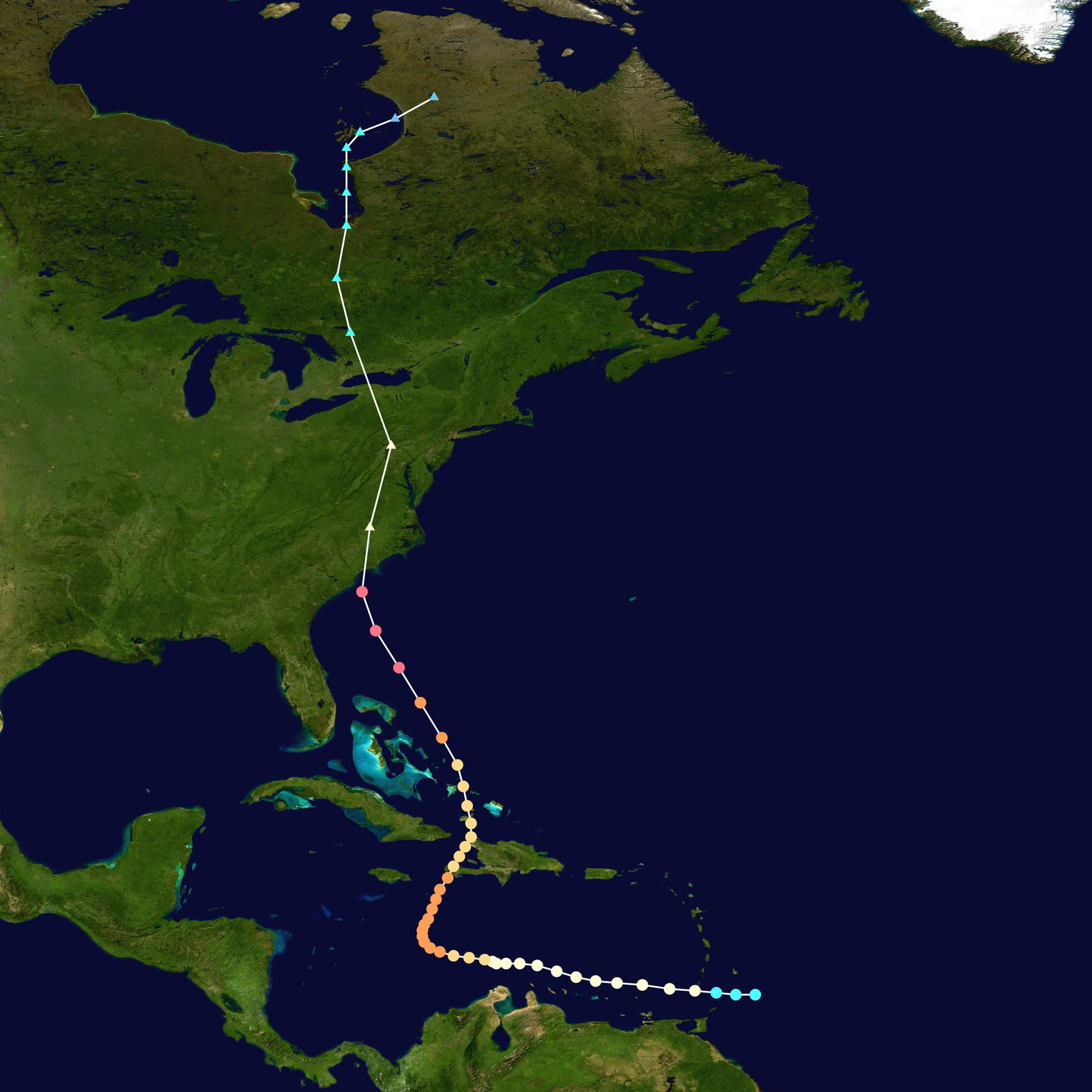
TRACK · HURRICANE HAZELNOAA / NHC (best-track data)
Best track and Saffir-Simpson intensity of Hurricane Hazel, October 5-18, 1954
Haiti
400-1,000 DEAD IN THE CARIBBEAN

Hazel crossed Haiti on October 12 as a Category 3, killing 400-1,000 people and destroying 40% of the coffee crop before recurving north toward the Carolinas.

Little River Inlet, NC/SC line
CAT 4 LANDFALL - 130 MPH

Landfall the morning of October 15, 1954 with winds near 130 mph and 938 mb pressure — on the highest lunar tide of the year. Surge reached up to 18 feet near Calabash.

Myrtle Beach, SC
80% OF WATERFRONT DWELLINGS DESTROYED

Hundreds of buildings destroyed along the Grand Strand. About 80% of Myrtle Beach's oceanfront dwellings were leveled; at Pawleys Island 40 homes were destroyed outright.

Long Beach / Brunswick County, NC
352 OF 357 BUILDINGS GONE

Just east of the eye, Long Beach was nearly erased — only five of 357 buildings survived. North Carolina counted 19 dead, 15,000 homes destroyed, and 39,000 damaged.

Raleigh to Washington, DC
HURRICANE-FORCE WIND FAR INLAND

Racing north at more than 50 mph, Hazel carried hurricane-force gusts through central North Carolina, Virginia, and the mid-Atlantic; Washington, DC recorded its strongest gusts on record at the time.

Toronto, Canada
81 DEAD IN ONTARIO

Merging with a cold front, Hazel dumped flooding rain on Toronto the same night. The Humber River swept away a full block of Raymore Drive, killing 35 of Canada's 81 dead. Hazel's name was retired.

02 THE RECORD IN IMAGES
ALL IMAGERY U.S. GOV / PUBLIC DOMAIN
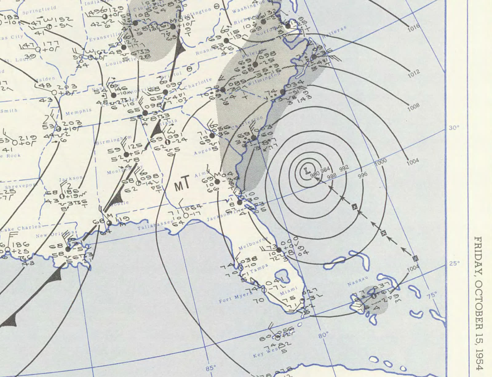
MAP NOAA Central Library / U.S. Weather Bureau
U.S. Weather Bureau surface analysis as Hazel struck the NC/SC line at Category 4, October 15, 1954
MAP NOAA Central Library / U.S. Weather Bureau
Surface map of Hazel approaching Haiti, October 11 — the storm killed 400-1,000 there before turning north
MAP NOAA / WPC
Rainfall footprint of Hazel from the Carolinas to Ontario — it was still doing damage in Toronto 12 hours after landfall

The storm

Hazel formed east of Grenada on October 5, 1954, crossed Haiti as a Category 3 on October 12 — killing 400 to 1,000 people — then turned north and accelerated toward the Carolinas. On the morning of October 15 it made landfall at the North Carolina/South Carolina line near Little River Inlet as a Category 4, with sustained winds estimated at 130 mph and a central pressure of 938 mb.

Timing multiplied the damage: landfall coincided with the highest lunar tide of the year. Surge ran 10 to 11 feet along the Grand Strand and up to 18 feet near Calabash, just east of the state line, with waves on top of it.

Hazel then did something few hurricanes have matched. Racing north-northeast at over 50 mph, it carried hurricane-force gusts through Raleigh, Virginia, and Washington, DC, and reached Toronto the same night — where its rains killed 81 people in Ontario, 35 of them on a single flooded street. Total U.S. toll: 95 dead and $281 million in damage, the costliest and deadliest U.S. storm of the brutal 1954 season.
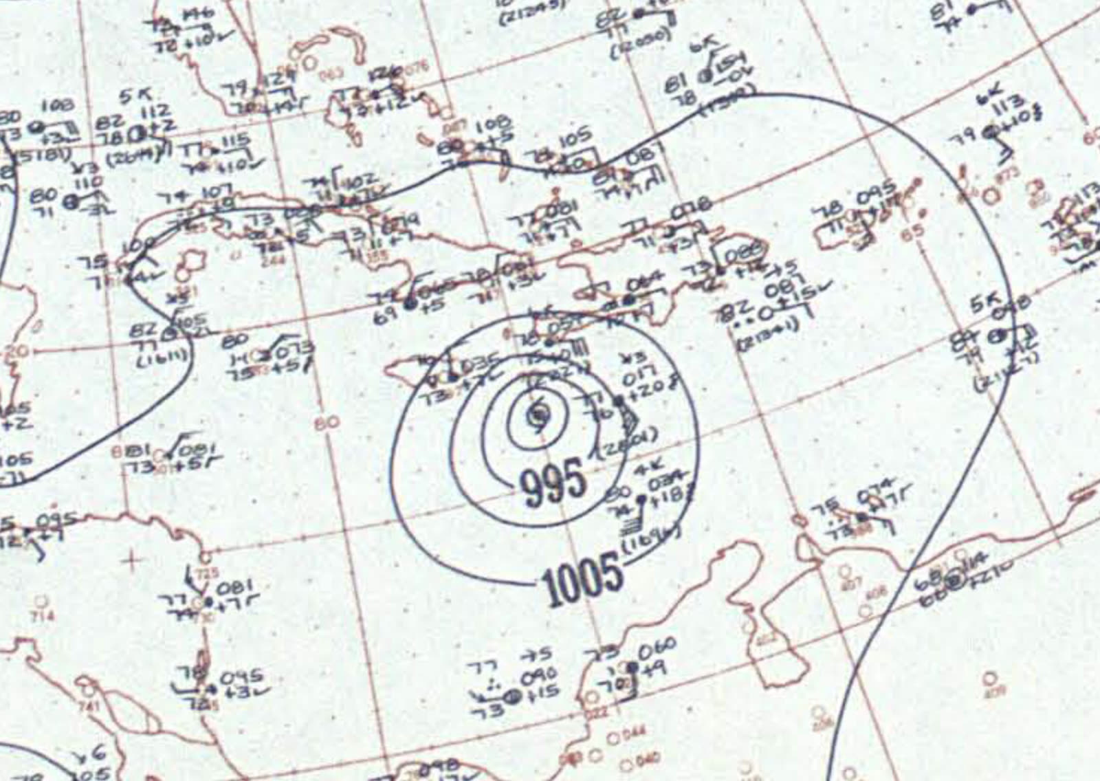
Surface map of Hazel approaching Haiti, October 11 — the storm killed 400-1,000 there before turning north
Surface map of Hazel approaching Haiti, October 11 — the storm killed 400-1,000 there before turning north NOAA Central Library / U.S. Weather Bureau

The damage

The South Carolina oceanfront from Pawleys Island to Little River took the storm's left-front quadrant at high tide. About 80% of the waterfront dwellings in Myrtle Beach were destroyed. Pawleys Island lost 40 homes outright. Garden City and Cherry Grove were swept nearly flat. The pre-Hazel Grand Strand — small wooden beach cottages set close to the dunes — effectively ceased to exist in one morning.

Across the line in Brunswick County, NC, the destruction was near-total: at Long Beach, five of 357 buildings were left standing. North Carolina counted 19 dead, 15,000 homes destroyed, and another 39,000 damaged.

Wind damage extended hundreds of miles inland — downed trees and roofs through the Piedmont, record gusts in the mid-Atlantic — before the Toronto flood disaster ended the storm's run.
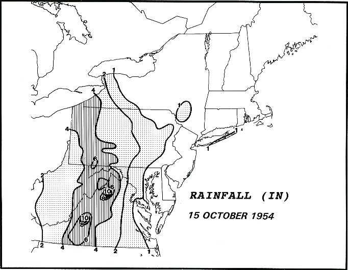
Rainfall footprint of Hazel from the Carolinas to Ontario — it was still doing damage in Toronto 12 hours after landfall
Rainfall footprint of Hazel from the Carolinas to Ontario — it was still doing damage in Toronto 12 hours after landfall NOAA / WPC

The insurance aftermath

Hazel hit an insurance market with no answer for coastal water damage. There was no NFIP (created 1968), no SC Wind and Hail Underwriting Association (created 1971), and no FEMA (1979). Standard fire and extended-coverage policies of 1954 covered wind but not "tidal wave" or rising water — so the surge that removed most of the Myrtle Beach oceanfront was, for most owners, simply an uninsured loss. President Eisenhower's "major disaster" declaration for the Carolinas on October 17 unlocked only modest federal help by modern standards; recovery capital was savings, bank credit, and Red Cross relief.

The 1954-55 season — Carol, Edna, and Hazel in one year, then Connie, Diane, and Ione the next — is what pushed catastrophe onto the national policy agenda. Congressional hearings on flood disaster insurance began in 1955 and produced the Federal Flood Insurance Act of 1956, the direct legislative ancestor of the NFIP. Insurers, for their part, absorbed the wind losses but hardened their position that flood and surge were uninsurable by the private market — the coverage line that still splits every coastal claim today.

On the Grand Strand the aftermath was a rebuilding boom. Cheap wrecked oceanfront land changed hands, and the small-cottage beach was replaced over the following decade by larger motels and commercial strips — the modern Myrtle Beach. Local histories credit Hazel with reshaping building practices and coastal construction standards across the region, decades before statewide wind-zone codes.
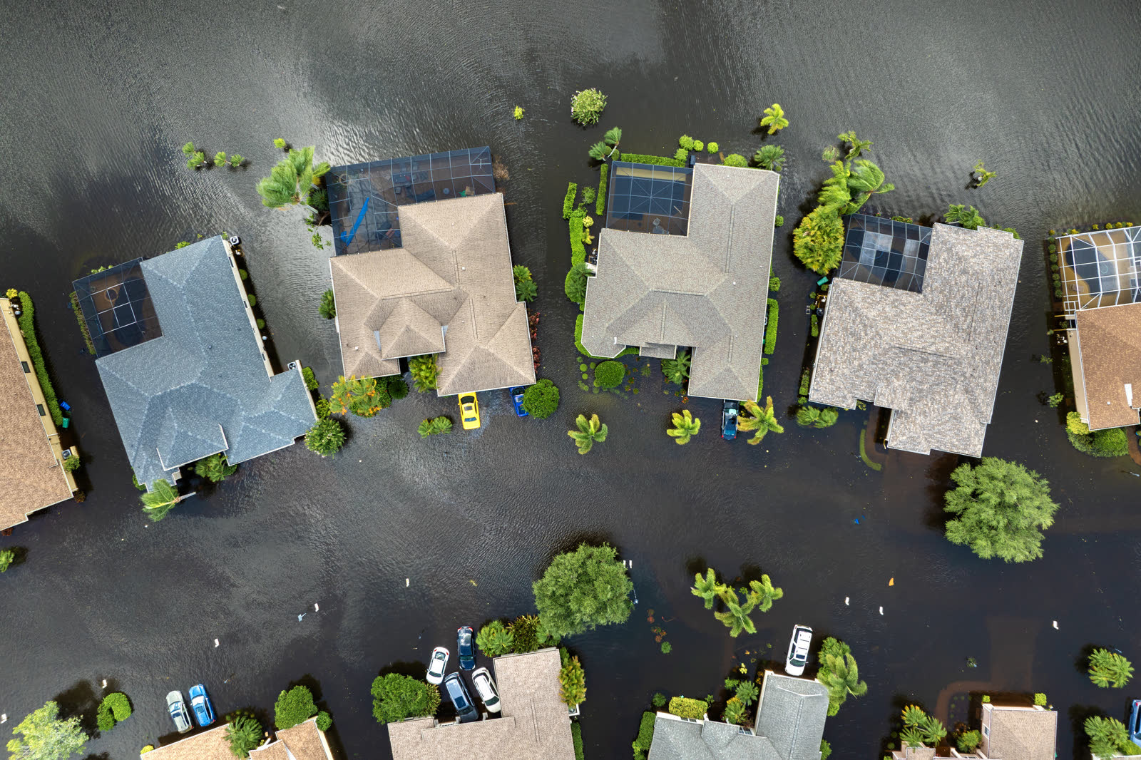
Tropical-storm flooding, Florida
Tropical-storm flooding, Florida HURRICANELAW.PRO FIELD FOOTAGE

What policyholders learned

  • The wind/water line predates the NFIP. Hazel-era policies paid for wind-torn roofs but not surge-swept foundations. That exclusion never left; it moved into the NFIP era intact and still decides Grand Strand claims.
  • Storms compound with tides. Hazel's surge on the year's highest lunar tide is why identical storms produce different losses. Elevation and tide timing — not category alone — set water damage.
  • Total-loss neighborhoods leave no comparables. With 80% of a waterfront gone, valuation disputes followed; owners with pre-storm photographs, deeds, and inventories settled fastest — the earliest version of today's documentation advice.
  • Rebuilding without codes rebuilt the risk. Post-Hazel reconstruction went up fast and mostly unregulated; much of it was destroyed again by Hugo in 1989. Stronger rebuilding standards protect both safety and future insurability.
  • One season can move national policy. Hazel plus the 1955 storms produced the first federal flood-insurance legislation within two years — the pattern (catastrophe, then reform) that repeats through Betsy, Camille, Andrew, and Katrina.

Independent informational resource — not legal advice. Damage figures are nominal (not inflation-adjusted) unless noted. Insurance-law summaries are drafted for education; consult an attorney about your specific claim.

AT LANDFALL · HURRICANE HAZEL · 1954
up to 18 ft
OF STORM SURGE · CALABASH / LITTLE RIVER AREA
HURRICANELAW.PRO FIELD FOOTAGE
03 THE FULL RECORD

Every official record of Hazel

Reports, imagery archives, flood data, and claims records — straight from the agencies.

OUR LAW FIRM PARTNER · HALVERSEN LAW
Hazel claim denied?
CALL FL941-390-3233CALL SC843-542-0454FREE CLAIM REVIEW
RELATED GUIDES
HurricaneLaw.Pro HURRICANELAW.PRO

The independent policyholder resource for Florida & South Carolina — storm archive, coverage law, denials, bad faith, and the complete claims playbook. 51 storms · 46 carriers · 97 public-adjuster firms · 37 city guides.

▸ SEE THE FULL SITE MAP — EVERY PAGE →
STORM ALERTS SOURCED FROM NOAA / NHC
SOUTH CAROLINA
496 Bramson Court, Suite 100
Mount Pleasant, SC 29464
CALL OR TEXT
FLORIDA
Tampa, FL
CALL OR TEXT
CLAIMS 9
DENIALS 8
BAD FAITH 7
COVERAGE 12
COMMERCIAL 8
ROOFS 8
TREES 5
DIRECTORIES
STORMS 51
WEATHER
NEWS & SITE 19
STORM ARCHIVE, CITIES & NEWS
Most recent below. Every storm dossier, city resource, and article is on its hub (linked at each heading) or the grouped site map →. All 46 carriers and 97 public-adjuster firms are in the Directories column above.
STORM ARCHIVE · 51 →
Hurricane Debby 2024Hurricane Helene 2024Hurricane Milton 2024Hurricane Idalia 2023Hurricane Ian 2022Hurricane Nicole 2022Hurricane Ida 2021Hurricane Laura 2020 View all 51 →
FLORIDA CITY RESOURCES · 29 →
Boca RatonBradentonCape CoralClearwaterDaytona BeachDestinFort LauderdaleFort Myers View all 29 →
SOUTH CAROLINA CITY RESOURCES · 8 →
BeaufortCharlestonColumbiaFlorenceGreenvilleHilton Head IslandMount PleasantMyrtle Beach
NEWS & UPDATES · 19 →

HurricaneLaw.Pro is an independent informational resource, not a law firm. Coverage summaries, policy-language quotations, dollar figures, deadlines, and chart examples throughout this site are general information based on typical or standard policy forms and are illustrative only — they are not a quote, a guarantee of coverage, or a promise of any outcome. Every insurance policy is different: your own policy, endorsements, and state law control, so read your policy and confirm current statutes. Weather imagery courtesy of NOAA, the National Hurricane Center, and the National Weather Service. Legal services are provided by our law firm partner, Halversen Law. Nothing on this site is legal advice; consult an attorney about your specific claim.

PrivacyTermsDisclaimerAboutContact
© 2026 HURRICANELAW.PRO — ALL RIGHTS RESERVED 27.9°N 82.5°W · ATLANTIC BASIN MONITOR
OUR LAW FIRM PARTNER
Halversen Law LICENSED · FLORIDA & SOUTH CAROLINA

All legal matters on this site are referred to and handled by our law firm partner, Halversen Law, a licensed law firm in Florida and South Carolina. HurricaneLaw.Pro is an informational resource and is not itself a law firm.

FREE CASE REVIEW