
PROPERTY-INSURANCE CLAIM HELP · FL & SC FL CITIESSC CITIESGUIDESTATESNEWSSITE MAPABOUT
HurricaneLaw.Pro HURRICANELAW.PRO
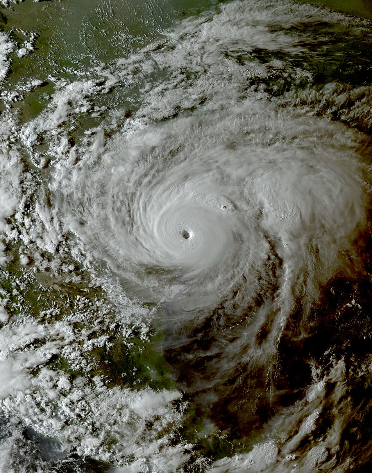
Harvey at Category 4 intensity making landfall on the Texas Coastal Bend, evening of August 25, 2017
STORM ARCHIVE / 2017 LANDFALL 28.0°N 96.8°W
CAT 4 US · 2017 · 130 mph

Hurricane Harvey

Landfall: San Jose Island / Rockport, TX · 2017-08-25. Roughly 80% of flooded Harris County homes had no flood insurance — and 63% of Harvey homeowners claims closed without payment

NOAA / NESDIS (GOES-16)
AT LANDFALL
CAT 4
PEAK WIND
130 mph
PRESSURE
937 mb
STORM SURGE
6-10 ft
DAMAGE
$125B
DEATHS
68 direct
01 THE PATH

Where it hit, start to finish

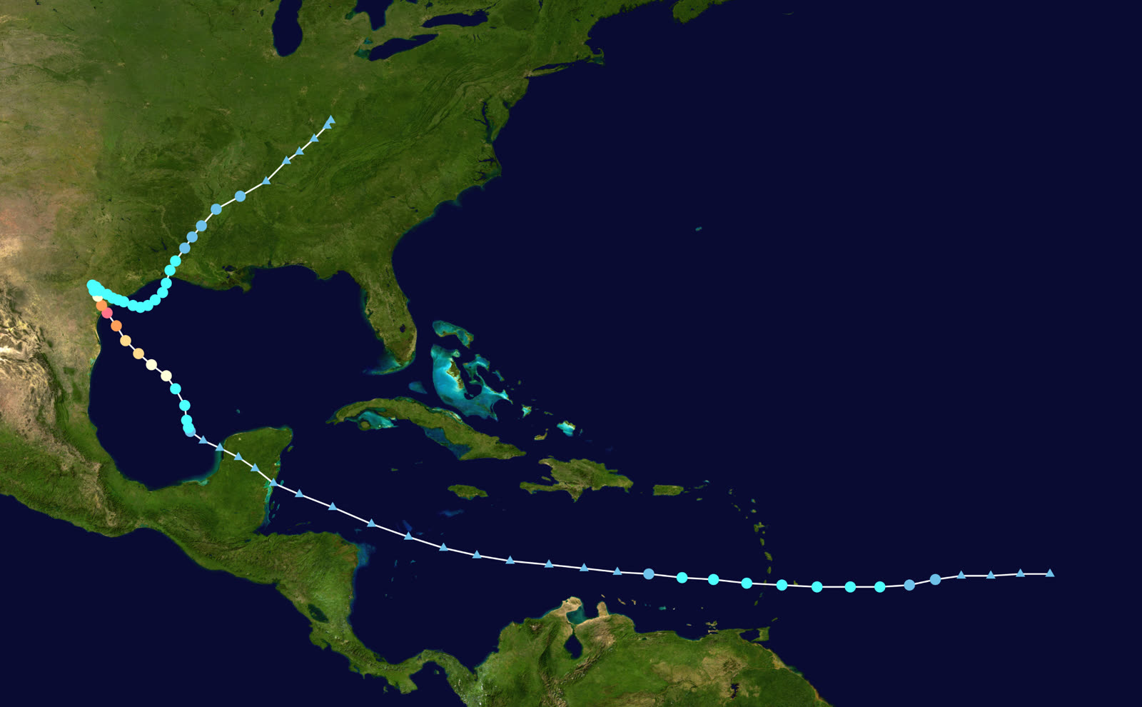
TRACK · HURRICANE HARVEYNOAA / NHC (best-track data)
Best track of Hurricane Harvey, August 17 - September 1, 2017, including the five-day stall over Texas
Gulf of Mexico
REBIRTH AND RAPID INTENSIFICATION

A remnant wave regenerated in the Bay of Campeche August 23 and intensified from tropical depression to 130 mph Category 4 in under 60 hours over the warm Gulf.

San Jose Island / Rockport, TX
CAT 4 LANDFALL — 130 MPH

Landfall came at 10 p.m. CDT August 25 with 130 mph winds and a 937 mb pressure — the first U.S. Category 4 landfall since 2004. Rockport, Fulton, and Port Aransas took catastrophic wind damage; surge ran 6-10 feet through the Coastal Bend bays.

Southeast Texas
THE FIVE-DAY STALL

Steering currents collapsed. Harvey drifted back over the Gulf and stalled near the coast through August 30, feeding continuous training rain bands into the same counties for five days.

Houston / Harris County
1,000-YEAR FLOOD — 154,000+ HOMES

Much of metro Houston received 30-45 inches. Bayous left their banks citywide, reservoirs rose, and emergency releases from the Addicks and Barker dams flooded additional thousands of homes downstream. Roughly a third of Houston was underwater at the peak; 36 of Harvey's 68 direct deaths were Harris County drownings.

Nederland / Port Arthur, TX
U.S. RAINFALL RECORD — 60.58 IN

The heaviest tropical-cyclone rainfall ever measured in the United States fell at Nederland: 60.58 inches. Port Arthur flooded nearly citywide, including its designated shelter.

Louisiana / dissipation
FINAL LANDFALL AND EXIT

Harvey made a last landfall in southwest Louisiana August 30 and dissipated inland. Total damage: about $125 billion, tying Katrina as the costliest U.S. natural disaster on record.

02 THE RECORD IN IMAGES
ALL IMAGERY U.S. GOV / PUBLIC DOMAIN
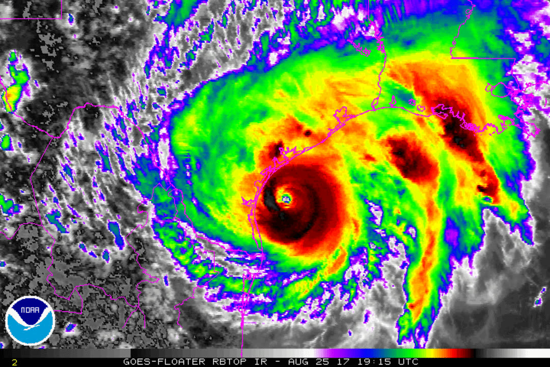
SATELLITE NOAA / NESDIS
Enhanced infrared satellite loop of Harvey intensifying to Category 4 on landfall day, August 25, 2017
FLOOD Texas Army National Guard
Texas National Guard soldiers moving residents out of flooded Houston neighborhoods by boat, August 2017
FLOOD U.S. National Guard
High-water rescue operations in southeast Texas as Harvey's rain kept falling, August 28, 2017
MAP NOAA / WPC
Storm-total rainfall — 60.58 inches at Nederland, TX, the heaviest tropical-cyclone rainfall in U.S. records

The storm

Harvey's remnants regenerated in the Bay of Campeche on August 23, 2017, and intensified explosively — tropical depression to 130 mph Category 4 in under 60 hours. It made landfall on San Jose Island near Rockport, Texas at 10 p.m. CDT on August 25 with a 937 mb pressure: the first Category 4 to hit the U.S. since 2004.

Then it stopped. Steering currents collapsed, and Harvey spent five days drifting between the coast and the Gulf, training rain bands over the same counties. Nederland, Texas measured 60.58 inches — the heaviest tropical-cyclone rainfall in U.S. records — and much of metro Houston took 30 to 45 inches. Harvey made a final landfall in southwest Louisiana on August 30 and dissipated. The toll: 68 direct deaths and about $125 billion in damage, tying Katrina as the costliest U.S. disaster on record.
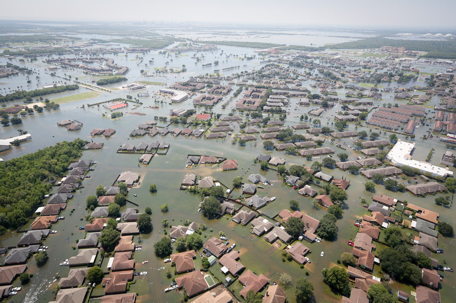
Texas National Guard soldiers moving residents out of flooded Houston neighborhoods by boat, August 2017
Texas National Guard soldiers moving residents out of flooded Houston neighborhoods by boat, August 2017 Texas Army National Guard

The damage

Rockport, Fulton, and Port Aransas took Category 4 wind at the core — collapsed buildings, destroyed marinas, surge through the bayfront. But more than 90 percent of Harvey's damage was freshwater flood. Harris County alone flooded on the order of 154,000 homes as every major bayou left its banks. Emergency releases from the Addicks and Barker reservoirs — begun August 28 to protect the dams — flooded thousands of additional homes downstream that had stayed dry through the rain itself. Port Arthur flooded nearly citywide; Beaumont lost its water system. Thirty-six of the 68 direct deaths were drownings in Harris County.
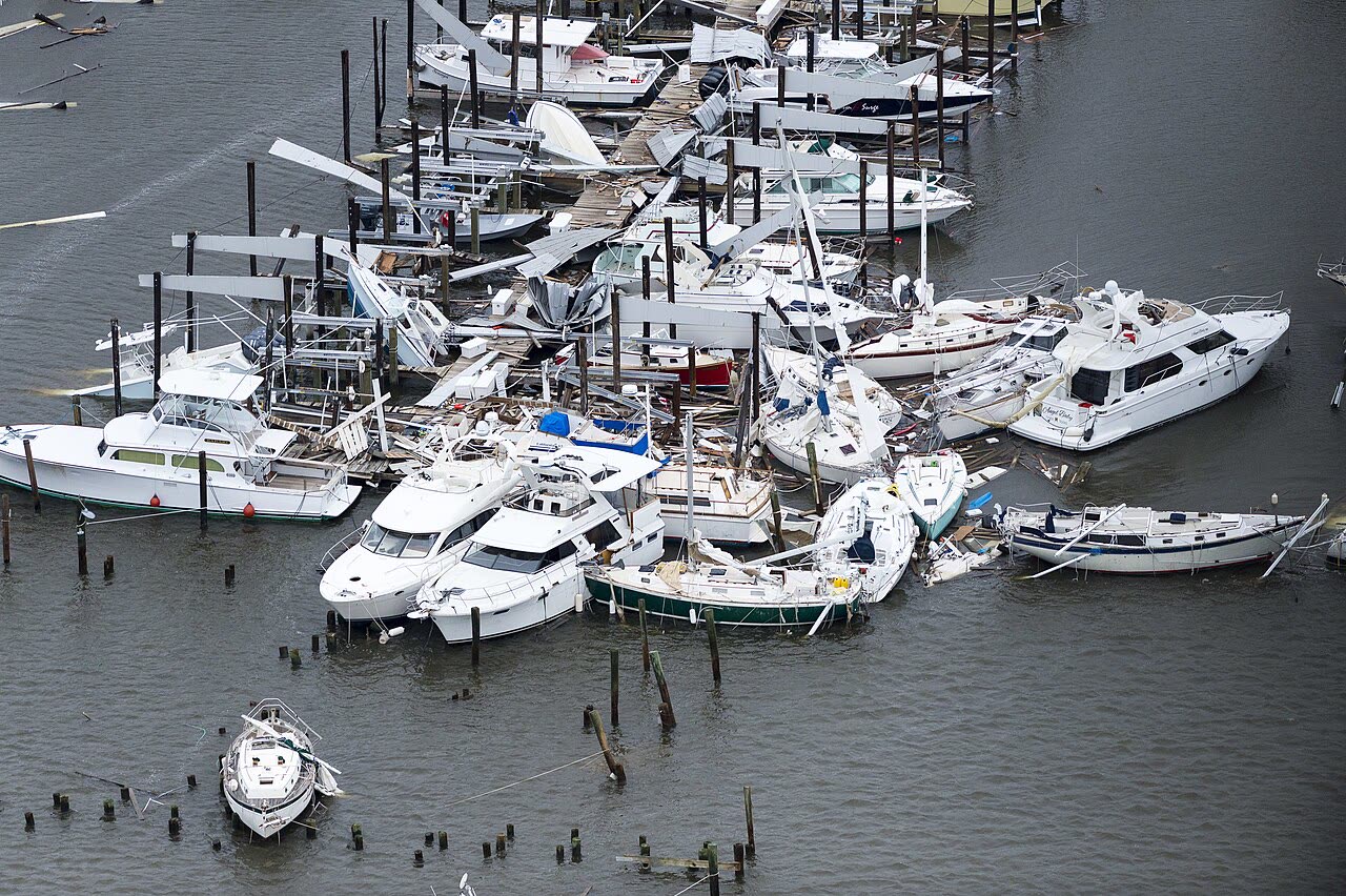
High-water rescue operations in southeast Texas as Harvey's rain kept falling, August 28, 2017
High-water rescue operations in southeast Texas as Harvey's rain kept falling, August 28, 2017 U.S. National Guard

The insurance aftermath

Harvey was the flood-gap disaster. Roughly 80 percent of flooded Harris County homes carried no flood insurance; homeowners policies exclude rising water entirely. The NFIP paid out about $8.9 billion to Texas policyholders who had coverage — average payments many times larger than the FEMA disaster grants (capped, and averaging a few thousand dollars) that uninsured households received instead.

The Texas Department of Insurance's final data call counted about 765,000 claims across all lines and roughly $20 billion in ultimate insured losses. Buried in that report is the defining number: of 261,860 homeowners claims, 63 percent closed without payment — mostly because the damage was flood, and the homeowners policy didn't cover it. Wind-versus-water allocation fights concentrated in the Coastal Bend, where surge and Category 4 wind hit the same structures; inland, "wind-driven rain" arguments over roof openings versus rising water drove the residential disputes.

Harvey also arrived six days before Texas law changed. HB 1774, passed in May 2017 and effective September 1, rewrote lawsuits over weather-related property claims: a 61-day pre-suit notice requirement, penalty interest on late-paid claims cut from 18 to 10 percent, and limits on attorney-fee recovery. The effective date triggered a documented rush of tens of thousands of claims and notices filed in the final week of August — policyholders acting to preserve the older, stronger remedies. The law applies to suits against carriers, not to the claim filing itself, but it permanently lowered the cost of slow-paying Texas storm claims.

Downstream of the reservoir releases, flooded owners sued the federal government instead of insurers — and in 2019 the Court of Federal Claims held the upstream flooding was a compensable taking, an ongoing litigation track separate from insurance entirely.
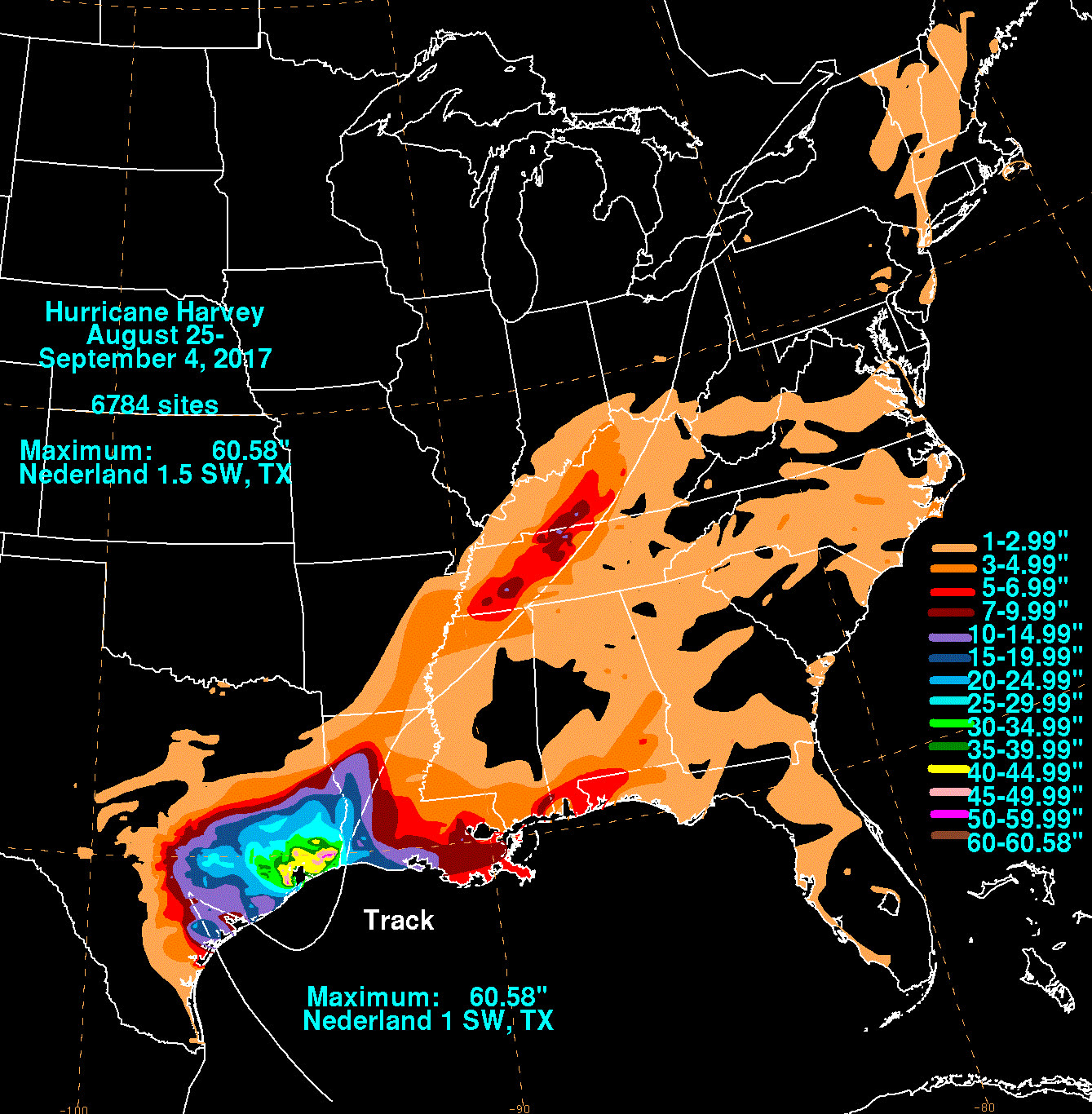
Storm-total rainfall — 60.58 inches at Nederland, TX, the heaviest tropical-cyclone rainfall in U.S. records
Storm-total rainfall — 60.58 inches at Nederland, TX, the heaviest tropical-cyclone rainfall in U.S. records NOAA / WPC

What policyholders learned

  • The flood exclusion, again, was the whole ballgame. Households a block apart had opposite outcomes based on one pre-storm purchase decision. Texas' 63 percent closed-without-payment homeowners rate was overwhelmingly a coverage gap, not adjuster misconduct.
  • NFIP coverage beat FEMA aid by an order of magnitude. Flood-insured households averaged high-five-figure recoveries; uninsured neighbors got capped grants and SBA loan offers.
  • Legal deadlines can move mid-claim. HB 1774's September 1 effective date taught Texas policyholders that the remedies available at filing time — not loss time — can control; filing promptly locked in rights.
  • Government-caused flooding is a different claim. Addicks/Barker release victims recovered through takings litigation, not policies — identifying why water entered the home changed the entire recovery path.
  • Wind-driven rain disputes turned on the opening. Carriers paid interior water damage only where policyholders documented a storm-created opening (roof breach, broken window) — photos taken before tarping made those claims.

Independent informational resource — not legal advice. Damage figures are nominal (not inflation-adjusted) unless noted. Insurance-law summaries are drafted for education; consult an attorney about your specific claim.

AT LANDFALL · HURRICANE HARVEY · 2017
6-10 ft
OF STORM SURGE · COASTAL BEND
HURRICANELAW.PRO FIELD FOOTAGE
03 THE FULL RECORD

Every official record of Harvey

Reports, imagery archives, flood data, and claims records — straight from the agencies.

OUR LAW FIRM PARTNER · HALVERSEN LAW
Harvey claim denied?
CALL FL941-390-3233CALL SC843-542-0454FREE CLAIM REVIEW
RELATED GUIDES
HurricaneLaw.Pro HURRICANELAW.PRO

The independent policyholder resource for Florida & South Carolina — storm archive, coverage law, denials, bad faith, and the complete claims playbook. 51 storms · 46 carriers · 97 public-adjuster firms · 37 city guides.

▸ SEE THE FULL SITE MAP — EVERY PAGE →
STORM ALERTS SOURCED FROM NOAA / NHC
SOUTH CAROLINA
496 Bramson Court, Suite 100
Mount Pleasant, SC 29464
CALL OR TEXT
FLORIDA
Tampa, FL
CALL OR TEXT
CLAIMS 9
DENIALS 8
BAD FAITH 7
COVERAGE 12
COMMERCIAL 8
ROOFS 8
TREES 5
DIRECTORIES
STORMS 51
WEATHER
NEWS & SITE 19
STORM ARCHIVE, CITIES & NEWS
Most recent below. Every storm dossier, city resource, and article is on its hub (linked at each heading) or the grouped site map →. All 46 carriers and 97 public-adjuster firms are in the Directories column above.
STORM ARCHIVE · 51 →
Hurricane Debby 2024Hurricane Helene 2024Hurricane Milton 2024Hurricane Idalia 2023Hurricane Ian 2022Hurricane Nicole 2022Hurricane Ida 2021Hurricane Laura 2020 View all 51 →
FLORIDA CITY RESOURCES · 29 →
Boca RatonBradentonCape CoralClearwaterDaytona BeachDestinFort LauderdaleFort Myers View all 29 →
SOUTH CAROLINA CITY RESOURCES · 8 →
BeaufortCharlestonColumbiaFlorenceGreenvilleHilton Head IslandMount PleasantMyrtle Beach
NEWS & UPDATES · 19 →

HurricaneLaw.Pro is an independent informational resource, not a law firm. Coverage summaries, policy-language quotations, dollar figures, deadlines, and chart examples throughout this site are general information based on typical or standard policy forms and are illustrative only — they are not a quote, a guarantee of coverage, or a promise of any outcome. Every insurance policy is different: your own policy, endorsements, and state law control, so read your policy and confirm current statutes. Weather imagery courtesy of NOAA, the National Hurricane Center, and the National Weather Service. Legal services are provided by our law firm partner, Halversen Law. Nothing on this site is legal advice; consult an attorney about your specific claim.

PrivacyTermsDisclaimerAboutContact
© 2026 HURRICANELAW.PRO — ALL RIGHTS RESERVED 27.9°N 82.5°W · ATLANTIC BASIN MONITOR
OUR LAW FIRM PARTNER
Halversen Law LICENSED · FLORIDA & SOUTH CAROLINA

All legal matters on this site are referred to and handled by our law firm partner, Halversen Law, a licensed law firm in Florida and South Carolina. HurricaneLaw.Pro is an informational resource and is not itself a law firm.

FREE CASE REVIEW