
PROPERTY-INSURANCE CLAIM HELP · FL & SC FL CITIESSC CITIESGUIDESTATESNEWSSITE MAPABOUT
HurricaneLaw.Pro HURRICANELAW.PRO
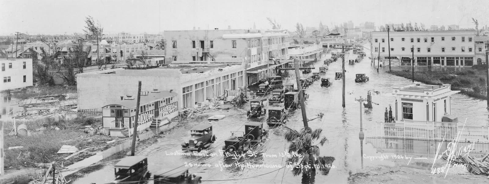
Flagler Street, downtown Miami, 24 hours after the September 18, 1926 landfall
STORM ARCHIVE / 1926 LANDFALL 25.6°N 80.3°W
CAT 4 FL · 1926 · 150 mph

Great Miami Hurricane

Landfall: Miami / Coconut Grove, FL · 1926-09-18. Burst the Florida land boom — and remains the costliest U.S. hurricane ever when normalized to today's coastline, at $200B+

Verne O. Williams (1926, public domain)
AT LANDFALL
CAT 4
PEAK WIND
150 mph
PRESSURE
930 mb
STORM SURGE
14–15 ft
DAMAGE
~$100M (1926)
DEATHS
372+
01 THE PATH

Where it hit, start to finish

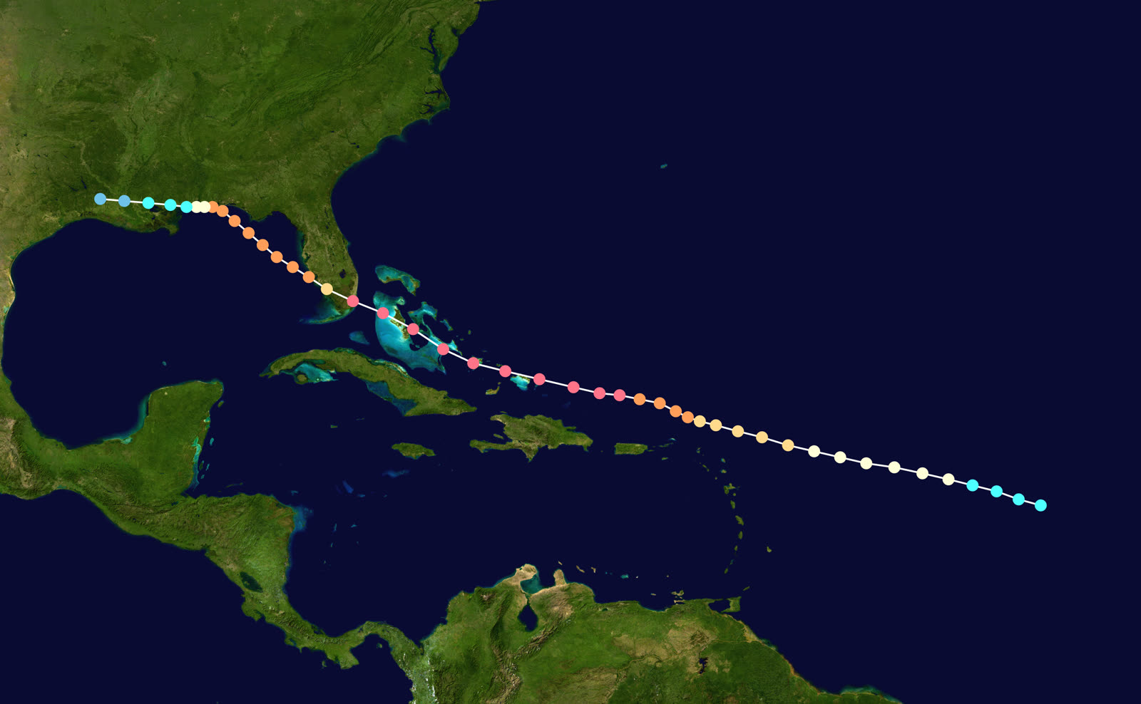
TRACK · GREAT MIAMI HURRICANENOAA / NHC (best-track data)
Best track of the Great Miami Hurricane, September 11–22, 1926
Bahamas / Florida Straits
LITTLE WARNING

The Category 4 crossed the Bahamas on September 17. Warnings reached Miami only hours before landfall, in a city full of newcomers who had never seen a hurricane.

Miami / Miami Beach
CAT 4 LANDFALL — EYE LULL DEATHS

Landfall near Perrine before dawn September 18 at 930 mb, ~145 mph. During the calm eye, residents walked outside; the back half of the storm and a 10–15 ft surge caught them in the open. Miami counted 114 dead, roughly 43,000 homeless.

Moore Haven / Lake Okeechobee
MUCK DIKE FAILURE

Wind-driven lake water burst the low muck dikes; Moore Haven's buildings were swept off their foundations and about 150 bodies were confirmed, with estimates near 300.

Gulf of Mexico
RE-INTENSIFICATION

The hurricane crossed the peninsula, emerged near Punta Rassa with 11–12 ft surge on the southwest coast, and re-strengthened to Category 3 over the Gulf.

Pensacola / Perdido Beach, AL
SECOND U.S. LANDFALL

A 115-mph landfall on September 20; Pensacola took 20+ hours of hurricane-force winds and lost nearly all waterfront structures. The storm dissipated over Louisiana September 22.

02 THE RECORD IN IMAGES
ALL IMAGERY U.S. GOV / PUBLIC DOMAIN
SURGE Public domain (1926 archival photo)
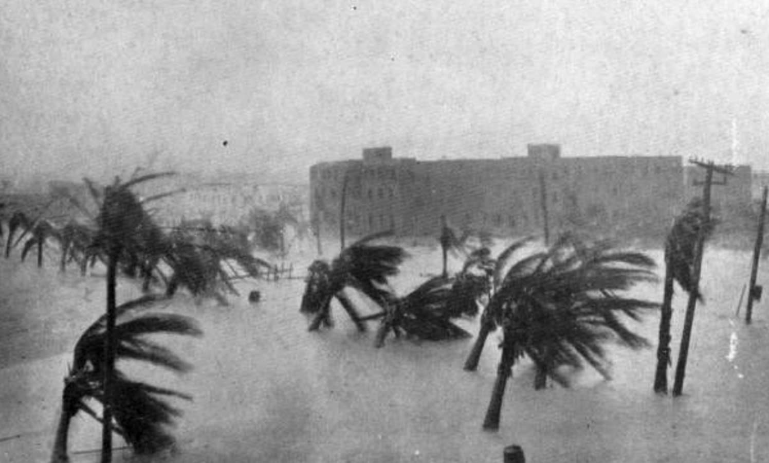
Storm-surge flooding on Miami Beach — Biscayne Bay surge reached 14–15 ft at Coconut Grove
DAMAGE Public domain (1926 archival photo)
Home destroyed on Miami Beach; multi-story buildings collapsed along the oceanfront
DAMAGE Library of Congress
Panorama of wrecked vessels and Miami's drydock after the hurricane
MAP NOAA Central Library (U.S. Weather Bureau)
U.S. Weather Bureau surface map, September 18, 1926 — the hurricane at the Florida coast

The storm

The hurricane formed in the central Atlantic on September 11, 1926, and moved west with almost no advance detection — no satellites, no radar, no reconnaissance aircraft. It crossed the Bahamas at Category 4 strength on September 17. Miami received hurricane warnings only hours before the eye arrived.

Landfall came before dawn on September 18 near Perrine, just south of downtown Miami, at 930 mb with sustained winds near 145 mph. Biscayne Bay surge reached 14–15 feet at Coconut Grove. The eye passed directly over the city, and the lull became the storm's signature tragedy: residents who had never experienced a hurricane walked outside into the calm, and the back eyewall and surge caught them in the open.

The storm crossed the peninsula, drove Lake Okeechobee over its muck dikes at Moore Haven, re-intensified over the Gulf, and made a second U.S. landfall at Perdido Beach, Alabama on September 20, battering Pensacola for more than 20 hours before dissipating over Louisiana.
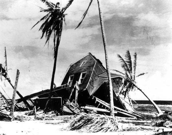
Home destroyed on Miami Beach; multi-story buildings collapsed along the oceanfront
Home destroyed on Miami Beach; multi-story buildings collapsed along the oceanfront Public domain (1926 archival photo)

The damage

The Red Cross count: 372 dead, 6,381 injured, about 43,000 homeless — in a metro area of roughly 100,000. Estimates including the missing run above 500. Moore Haven alone confirmed about 150 dead when the lake dikes failed, a rehearsal for the far larger Okeechobee disaster two years later.

Miami Beach casinos and oceanfront homes collapsed. Hialeah reported hundreds of working-class homes leveled and 70% of the town damaged. In Fort Lauderdale, 3,500 of 12,000 buildings were severely damaged. State Road A1A washed away in Broward and Miami-Dade; the MacArthur Causeway sat under six feet of water. Direct damage: about $100 million in 1926 dollars, roughly $75 million of it in Florida.
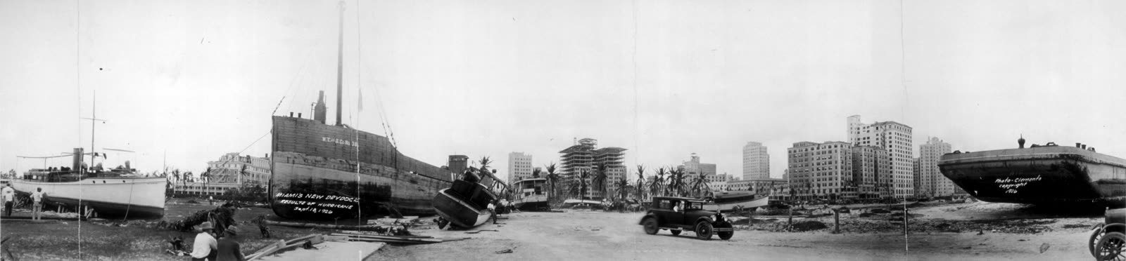
Panorama of wrecked vessels and Miami's drydock after the hurricane
Panorama of wrecked vessels and Miami's drydock after the hurricane Library of Congress

The insurance aftermath

The 1926 storm hit before hurricane insurance was a meaningful product. Homeowners of the era carried fire policies; windstorm protection was an uncommon add-on, and flood/surge losses had no insurance market at all. Most of the loss fell on property owners, banks, and the Red Cross relief system — not carriers.

The macro consequences were larger than any claim file. The hurricane ended the Florida land boom outright: tourism collapsed in 1927, land buyers defaulted in waves, and thousands of newcomers left the state and emptied their accounts. Florida and Georgia had already seen 117 banks close in a ten-day panic in July 1926; the storm accelerated the failures. Historians treat the hurricane as the start of Florida's Great Depression, three years early. Full recovery waited until the 1940s.

Two durable institutions came out of the wreckage. First, building regulation: Miami Beach appointed John J. Farrey chief building inspector, and he initiated and enforced the first building code in the United States — a code more than 5,000 U.S. cities later copied. Second, the benchmark itself: wealth-normalization studies rank the 1926 storm as the costliest U.S. hurricane in history if it struck today's coastline — $235.9 billion in one 2018 estimate, $140–157 billion in an earlier 2005 study. Modern Florida reinsurance and rate filings still model "a 1926 repeat" as a market-breaking scenario.
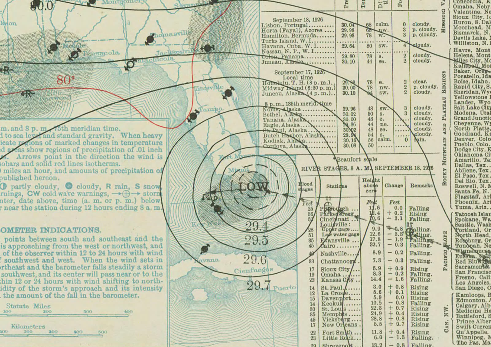
U.S. Weather Bureau surface map, September 18, 1926 — the hurricane at the Florida coast
U.S. Weather Bureau surface map, September 18, 1926 — the hurricane at the Florida coast NOAA Central Library (U.S. Weather Bureau)

What policyholders learned

  • Uninsured perils fall on the owner. In 1926 that meant nearly everything; today it still means surge and flood unless a separate flood policy exists before the storm.
  • The eye is not the end. The deadliest minutes came after the calm. The same logic applies to claims: second-half wind and surge damage is distinct evidence — document each phase.
  • Codes exist because of this storm. Repairs that meet current code have been the recoverable standard ever since; code-upgrade (ordinance or law) coverage traces to lessons first written into the 1926-era Miami Beach code.
  • Market collapse follows unpaid losses. Banks, not carriers, absorbed the 1926 loss, and the regional economy broke. It is the founding argument for why paid claims — not relief — stabilize a disaster economy.
  • Normalized history sets today's rates. The 1926 storm is the reference catastrophe in Florida windstorm ratemaking; policyholders are still paying for its return period.

Independent informational resource — not legal advice. Damage figures are nominal (not inflation-adjusted) unless noted. Insurance-law summaries are drafted for education; consult an attorney about your specific claim.

AT LANDFALL · GREAT MIAMI HURRICANE · 1926
14–15 ft
OF STORM SURGE · COCONUT GROVE, BISCAYNE BAY
HURRICANELAW.PRO FIELD FOOTAGE
03 THE FULL RECORD

Every official record of Great Miami Hurricane

Reports, imagery archives, flood data, and claims records — straight from the agencies.

OUR LAW FIRM PARTNER · HALVERSEN LAW
Great Miami Hurricane claim denied?
CALL FL941-390-3233CALL SC843-542-0454FREE CLAIM REVIEW
RELATED GUIDES
HurricaneLaw.Pro HURRICANELAW.PRO

The independent policyholder resource for Florida & South Carolina — storm archive, coverage law, denials, bad faith, and the complete claims playbook. 51 storms · 46 carriers · 97 public-adjuster firms · 37 city guides.

▸ SEE THE FULL SITE MAP — EVERY PAGE →
STORM ALERTS SOURCED FROM NOAA / NHC
SOUTH CAROLINA
496 Bramson Court, Suite 100
Mount Pleasant, SC 29464
CALL OR TEXT
FLORIDA
Tampa, FL
CALL OR TEXT
CLAIMS 9
DENIALS 8
BAD FAITH 7
COVERAGE 12
COMMERCIAL 8
ROOFS 8
TREES 5
DIRECTORIES
STORMS 51
WEATHER
NEWS & SITE 19
STORM ARCHIVE, CITIES & NEWS
Most recent below. Every storm dossier, city resource, and article is on its hub (linked at each heading) or the grouped site map →. All 46 carriers and 97 public-adjuster firms are in the Directories column above.
STORM ARCHIVE · 51 →
Hurricane Debby 2024Hurricane Helene 2024Hurricane Milton 2024Hurricane Idalia 2023Hurricane Ian 2022Hurricane Nicole 2022Hurricane Ida 2021Hurricane Laura 2020 View all 51 →
FLORIDA CITY RESOURCES · 29 →
Boca RatonBradentonCape CoralClearwaterDaytona BeachDestinFort LauderdaleFort Myers View all 29 →
SOUTH CAROLINA CITY RESOURCES · 8 →
BeaufortCharlestonColumbiaFlorenceGreenvilleHilton Head IslandMount PleasantMyrtle Beach
NEWS & UPDATES · 19 →

HurricaneLaw.Pro is an independent informational resource, not a law firm. Coverage summaries, policy-language quotations, dollar figures, deadlines, and chart examples throughout this site are general information based on typical or standard policy forms and are illustrative only — they are not a quote, a guarantee of coverage, or a promise of any outcome. Every insurance policy is different: your own policy, endorsements, and state law control, so read your policy and confirm current statutes. Weather imagery courtesy of NOAA, the National Hurricane Center, and the National Weather Service. Legal services are provided by our law firm partner, Halversen Law. Nothing on this site is legal advice; consult an attorney about your specific claim.

PrivacyTermsDisclaimerAboutContact
© 2026 HURRICANELAW.PRO — ALL RIGHTS RESERVED 27.9°N 82.5°W · ATLANTIC BASIN MONITOR
OUR LAW FIRM PARTNER
Halversen Law LICENSED · FLORIDA & SOUTH CAROLINA

All legal matters on this site are referred to and handled by our law firm partner, Halversen Law, a licensed law firm in Florida and South Carolina. HurricaneLaw.Pro is an informational resource and is not itself a law firm.

FREE CASE REVIEW