
PROPERTY-INSURANCE CLAIM HELP · FL & SC FL CITIESSC CITIESGUIDESTATESNEWSSITE MAPABOUT
HurricaneLaw.Pro HURRICANELAW.PRO
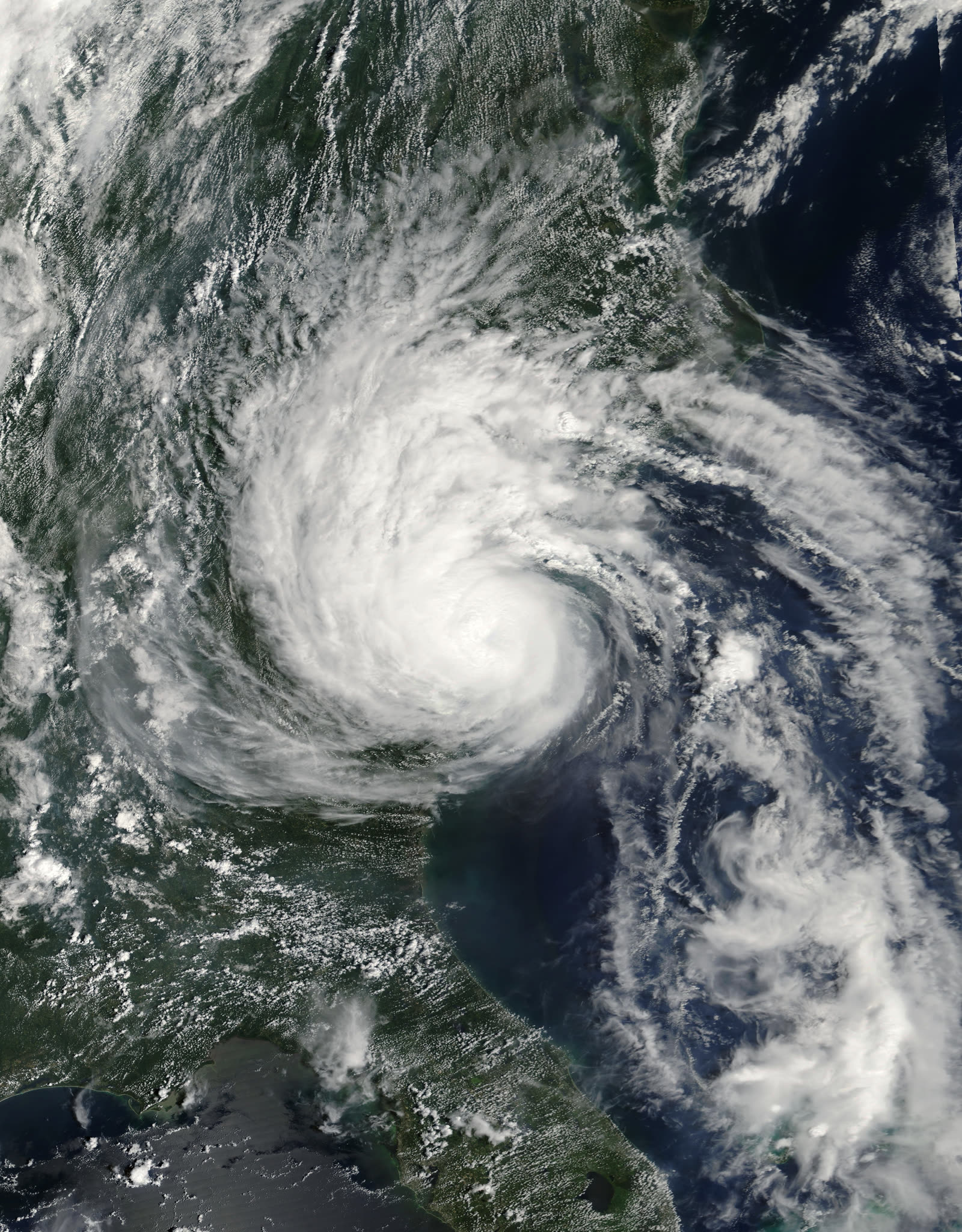
Gaston at hurricane strength just off the South Carolina coast, hours before landfall at Awendaw, August 29, 2004
STORM ARCHIVE / 2004 LANDFALL 33.0°N 79.6°W
CAT 1 SC · 2004 · 75 mph

Hurricane Gaston

Landfall: Awendaw, SC (Bulls Bay) · 2004-08-29. Wind at the SC coast, a 1,000-year flash flood in Richmond — where the flood wall had taken Shockoe Bottom off the flood maps, so almost nobody carried flood insurance

NOAA / NESDIS
AT LANDFALL
CAT 1
PEAK WIND
75 mph
PRESSURE
985 mb
STORM SURGE
4.5 ft
DAMAGE
~$130M
DEATHS
8 direct
01 THE PATH

Where it hit, start to finish

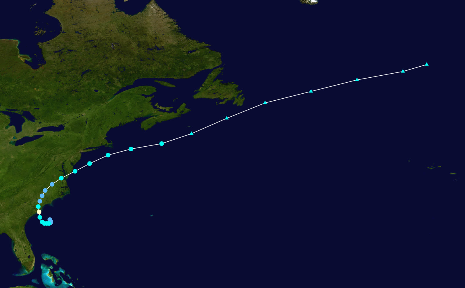
TRACK · HURRICANE GASTONNOAA / NHC (best-track data)
Best track and intensity of Hurricane Gaston, August 27-September 1, 2004 — born off the SC coast, dead over the Atlantic after drowning Richmond
Offshore SC
HOME-GROWN STORM

Gaston formed from a stalled front just off the South Carolina coast on August 27, 2004 — a local storm with a two-day fuse, upgraded to hurricane strength in post-analysis.

Awendaw / Bulls Bay, SC
CAT 1 LANDFALL - 75 MPH

Landfall the morning of August 29 at Awendaw with 75 mph winds, 985 mb pressure, and 4.5 feet of surge in Bulls Bay — the same bay Hugo had filled with 20 feet fifteen years earlier.

Kingstree / Williamsburg County, SC
10.98 INCHES OF RAIN

Gaston crawled inland at under 10 mph, dropping up to 10.98 inches at Kingstree. The Black River crested nearly 8 feet above flood stage; about 172,000 South Carolinians lost power. SC insured damage: roughly $20 million.

Richmond, VA - West End
12.60 INCHES IN HOURS

On August 30 the depression stalled over Richmond and trained bands dropped up to 12.60 inches, most of it in a few hours — later judged a 1,000-year rainfall event for the city.

Richmond, VA - Shockoe Bottom
10-FT FLASH FLOOD, 20 BLOCKS CONDEMNED

Runoff funneled into the historic bottom below the flood wall: water reached 10 feet deep, 580 buildings were damaged or destroyed, 20 downtown blocks were condemned, and 8 people died — 5 in vehicles, 3 in rescue attempts. VA insured damage: about $30 million of a far larger total.

Atlantic
OUT TO SEA

Gaston re-emerged over the Chesapeake, brushed the mid-Atlantic coast, and died at sea September 1. Total damage: about $130 million, the bulk of it uninsured Virginia flood loss.

02 THE RECORD IN IMAGES
ALL IMAGERY U.S. GOV / PUBLIC DOMAIN
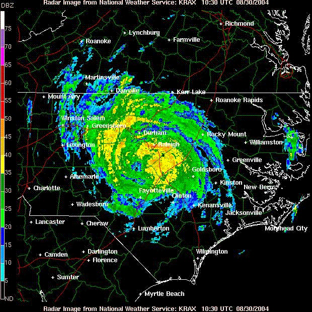
RADAR NOAA / NWS
Radar image of Gaston after landfall — training rain bands that would later stall over central Virginia
FLOOD FEMA / Liz Roll
Cleanup at Richmond's Main Street Station in Shockoe Bottom, where floodwater reached 10 feet deep
DAMAGE FEMA / Liz Roll
A Richmond-area resident surveys severe damage at Walker Village trailer park after Gaston's flood
FLOOD FEMA
Washout on E. Grace Street, Richmond — Gaston's runoff carved through streets as well as buildings
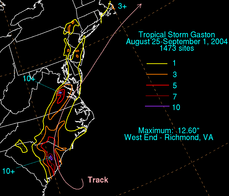
MAP NOAA / WPC
Gaston's rainfall footprint — 10.98 inches at Kingstree, SC and 12.60 inches in Richmond's West End

The storm

Gaston was a home-grown storm in a season dominated by long-track monsters. While Florida braced for Frances, Gaston spun up from a stalled front just off the South Carolina coast on August 27, 2004, and came ashore only two days later — the morning of August 29 — at Awendaw, on Bulls Bay northeast of Charleston. Operationally treated as a strong tropical storm, it was upgraded to a 75-mph Category 1 hurricane in NHC post-analysis, with 985 mb pressure and 4.5 feet of surge in Bulls Bay.

Wind was never Gaston's weapon. Moving inland at under 10 mph, it wrung out torrential rain over eastern South Carolina — 10.98 inches at Kingstree — then held together across North Carolina. On August 30 the depression stalled over Richmond, Virginia, and trained rain bands dropped up to 12.60 inches on the city's West End, most of it within a few hours. The National Weather Service later characterized the Richmond flood as a 1,000-year event. Gaston finally exited to sea and dissipated September 1.

Eight people died directly, five of them drivers who entered flooded roads. Total damage: about $130 million.
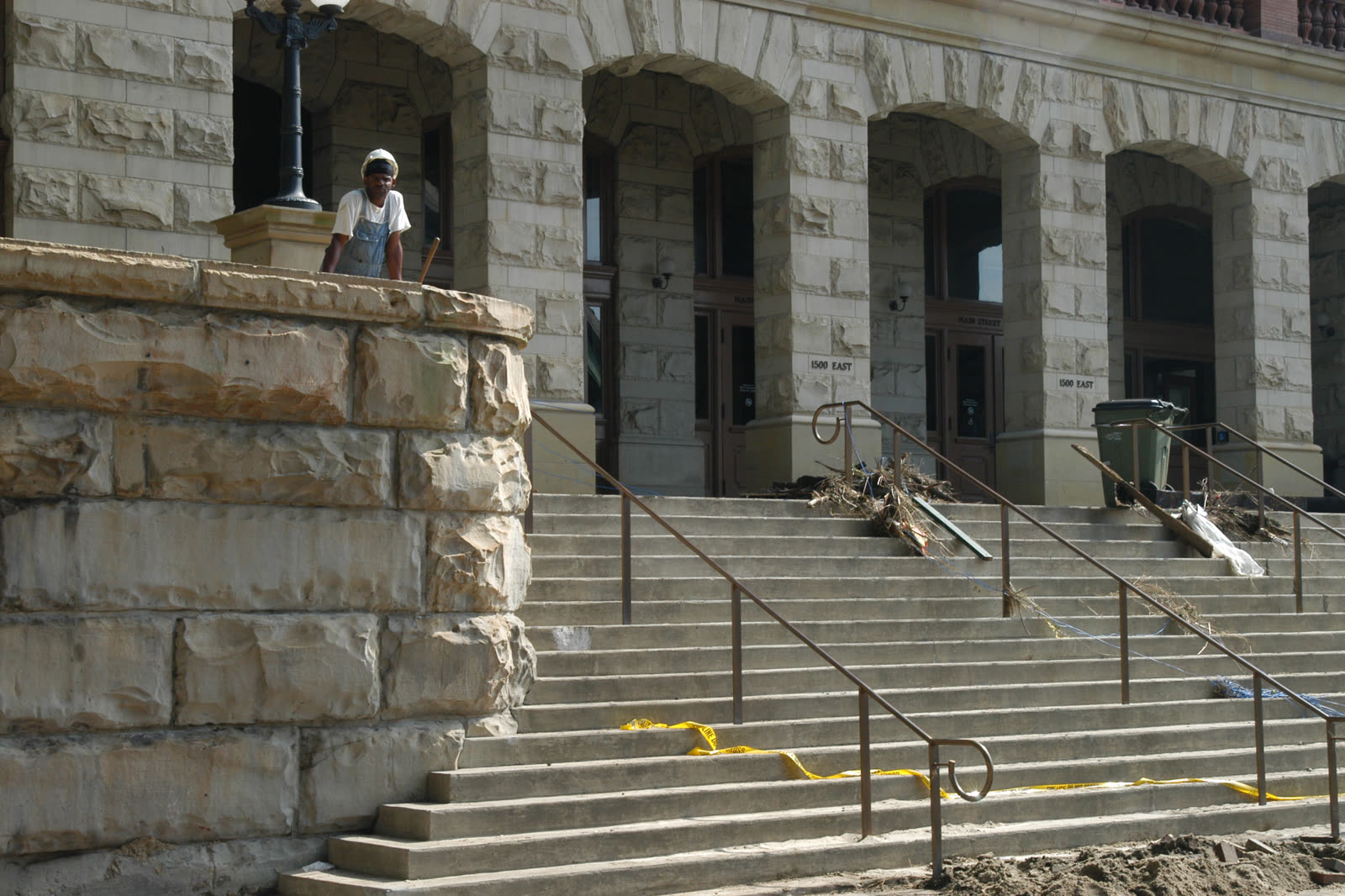
Cleanup at Richmond's Main Street Station in Shockoe Bottom, where floodwater reached 10 feet deep
Cleanup at Richmond's Main Street Station in Shockoe Bottom, where floodwater reached 10 feet deep FEMA / Liz Roll

The damage

In South Carolina, Gaston was a classic Category 1 inland-rain storm: trees and lines down from Awendaw through the Pee Dee, about 172,000 customers without power, and the Black River at Kingstree cresting nearly 8 feet above flood stage. Insured South Carolina damage ran about $20 million — mostly roofs, trees on structures, and food spoilage.

Richmond took the catastrophe. Runoff from the West End deluge funneled downhill into Shockoe Bottom, the historic low district that sits below the James River flood wall. Water rose to 10 feet in the streets. Some 580 buildings were damaged or destroyed, 20 downtown blocks were condemned, and the restaurant-and-warehouse district at the heart of Richmond's revival was gutted. Cars stacked in intersections; E. Grace Street washed out entirely. Virginia's insured tally — about $30 million — captured only a fraction of the loss, because most of it was flood.

A Richmond-area resident surveys severe damage at Walker Village trailer park after Gaston's flood
A Richmond-area resident surveys severe damage at Walker Village trailer park after Gaston's flood FEMA / Liz Roll

The insurance aftermath

Gaston's claims split cleanly by peril and by state. South Carolina's $20 million was wind — covered, routine, mostly settled inside standard homeowners policies, with the usual friction over tree-removal caps and spoilage sublimits.

Richmond exposed a flood-map trap. When the James River flood wall was completed in 1995, Shockoe Bottom came off the mapped floodplain — and with it went the mortgage-lender requirement to carry NFIP coverage. A decade later, almost no one in the Bottom had flood insurance when Gaston's runoff — rainwater coming downhill, which no flood wall addresses — filled the district to 10 feet. Homeowners and business policies denied the losses under the flood exclusion; the water never touched the river, but rising surface water is flood by policy definition regardless of source. Roughly 93,000 people registered with FEMA across the disaster, and Shockoe businesses rebuilt on SBA loans measured in the millions — one restaurateur spent nearly two decades paying off a seven-figure federal loan.

The event became a standing citation in flood-risk literature: protection infrastructure can remove the insurance requirement without removing the risk. For SC policyholders, Gaston is the cleanest local example of the wind-policy/flood-exclusion boundary — the identical storm produced covered claims at the coast and denied claims 300 miles inland, decided entirely by which peril delivered the water.
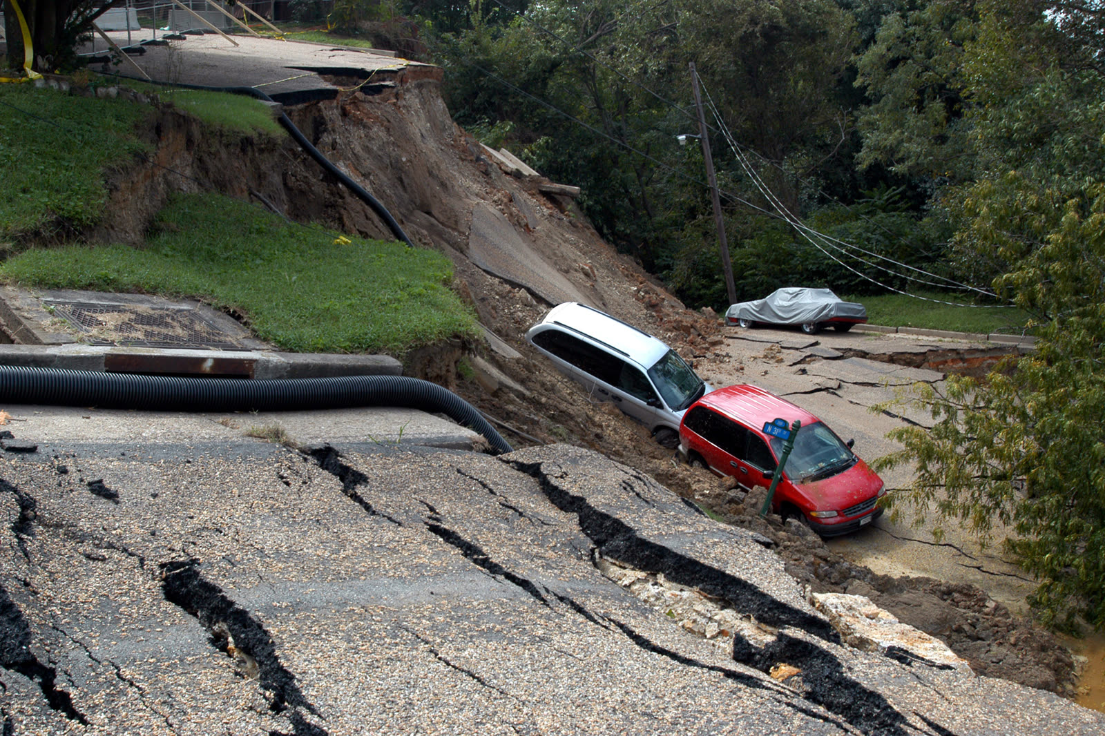
Washout on E. Grace Street, Richmond — Gaston's runoff carved through streets as well as buildings
Washout on E. Grace Street, Richmond — Gaston's runoff carved through streets as well as buildings FEMA

What policyholders learned

  • "Out of the flood zone" means the mortgage doesn't require insurance — not that flooding can't happen. Shockoe Bottom flooded to 10 feet nine years after being mapped out. Zone X owners can buy NFIP coverage cheaply; after Gaston, that math looked obvious.
  • Rainwater running downhill is still "flood." Policyholders argued the water was storm runoff, not river flooding; carriers denied under the exclusion's surface-water language and prevailed. The source of the water does not defeat the exclusion.
  • Inland counties carry hurricane flood risk with near-zero take-up. Kingstree's 11 inches and the Black River's crest previewed what 2015 proved statewide: SC flood insurance sits at the coast while hurricane rain falls inland.
  • Wind-driven rain was the fight in SC claims. Where wind opened a roof and rain followed, coverage applied; where rain entered without an opening, carriers denied. Photos of the roof breach, taken before repairs, decided the difference.
  • Slow, weak storms out-damage fast, strong ones. A 75-mph storm moving at 8 mph produced a 1,000-year flood. Deductibles, coverage, and preparation keyed to category miss the rain threat entirely.

Independent informational resource — not legal advice. Damage figures are nominal (not inflation-adjusted) unless noted. Insurance-law summaries are drafted for education; consult an attorney about your specific claim.

AT LANDFALL · HURRICANE GASTON · 2004
4.5 ft
OF STORM SURGE · BULLS BAY
HURRICANELAW.PRO FIELD FOOTAGE
03 THE FULL RECORD

Every official record of Gaston

Reports, imagery archives, flood data, and claims records — straight from the agencies.

OUR LAW FIRM PARTNER · HALVERSEN LAW
Gaston claim denied?
CALL FL941-390-3233CALL SC843-542-0454FREE CLAIM REVIEW
RELATED GUIDES
HurricaneLaw.Pro HURRICANELAW.PRO

The independent policyholder resource for Florida & South Carolina — storm archive, coverage law, denials, bad faith, and the complete claims playbook. 51 storms · 46 carriers · 97 public-adjuster firms · 37 city guides.

▸ SEE THE FULL SITE MAP — EVERY PAGE →
STORM ALERTS SOURCED FROM NOAA / NHC
SOUTH CAROLINA
496 Bramson Court, Suite 100
Mount Pleasant, SC 29464
CALL OR TEXT
FLORIDA
Tampa, FL
CALL OR TEXT
CLAIMS 9
DENIALS 8
BAD FAITH 7
COVERAGE 12
COMMERCIAL 8
ROOFS 8
TREES 5
DIRECTORIES
STORMS 51
WEATHER
NEWS & SITE 19
STORM ARCHIVE, CITIES & NEWS
Most recent below. Every storm dossier, city resource, and article is on its hub (linked at each heading) or the grouped site map →. All 46 carriers and 97 public-adjuster firms are in the Directories column above.
STORM ARCHIVE · 51 →
Hurricane Debby 2024Hurricane Helene 2024Hurricane Milton 2024Hurricane Idalia 2023Hurricane Ian 2022Hurricane Nicole 2022Hurricane Ida 2021Hurricane Laura 2020 View all 51 →
FLORIDA CITY RESOURCES · 29 →
Boca RatonBradentonCape CoralClearwaterDaytona BeachDestinFort LauderdaleFort Myers View all 29 →
SOUTH CAROLINA CITY RESOURCES · 8 →
BeaufortCharlestonColumbiaFlorenceGreenvilleHilton Head IslandMount PleasantMyrtle Beach
NEWS & UPDATES · 19 →

HurricaneLaw.Pro is an independent informational resource, not a law firm. Coverage summaries, policy-language quotations, dollar figures, deadlines, and chart examples throughout this site are general information based on typical or standard policy forms and are illustrative only — they are not a quote, a guarantee of coverage, or a promise of any outcome. Every insurance policy is different: your own policy, endorsements, and state law control, so read your policy and confirm current statutes. Weather imagery courtesy of NOAA, the National Hurricane Center, and the National Weather Service. Legal services are provided by our law firm partner, Halversen Law. Nothing on this site is legal advice; consult an attorney about your specific claim.

PrivacyTermsDisclaimerAboutContact
© 2026 HURRICANELAW.PRO — ALL RIGHTS RESERVED 27.9°N 82.5°W · ATLANTIC BASIN MONITOR
OUR LAW FIRM PARTNER
Halversen Law LICENSED · FLORIDA & SOUTH CAROLINA

All legal matters on this site are referred to and handled by our law firm partner, Halversen Law, a licensed law firm in Florida and South Carolina. HurricaneLaw.Pro is an informational resource and is not itself a law firm.

FREE CASE REVIEW