
PROPERTY-INSURANCE CLAIM HELP · FL & SC FL CITIESSC CITIESGUIDESTATESNEWSSITE MAPABOUT
HurricaneLaw.Pro HURRICANELAW.PRO
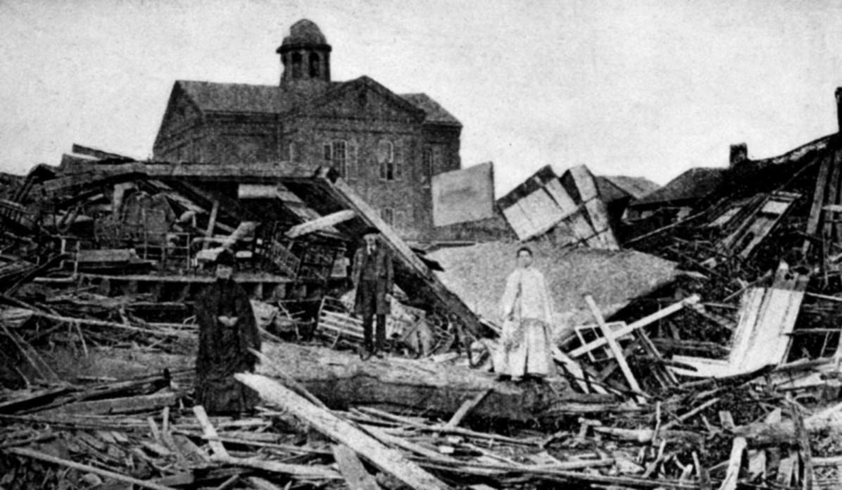
Wrecked homes in Galveston after the September 8, 1900 hurricane — 3,600+ houses were destroyed
STORM ARCHIVE / 1900 LANDFALL 29.1°N 95.1°W
CAT 4 US · 1900 · 145 mph

Galveston Hurricane

Landfall: Galveston, TX · 1900-09-08. Fire policies dominated in 1900 — windstorm ('tornado') coverage was a rarely purchased rider, so most of the 3,600+ destroyed homes carried no coverage against the storm

NOAA Photo Library
AT LANDFALL
CAT 4
PEAK WIND
145 mph
PRESSURE
936 mb
STORM SURGE
8-15 ft
DAMAGE
~$30M
DEATHS
8,000-12,000
01 THE PATH

Where it hit, start to finish

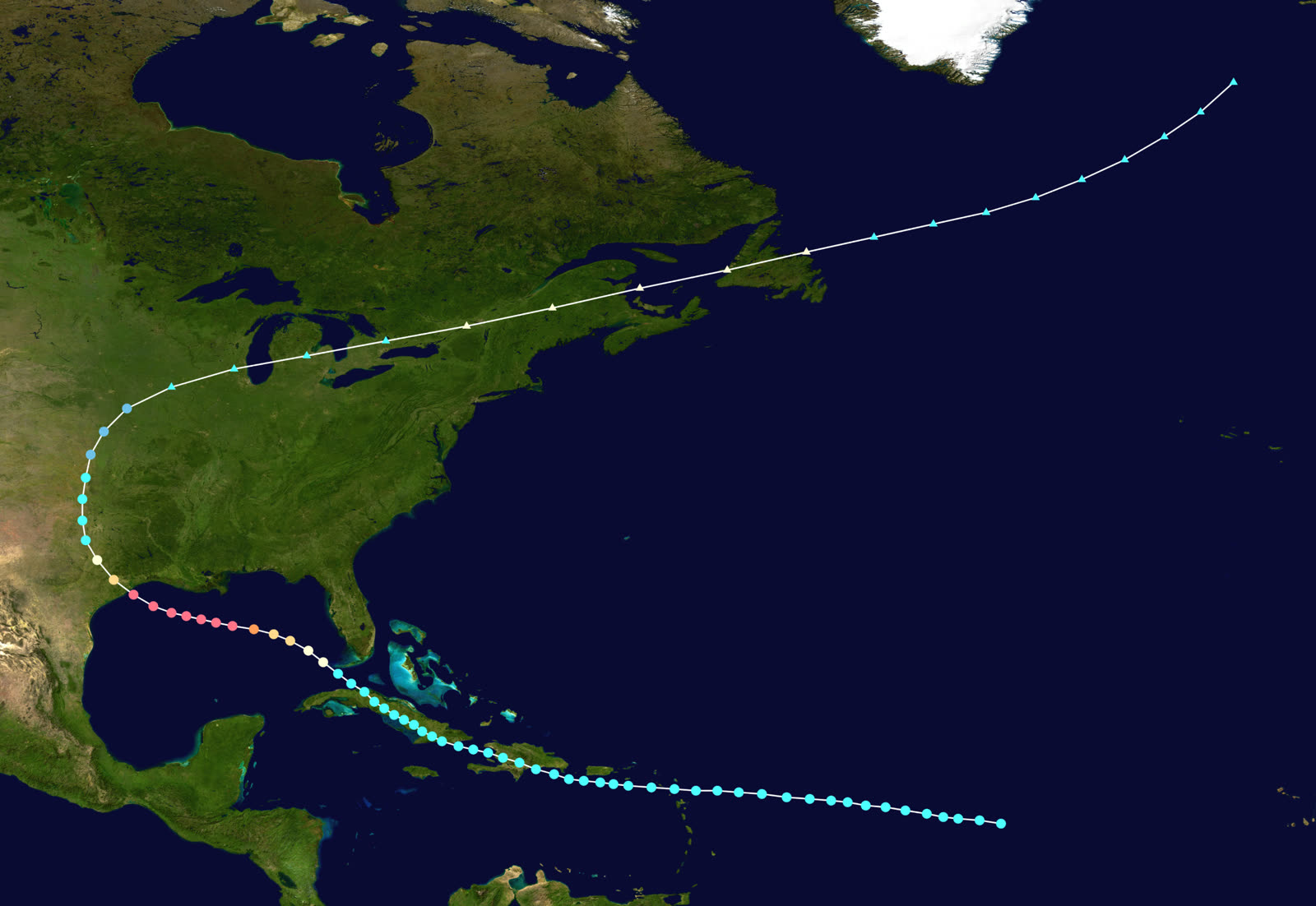
TRACK · GALVESTON HURRICANENOAA (HURDAT best-track data)
Best track of the 1900 Galveston hurricane, August 27 - September 15, 1900
Cuba / Straits of Florida
A STORM MISREAD

The system crossed Cuba as a tropical storm September 3-5. Cuban forecasters projected a Gulf track toward Texas; the U.S. Weather Bureau forecast an Atlantic recurve and issued no hurricane warning for the Texas coast.

Gulf of Mexico
INTENSIFICATION

Over the open Gulf September 6-7 the storm strengthened to an estimated Category 4 with 145 mph winds and a central pressure near 936 mb.

Galveston, TX
LANDFALL - SEPT 8, 1900

The hurricane struck the night of September 8. Storm tide of 8-15 feet submerged the entire island, whose highest point stood 8.7 feet above sea level. An estimated 8,000-12,000 people died - still the deadliest natural disaster in U.S. history.

Galveston Island
TOTAL DESTRUCTION ZONE

The city's insurance inspector counted 2,636 houses in the zone of total destruction and roughly 1,000 more destroyed elsewhere - about 3,636 homes gone. Damage assessments by insurers and the relief committee ran $17 million in Galveston, roughly $30 million along the full track.

Texas interior / Plains
INLAND DECAY

The storm moved inland over Texas September 9, weakened, then swept northeast through the Plains and Great Lakes, reaching New England and Canada as an extratropical storm by September 12-15.

02 THE RECORD IN IMAGES
ALL IMAGERY U.S. GOV / PUBLIC DOMAIN
MAP NOAA Photo Library
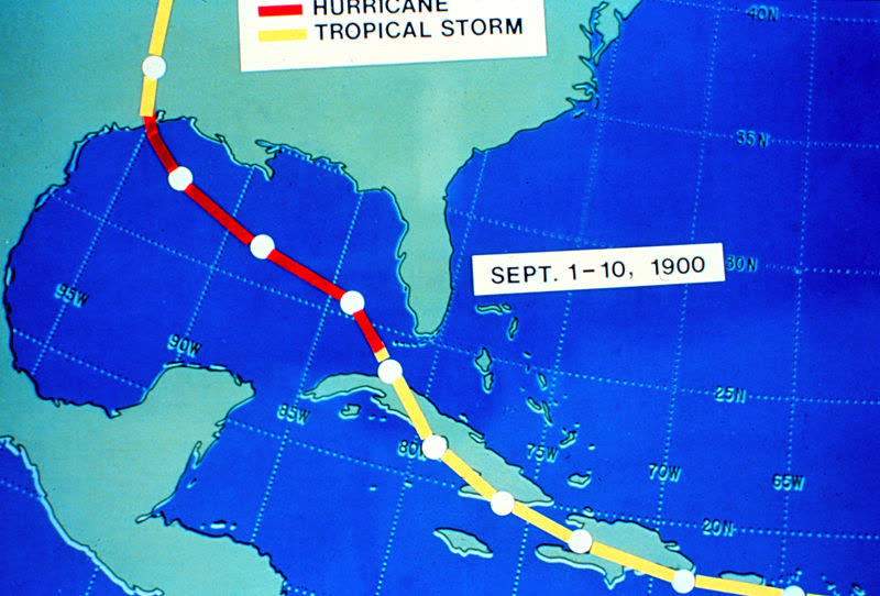
The Weather Bureau's own 1900 track chart of the hurricane's path from Cuba to Texas
MAP NOAA (Monthly Weather Review)
Surface weather map as the hurricane approached the Texas coast, September 1900
DAMAGE Library of Congress
A house tipped off its foundation by the storm surge — Galveston's highest ground stood 8.7 feet above sea level
DAMAGE Library of Congress
Residents searching the debris field — wreckage was piled in a ridge up to two stories high across the island
OTHER U.S. National Archives
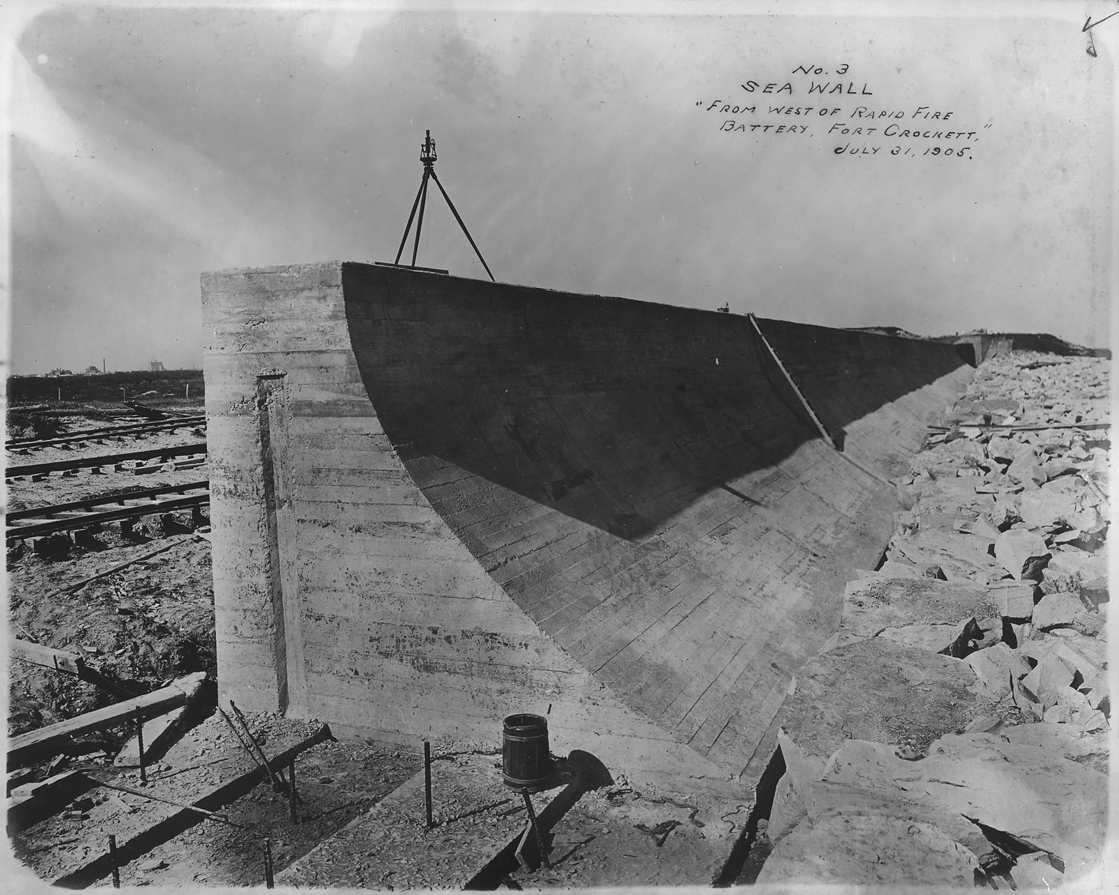
The Galveston Seawall under construction — the city's answer to a storm no policy had covered

The storm

The 1900 Galveston hurricane was first tracked over Cuba September 3-5. Cuban meteorologists projected it would enter the Gulf of Mexico and move toward Texas. The U.S. Weather Bureau forecast an Atlantic recurve instead and issued no hurricane warning for the Texas coast.

The storm crossed the Gulf September 6-7 and intensified to an estimated Category 4, with 145 mph winds and a central pressure near 936 mb. It struck Galveston the night of September 8, 1900.

Galveston was an island city of about 38,000 people whose highest point stood 8.7 feet above sea level. The storm tide reached 8-15 feet. The entire island went underwater. Between 8,000 and 12,000 people died — the deadliest natural disaster in United States history, a record that still stands 126 years later.
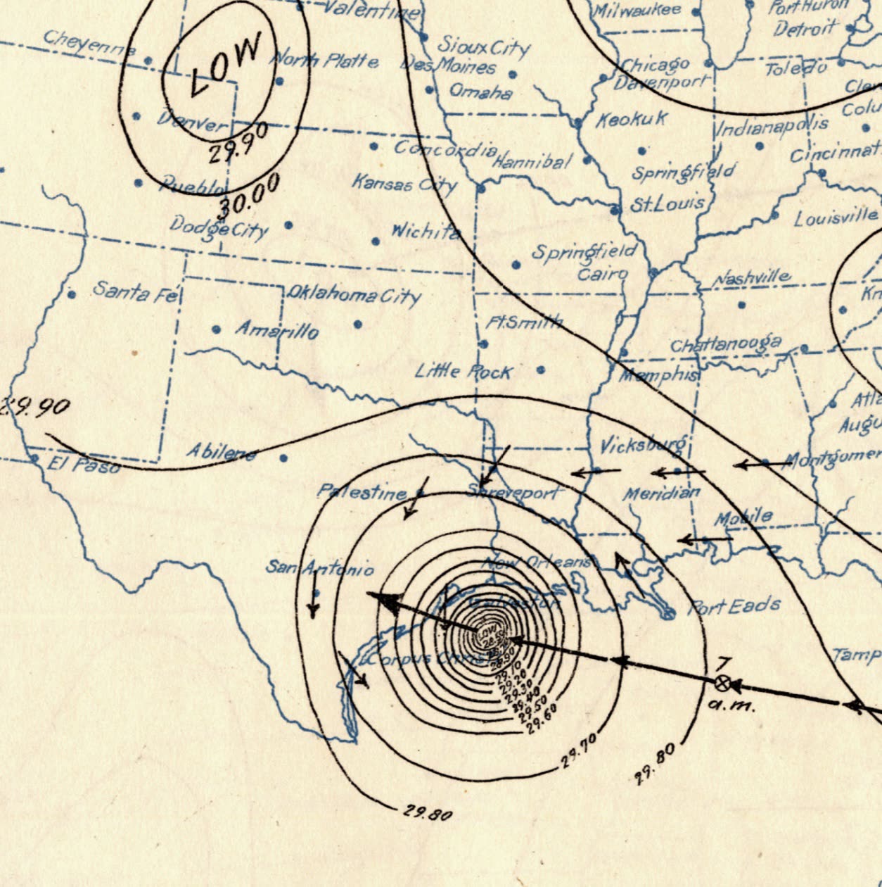
Surface weather map as the hurricane approached the Texas coast, September 1900
Surface weather map as the hurricane approached the Texas coast, September 1900 NOAA (Monthly Weather Review)

The damage

Wind and surge working together leveled the southern and eastern portions of the city. Structures collapsed into a moving wall of debris that scoured everything in its path, finally coming to rest as a ridge of wreckage up to two stories high running across the island.

The city's insurance inspector counted 2,636 residences in the zone of total destruction and estimated another 1,000 destroyed elsewhere — roughly 3,636 homes gone out of a city of 38,000 people. Damage assessments compiled by the Galveston Daily News, the Chamber of Commerce, multiple insurance companies, and the relief committee put losses at about $17 million in Galveston ($8.44 million of it residential), with total losses along the track near $30 million in 1900 dollars.

St. Mary's Orphan Asylum was destroyed with the loss of 90 children and 10 sisters. Wharves, cotton warehouses, rail causeways, and the water works all failed.
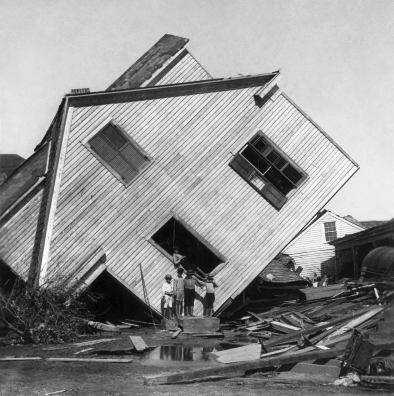
A house tipped off its foundation by the storm surge — Galveston's highest ground stood 8.7 feet above sea level
A house tipped off its foundation by the storm surge — Galveston's highest ground stood 8.7 feet above sea level Library of Congress

The insurance aftermath

There was no homeowners insurance in 1900 and no flood program of any kind. Property coverage meant a fire policy, and standard fire policies did not respond to wind or water. Windstorm protection existed only as "tornado insurance" — a separate rider that few Galveston property owners carried. The result: the overwhelming majority of the 3,636 destroyed homes produced no claim at all. Insurance company inspectors documented the destruction in detail — their counts remain a primary damage record — but payouts covered only a small fraction of the loss.

With insurance unable to fund recovery, Galveston engineered its way out instead, and that public response became the storm's insurance legacy. The county issued bonds to build a concrete seawall — begun September 1902, first three-mile segment completed July 1904, eventually 17 feet high. The city then raised its own grade: over 500 city blocks, some 2,100 buildings were jacked up and sand filled beneath them, lifting parts of the island as much as 17 feet. The state of Texas granted tax abatements to finance the work. When a comparable hurricane struck in 1915, the protected city's death toll was in the dozens, not the thousands.

The 1900 storm fixed two ideas that still run through every coastal claim: uninsured catastrophe risk lands on governments and survivors, and elevation and structural hardening — not indemnity alone — determine whether a coastal community survives. Galveston's seawall and grade raising are the direct ancestors of today's building codes, elevation requirements, and windstorm pools.
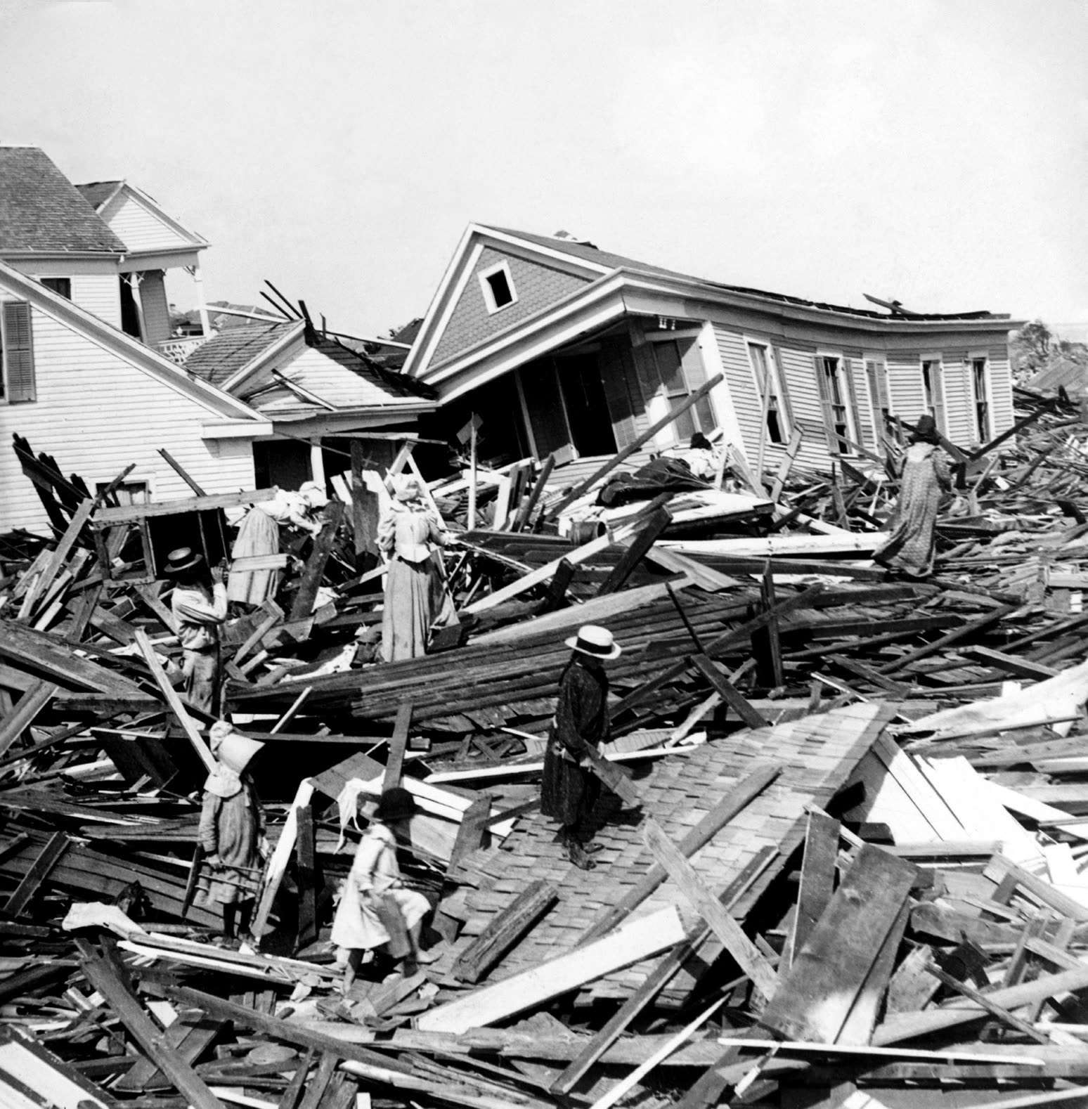
Residents searching the debris field — wreckage was piled in a ridge up to two stories high across the island
Residents searching the debris field — wreckage was piled in a ridge up to two stories high across the island Library of Congress

What policyholders learned

  • Coverage gaps decide outcomes before the storm arrives. In 1900 the gap was windstorm coverage itself; nearly every destroyed home was a total, uncompensated loss. The modern equivalents — flood exclusions, percentage deductibles — work the same way.
  • Insurer damage documentation became the historical record. The insurance inspector's block-by-block destruction count is still cited 126 years later. Detailed, systematic documentation of damage is what makes losses provable.
  • Separate perils require separate coverage. Fire policies paid nothing for wind or water in 1900. The wind/flood split in today's policies descends from the same peril-by-peril structure.
  • Mitigation is the cheapest claim. The seawall and grade raising cost about $3.5 million against a $30 million storm — and cut the 1915 repeat's death toll by roughly 99%.
  • When insurance is absent, recovery runs on debt and taxes. Bond issues and state tax abatements rebuilt Galveston. Uninsured losses never disappear; they change hands.

Independent informational resource — not legal advice. Damage figures are nominal (not inflation-adjusted) unless noted. Insurance-law summaries are drafted for education; consult an attorney about your specific claim.

AT LANDFALL · GALVESTON HURRICANE · 1900
8-15 ft
OF STORM SURGE · GALVESTON ISLAND
HURRICANELAW.PRO FIELD FOOTAGE
03 THE FULL RECORD

Every official record of Galveston Hurricane

Reports, imagery archives, flood data, and claims records — straight from the agencies.

OUR LAW FIRM PARTNER · HALVERSEN LAW
Galveston Hurricane claim denied?
CALL FL941-390-3233CALL SC843-542-0454FREE CLAIM REVIEW
RELATED GUIDES
HurricaneLaw.Pro HURRICANELAW.PRO

The independent policyholder resource for Florida & South Carolina — storm archive, coverage law, denials, bad faith, and the complete claims playbook. 51 storms · 46 carriers · 97 public-adjuster firms · 37 city guides.

▸ SEE THE FULL SITE MAP — EVERY PAGE →
STORM ALERTS SOURCED FROM NOAA / NHC
SOUTH CAROLINA
496 Bramson Court, Suite 100
Mount Pleasant, SC 29464
CALL OR TEXT
FLORIDA
Tampa, FL
CALL OR TEXT
CLAIMS 9
DENIALS 8
BAD FAITH 7
COVERAGE 12
COMMERCIAL 8
ROOFS 8
TREES 5
DIRECTORIES
STORMS 51
WEATHER
NEWS & SITE 19
STORM ARCHIVE, CITIES & NEWS
Most recent below. Every storm dossier, city resource, and article is on its hub (linked at each heading) or the grouped site map →. All 46 carriers and 97 public-adjuster firms are in the Directories column above.
STORM ARCHIVE · 51 →
Hurricane Debby 2024Hurricane Helene 2024Hurricane Milton 2024Hurricane Idalia 2023Hurricane Ian 2022Hurricane Nicole 2022Hurricane Ida 2021Hurricane Laura 2020 View all 51 →
FLORIDA CITY RESOURCES · 29 →
Boca RatonBradentonCape CoralClearwaterDaytona BeachDestinFort LauderdaleFort Myers View all 29 →
SOUTH CAROLINA CITY RESOURCES · 8 →
BeaufortCharlestonColumbiaFlorenceGreenvilleHilton Head IslandMount PleasantMyrtle Beach
NEWS & UPDATES · 19 →

HurricaneLaw.Pro is an independent informational resource, not a law firm. Coverage summaries, policy-language quotations, dollar figures, deadlines, and chart examples throughout this site are general information based on typical or standard policy forms and are illustrative only — they are not a quote, a guarantee of coverage, or a promise of any outcome. Every insurance policy is different: your own policy, endorsements, and state law control, so read your policy and confirm current statutes. Weather imagery courtesy of NOAA, the National Hurricane Center, and the National Weather Service. Legal services are provided by our law firm partner, Halversen Law. Nothing on this site is legal advice; consult an attorney about your specific claim.

PrivacyTermsDisclaimerAboutContact
© 2026 HURRICANELAW.PRO — ALL RIGHTS RESERVED 27.9°N 82.5°W · ATLANTIC BASIN MONITOR
OUR LAW FIRM PARTNER
Halversen Law LICENSED · FLORIDA & SOUTH CAROLINA

All legal matters on this site are referred to and handled by our law firm partner, Halversen Law, a licensed law firm in Florida and South Carolina. HurricaneLaw.Pro is an informational resource and is not itself a law firm.

FREE CASE REVIEW