
PROPERTY-INSURANCE CLAIM HELP · FL & SC FL CITIESSC CITIESGUIDESTATESNEWSSITE MAPABOUT
HurricaneLaw.Pro HURRICANELAW.PRO
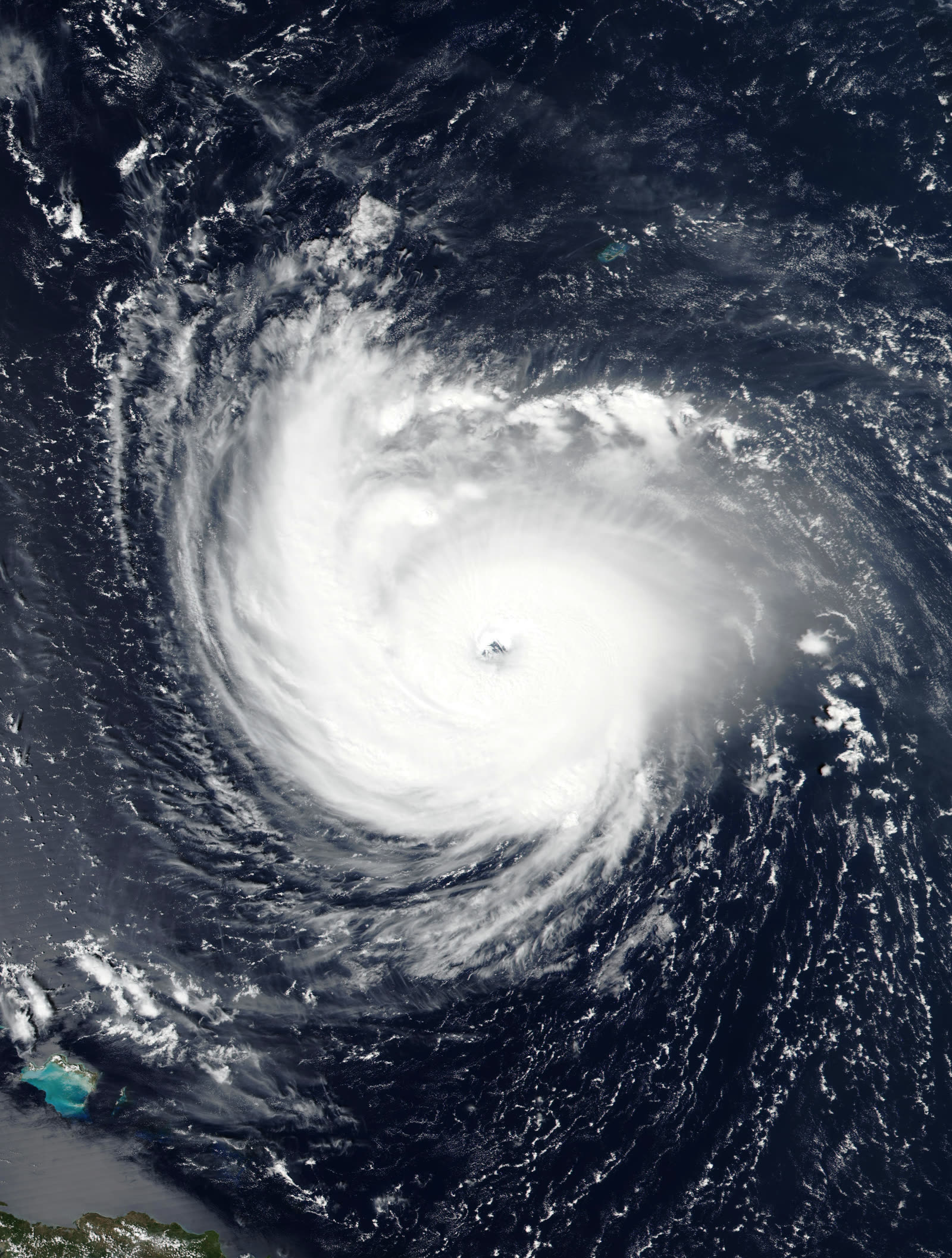
Florence at Category 4 strength over the open Atlantic, September 11, 2018, three days before landfall
STORM ARCHIVE / 2018 LANDFALL 34.2°N 77.8°W
CAT 1 AT LANDFALL PEAK CAT 4 SC · 2018 · 150 mph

Hurricane Florence

Landfall: Wrightsville Beach, NC · 2018-09-14. Insured wind losses stayed modest while uninsured flood damage ran toward $20B — and Nichols, SC drowned for the second time in 23 months, the NFIP repetitive-loss problem in one town

NASA (Worldview / MODIS)
AT LANDFALL
CAT 1
PEAK INTENSITY
CAT 4 · 150 mph
PRESSURE
958 mb (landfall)
STORM SURGE
up to 11 ft
DAMAGE
$24B
DEATHS
55
01 THE PATH

Where it hit, start to finish

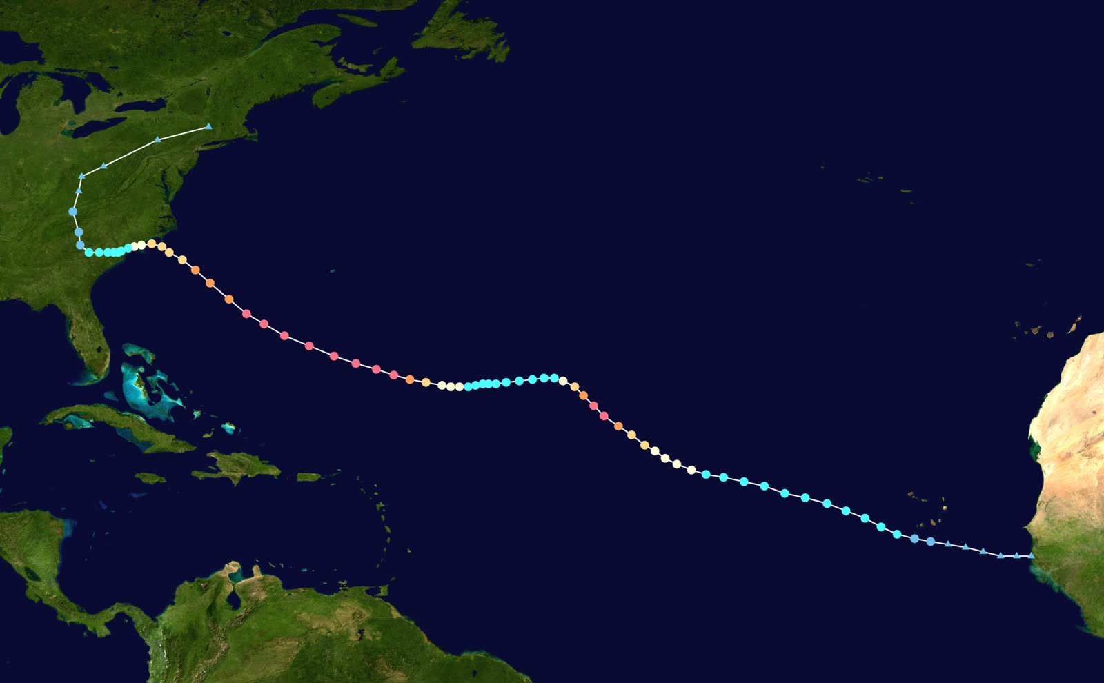
TRACK · HURRICANE FLORENCENOAA / NHC (best-track data)
Best track of Hurricane Florence, August 31 - September 17, 2018 — note the crawl at the NC/SC border
Open Atlantic
PEAK CAT 4 - 150 MPH

A Cape Verde storm from August 31, Florence peaked near 150 mph on September 11 while aimed at the Carolinas, triggering evacuation orders for more than a million people across NC, SC, and VA.

Offshore Carolinas
SHEAR WEAKENING, SIZE GROWING

Wind shear knocked Florence to Category 1 before landfall, but the wind field expanded and the forward speed collapsed — trading a wind disaster for a water one.

Wrightsville Beach, NC
LANDFALL - SEPT 14, 90 MPH, 958 MB

Landfall at 7:15 a.m. September 14. Surge up to 11 feet pushed up the Neuse River into New Bern, where hundreds were rescued from flooded homes. Wilmington lost power nearly citywide.

NC/SC border
THE CRAWL - 2-3 MPH

Florence crept southwest along the border for two days at walking pace, dropping 35.93 inches at Elizabethtown, NC and 23.63 inches at Loris, SC — tropical-cyclone rainfall records for both states.

Nichols / Conway, SC
RIVERS CRESTED FOR WEEKS

The Waccamaw, Lumber, Little Pee Dee, and Cape Fear rivers set record crests days after skies cleared. Nichols, SC — rebuilt after Matthew (2016) — flooded again; roughly 150 restored homes were inundated a second time in 23 months.

Carolinas inland
DISSIPATION AND THE BILL

Florence dissipated over the Northeast September 17-18. Toll: about 55 U.S. deaths, most by freshwater drowning, and $24 billion in damage — the majority uninsured flood loss.

02 THE RECORD IN IMAGES
ALL IMAGERY U.S. GOV / PUBLIC DOMAIN
SATELLITE NOAA / NESDIS (GOES-16)
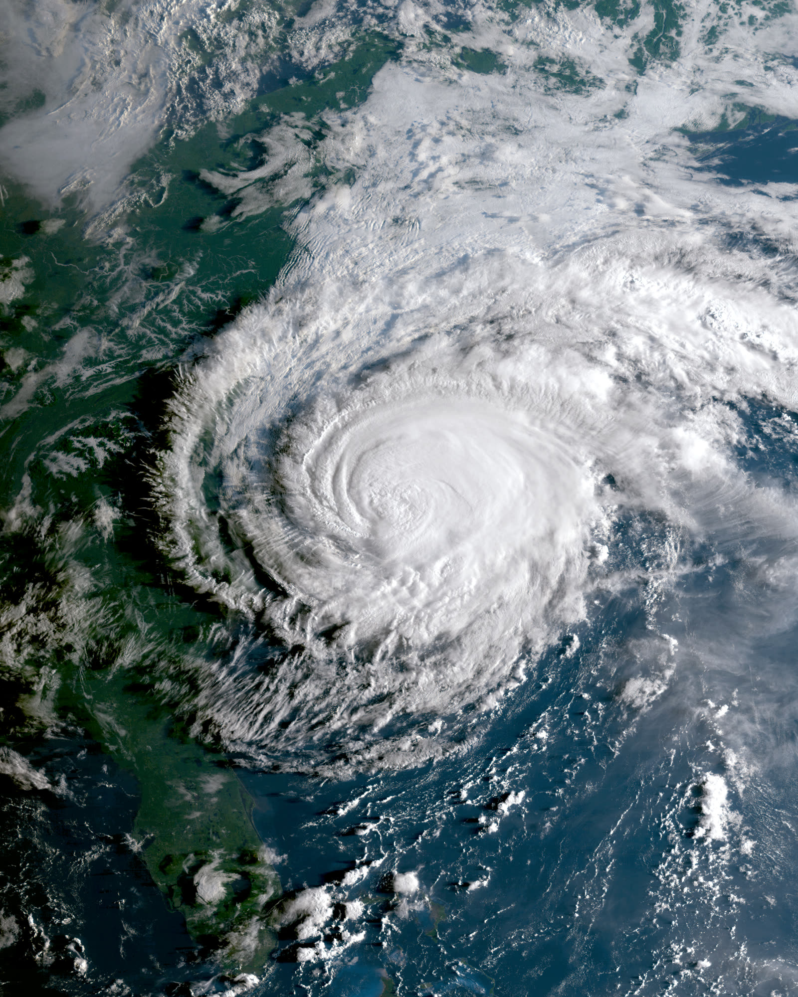
GOES-16 view of Florence coming ashore at Wrightsville Beach the morning of September 14, 2018
RADAR NOAA / NWS Wilmington
Wilmington radar animation of Florence's slow-motion landfall
MAP NOAA / NWS Eastern Region
Rainfall totals — 35.93 in at Elizabethtown, NC and 23.63 in at Loris, SC, both state tropical-cyclone records
FLOOD U.S. Coast Guard
Coast Guard Jayhawk crew evacuating residents from flooded Rocky Point, NC, September 16, 2018
AERIAL U.S. National Guard
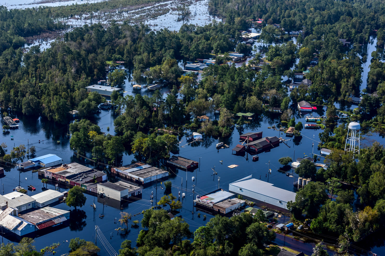
SC National Guard Black Hawk aerial of floodwater across the Nichols-Conway-Waccamaw corridor, SC

The storm

Florence left the Cape Verde islands August 31, 2018, and peaked at Category 4 — about 150 mph — on September 11 while pointed at the Carolinas. More than a million people were ordered to evacuate coastal North Carolina, South Carolina, and Virginia.

Wind shear then cut the storm to Category 1, but the dangerous trade was already underway: the wind field grew and the forward speed collapsed. Florence made landfall at Wrightsville Beach, North Carolina, on September 14 with 90 mph winds and a 958 mb pressure — then crawled southwest along the NC/SC border at 2-3 mph for two days.

The rain broke both states' tropical-cyclone records: 35.93 inches at Elizabethtown, NC and 23.63 inches at Loris, SC. Surge up to 11 feet had already flooded New Bern via the Neuse River. Then the rivers — Cape Fear, Lumber, Little Pee Dee, Waccamaw — rose toward record crests for a week afterward. About 55 people died, most by freshwater drowning. Damage reached $24 billion.
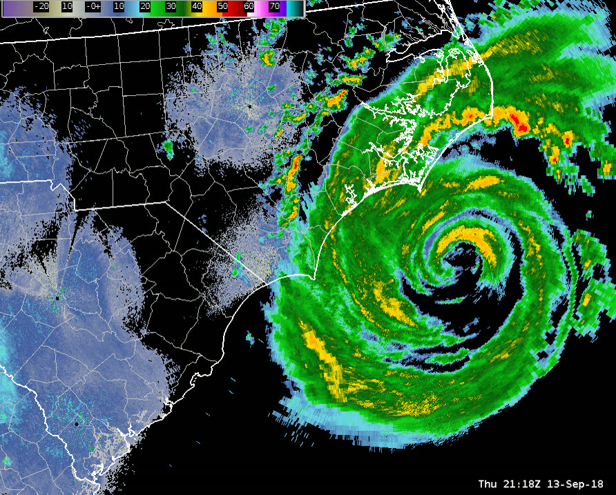
Wilmington radar animation of Florence's slow-motion landfall
Wilmington radar animation of Florence's slow-motion landfall NOAA / NWS Wilmington

The damage

At the coast, Florence was a survivable wind event: roof and siding damage, downed trees, near-total power loss around Wilmington. The catastrophe was water. New Bern's surge flooding required hundreds of rescues. Wilmington was cut off by floodwater for days. Whole counties of eastern North Carolina — Pender, Duplin, Jones — flooded as rivers left their banks.

South Carolina's disaster arrived on a delay. The Waccamaw at Conway crested at a record nearly two weeks after landfall. And Nichols, a Marion County farm town of about 400, flooded to the rooflines for the second time in 23 months: Hurricane Matthew (2016) had destroyed almost 90 percent of its 261 homes, and Florence inundated roughly 150 of the homes that had just been rebuilt. Homes, businesses, and the elementary school were abandoned after the second flood.
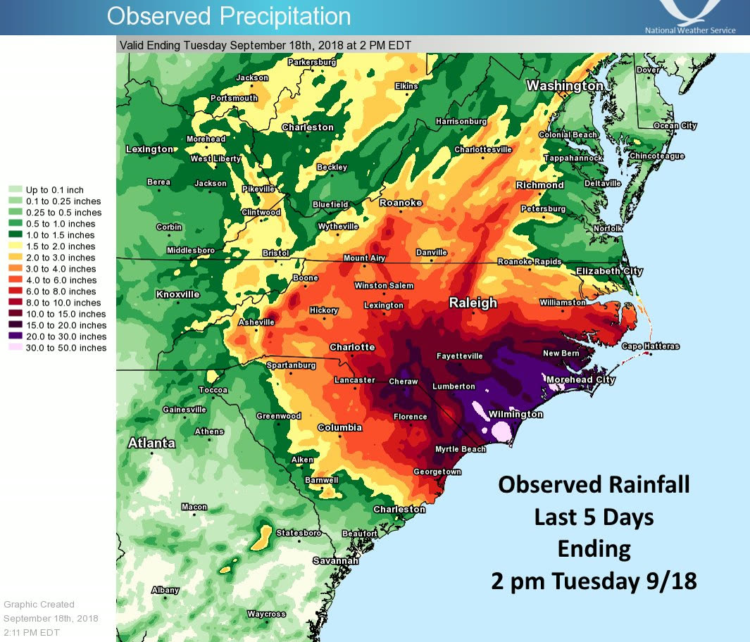
Rainfall totals — 35.93 in at Elizabethtown, NC and 23.63 in at Loris, SC, both state tropical-cyclone records
Rainfall totals — 35.93 in at Elizabethtown, NC and 23.63 in at Loris, SC, both state tropical-cyclone records NOAA / NWS Eastern Region

The insurance aftermath

Florence split cleanly along the wind/flood coverage line. Because landfall winds were Category 1, insured wind losses were moderate and carriers absorbed them without strain. The water was another story: estimates put uninsured flood losses near $20 billion — the bulk of the storm's total — because most of the flooded homes stood outside mapped high-risk zones and carried no flood policy. North Carolina had only about 134,000 NFIP policies in force statewide; roughly 445,000 covered NC, SC, and Virginia combined.

The NFIP ultimately performed for those who had it: more than 12,000 flood claims were filed within the first two weeks, and by September 2020 the program had paid $632.7 million to North Carolina policyholders. Homeowners carriers, meanwhile, generated the familiar denial patterns — flood exclusions applied to river water in living rooms, wind-driven-rain disputes where roofs leaked without visible breach, and depreciation and partial-roof-payment fights on wind claims.

Nichols made Florence a national exhibit for the NFIP's repetitive-loss problem: properties that flood, are rebuilt with claim payments and disaster aid in the same footprint, and flood again. Repetitive-loss properties are a small share of NFIP policies but a heavily outsized share of payouts, and Florence-after-Matthew put a face on the math. The policy responses that followed in the Carolinas — buyout and acquisition programs, elevation grants, South Carolina's disaster-recovery office relocation work in Nichols itself — all run on the same conclusion: the fourth flood claim costs more than the buyout.
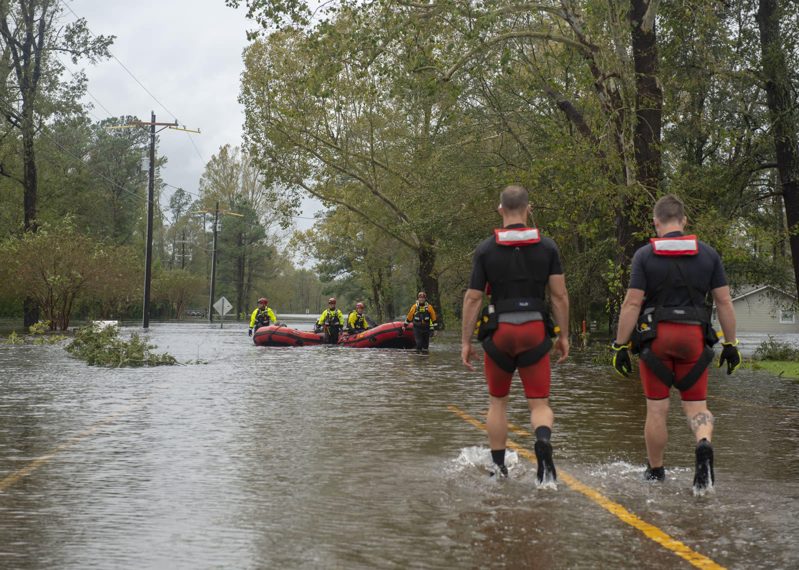
Coast Guard Jayhawk crew evacuating residents from flooded Rocky Point, NC, September 16, 2018
Coast Guard Jayhawk crew evacuating residents from flooded Rocky Point, NC, September 16, 2018 U.S. Coast Guard

What policyholders learned

  • The flood map is not the flood. Most Florence flood victims were outside Special Flood Hazard Areas and uninsured. Lender-required coverage is a floor set by mapping, not a measure of actual risk — inland and riverine homeowners learned they needed flood policies no one required.
  • Record crests arrive after the adjusters do. Rivers peaked up to two weeks post-landfall. Policyholders who re-documented damage at crest — not just at first inspection — captured the full loss.
  • Wind-driven rain became the fight where wind was "only" Cat 1. Carriers attributed interior water to excluded flood or seepage; policyholders who documented storm-created openings preserved wind coverage for interior damage.
  • Second-flood households faced 50%-rule and substantial-damage decisions. In Nichols, rebuilding twice in the same footprint triggered elevation and substantial-damage requirements. Owners who pursued buyouts or elevation grants exited the cycle; those who rebuilt in place re-entered it.
  • Two disasters, two claim files. Matthew-then-Florence households had to keep the storms' damage separate — prior-damage arguments cut payouts where documentation of the Matthew repairs was thin. Completion photos of any post-storm rebuild are claim evidence for the next storm.

Independent informational resource — not legal advice. Damage figures are nominal (not inflation-adjusted) unless noted. Insurance-law summaries are drafted for education; consult an attorney about your specific claim.

AT LANDFALL · HURRICANE FLORENCE · 2018
up to 11 ft
OF STORM SURGE · NEUSE RIVER / NEW BERN, NC
HURRICANELAW.PRO FIELD FOOTAGE
03 THE FULL RECORD

Every official record of Florence

Reports, imagery archives, flood data, and claims records — straight from the agencies.

OUR LAW FIRM PARTNER · HALVERSEN LAW
Florence claim denied?
CALL FL941-390-3233CALL SC843-542-0454FREE CLAIM REVIEW
RELATED GUIDES
HurricaneLaw.Pro HURRICANELAW.PRO

The independent policyholder resource for Florida & South Carolina — storm archive, coverage law, denials, bad faith, and the complete claims playbook. 51 storms · 46 carriers · 97 public-adjuster firms · 37 city guides.

▸ SEE THE FULL SITE MAP — EVERY PAGE →
STORM ALERTS SOURCED FROM NOAA / NHC
SOUTH CAROLINA
496 Bramson Court, Suite 100
Mount Pleasant, SC 29464
CALL OR TEXT
FLORIDA
Tampa, FL
CALL OR TEXT
CLAIMS 9
DENIALS 8
BAD FAITH 7
COVERAGE 12
COMMERCIAL 8
ROOFS 8
TREES 5
DIRECTORIES
STORMS 51
WEATHER
NEWS & SITE 19
STORM ARCHIVE, CITIES & NEWS
Most recent below. Every storm dossier, city resource, and article is on its hub (linked at each heading) or the grouped site map →. All 46 carriers and 97 public-adjuster firms are in the Directories column above.
STORM ARCHIVE · 51 →
Hurricane Debby 2024Hurricane Helene 2024Hurricane Milton 2024Hurricane Idalia 2023Hurricane Ian 2022Hurricane Nicole 2022Hurricane Ida 2021Hurricane Laura 2020 View all 51 →
FLORIDA CITY RESOURCES · 29 →
Boca RatonBradentonCape CoralClearwaterDaytona BeachDestinFort LauderdaleFort Myers View all 29 →
SOUTH CAROLINA CITY RESOURCES · 8 →
BeaufortCharlestonColumbiaFlorenceGreenvilleHilton Head IslandMount PleasantMyrtle Beach
NEWS & UPDATES · 19 →

HurricaneLaw.Pro is an independent informational resource, not a law firm. Coverage summaries, policy-language quotations, dollar figures, deadlines, and chart examples throughout this site are general information based on typical or standard policy forms and are illustrative only — they are not a quote, a guarantee of coverage, or a promise of any outcome. Every insurance policy is different: your own policy, endorsements, and state law control, so read your policy and confirm current statutes. Weather imagery courtesy of NOAA, the National Hurricane Center, and the National Weather Service. Legal services are provided by our law firm partner, Halversen Law. Nothing on this site is legal advice; consult an attorney about your specific claim.

PrivacyTermsDisclaimerAboutContact
© 2026 HURRICANELAW.PRO — ALL RIGHTS RESERVED 27.9°N 82.5°W · ATLANTIC BASIN MONITOR
OUR LAW FIRM PARTNER
Halversen Law LICENSED · FLORIDA & SOUTH CAROLINA

All legal matters on this site are referred to and handled by our law firm partner, Halversen Law, a licensed law firm in Florida and South Carolina. HurricaneLaw.Pro is an informational resource and is not itself a law firm.

FREE CASE REVIEW