PROPERTY-INSURANCE CLAIM HELP · FL & SC FL CITIESSC CITIESGUIDESTATESNEWSSITE MAPABOUT
HurricaneLaw.Pro HURRICANELAW.PRO
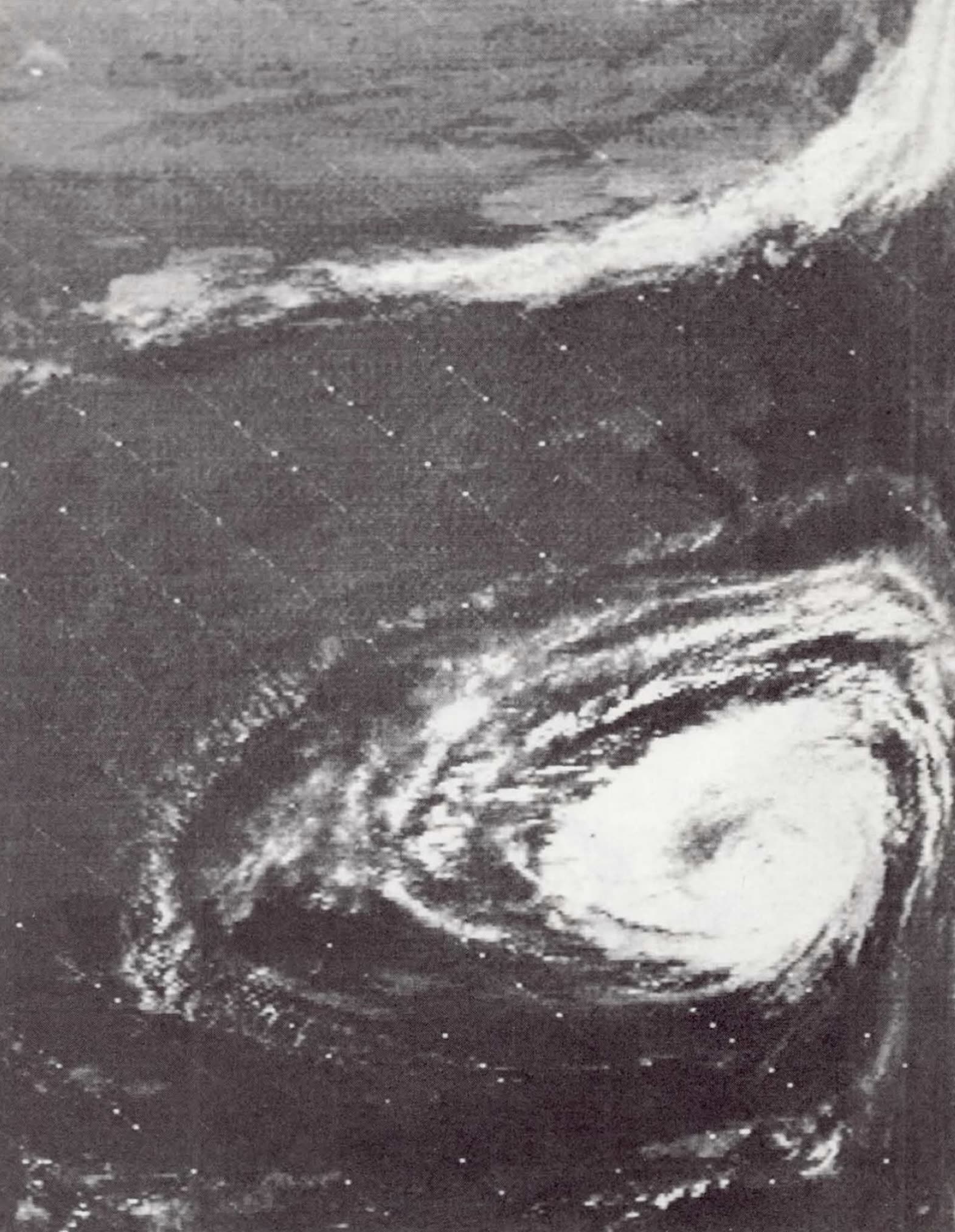
Dora approaching the Northeast Florida coast on September 9, 1964, imaged by NASA's Nimbus 1 - one of the first hurricanes photographed by satellite
STORM ARCHIVE / 1964 LANDFALL 29.9°N 81.3°W
2-3 AT LANDFALL PEAK CAT 3 FL · 1964 · 125 mph

Hurricane Dora

Landfall: St. Augustine, FL · 1964-09-10. The only hurricane on record to strike Northeast Florida head-on — the storm insurers still use to price Jacksonville's risk

NASA (Nimbus 1)
AT LANDFALL
2-3
PEAK INTENSITY
CAT 3 · 125 mph
PRESSURE
942 mb (peak)
STORM SURGE
~10 ft
DAMAGE
~$250M
DEATHS
5
01 THE PATH

Where it hit, start to finish

TRACK · HURRICANE DORANOAA / NHC (best-track data)
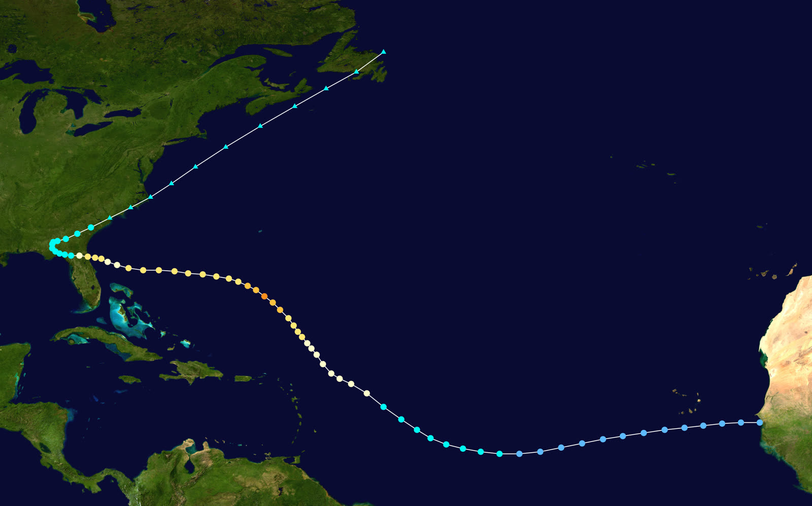
Best track of Hurricane Dora, August 28 - September 16, 1964 - a Cape Verde storm that ran due west into St. Augustine
Open Atlantic
CAPE VERDE PEAK - 130 MPH

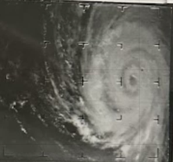
Dora formed near Senegal on August 28, 1964, and peaked over the open Atlantic on September 6 at Category 4-equivalent intensity: 130 mph winds, 942 mb.

Offshore Northeast FL
SLOW-MOTION APPROACH

Dora slowed to a crawl on final approach, battering the coast for more than a day before landfall. Tides ran up to 10 feet above mean sea level along the First Coast, driving severe beach erosion before the eye arrived.

St. Augustine, FL
LANDFALL - ONLY DIRECT NE-FL HIT ON RECORD

Landfall early September 10 with sustained winds near 110 mph; St. Augustine recorded winds to 125 mph. About $5 million damage in the city - the Castillo de San Marcos stood surrounded by floodwater and the Monson Motor Lodge took 30 inches of water.

Jacksonville / the Beaches
43 BEACH HOMES LOST

156,000 customers lost power, some for six days. At Jacksonville Beach, Atlantic Beach, and Ponte Vedra, surge and erosion destroyed 43 homes - roughly 20 swept into the sea - and wrecked bulkheads and a section of the St. Augustine Beach Pier.

Live Oak / Mayo, FL
INLAND FRESHWATER FLOOD

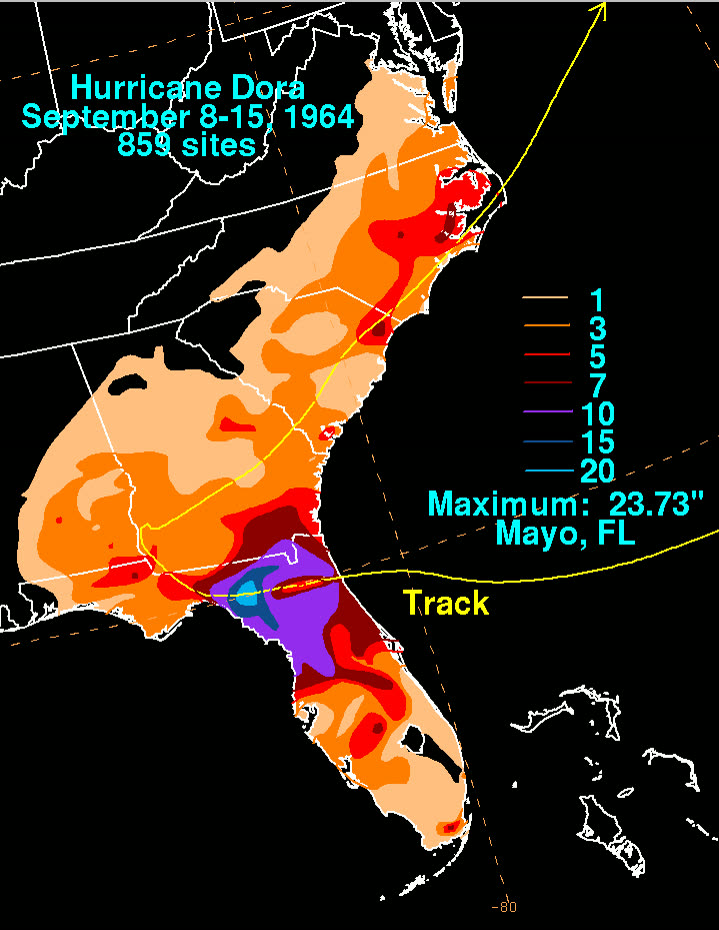
Dora stalled over North Florida and dropped 23.73 inches of rain at Mayo and 18.62 inches at Live Oak, flooding both towns; about 200 families evacuated around Cross City.

Coastal Georgia / South Carolina
EXIT AND DISSIPATION

Brunswick, GA saw an estimated 35-40% of dwellings damaged; Glynn County losses topped $3.6 million. Dora turned northeast and became extratropical over coastal South Carolina on September 13. Final toll: 5 deaths, roughly $250 million.

02 THE RECORD IN IMAGES
ALL IMAGERY U.S. GOV / PUBLIC DOMAIN
SATELLITE NOAA / NESDIS
Dora near Category 4-equivalent peak intensity (130 mph, 942 mb) over the open Atlantic, September 6, 1964
MAP NOAA / NHC (best-track data)
Detail of Dora's slow, erratic final approach into St. Augustine - the crawl that prolonged surge and erosion
DAMAGE State Archives of Florida
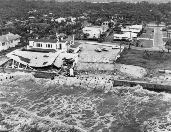
Storm-surge destruction at Atlantic Beach - 43 homes were lost along the Jacksonville beaches, about 20 swept to sea
AERIAL State Archives of Florida
Aerial view of erosion damage at Ponte Vedra Beach; 14 homes were destroyed between Vilano Beach and Ponte Vedra
FLOOD State Archives of Florida
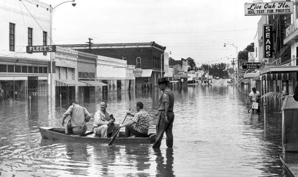
Boats in the streets of Live Oak, where Dora's rains put parts of town under deep freshwater flooding
MAP NOAA / WPC
Dora rainfall totals - 23.73 inches at Mayo, FL, as the storm stalled inland over North Florida

The storm

Dora was a Cape Verde hurricane, forming near Senegal on August 28, 1964, and crossing the entire Atlantic on a track that rarely threatens Florida's northeast coast. It peaked on September 6 at Category 4-equivalent strength — 130 mph, 942 mb — then curved due west toward the First Coast.

The approach was the problem. Dora slowed to a crawl offshore, pounding the Jacksonville–St. Augustine coastline for more than a day with onshore wind and tides up to 10 feet above mean sea level before the center ever arrived. Landfall came early on September 10 near St. Augustine, with sustained winds near 110 mph; St. Augustine itself recorded winds to 125 mph.

No other hurricane in the modern record has made direct landfall on Florida's Atlantic coast north of Stuart at that strength. Dora remains the only direct hurricane strike on Northeast Florida — the benchmark event for Jacksonville, the largest U.S. city that has taken exactly one hurricane hit.

After landfall Dora stalled over North Florida, dropped up to 23.73 inches of rain (Mayo), then drifted northeast and died over coastal South Carolina on September 13. Five deaths; damage estimates ran to roughly $250 million (1964 dollars).
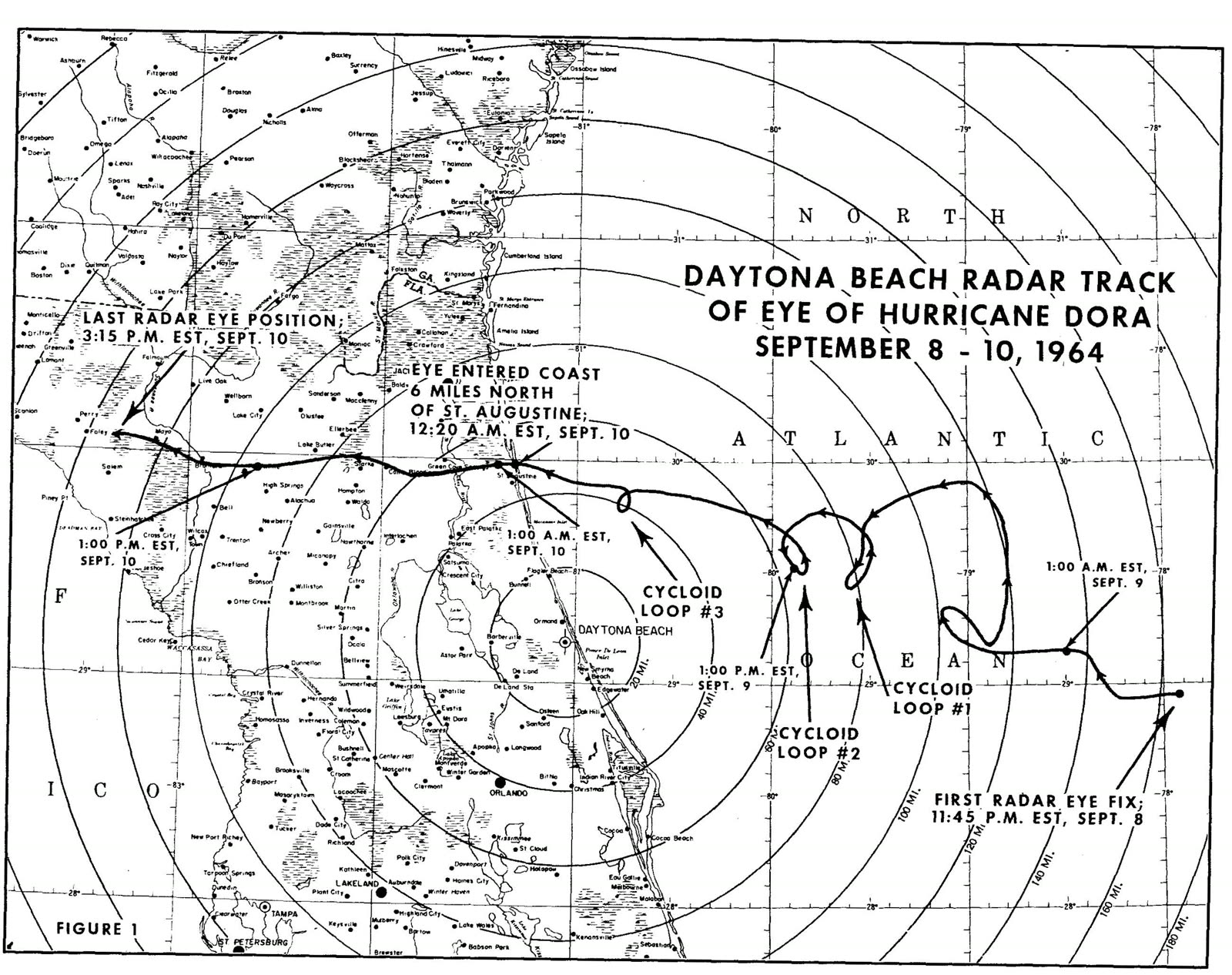
Detail of Dora's slow, erratic final approach into St. Augustine - the crawl that prolonged surge and erosion
Detail of Dora's slow, erratic final approach into St. Augustine - the crawl that prolonged surge and erosion NOAA / NHC (best-track data)

The damage

The coast took surge and erosion. Along the Jacksonville beaches — Jacksonville Beach, Atlantic Beach, Neptune Beach, Ponte Vedra — 43 homes were lost, about 20 swept to sea, with bulkheads destroyed along the strand. Fourteen homes went between Vilano Beach and Ponte Vedra alone. In St. Augustine, floodwater surrounded the Castillo de San Marcos, put 30 inches of water in the Monson Motor Lodge, and did about $5 million damage; part of the St. Augustine Beach Pier tore away.

Inland, wind and water spread wide: 156,000 Jacksonville-area customers lost power, some for six days. Across Florida, 74 dwellings were demolished and 9,374 damaged. Live Oak flooded from Dora's stalled rains; about 200 families evacuated near Cross City. In coastal Georgia, Brunswick saw an estimated 35–40% of dwellings damaged.

Storm-surge destruction at Atlantic Beach - 43 homes were lost along the Jacksonville beaches, about 20 swept to sea
Storm-surge destruction at Atlantic Beach - 43 homes were lost along the Jacksonville beaches, about 20 swept to sea State Archives of Florida

The insurance aftermath

Dora hit eleven years before flood insurance existed and decades before Florida's modern hurricane-claims machinery. There was no NFIP (created 1968), no hurricane deductible, no state catastrophe fund. Homeowners whose houses washed into the Atlantic had wind coverage that excluded "tidal wave" and rising water — the same wind-versus-water line that still decides Florida claims — and little recourse beyond it.

The gap was filled federally and personally. President Johnson toured the damage on September 11, 1964, and the area ultimately received about $8.2 million in federal disaster aid, including $1.8 million to rebuild St. Augustine's 6-mile seawall. Florida's disaster declaration, DR-176, was signed the day of landfall. The Red Cross flew typhoid serum into flooded inland towns. That pattern — uninsured coastal flood loss backstopped by ad-hoc federal relief — is exactly what Betsy repeated at 5x scale a year later, pushing Congress toward a national flood program.

Dora's longer insurance legacy is as a pricing benchmark. Because it is the only direct Northeast Florida landfall in the record, catastrophe models and reinsurers use a "Dora repeat" as the design scenario for Jacksonville — a metro of 1.7 million where most residents have never filed a hurricane claim. Duval County's low historical claim frequency keeps premiums below South Florida levels, but a repeat of Dora's track over today's beachfront exposure would produce losses out of proportion to that experience.
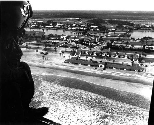
Aerial view of erosion damage at Ponte Vedra Beach; 14 homes were destroyed between Vilano Beach and Ponte Vedra
Aerial view of erosion damage at Ponte Vedra Beach; 14 homes were destroyed between Vilano Beach and Ponte Vedra State Archives of Florida

What policyholders learned

  • The wind/water line predates every modern policy fight. Dora-era homeowners learned that wind policies did not pay for homes lost to surge and erosion — the ancestor of today's surge-vs-flood denials.
  • Erosion and surge losses were effectively uninsurable in 1964. Beachfront owners recovered through federal aid, not insurance; flood coverage did not exist to buy.
  • "It doesn't happen here" is an exposure, not a fact. Jacksonville's single-landfall history keeps flood take-up and hurricane preparation low; Dora is the documented counterexample.
  • Slow storms multiply water claims. Dora's day-long crawl and stalled inland rains meant erosion, surge, and freshwater flooding dominated the loss — perils standard homeowners policies excluded then and exclude now.
  • Documented high-water history matters. St. Augustine's Dora flood lines remain reference points for elevation, floodplain mapping, and premium ratings six decades later.

Independent informational resource — not legal advice. Damage figures are nominal (not inflation-adjusted) unless noted. Insurance-law summaries are drafted for education; consult an attorney about your specific claim.

AT LANDFALL · HURRICANE DORA · 1964
~10 ft
OF STORM SURGE · JACKSONVILLE–ST. AUGUSTINE COAST
HURRICANELAW.PRO FIELD FOOTAGE
03 THE FULL RECORD

Every official record of Dora

Reports, imagery archives, flood data, and claims records — straight from the agencies.

OUR LAW FIRM PARTNER · HALVERSEN LAW
Dora claim denied?
CALL FL941-390-3233CALL SC843-542-0454FREE CLAIM REVIEW
RELATED GUIDES
HurricaneLaw.Pro HURRICANELAW.PRO

The independent policyholder resource for Florida & South Carolina — storm archive, coverage law, denials, bad faith, and the complete claims playbook. 51 storms · 46 carriers · 97 public-adjuster firms · 37 city guides.

▸ SEE THE FULL SITE MAP — EVERY PAGE →
STORM ALERTS SOURCED FROM NOAA / NHC
SOUTH CAROLINA
496 Bramson Court, Suite 100
Mount Pleasant, SC 29464
CALL OR TEXT
FLORIDA
Tampa, FL
CALL OR TEXT
CLAIMS 9
DENIALS 8
BAD FAITH 7
COVERAGE 12
COMMERCIAL 8
ROOFS 8
TREES 5
DIRECTORIES
STORMS 51
WEATHER
NEWS & SITE 19
STORM ARCHIVE, CITIES & NEWS
Most recent below. Every storm dossier, city resource, and article is on its hub (linked at each heading) or the grouped site map →. All 46 carriers and 97 public-adjuster firms are in the Directories column above.
STORM ARCHIVE · 51 →
Hurricane Debby 2024Hurricane Helene 2024Hurricane Milton 2024Hurricane Idalia 2023Hurricane Ian 2022Hurricane Nicole 2022Hurricane Ida 2021Hurricane Laura 2020 View all 51 →
FLORIDA CITY RESOURCES · 29 →
Boca RatonBradentonCape CoralClearwaterDaytona BeachDestinFort LauderdaleFort Myers View all 29 →
SOUTH CAROLINA CITY RESOURCES · 8 →
BeaufortCharlestonColumbiaFlorenceGreenvilleHilton Head IslandMount PleasantMyrtle Beach
NEWS & UPDATES · 19 →

HurricaneLaw.Pro is an independent informational resource, not a law firm. Coverage summaries, policy-language quotations, dollar figures, deadlines, and chart examples throughout this site are general information based on typical or standard policy forms and are illustrative only — they are not a quote, a guarantee of coverage, or a promise of any outcome. Every insurance policy is different: your own policy, endorsements, and state law control, so read your policy and confirm current statutes. Weather imagery courtesy of NOAA, the National Hurricane Center, and the National Weather Service. Legal services are provided by our law firm partner, Halversen Law. Nothing on this site is legal advice; consult an attorney about your specific claim.

PrivacyTermsDisclaimerAboutContact
© 2026 HURRICANELAW.PRO — ALL RIGHTS RESERVED 27.9°N 82.5°W · ATLANTIC BASIN MONITOR
OUR LAW FIRM PARTNER
Halversen Law LICENSED · FLORIDA & SOUTH CAROLINA

All legal matters on this site are referred to and handled by our law firm partner, Halversen Law, a licensed law firm in Florida and South Carolina. HurricaneLaw.Pro is an informational resource and is not itself a law firm.

FREE CASE REVIEW