
PROPERTY-INSURANCE CLAIM HELP · FL & SC FL CITIESSC CITIESGUIDESTATESNEWSSITE MAPABOUT
HurricaneLaw.Pro HURRICANELAW.PRO
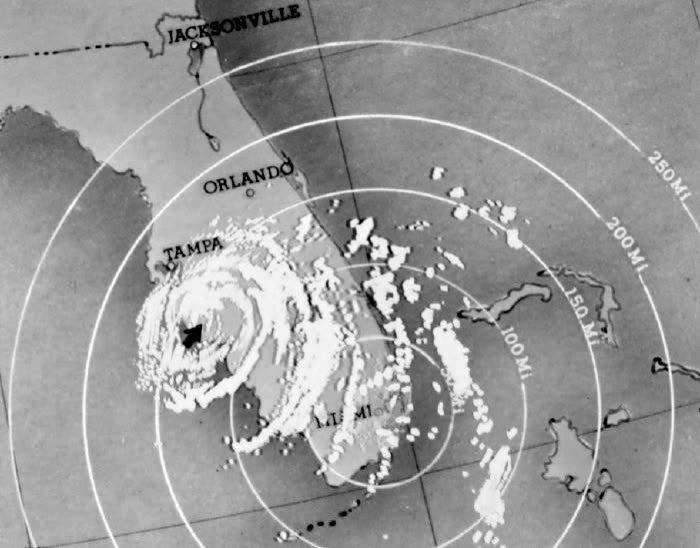
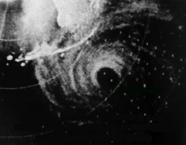
Radar image of Hurricane Donna's eye approaching its Florida landfall, September 1960
STORM ARCHIVE / 1960 LANDFALL 24.8°N 80.9°W
CAT 4 AT LANDFALL PEAK CAT 5 FL · 1960 · 160 mph

Hurricane Donna

Landfall: Middle Florida Keys → Naples, FL · 1960-09-10. The only hurricane on record to bring hurricane-force winds to Florida, the mid-Atlantic, and New England — and the catastrophe-ratemaking benchmark of its era

NOAA / NWS
AT LANDFALL
CAT 4
PEAK INTENSITY
CAT 5 · 160 mph
PRESSURE
930 mb
STORM SURGE
up to 13 ft
DAMAGE
~$387M US (1960)
DEATHS
50 (US)
01 THE PATH

Where it hit, start to finish

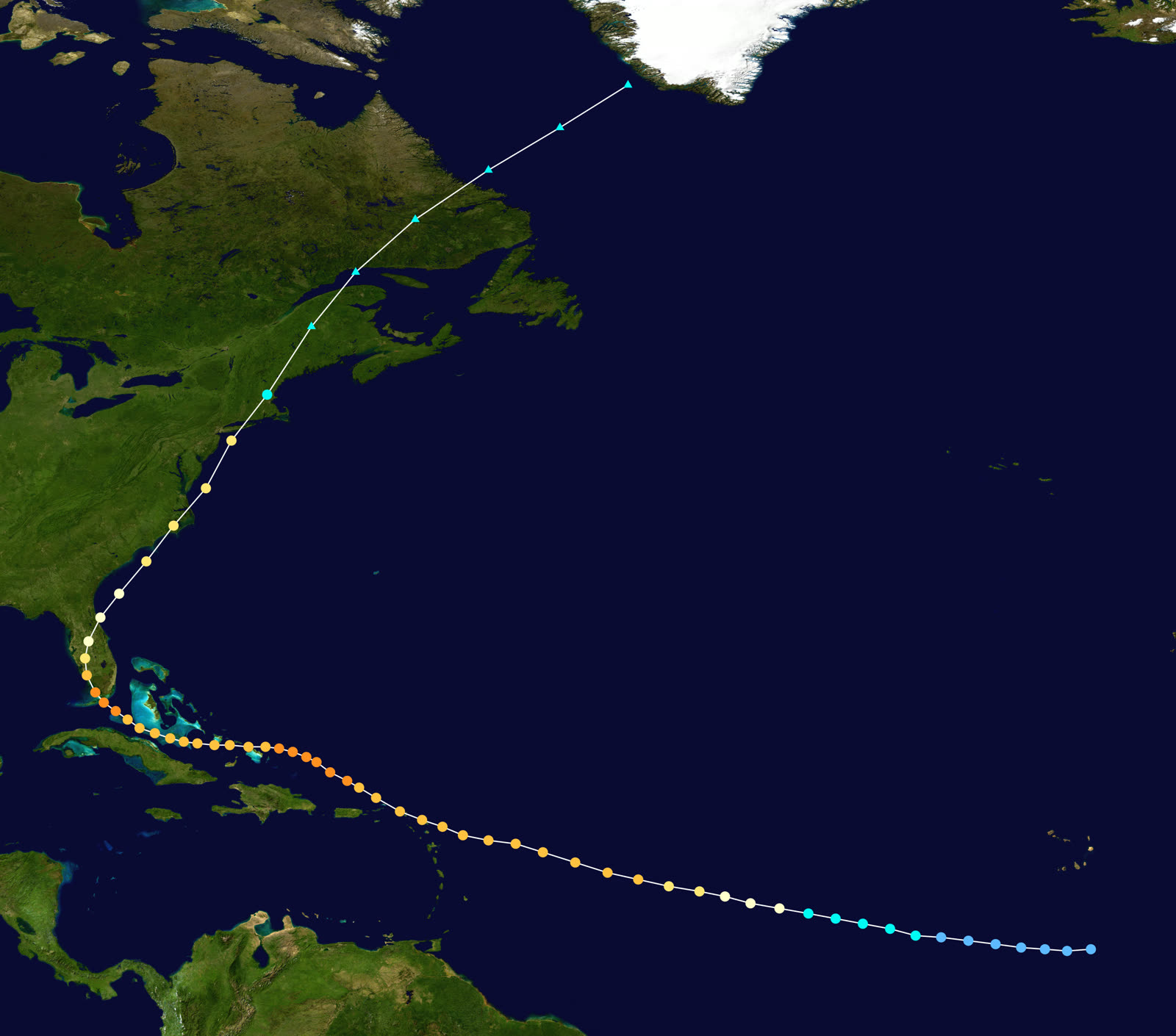
TRACK · HURRICANE DONNANOAA / NHC (best-track data)
Best track of Hurricane Donna, August 29 – September 13, 1960 — Cape Verde to New England
Leeward Islands / Puerto Rico
CARIBBEAN DEVASTATION

A Cape Verde storm from August 29, Donna crossed the northern Leewards September 4–5 as a Category 4; flooding in Puerto Rico killed over 100. Caribbean deaths exceeded 300.

Middle Florida Keys
CAT 4 LANDFALL — 13-FT SURGE

Landfall September 10 near the Marathon area at ~930 mb with 145-mph winds and surge to 13 ft. Between Marathon and Tavernier, 75% of buildings were damaged; the Overseas Highway was breached.

Naples / Fort Myers
SECOND FLORIDA LANDFALL

Donna curved northeast and struck near Naples September 11 with ~120-mph winds, wrecking waterfronts from Everglades City to Punta Gorda, then crossed the peninsula near Orlando. Florida: $350M damage, 14 dead.

Citrus & vegetable belt
AGRICULTURAL LOSSES

Donna destroyed about half of Florida's grapefruit crop, 10% of the total citrus crop, and nearly the entire avocado crop.

Topsail Beach, NC
THIRD U.S. LANDFALL

After re-strengthening over the Atlantic, Donna hit North Carolina September 12 at Category 2–3 strength, flooding the Outer Banks.

Long Island / New England
HURRICANE TO THE END

Donna crossed Long Island and New England September 12–13 still at hurricane force — the only storm on record to deliver hurricane winds to Florida, the mid-Atlantic, and New England — before going extratropical over Maine. U.S. toll: 50 dead, $387 million.

02 THE RECORD IN IMAGES
ALL IMAGERY U.S. GOV / PUBLIC DOMAIN
RADAR U.S. Navy
Navy reconnaissance radar fixes Donna's circular eye at 10 p.m. September 9, 1960, hours before the Keys landfall
DAMAGE State Archives of Florida (Florida Memory)
Rooftops torn open in Donna's wake — 75% of buildings between Marathon and Tavernier were damaged
MAP NOAA Central Library (U.S. Weather Bureau)
U.S. Weather Bureau surface map, September 10, 1960 — Donna at the Florida Keys
MAP NOAA / WPC
Donna's rainfall footprint along the entire U.S. East Coast
OTHER U.S. Navy
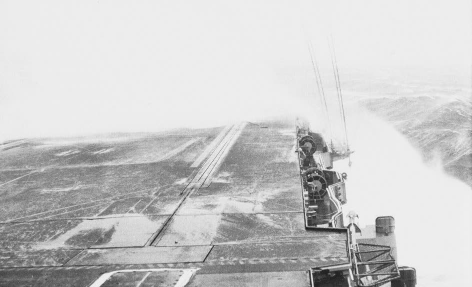
USS Franklin D. Roosevelt rides out Hurricane Donna at sea, 1960

The storm

Donna left the Cape Verde region on August 29, 1960, and stayed dangerous for two weeks across 6,000 miles — one of the great long-track hurricanes. It crossed the northern Leeward Islands September 4–5 as a Category 4, killed more than 100 in Puerto Rico's floods, and bore down on the Keys with peak winds that had reached 160 mph.

The first U.S. landfall came September 10 in the middle Keys near Marathon: about 930 mb, sustained winds near 145 mph, storm surge up to 13 feet across islands a few feet above sea level. Donna then curved northeast up the Gulf side and made a second Florida landfall near Naples on September 11 at about 120 mph, crossed the peninsula near Orlando, and re-intensified over the Atlantic. A third landfall hit Topsail Beach, North Carolina on September 12; that night Donna crossed Long Island and New England still at hurricane force, finally going extratropical over Maine on September 13. No other storm on record has delivered hurricane-force winds to Florida, the mid-Atlantic, and New England.
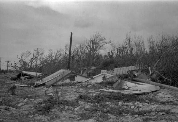
Rooftops torn open in Donna's wake — 75% of buildings between Marathon and Tavernier were damaged
Rooftops torn open in Donna's wake — 75% of buildings between Marathon and Tavernier were damaged State Archives of Florida (Florida Memory)

The damage

In the Keys, Donna damaged 75% of the buildings between Marathon and Tavernier, destroyed sections of the Overseas Highway, and cut the islands off for days. The Naples landfall wrecked the young Gulf-coast waterfront from Everglades City to Punta Gorda. Florida took roughly $350 million of Donna's $387 million U.S. damage total and 14 of its 50 U.S. deaths.

Agriculture absorbed a generational hit: about half the grapefruit crop, 10% of all citrus, and nearly the entire avocado crop were destroyed. North of Florida, Donna flooded the Outer Banks, pushed record tides into mid-Atlantic bays, and downed trees and power across Long Island and New England. Total damage including the Caribbean approached $900 million (1960); deaths across the storm's path exceeded 360.
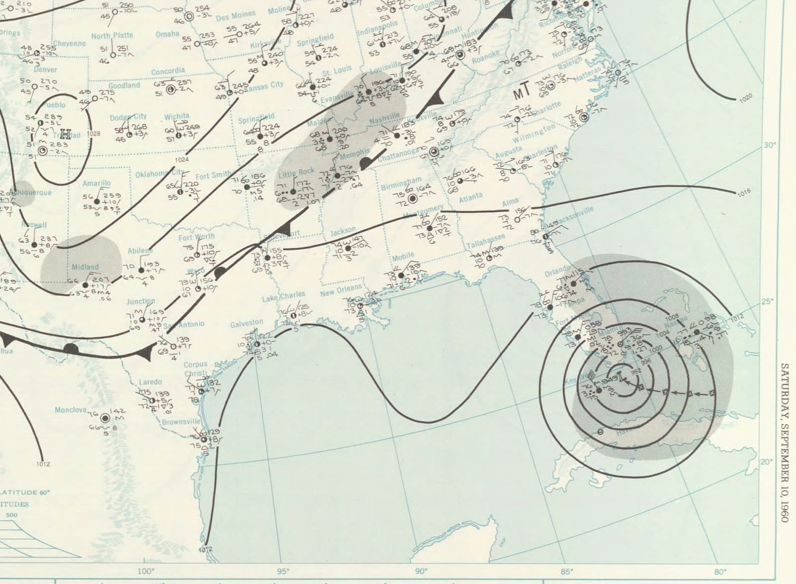
U.S. Weather Bureau surface map, September 10, 1960 — Donna at the Florida Keys
U.S. Weather Bureau surface map, September 10, 1960 — Donna at the Florida Keys NOAA Central Library (U.S. Weather Bureau)

The insurance aftermath

Donna was the costliest U.S. hurricane on record when it struck, and it hit an insurance market in transition. The packaged homeowners policy — bundling fire, wind, and liability — had been on the market only since the mid-1950s, and Donna delivered its first hurricane-catastrophe test: a single storm producing wind claims in nearly every East Coast state, from Keys fish camps to Long Island commuter suburbs. For carriers and the rating bureaus that set prices, Donna became the benchmark storm — the loss event catastrophe ratemaking and reinsurance treaties were measured against until Betsy (1965) and Camille (1969) reset the scale.

The uncovered half of the loss was familiar: surge. Keys and Naples water damage fell outside every standard policy, and no flood insurance existed to buy. Donna thus joined the chain of storms — 1926, 1928, 1947 — cited in the 1960s congressional studies that produced the National Flood Insurance Program in 1968. Federal disaster machinery was also young: Florida's Donna declaration (DR-106, September 13, 1960) was among the earliest major hurricane declarations under the 1950 Disaster Relief Act, pairing federal aid with what carriers wouldn't pay.

Donna's other legacy was informational. Radar at Key West and Miami and Navy reconnaissance tracked the eye continuously — the storm wallet's advisories gave South Florida days of warning, and the 14-death Florida toll against 145-mph winds validated the forecast-and-evacuate model that modern claims timelines assume.
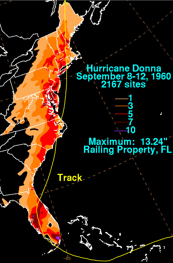
Donna's rainfall footprint along the entire U.S. East Coast
Donna's rainfall footprint along the entire U.S. East Coast NOAA / WPC

What policyholders learned

  • One storm can trigger claims in a dozen states. Donna stretched adjuster capacity coast-long; owners who documented early and filed fast settled first — the pattern every multi-state catastrophe has repeated since.
  • Surge was uninsurable in 1960; it's merely unpurchased now. Donna's water losses had no product behind them. Post-1968, the same loss is coverable — but only if a flood policy predates the storm.
  • Agricultural and landscaping losses fall outside the homeowners bundle. Groves, trees, and crops were Donna's biggest uncompensated Florida category; sublimits still make them claim orphans.
  • Benchmark storms set the price of everything after. Donna anchored 1960s wind ratemaking the way Andrew anchors it today; when a record storm hits, the next renewal cycle reflects it.
  • Warning time is documentation time. Donna's days of radar-tracked approach let owners secure and photograph property pre-landfall — the difference between a contested and a provable claim.

Independent informational resource — not legal advice. Damage figures are nominal (not inflation-adjusted) unless noted. Insurance-law summaries are drafted for education; consult an attorney about your specific claim.

AT LANDFALL · HURRICANE DONNA · 1960
up to 13 ft
OF STORM SURGE · FLORIDA KEYS
HURRICANELAW.PRO FIELD FOOTAGE
03 THE FULL RECORD

Every official record of Donna

Reports, imagery archives, flood data, and claims records — straight from the agencies.

OUR LAW FIRM PARTNER · HALVERSEN LAW
Donna claim denied?
CALL FL941-390-3233CALL SC843-542-0454FREE CLAIM REVIEW
RELATED GUIDES
HurricaneLaw.Pro HURRICANELAW.PRO

The independent policyholder resource for Florida & South Carolina — storm archive, coverage law, denials, bad faith, and the complete claims playbook. 51 storms · 46 carriers · 97 public-adjuster firms · 37 city guides.

▸ SEE THE FULL SITE MAP — EVERY PAGE →
STORM ALERTS SOURCED FROM NOAA / NHC
SOUTH CAROLINA
496 Bramson Court, Suite 100
Mount Pleasant, SC 29464
CALL OR TEXT
FLORIDA
Tampa, FL
CALL OR TEXT
CLAIMS 9
DENIALS 8
BAD FAITH 7
COVERAGE 12
COMMERCIAL 8
ROOFS 8
TREES 5
DIRECTORIES
STORMS 51
WEATHER
NEWS & SITE 19
STORM ARCHIVE, CITIES & NEWS
Most recent below. Every storm dossier, city resource, and article is on its hub (linked at each heading) or the grouped site map →. All 46 carriers and 97 public-adjuster firms are in the Directories column above.
STORM ARCHIVE · 51 →
Hurricane Debby 2024Hurricane Helene 2024Hurricane Milton 2024Hurricane Idalia 2023Hurricane Ian 2022Hurricane Nicole 2022Hurricane Ida 2021Hurricane Laura 2020 View all 51 →
FLORIDA CITY RESOURCES · 29 →
Boca RatonBradentonCape CoralClearwaterDaytona BeachDestinFort LauderdaleFort Myers View all 29 →
SOUTH CAROLINA CITY RESOURCES · 8 →
BeaufortCharlestonColumbiaFlorenceGreenvilleHilton Head IslandMount PleasantMyrtle Beach
NEWS & UPDATES · 19 →

HurricaneLaw.Pro is an independent informational resource, not a law firm. Coverage summaries, policy-language quotations, dollar figures, deadlines, and chart examples throughout this site are general information based on typical or standard policy forms and are illustrative only — they are not a quote, a guarantee of coverage, or a promise of any outcome. Every insurance policy is different: your own policy, endorsements, and state law control, so read your policy and confirm current statutes. Weather imagery courtesy of NOAA, the National Hurricane Center, and the National Weather Service. Legal services are provided by our law firm partner, Halversen Law. Nothing on this site is legal advice; consult an attorney about your specific claim.

PrivacyTermsDisclaimerAboutContact
© 2026 HURRICANELAW.PRO — ALL RIGHTS RESERVED 27.9°N 82.5°W · ATLANTIC BASIN MONITOR
OUR LAW FIRM PARTNER
Halversen Law LICENSED · FLORIDA & SOUTH CAROLINA

All legal matters on this site are referred to and handled by our law firm partner, Halversen Law, a licensed law firm in Florida and South Carolina. HurricaneLaw.Pro is an informational resource and is not itself a law firm.

FREE CASE REVIEW