
PROPERTY-INSURANCE CLAIM HELP · FL & SC FL CITIESSC CITIESGUIDESTATESNEWSSITE MAPABOUT
HurricaneLaw.Pro HURRICANELAW.PRO
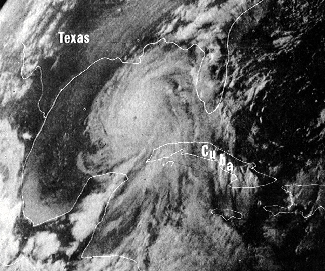
Camille near peak intensity in the Gulf of Mexico, satellite view, August 16, 1969
STORM ARCHIVE / 1969 LANDFALL 30.3°N 89.3°W
CAT 5 US · 1969 · 175 mph

Hurricane Camille

Landfall: Near Waveland / Pass Christian, MS · 1969-08-17. Camille's surge denials produced the Mississippi wind-vs-water case law — Byrne, Lunday, Grace — still cited for and against policyholders decades later after Katrina

NOAA / NCDC (ESSA satellite)
AT LANDFALL
CAT 5
PEAK WIND
175 mph
PRESSURE
900 mb
STORM SURGE
24.6 ft
DAMAGE
$1.42B
DEATHS
259
01 THE PATH

Where it hit, start to finish

TRACK · HURRICANE CAMILLENOAA (HURDAT best-track data)
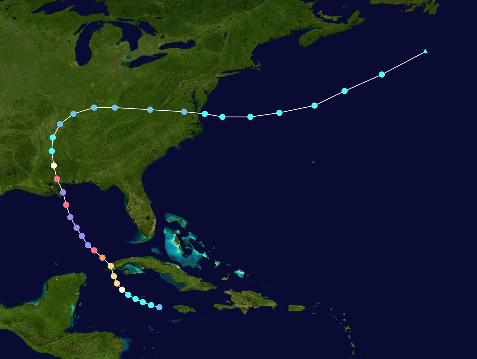
Best track of Hurricane Camille, August 14-22, 1969 — Category 5 at the Mississippi coast, then record floods in Virginia
Western Cuba
FIRST LANDFALL

Camille formed near the Cayman Islands August 14 and crossed western Cuba August 15 as a Category 2-3, then entered the Gulf.

Gulf of Mexico
RAPID INTENSIFICATION TO 175 MPH

Over two days Camille deepened explosively. Reconnaissance near the mouth of the Mississippi measured a central pressure of 900 mb — landfall intensity was set at 175 mph in NOAA's 2014 reanalysis, one of only four Category 5 U.S. landfalls on record.

Waveland / Bay St. Louis / Pass Christian, MS
CAT 5 LANDFALL - 24.6 FT SURGE

Landfall near midnight August 17-18. The surge peaked at 24.6 feet at Pass Christian — the U.S. record until Katrina in 2005. Beachfront blocks from Waveland to Biloxi were scraped to slab; 143 died on the Gulf Coast.

Mississippi interior
INLAND DECAY

Camille weakened quickly inland over Mississippi and Tennessee August 18-19, seemingly finished as a killer.

Nelson County, VA
27 INCHES OVERNIGHT - 113 DEAD

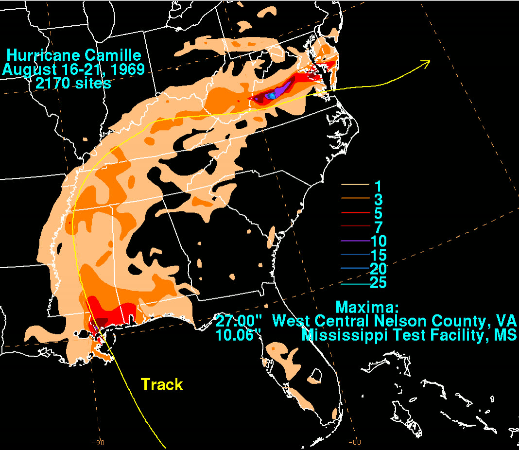
On the night of August 19-20 Camille's remnants stalled against the Blue Ridge and dropped up to 27 inches of rain in roughly eight hours. Flash floods and debris slides killed 113 people in Virginia, most in Nelson County, before the storm exited to sea.

02 THE RECORD IN IMAGES
ALL IMAGERY U.S. GOV / PUBLIC DOMAIN
RADAR NOAA / NWS
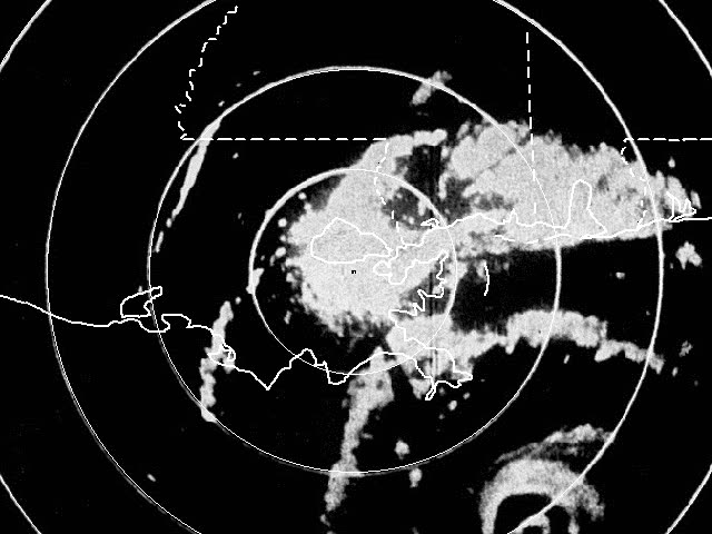
Radar loop of Camille's eye approaching the Mississippi coast, August 17, 1969
OTHER NOAA Photo Library
The Richelieu Apartments, Pass Christian, before Camille — a three-story block near the beachfront
DAMAGE NOAA Photo Library
The Richelieu Apartments after the 24.6-ft surge — slab-clean destruction that framed the wind-vs-water fight
DAMAGE NOAA / Coast and Geodetic Survey
U.S. Highway 90 along the Mississippi beachfront, buckled and buried by surge
MAP NOAA / WPC (David Roth)
Rainfall footprint — the 27-inch overnight deluge in Nelson County, VA killed 113 people

The storm

Camille formed near the Cayman Islands on August 14, 1969, crossed western Cuba, and intensified explosively over the Gulf. Reconnaissance aircraft near the mouth of the Mississippi measured a central pressure of 900 mb. NOAA's 2014 reanalysis set landfall intensity at 175 mph — one of only four Category 5 landfalls in U.S. records.

Camille struck the Mississippi coast near Waveland and Bay St. Louis around midnight on August 17-18. The storm surge peaked at 24.6 feet at Pass Christian, the U.S. record until Katrina broke it in 2005 on the same coast. The Gulf Coast counted 143 dead.

The storm was not finished. Its remnants crossed Mississippi and Tennessee, then stalled against Virginia's Blue Ridge on the night of August 19-20 and dropped up to 27 inches of rain in about eight hours. Flash floods and debris slides killed 113 people, most in Nelson County. Camille's total toll: 259 dead and $1.42 billion in damage.
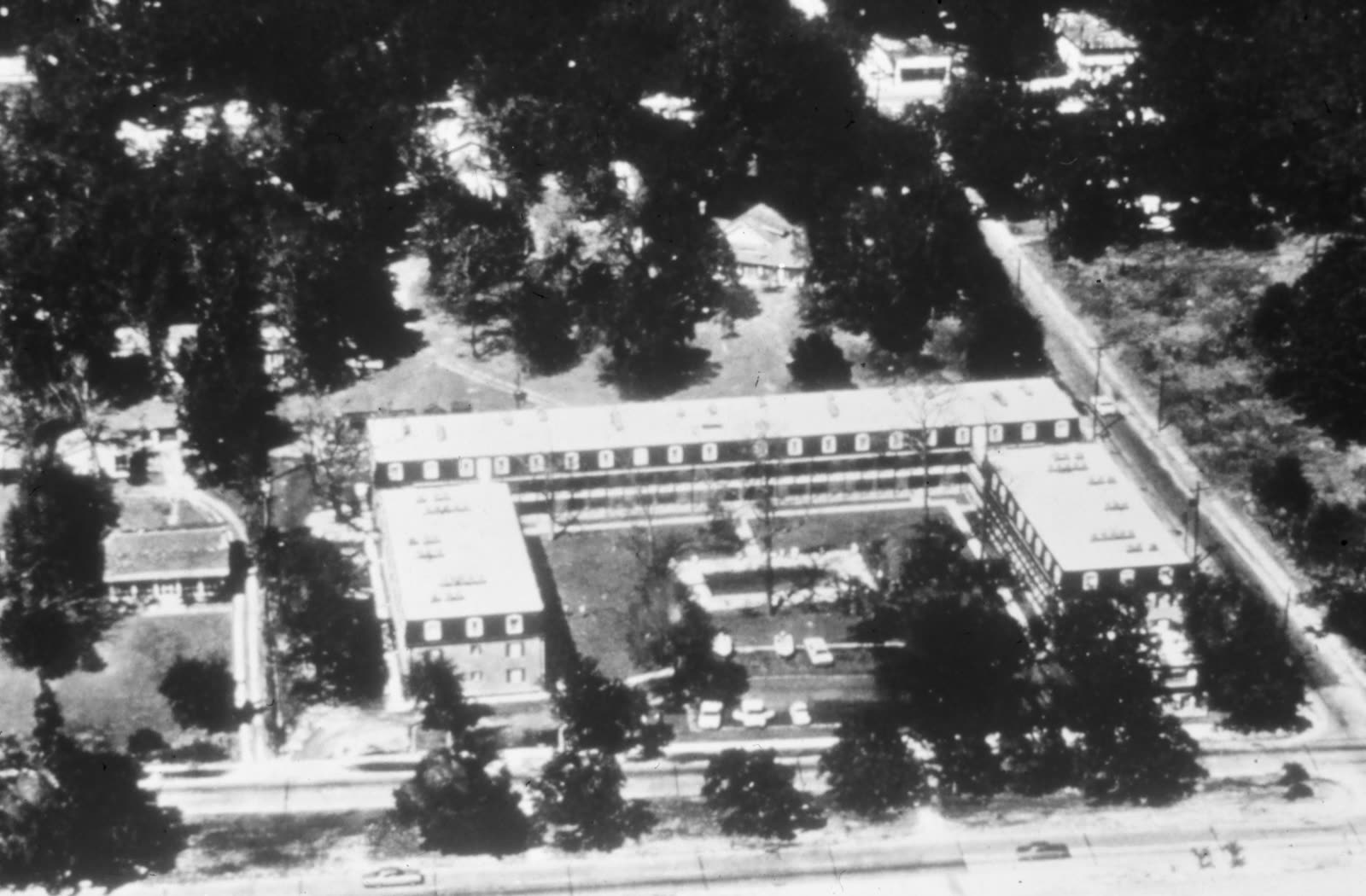
The Richelieu Apartments, Pass Christian, before Camille — a three-story block near the beachfront
The Richelieu Apartments, Pass Christian, before Camille — a three-story block near the beachfront NOAA Photo Library

The damage

From Waveland through Pass Christian, Long Beach, and Gulfport, the first several blocks inland were destroyed to the slab. U.S. Highway 90 buckled under the surge; three oceangoing ships were driven aground. The Richelieu Apartments in Pass Christian — a three-story block near the beach where several residents stayed — were demolished so completely that the before/after photographs became the storm's emblem. Roughly 5,600 homes were destroyed and tens of thousands damaged across the coast.

In Virginia, the damage was water alone: whole hillsides liquefied, roads and bridges disappeared, and communities along the Rockfish and Tye rivers were cut off for days.
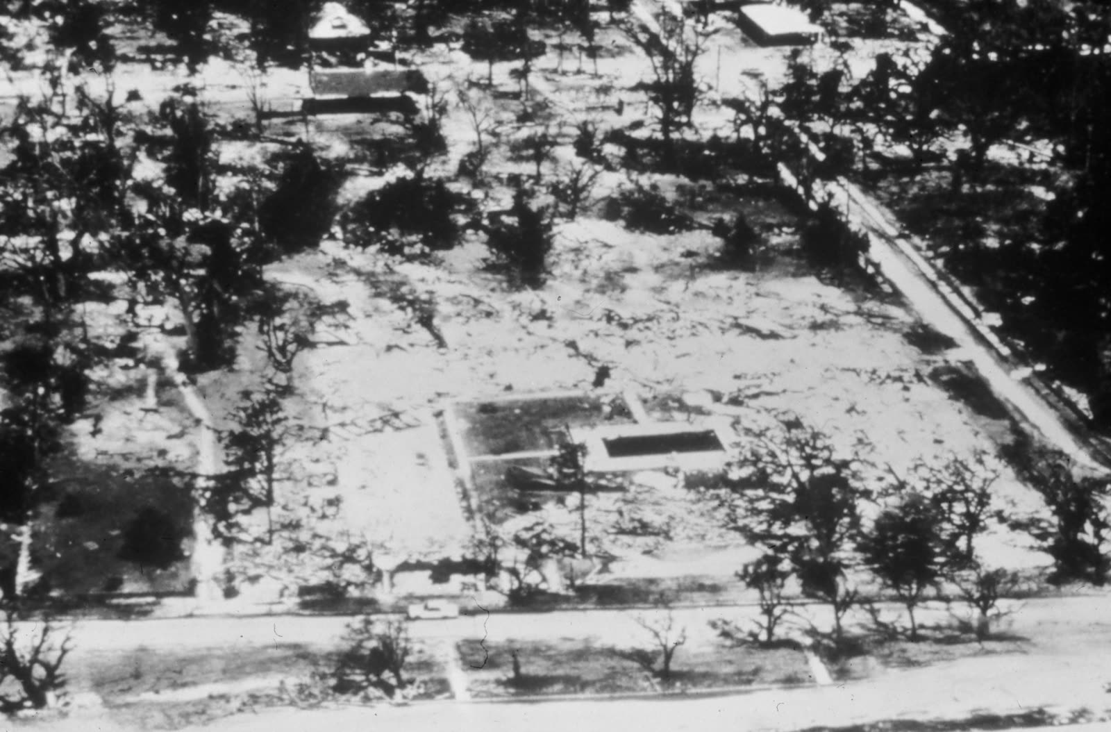
The Richelieu Apartments after the 24.6-ft surge — slab-clean destruction that framed the wind-vs-water fight
The Richelieu Apartments after the 24.6-ft surge — slab-clean destruction that framed the wind-vs-water fight NOAA Photo Library

The insurance aftermath

Camille is where the modern wind-versus-water fight took shape. Homeowners policies of 1969 covered wind but excluded "flood, surface water, waves, tidal water or tidal wave." With everything near the beach reduced to slab, carriers attributed losses to excluded surge; policyholders argued wind — blowing at Category 5 strength for hours before the surge peaked — had destroyed or breached their homes first. Thousands of disputes followed, and Mississippi's courts built the framework that governed them.

In Commercial Union Insurance Co. v. Byrne (Miss. 1971), a jury was permitted to find that wind and wind-driven rain entering through storm-created openings had damaged the house before tidal water arrived — watermarks on the walls notwithstanding. In Lunday v. Lititz Mutual Insurance Co. (Miss. 1973) and Grace v. Lititz Mutual (Miss. 1974), the court allocated the burden: the policyholder proves a covered windstorm loss; the insurer bears the burden of proving how much of the loss its water exclusion removes. That burden allocation was — and remains — one of the most policyholder-favorable causation rules in the country.

The carriers responded in the drafting room. In the years after Camille, water exclusions were rewritten and, eventually, anti-concurrent-causation clauses appeared — language excluding water damage even when wind contributed "in any sequence" to the loss. When Katrina razed the same coastline in 2005, both sides reached back to Camille: policyholders cited Byrne, Lunday, and Grace for the insurer's burden; carriers argued the new clauses displaced the Camille-era default, and in Leonard v. Nationwide (5th Cir. 2007) the anti-concurrent language was upheld. Camille also gave the year-old National Flood Insurance Program its first major-catastrophe argument: almost no one on the Mississippi coast held flood coverage in 1969, and participation grew through the 1970s.
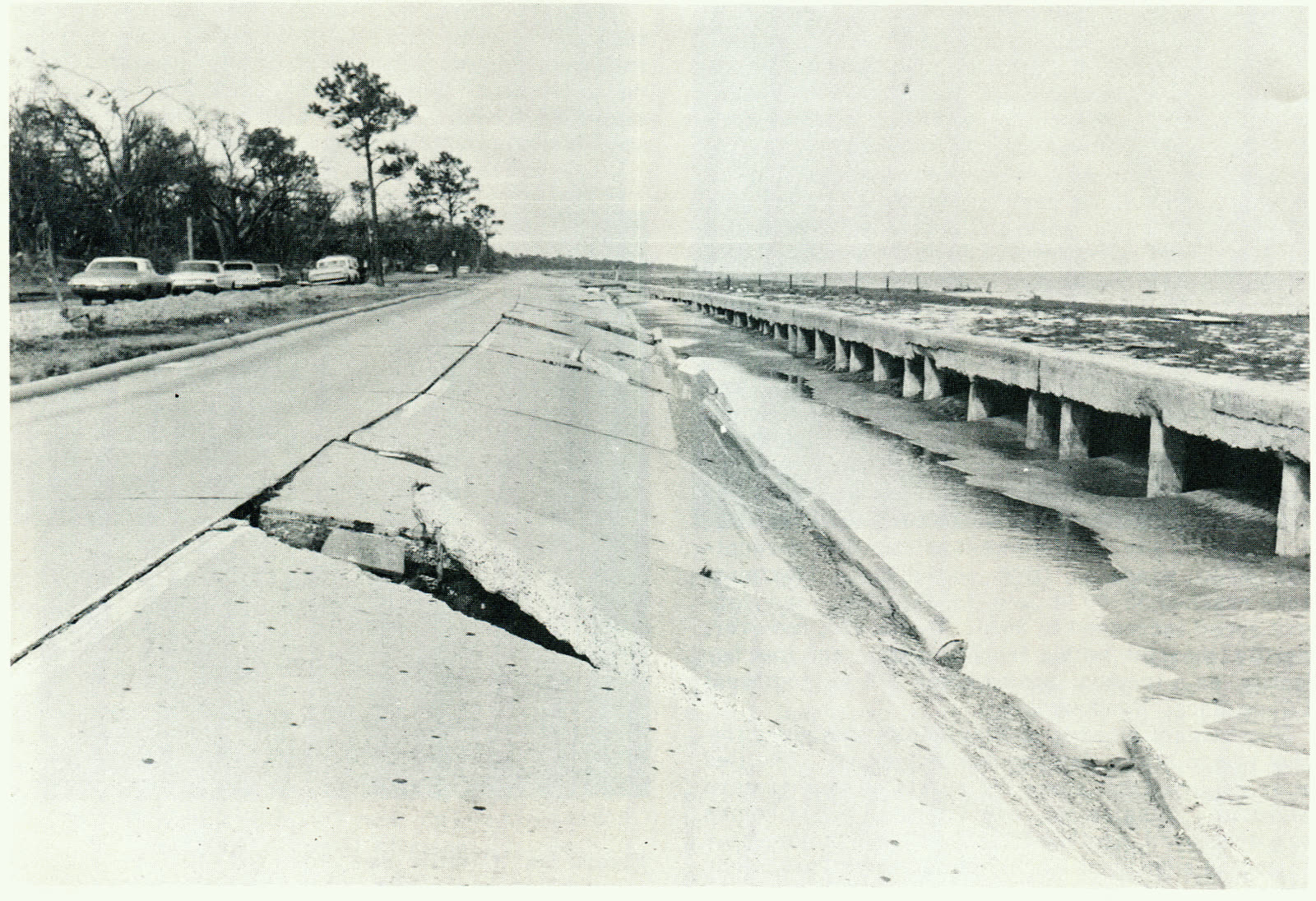
U.S. Highway 90 along the Mississippi beachfront, buckled and buried by surge
U.S. Highway 90 along the Mississippi beachfront, buckled and buried by surge NOAA / Coast and Geodetic Survey

What policyholders learned

  • Slab cases turn on sequence. Where nothing remains, the question is what failed first. Camille policyholders who could show wind damage preceding inundation — debris patterns, timing evidence, neighbor testimony — recovered; pure-surge presentations did not.
  • The insurer bears the allocation burden (in Camille's line of cases). Under Lunday and Grace, once a windstorm loss is shown, the carrier must prove what portion its water exclusion removes. Policyholders who forced that burden onto the insurer fared better than those who accepted a lump denial.
  • Watermarks are not the whole story. Byrne held a jury could find wind-driven rain did the damage before the water rose. Interior damage above the waterline became key evidence.
  • Exclusion language evolves after every catastrophe. The "in any sequence" anti-concurrent clause is Camille's drafting legacy. Reading the current water exclusion — not the one from the last storm — is the first step in any surge-zone claim.
  • Flood coverage was the missing instrument. The NFIP existed in 1969 and almost nobody had it. Every Camille-to-Katrina retrospective repeats the same conclusion: the wind/water fight shrinks when both policies exist.

Independent informational resource — not legal advice. Damage figures are nominal (not inflation-adjusted) unless noted. Insurance-law summaries are drafted for education; consult an attorney about your specific claim.

AT LANDFALL · HURRICANE CAMILLE · 1969
24.6 ft — the U.S. record until Katrina
OF STORM SURGE · PASS CHRISTIAN
HURRICANELAW.PRO FIELD FOOTAGE
03 THE FULL RECORD

Every official record of Camille

Reports, imagery archives, flood data, and claims records — straight from the agencies.

OUR LAW FIRM PARTNER · HALVERSEN LAW
Camille claim denied?
CALL FL941-390-3233CALL SC843-542-0454FREE CLAIM REVIEW
RELATED GUIDES
HurricaneLaw.Pro HURRICANELAW.PRO

The independent policyholder resource for Florida & South Carolina — storm archive, coverage law, denials, bad faith, and the complete claims playbook. 51 storms · 46 carriers · 97 public-adjuster firms · 37 city guides.

▸ SEE THE FULL SITE MAP — EVERY PAGE →
STORM ALERTS SOURCED FROM NOAA / NHC
SOUTH CAROLINA
496 Bramson Court, Suite 100
Mount Pleasant, SC 29464
CALL OR TEXT
FLORIDA
Tampa, FL
CALL OR TEXT
CLAIMS 9
DENIALS 8
BAD FAITH 7
COVERAGE 12
COMMERCIAL 8
ROOFS 8
TREES 5
DIRECTORIES
STORMS 51
WEATHER
NEWS & SITE 19
STORM ARCHIVE, CITIES & NEWS
Most recent below. Every storm dossier, city resource, and article is on its hub (linked at each heading) or the grouped site map →. All 46 carriers and 97 public-adjuster firms are in the Directories column above.
STORM ARCHIVE · 51 →
Hurricane Debby 2024Hurricane Helene 2024Hurricane Milton 2024Hurricane Idalia 2023Hurricane Ian 2022Hurricane Nicole 2022Hurricane Ida 2021Hurricane Laura 2020 View all 51 →
FLORIDA CITY RESOURCES · 29 →
Boca RatonBradentonCape CoralClearwaterDaytona BeachDestinFort LauderdaleFort Myers View all 29 →
SOUTH CAROLINA CITY RESOURCES · 8 →
BeaufortCharlestonColumbiaFlorenceGreenvilleHilton Head IslandMount PleasantMyrtle Beach
NEWS & UPDATES · 19 →

HurricaneLaw.Pro is an independent informational resource, not a law firm. Coverage summaries, policy-language quotations, dollar figures, deadlines, and chart examples throughout this site are general information based on typical or standard policy forms and are illustrative only — they are not a quote, a guarantee of coverage, or a promise of any outcome. Every insurance policy is different: your own policy, endorsements, and state law control, so read your policy and confirm current statutes. Weather imagery courtesy of NOAA, the National Hurricane Center, and the National Weather Service. Legal services are provided by our law firm partner, Halversen Law. Nothing on this site is legal advice; consult an attorney about your specific claim.

PrivacyTermsDisclaimerAboutContact
© 2026 HURRICANELAW.PRO — ALL RIGHTS RESERVED 27.9°N 82.5°W · ATLANTIC BASIN MONITOR
OUR LAW FIRM PARTNER
Halversen Law LICENSED · FLORIDA & SOUTH CAROLINA

All legal matters on this site are referred to and handled by our law firm partner, Halversen Law, a licensed law firm in Florida and South Carolina. HurricaneLaw.Pro is an informational resource and is not itself a law firm.

FREE CASE REVIEW