

PROPERTY-INSURANCE CLAIM HELP · FL & SC FL CITIESSC CITIESGUIDESTATESNEWSSITE MAPABOUT
HurricaneLaw.Pro HURRICANELAW.PRO
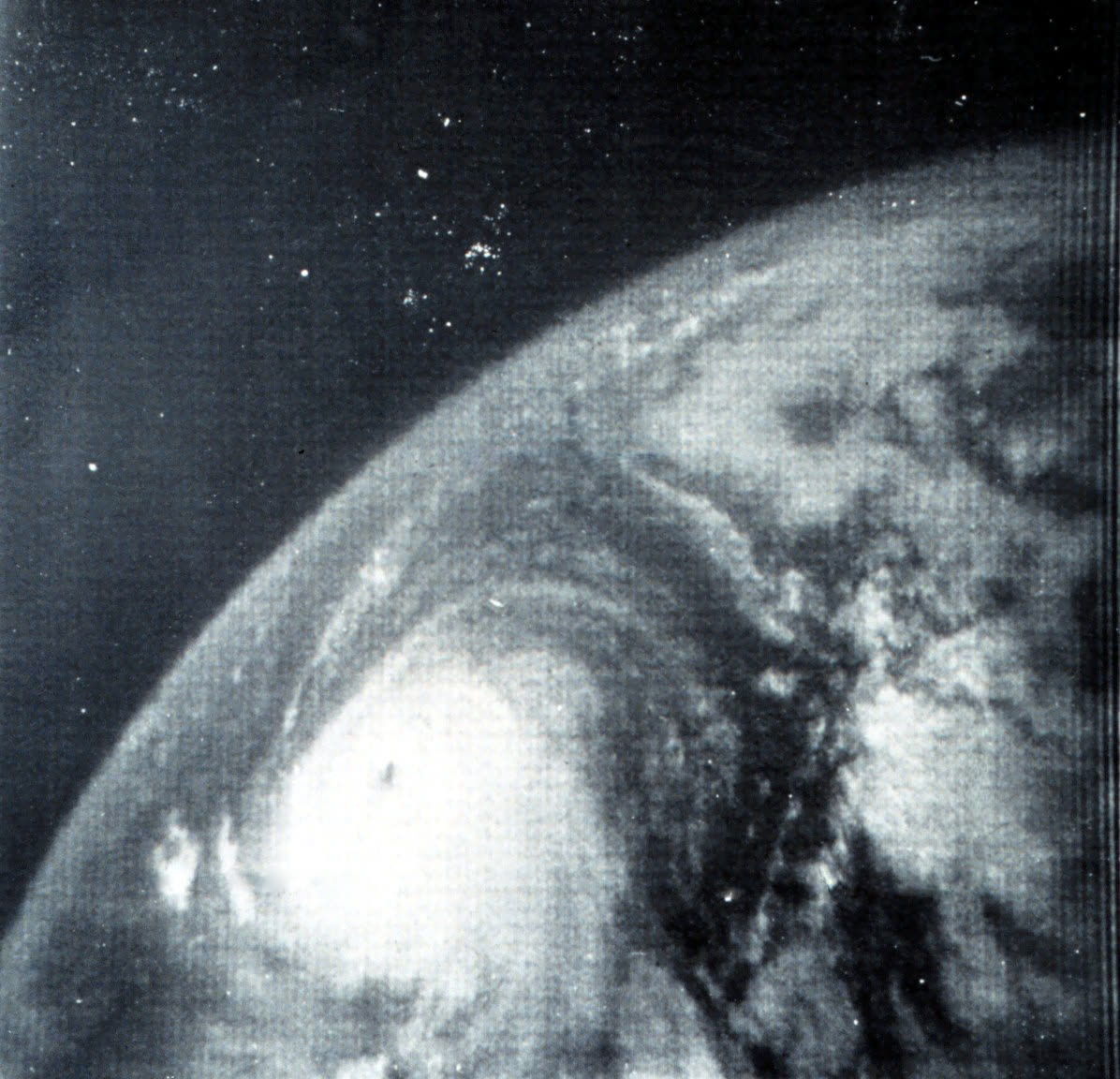
Betsy over the Atlantic on September 4, 1965, imaged by NASA's TIROS VIII weather satellite before the storm's loop toward the Bahamas and Florida
STORM ARCHIVE / 1965 LANDFALL 25.2°N 80.4°W
3 (FL) AT LANDFALL PEAK CAT 4 FL · 1965 · 155 mph

Hurricane Betsy

Landfall: Key Largo, FL → Grand Isle, LA · 1965-09-08. America's first billion-dollar hurricane — the loss that pushed Congress to create the National Flood Insurance Program in 1968

NASA / NOAA (TIROS VIII)
AT LANDFALL
3 (FL)
PEAK INTENSITY
CAT 4 · 155 mph
PRESSURE
953 mb (FL landfall)
STORM SURGE
9 ft
DAMAGE
$1.42B
DEATHS
81
01 THE PATH

Where it hit, start to finish

TRACK · HURRICANE BETSYNOAA / NHC (best-track data)
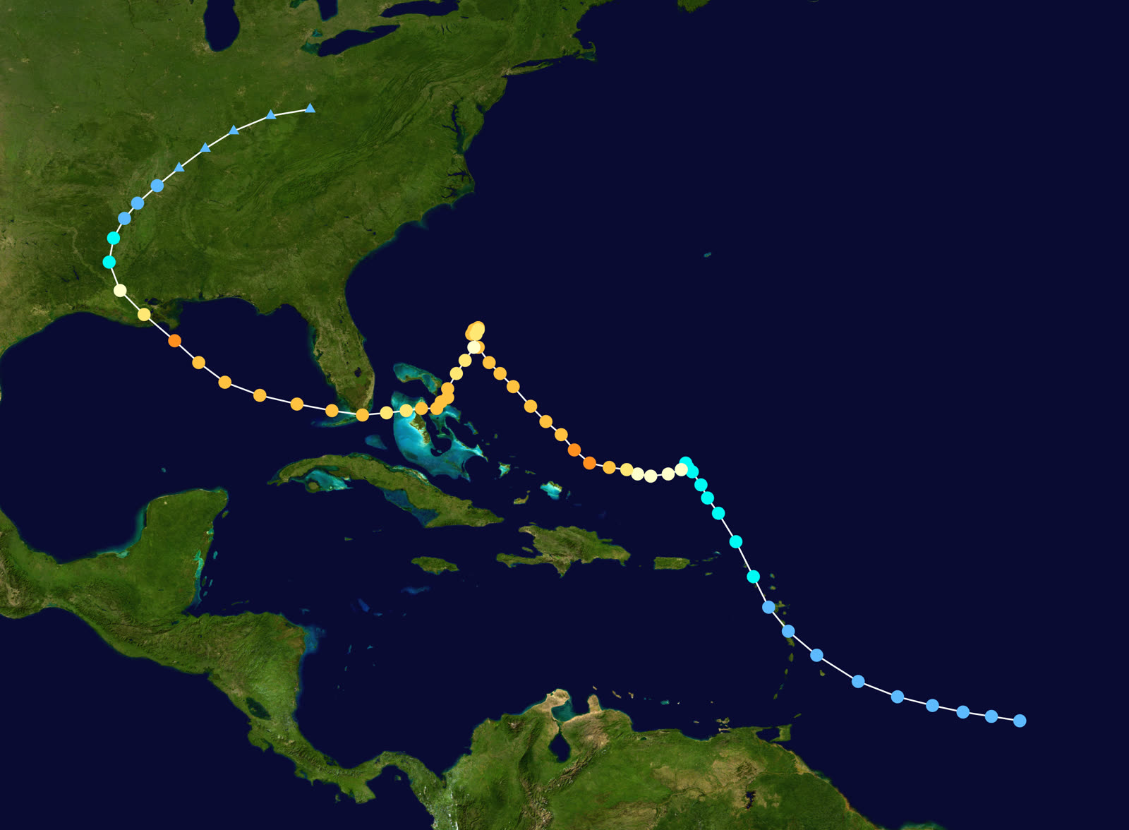
Best track of Hurricane Betsy, August 27 - September 12, 1965 - the anticyclonic loop north of the Bahamas turned a recurving storm into a Florida and Gulf catastrophe
Bahamas / offshore FL
THE LOOP

Betsy formed north of French Guiana on August 27, 1965, stalled north of the Bahamas, and executed a full anticyclonic loop - reversing from a harmless recurve into a southwest run at Florida.

Key Largo, FL
CAT 3 LANDFALL - 125 MPH

Landfall early September 8 with 125 mph winds and 953 mb pressure. Storm surge peaked at 9 feet at North Key Largo and 7.7 feet at Tavernier; peak US rainfall of 11.80 inches fell at Plantation Key.

South Florida
$139M FL DAMAGE

Florida damage reached $139 million with five deaths. An estimated 25-50% of the citrus crop and 90% of the avocado crop were damaged; the Keys and southern Miami-Dade flooded from both ocean and bay sides.

Gulf of Mexico
RE-INTENSIFICATION TO CAT 4

Betsy crossed into the Gulf, strengthened to 942 mb, and grew into a large, fast-moving Category 4 aimed at southeast Louisiana.

Grand Isle, LA
LANDFALL - WINDS REPORTED TO 155 MPH

The second landfall came the night of September 9-10 at Grand Isle. Surge pushed into Lake Pontchartrain and the Mississippi River Gulf Outlet, overtopping and breaching levees; the Lower Ninth Ward and eastern New Orleans flooded to the rooflines. Most of Betsy's 81 deaths were Louisiana drownings.

Mississippi Valley
DISSIPATION AND A NEW NUMBER

Betsy dissipated inland September 12. The enumerated damage total - $1.42 billion - made it the first US hurricane to cross $1 billion, unadjusted. Congress was in special session on relief within weeks.

02 THE RECORD IN IMAGES
ALL IMAGERY U.S. GOV / PUBLIC DOMAIN
SATELLITE NOAA / US Navy
Inside Betsy's eye, photographed from a Hurricane Hunter aircraft on September 3, 1965
RADAR NOAA / NWS (WSR-57)
Miami WSR-57 radar as Betsy's eye crossed the upper Keys near Key Largo, September 8, 1965
FLOOD US Government (public domain)
New Orleans' Lower Ninth Ward under water after Betsy's surge overtopped and breached levees - the flood that made federal flood insurance a national issue
AERIAL LBJ Presidential Library (public domain)
Flooded New Orleans seen from Air Force One as President Johnson toured the disaster, September 10, 1965
MAP NOAA / WPC
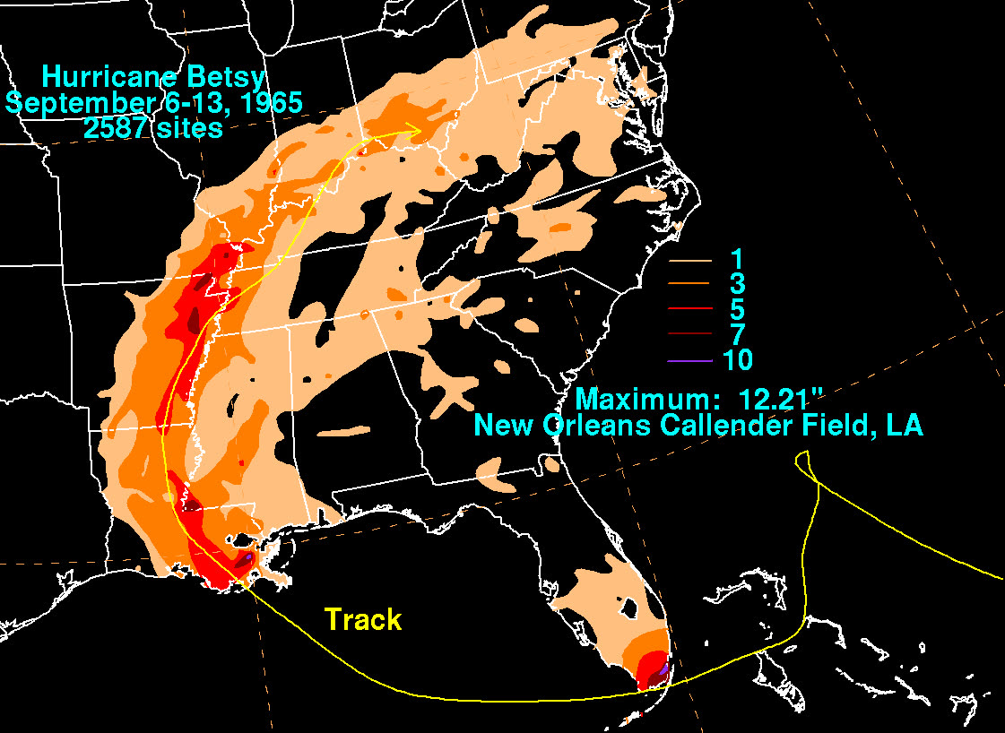
Betsy rainfall totals across the US - peak 11.80 inches at Plantation Key, FL

The storm

Betsy formed north of French Guiana on August 27, 1965, tracked toward the Bahamas, and then did the thing forecasters still cite six decades later: it stopped, looped, and reversed. The anticyclonic loop north of the Bahamas turned a storm headed out to sea into one driving southwest at Florida.

Landfall came at Key Largo early on September 8 — 125 mph winds, 953 mb, a strong Category 3. Surge peaked at 9 feet at North Key Largo and 7.7 feet at Tavernier; Plantation Key measured 11.80 inches of rain, the storm's US maximum. Betsy then crossed the Gulf, re-intensified to Category 4 strength (942 mb, winds reported to 155 mph), and slammed Grand Isle, Louisiana, on the night of September 9–10.

Surge funneled into Lake Pontchartrain and the newly dug Mississippi River Gulf Outlet, overtopping and breaching levees. New Orleans' Lower Ninth Ward flooded to the rooflines. Of Betsy's 81 deaths, most were Louisiana drownings.
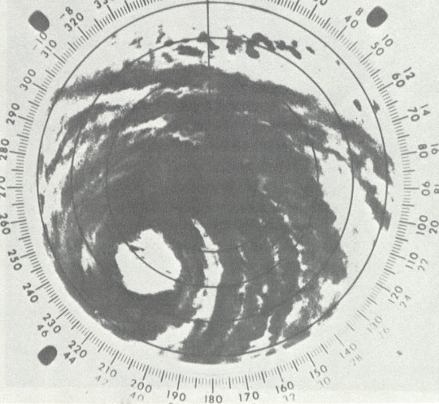
Miami WSR-57 radar as Betsy's eye crossed the upper Keys near Key Largo, September 8, 1965
Miami WSR-57 radar as Betsy's eye crossed the upper Keys near Key Largo, September 8, 1965 NOAA / NWS (WSR-57)

The damage

Florida's toll: $139 million and five deaths. The Keys took the direct hit — surge flooding from both ocean and bay sides, boats and waterfront structures wrecked from Key Largo through the middle Keys. Agriculture absorbed a large share of the state loss: an estimated 25–50% of the citrus crop and 90% of the avocado crop were damaged.

Louisiana's toll dwarfed it. Flooding covered large sections of eastern New Orleans, Chalmette, and the Lower Ninth Ward; thousands of residents were rescued from rooftops. When the counting finished, Betsy's enumerated damage was $1.42 billion — the first US hurricane to exceed $1 billion, unadjusted for inflation. The press named it "Billion-Dollar Betsy."
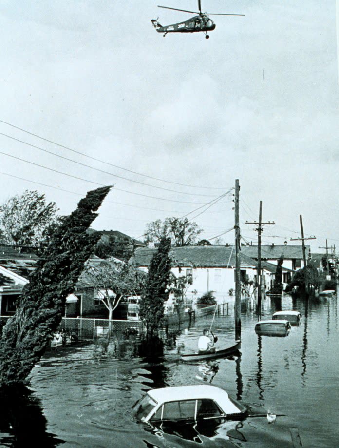
New Orleans' Lower Ninth Ward under water after Betsy's surge overtopped and breached levees - the flood that made federal flood insurance a national issue
New Orleans' Lower Ninth Ward under water after Betsy's surge overtopped and breached levees - the flood that made federal flood insurance a national issue US Government (public domain)

The insurance aftermath

Betsy is the most consequential storm in US flood-insurance history because of what its victims did not have: in 1965, flood insurance did not exist. Private insurers had abandoned the peril after the 1920s floods as uninsurable — losses too correlated, adverse selection too severe. Homeowners policies paid for wind damage and excluded rising water. Tens of thousands of flooded households in Louisiana and Florida had no policy that responded at all, and fell back on charity and ad-hoc federal relief.

Congress moved within weeks. President Johnson, who flew over flooded New Orleans on September 10 and told aides to "make the law bend to the problem," signed the Southeast Hurricane Disaster Relief Act of 1965 (P.L. 89-339) that November. Beyond direct relief, the Act ordered a federal study of whether flood risk could be insured at all. That study fed directly into the National Flood Insurance Act of 1968, creating the NFIP — the federal program that still writes the flood coverage on millions of Florida homes, and whose absence or presence still decides who gets paid after every surge event from Betsy to Helene.

Betsy also created the US Army Corps of Engineers' Hurricane Protection Program, which built the New Orleans levee system that failed in Katrina — 40 years later, on many of the same streets, triggering the Katrina wind-versus-water litigation. FEMA declarations DR-208 (Louisiana) and DR-209 (Florida) mark Betsy's place in the disaster-relief record.

The through-line for policyholders: every flood exclusion argument in a modern Florida hurricane claim traces to the line Betsy drew — wind is private insurance, rising water is the NFIP or nothing.
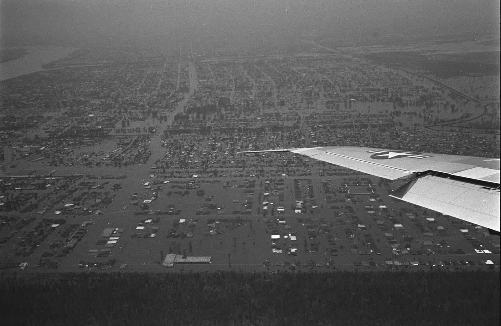
Flooded New Orleans seen from Air Force One as President Johnson toured the disaster, September 10, 1965
Flooded New Orleans seen from Air Force One as President Johnson toured the disaster, September 10, 1965 LBJ Presidential Library (public domain)

What policyholders learned

  • The flood exclusion is structural, not fine print. Betsy proved private carriers would not cover rising water; Congress built the NFIP (1968) around that refusal. Surge has been a separate policy ever since.
  • No flood policy meant no payment — in 1965 and now. Betsy's flooded households depended on relief acts and charity; today's equivalent is the NFIP policy bought before the storm.
  • Wind-versus-water disputes started here. With wind covered and water excluded on the same wrecked house, Betsy-era adjusters allocated damage between perils — the same causation fight litigated after Katrina and argued in Florida claims today.
  • Levees and infrastructure are part of the risk picture. Betsy's levee overtopping flooded neighborhoods that believed themselves protected; "protected" floodplains still carry the flood-coverage decision.
  • Catastrophe scale changes law. One storm produced a federal relief act, a flood-insurance study, the NFIP, and the Corps' hurricane-protection mission — the template for post-storm legislative response Florida has followed after Andrew, the 2004-05 seasons, and Ian.

Independent informational resource — not legal advice. Damage figures are nominal (not inflation-adjusted) unless noted. Insurance-law summaries are drafted for education; consult an attorney about your specific claim.

AT LANDFALL · HURRICANE BETSY · 1965
9 ft; ~10 ft (Lake Pontchartrain levees)
OF STORM SURGE · NORTH KEY LARGO
HURRICANELAW.PRO FIELD FOOTAGE
03 THE FULL RECORD

Every official record of Betsy

Reports, imagery archives, flood data, and claims records — straight from the agencies.

OUR LAW FIRM PARTNER · HALVERSEN LAW
Betsy claim denied?
CALL FL941-390-3233CALL SC843-542-0454FREE CLAIM REVIEW
RELATED GUIDES
HurricaneLaw.Pro HURRICANELAW.PRO

The independent policyholder resource for Florida & South Carolina — storm archive, coverage law, denials, bad faith, and the complete claims playbook. 51 storms · 46 carriers · 97 public-adjuster firms · 37 city guides.

▸ SEE THE FULL SITE MAP — EVERY PAGE →
STORM ALERTS SOURCED FROM NOAA / NHC
SOUTH CAROLINA
496 Bramson Court, Suite 100
Mount Pleasant, SC 29464
CALL OR TEXT
FLORIDA
Tampa, FL
CALL OR TEXT
CLAIMS 9
DENIALS 8
BAD FAITH 7
COVERAGE 12
COMMERCIAL 8
ROOFS 8
TREES 5
DIRECTORIES
STORMS 51
WEATHER
NEWS & SITE 19
STORM ARCHIVE, CITIES & NEWS
Most recent below. Every storm dossier, city resource, and article is on its hub (linked at each heading) or the grouped site map →. All 46 carriers and 97 public-adjuster firms are in the Directories column above.
STORM ARCHIVE · 51 →
Hurricane Debby 2024Hurricane Helene 2024Hurricane Milton 2024Hurricane Idalia 2023Hurricane Ian 2022Hurricane Nicole 2022Hurricane Ida 2021Hurricane Laura 2020 View all 51 →
FLORIDA CITY RESOURCES · 29 →
Boca RatonBradentonCape CoralClearwaterDaytona BeachDestinFort LauderdaleFort Myers View all 29 →
SOUTH CAROLINA CITY RESOURCES · 8 →
BeaufortCharlestonColumbiaFlorenceGreenvilleHilton Head IslandMount PleasantMyrtle Beach
NEWS & UPDATES · 19 →

HurricaneLaw.Pro is an independent informational resource, not a law firm. Coverage summaries, policy-language quotations, dollar figures, deadlines, and chart examples throughout this site are general information based on typical or standard policy forms and are illustrative only — they are not a quote, a guarantee of coverage, or a promise of any outcome. Every insurance policy is different: your own policy, endorsements, and state law control, so read your policy and confirm current statutes. Weather imagery courtesy of NOAA, the National Hurricane Center, and the National Weather Service. Legal services are provided by our law firm partner, Halversen Law. Nothing on this site is legal advice; consult an attorney about your specific claim.

PrivacyTermsDisclaimerAboutContact
© 2026 HURRICANELAW.PRO — ALL RIGHTS RESERVED 27.9°N 82.5°W · ATLANTIC BASIN MONITOR
OUR LAW FIRM PARTNER
Halversen Law LICENSED · FLORIDA & SOUTH CAROLINA

All legal matters on this site are referred to and handled by our law firm partner, Halversen Law, a licensed law firm in Florida and South Carolina. HurricaneLaw.Pro is an informational resource and is not itself a law firm.

FREE CASE REVIEW