
PROPERTY-INSURANCE CLAIM HELP · FL & SC FL CITIESSC CITIESGUIDESTATESNEWSSITE MAPABOUT
HurricaneLaw.Pro HURRICANELAW.PRO
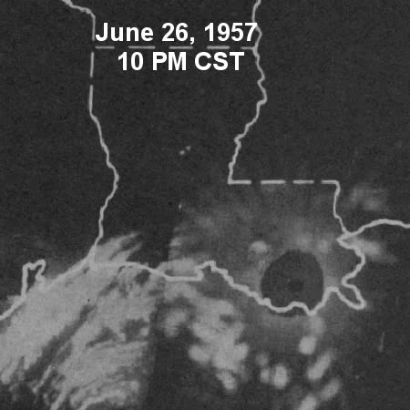
Lake Charles radar animation of Audrey approaching the Louisiana coast — Audrey was among the first hurricanes tracked by land-based radar
STORM ARCHIVE / 1957 LANDFALL 29.8°N 93.9°W
CAT 3 US · 1957 · 125 mph

Hurricane Audrey

Landfall: Between Sabine Pass, TX and Cameron, LA · 1957-06-27. With no flood program until 1968, Audrey's surge losses were unpayable — survivors sued the Weather Bureau over the warnings instead, in Bartie v. United States, the first case of its kind

NOAA / NWS Lake Charles
AT LANDFALL
CAT 3
PEAK WIND
125 mph
PRESSURE
946 mb
STORM SURGE
8-12 ft
DAMAGE
~$150M
DEATHS
416+
01 THE PATH

Where it hit, start to finish

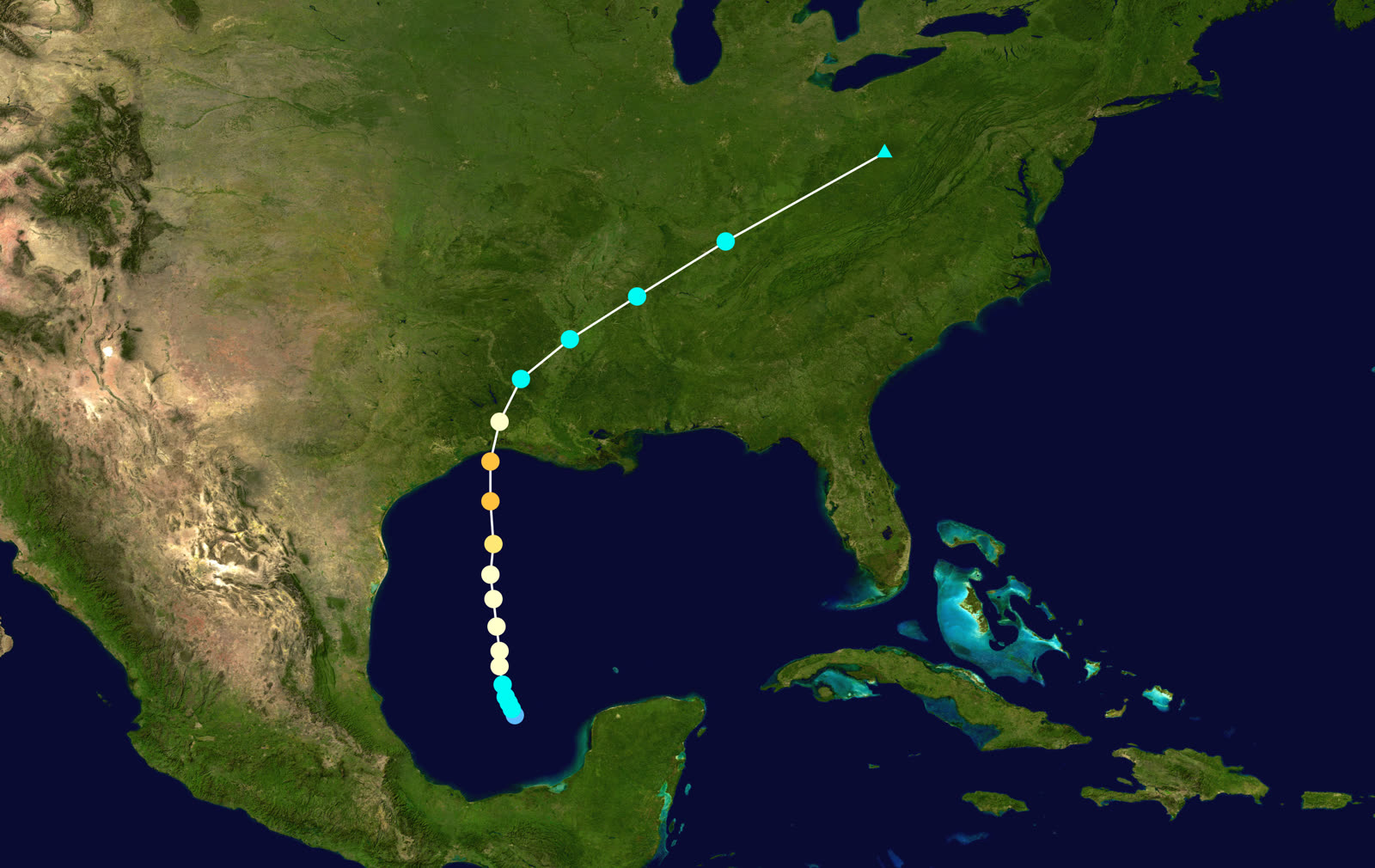
TRACK · HURRICANE AUDREYNOAA (HURDAT best-track data)
Best track of Hurricane Audrey, June 24-29, 1957 — a due-north Gulf track with no time to weaken
Bay of Campeche
JUNE FORMATION

Audrey formed June 24-25 in the southwestern Gulf — an unusually strong storm for June — and moved due north toward the Texas-Louisiana line.

Central Gulf
OVERNIGHT ACCELERATION

Forecasts on June 26 placed landfall late June 27 or June 28. Overnight the storm accelerated and intensified; it arrived at dawn, roughly 12 hours ahead of many residents' expectations. Evening radio broadcasts had led families in low-lying Cameron Parish to plan on evacuating in the morning.

Sabine Pass, TX / Cameron, LA
LANDFALL AT DAWN - CAT 3, 125 MPH

Landfall the morning of June 27 with winds near 125 mph and pressure of 946 mb. Storm surge of 8-12 feet rolled across marshland that stands only feet above sea level.

Cameron Parish, LA
SURGE 25 MILES INLAND - 416+ DEAD

The surge penetrated up to 25 miles inland. Whole communities — Cameron, Creole, Grand Chenier — were swept; families rode rooftops and debris into the marsh. The official toll of 416+ is widely considered an undercount; some estimates exceed 500.

Lower Mississippi Valley / Midwest
INLAND MERGER

Audrey weakened inland, merged with a frontal system, and produced damaging winds and flooding rain north to the Great Lakes and into Canada June 28-29, adding to the toll and pushing total damage to about $150 million.

02 THE RECORD IN IMAGES
ALL IMAGERY U.S. GOV / PUBLIC DOMAIN
MAP NOAA Central Library
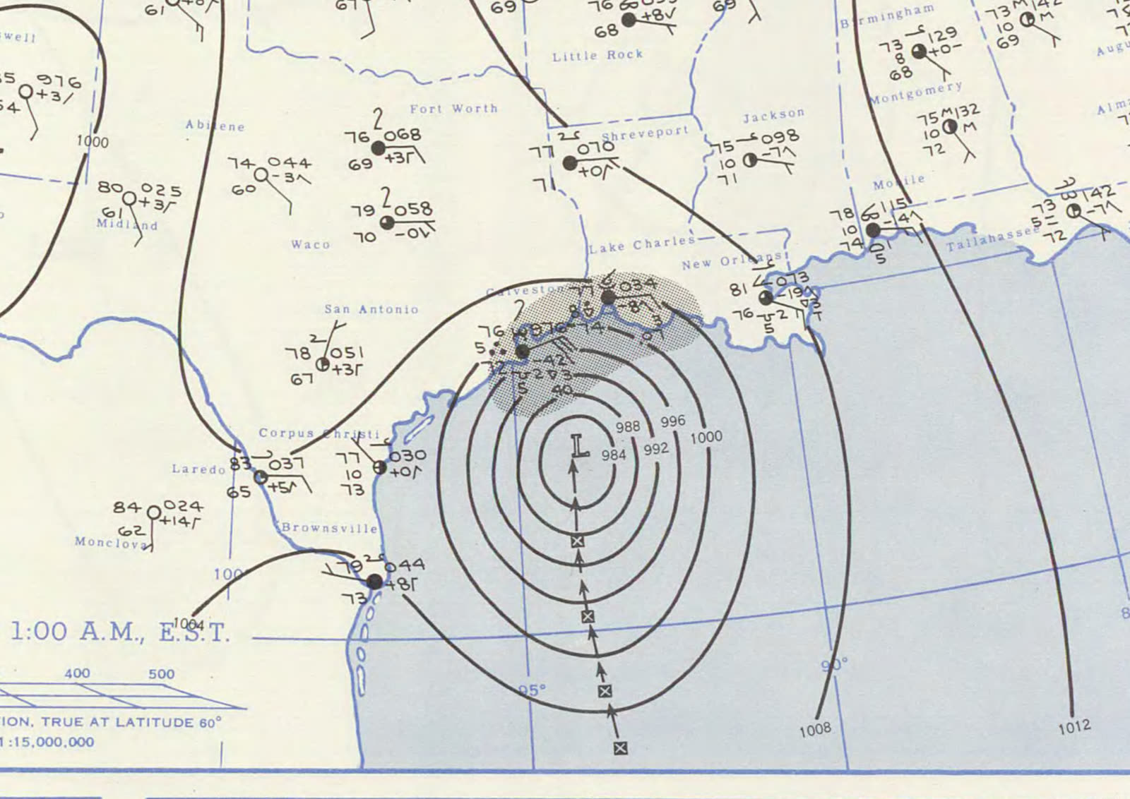
Surface weather map the morning of landfall, June 27, 1957
MAP NOAA / U.S. Weather Bureau
Weather Bureau landfall summary from the Monthly Weather Review account of Audrey
SURGE NOAA / NHC
NHC historical reconstruction of Audrey's track and storm surge — 8-12 feet across Cameron Parish
MAP NOAA / WPC (David Roth)
Rainfall footprint from the Gulf coast to the Great Lakes as Audrey merged with a frontal system

The storm

Audrey formed in the Bay of Campeche on June 24-25, 1957 — an unusually powerful storm for June — and moved due north across the Gulf toward the Texas-Louisiana border. It was among the first hurricanes tracked by land-based radar, from the Lake Charles station.

The forecast problem was timing. Advisories on June 26 pointed to a landfall late on June 27 or the 28th, and evening radio coverage led many families in Cameron Parish to plan a morning evacuation. Overnight, Audrey accelerated and strengthened. It made landfall at dawn on June 27 between Sabine Pass, Texas, and Cameron, Louisiana, as a Category 3 with 125 mph winds and a central pressure of 946 mb — roughly 12 hours earlier than many residents expected.

Storm surge of 8-12 feet swept across Cameron Parish marshland that sits only a few feet above sea level, penetrating up to 25 miles inland. At least 416 people died — the official figure is widely considered an undercount, with some estimates above 500. Audrey remains the deadliest U.S. hurricane between 1928 and Katrina.
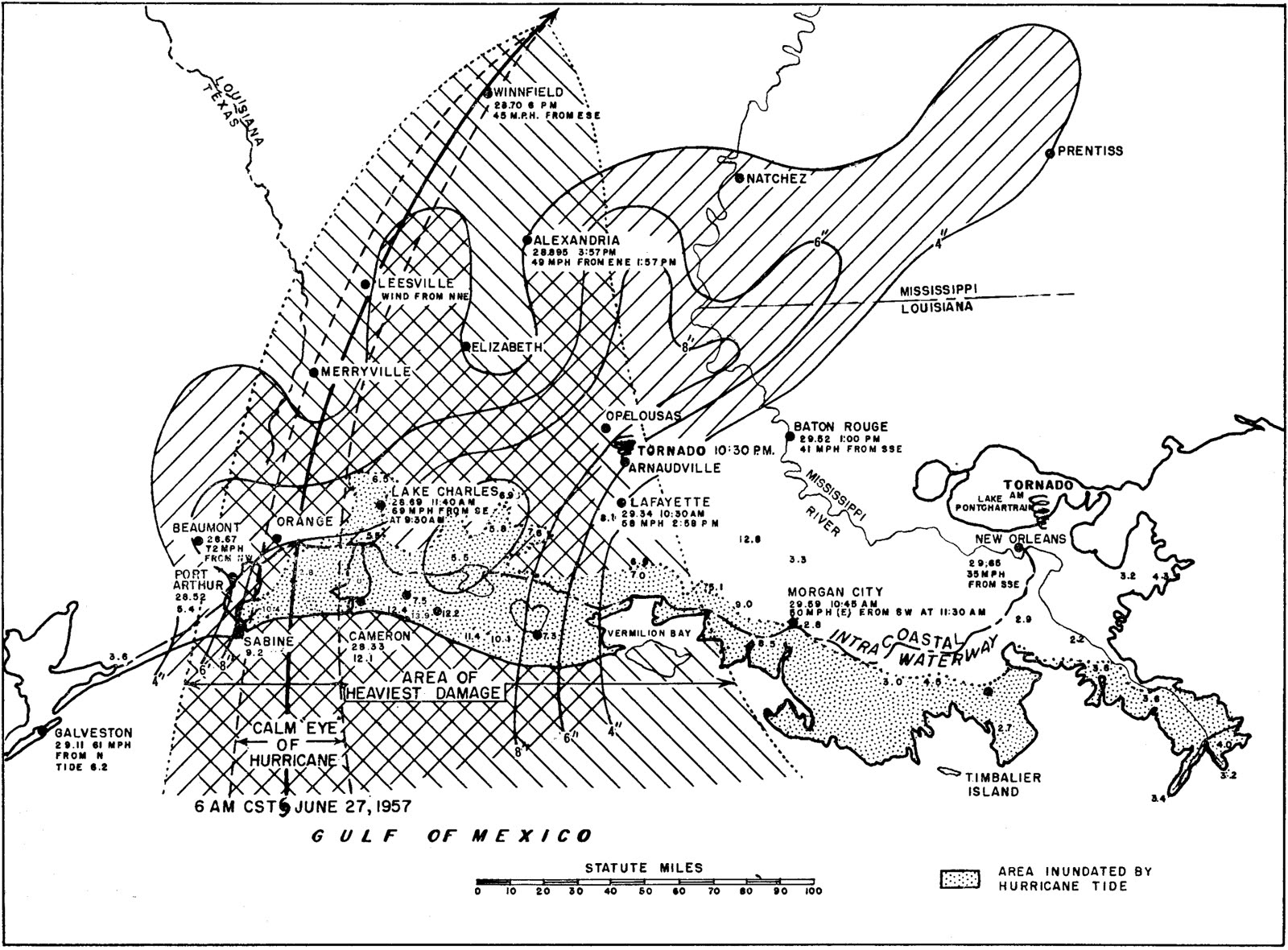
Weather Bureau landfall summary from the Monthly Weather Review account of Audrey
Weather Bureau landfall summary from the Monthly Weather Review account of Audrey NOAA / U.S. Weather Bureau

The damage

Cameron Parish took the catastrophe nearly whole. The communities of Cameron, Creole, and Grand Chenier were effectively erased; houses floated off foundations and broke apart in the marsh, and survivors rode rooftops and debris for miles. Between 60 and 80 percent of the homes across the parish's coastal reach were destroyed or made uninhabitable.

Wind damage extended into Lake Charles and east Texas. Inland, Audrey merged with a frontal system and carried damaging winds and flooding rain north to the Great Lakes and into Canada. Total damage reached about $150 million in 1957 dollars.
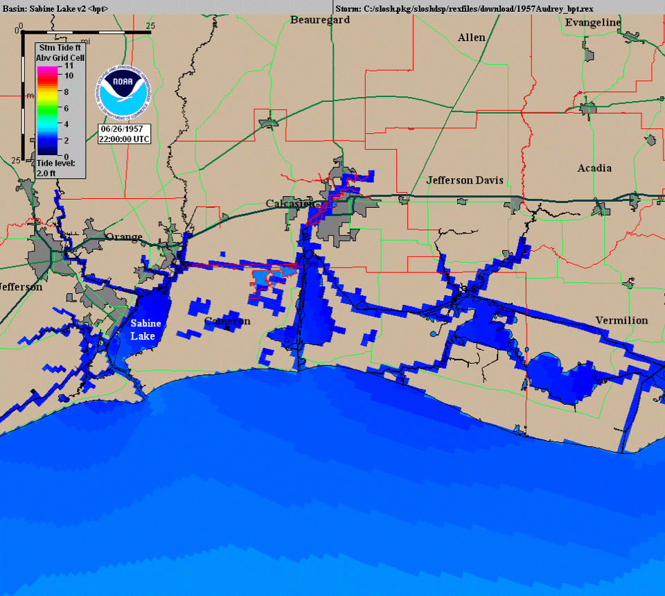
NHC historical reconstruction of Audrey's track and storm surge — 8-12 feet across Cameron Parish
NHC historical reconstruction of Audrey's track and storm surge — 8-12 feet across Cameron Parish NOAA / NHC

The insurance aftermath

Audrey's losses were overwhelmingly surge losses, and in 1957 there was nowhere for them to go. The National Flood Insurance Program would not exist for another 11 years; private flood coverage for homes was effectively unavailable. Fire policies with extended coverage responded to wind damage only. For families whose homes had been carried into the marsh by water, the insurance answer was, in most cases, nothing.

That vacuum produced the storm's legal legacy. With no policy to claim against, survivors sued the government over the warnings. In Bartie v. United States, filed on behalf of Cameron Parish families under the Federal Tort Claims Act, resident Whitney Bartie — who lost his wife and five children — alleged the Weather Bureau was negligent in "failing to give adequate, clear, correct, and proper warning" of Audrey's intensity, surge, and arrival time, and that his family stayed home in reliance on the advisories. It was the first suit of its kind against the Weather Bureau. The federal court in Louisiana ruled for the government in 1963 (216 F. Supp. 10), crediting expert testimony that the warnings were as accurate as the era's science allowed, and the Fifth Circuit affirmed. The doctrine that emerged — government forecasts essentially cannot be sued over — still stands, and it channels post-storm recovery fights back where they live today: policyholder versus insurer.

Audrey also became a standing exhibit in the case for a federal flood program. Along with Betsy (1965), it demonstrated that surge risk was uninsurable in the private market and that the losses landed on disaster relief — the argument that produced the NFIP in 1968.
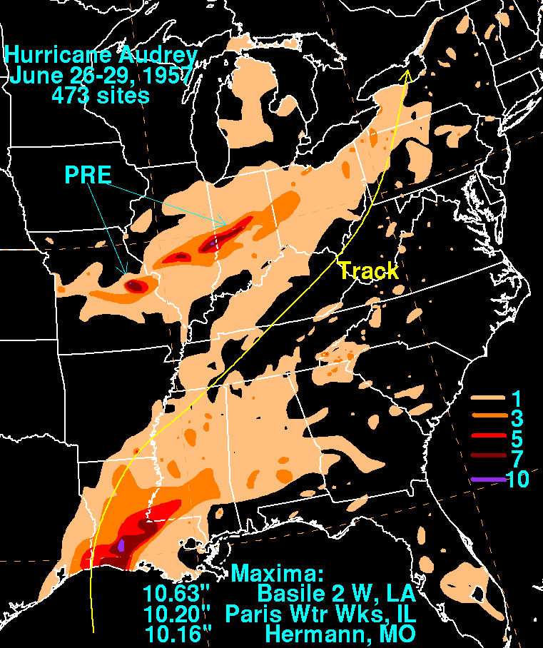
Rainfall footprint from the Gulf coast to the Great Lakes as Audrey merged with a frontal system
Rainfall footprint from the Gulf coast to the Great Lakes as Audrey merged with a frontal system NOAA / WPC (David Roth)

What policyholders learned

  • There was no flood claim to file. Audrey-era families learned the wind/water line the hardest way: wind coverage paid on wind damage that could be proven, and surge losses fell entirely on the owner. The exclusion structure is unchanged today; only the NFIP fills the gap.
  • Warning-failure suits do not pay. Bartie established that forecast error is not a compensable claim. The only recovery path after a surge disaster runs through insurance bought before the storm.
  • Proving wind before water mattered even in 1957. Where structures showed wind failure before inundation, extended-coverage wind policies could respond; total washaways paid nothing. Documentation and debris evidence made the difference.
  • Timing risk is part of surge risk. Audrey arrived 12 hours early. Policies and preparation built around "we'll leave in the morning" failed. Evacuation-window optimism has no coverage.
  • Undercounted losses stay undercounted. With whole families lost and records destroyed, Cameron Parish's true toll was never established — a reminder that post-storm proof depends on records that survive the storm.

Independent informational resource — not legal advice. Damage figures are nominal (not inflation-adjusted) unless noted. Insurance-law summaries are drafted for education; consult an attorney about your specific claim.

AT LANDFALL · HURRICANE AUDREY · 1957
8-12 ft, penetrating up to 25 miles inland
OF STORM SURGE · CAMERON PARISH
HURRICANELAW.PRO FIELD FOOTAGE
03 THE FULL RECORD

Every official record of Audrey

Reports, imagery archives, flood data, and claims records — straight from the agencies.

OUR LAW FIRM PARTNER · HALVERSEN LAW
Audrey claim denied?
CALL FL941-390-3233CALL SC843-542-0454FREE CLAIM REVIEW
RELATED GUIDES
HurricaneLaw.Pro HURRICANELAW.PRO

The independent policyholder resource for Florida & South Carolina — storm archive, coverage law, denials, bad faith, and the complete claims playbook. 51 storms · 46 carriers · 97 public-adjuster firms · 37 city guides.

▸ SEE THE FULL SITE MAP — EVERY PAGE →
STORM ALERTS SOURCED FROM NOAA / NHC
SOUTH CAROLINA
496 Bramson Court, Suite 100
Mount Pleasant, SC 29464
CALL OR TEXT
FLORIDA
Tampa, FL
CALL OR TEXT
CLAIMS 9
DENIALS 8
BAD FAITH 7
COVERAGE 12
COMMERCIAL 8
ROOFS 8
TREES 5
DIRECTORIES
STORMS 51
WEATHER
NEWS & SITE 19
STORM ARCHIVE, CITIES & NEWS
Most recent below. Every storm dossier, city resource, and article is on its hub (linked at each heading) or the grouped site map →. All 46 carriers and 97 public-adjuster firms are in the Directories column above.
STORM ARCHIVE · 51 →
Hurricane Debby 2024Hurricane Helene 2024Hurricane Milton 2024Hurricane Idalia 2023Hurricane Ian 2022Hurricane Nicole 2022Hurricane Ida 2021Hurricane Laura 2020 View all 51 →
FLORIDA CITY RESOURCES · 29 →
Boca RatonBradentonCape CoralClearwaterDaytona BeachDestinFort LauderdaleFort Myers View all 29 →
SOUTH CAROLINA CITY RESOURCES · 8 →
BeaufortCharlestonColumbiaFlorenceGreenvilleHilton Head IslandMount PleasantMyrtle Beach
NEWS & UPDATES · 19 →

HurricaneLaw.Pro is an independent informational resource, not a law firm. Coverage summaries, policy-language quotations, dollar figures, deadlines, and chart examples throughout this site are general information based on typical or standard policy forms and are illustrative only — they are not a quote, a guarantee of coverage, or a promise of any outcome. Every insurance policy is different: your own policy, endorsements, and state law control, so read your policy and confirm current statutes. Weather imagery courtesy of NOAA, the National Hurricane Center, and the National Weather Service. Legal services are provided by our law firm partner, Halversen Law. Nothing on this site is legal advice; consult an attorney about your specific claim.

PrivacyTermsDisclaimerAboutContact
© 2026 HURRICANELAW.PRO — ALL RIGHTS RESERVED 27.9°N 82.5°W · ATLANTIC BASIN MONITOR
OUR LAW FIRM PARTNER
Halversen Law LICENSED · FLORIDA & SOUTH CAROLINA

All legal matters on this site are referred to and handled by our law firm partner, Halversen Law, a licensed law firm in Florida and South Carolina. HurricaneLaw.Pro is an informational resource and is not itself a law firm.

FREE CASE REVIEW